干旱区研究 ›› 2021, Vol. 38 ›› Issue (3): 843-854.doi: 10.13866/j.azr.2021.03.26
文广超( ),赵梅娟,谢洪波,张毅,张娟
收稿日期:2020-09-22
修回日期:2020-11-06
出版日期:2021-05-15
发布日期:2021-06-17
作者简介:文广超(1979-),男,博士,副教授,主要从事流域水文过程与生态环境保护、地学信息技术与“3S”集成应用等方面的教学与科研工作. E-mail: 基金资助:
WEN Guangchao(),ZHAO Meijuan,XIE Hongbo,ZHANG Yi,ZHANG Juan
Received:2020-09-22
Revised:2020-11-06
Online:2021-05-15
Published:2021-06-17
摘要:
为了揭示伊犁河谷西部地区土地植被覆盖演化的驱动因素,选取2001—2016年16景卫星影像数据,基于“3S”技术,运用图像分类、叠加分析、统计分析等方法,分析了研究区土地植被覆盖时空演化规律,应用地理探测器模型定量探究了影响土地植被覆盖演化的主要驱动力。结果表明:(1) 2001—2016年,裸地、草地、林地、耕地占总面积87%,占土地利用类型主导地位,构成区域土地利用基本格局,建设用地持续增加,冰川、沙地及水域面积持续减少;(2) 研究区植被大面积稳定演进,低植被覆盖面积减少约1333 km2,高植被覆盖等级面积持续增加1020 km2,植被覆盖由中低等水平向较高和高植被覆盖等级转变;(3) 利用地理探测器识别出研究区土地植被覆盖演化受自然和人类因素共同影响,降雨、气温、人口、GDP及高程为演化的主要因子,部分因子对土地植被变化的差异性显著,出现双因子协同增强现象;(4) 气象要素是区域土地植被覆盖演化的主要驱动因素,人类活动为次要驱动因素。
文广超,赵梅娟,谢洪波,张毅,张娟. 伊犁河谷西部土地植被覆盖演化及驱动力分析[J]. 干旱区研究, 2021, 38(3): 843-854.
WEN Guangchao,ZHAO Meijuan,XIE Hongbo,ZHANG Yi,ZHANG Juan. Analysis of land vegetation cover evolution and driving forces in the western part of the Ili River Valley[J]. Arid Zone Research, 2021, 38(3): 843-854.

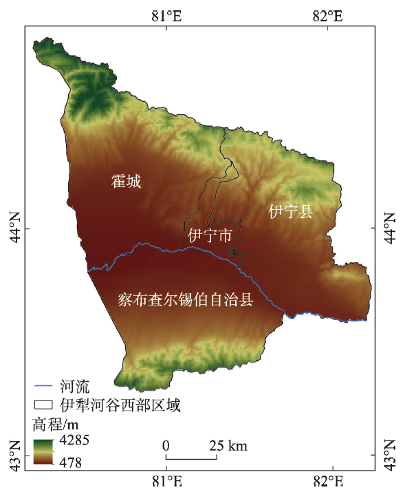
图1
研究区位置图"
Tab. 1
Data source"
| 数据名称 | 数据来源 | 空间分辨率 | 时间分辨率 | 备注 |
|---|---|---|---|---|
| Landsat数据 | 美国地质调查局( | 30 m×30 m | 16 d | 2001、2006、2011、2016年8—9月共16景 |
| DEM数据 | 地理空间数据云( | 90 m | 16 d | 若干幅DEM数据 |
| 气象数据 | 中国气象数据分享平台( | - | - | 2001—2016年逐月气象数据 |
| 人口、经济等数据 | 《伊犁哈萨克自治州统计年鉴》 | - | 1 a | 2001—2016年 |
| 水文地质数据 | 伊犁河谷西部平原区1:50000水文地质调查实施方案 | - | - | 2018年 |
| 验证数据 | 中国地质调查局西安地质调查中心 | - | 5 a | 1:100000土地利用标准分类图 |
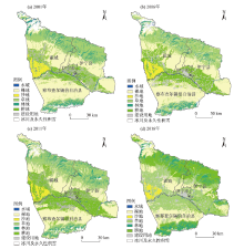
图2
2001—2016年伊犁河谷西部地区土地利用分类图"

表2
2001—2016年土地类利用型动态度"
| 时段 | 土地类利用型 | |||||||
|---|---|---|---|---|---|---|---|---|
| 水域/% | 裸地/% | 沙地/% | 冰川/% | 建设用地/% | 草地/% | 林地/% | 耕地/% | |
| 2001—2006年 | -1.76 | 0.45 | -5.04 | -2.60 | 1.26 | -3.18 | 0.72 | 4.94 |
| 2006—2011年 | -1.53 | -4.70 | -1.36 | -3.27 | 0.92 | -0.75 | 1.53 | 5.83 |
| 2011—2016年 | -4.02 | -4.55 | -0.89 | -4.29 | 5.27 | 4.42 | -1.13 | 5.35 |
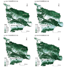
图3
2001—2016年植被覆盖度分级"

表3
2001—2016年植被覆盖度分级"
| 年份 | 植被覆盖度分级 | ||||
|---|---|---|---|---|---|
| 低/% | 较低/% | 中度/% | 较高/% | 高/% | |
| 2001 | 19.13 | 18.47 | 13.13 | 20.45 | 28.82 |
| 2006 | 16.05 | 20.64 | 15.23 | 19.85 | 28.23 |
| 2011 | 14.83 | 16.20 | 14.40 | 18.98 | 35.59 |
| 2016 | 10.27 | 14.74 | 18.02 | 21.37 | 35.60 |
| 2001—2016 | 15.07 | 17.51 | 15.20 | 20.16 | 32.06 |

图4
土地利用类型与多年植被覆盖度均值的关系"
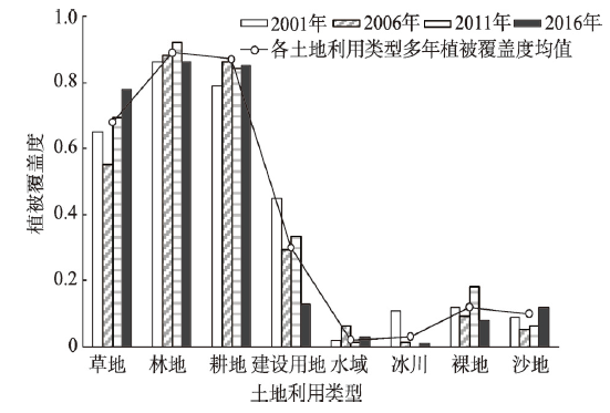
表4
2001—2016年植被覆盖度变化类型"
| 植被覆 盖度变化 | 面积/km2 | 占比/% | 主要土地 利用类型 |
|---|---|---|---|
| 显著减少 | 725.07 | 4.82 | 水域、冰川、建设用地的中高植被 |
| 减少 | 1766.05 | 11.74 | 水域、裸地、稀疏草地、林地 |
| 稳定 | 6602.37 | 43.89 | 建设用地、耕地、中高草地 |
| 增加 | 3329.02 | 22.13 | 耕地、草地、林地、建设用地低植被 |
| 明显增加 | 2620.49 | 17.42 | 耕地、林地 |

图5
2001—2016年降水量、气温与植被覆盖度变化"
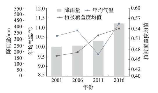
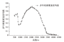
图6
多年植被覆盖度均值与高程关系"
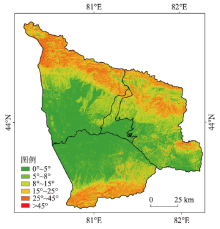
图7
研究区坡度分级"

表5
植被覆盖度与坡度的关系"
| 坡度范围 | 植被覆盖度均值 | 面积占比/% |
|---|---|---|
| 0°~5° | 0.29 | 43.46 |
| 5°~8° | 0.37 | 12.24 |
| 8°~15° | 0.47 | 16.72 |
| 15°~25° | 0.43 | 13.90 |
| 25°~45° | 0.42 | 13.24 |
| >45° | 0.40 | 0.44 |

图8
多年植被覆盖度均值与地貌类型关系"

表6
植被区划、覆盖度与水位埋深的关系"
| 水位埋深/m | 植被覆盖度 | 区域划分 | 植被代表类型 |
|---|---|---|---|
| 0~2 | 0.7~0.9 | 人工生态区农业绿洲;自然生态区沼泽、湿地 | 玉米、小麦等;野蔷薇、沙棘等灌木;芦苇、芦草等 |
| 2~7 | 0.2~0.4 | 自然生态区半荒漠、沙漠、盐碱滩地 | 梭梭、沙拐枣等;白刺、白梭梭、沙蓬;盐蒿、盐角草、碱柴等 |
| >7 | <0.05 | 自然生态区荒漠 | 梭梭、红柳、琵琶柴等 |
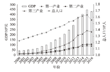
图9
研究区人口、GDP和产业结构变化"
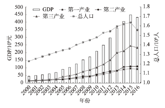
表7
植被覆盖度和土地利用类型的生态探测器分析结果"
| 生境因子 | X1 | X2 | X3 | X4 | X5 | X6 | X7 |
|---|---|---|---|---|---|---|---|
| X1 | |||||||
| X2 | N | ||||||
| X3 | Y | Y | |||||
| X4 | Y | N | N | ||||
| X5 | Y | Y | Y | Y | |||
| X6 | Y | N | N | N | Y | ||
| X7 | Y | N | N | N | N | Y | |
| X8 | Y | N | N | N | N | Y | Y |
表8
主导因子交互作用及关系分析"
| X∩Y | q(X∩Y)植被 | q(X∩Y)土地 | 交互关系 |
|---|---|---|---|
| 降雨∩水位埋深 | 0.628 | 0.593 | 双因子协同增强 |
| 降雨∩地貌 | 0.546 | 0.552 | 双因子协同增强 |
| 气温∩人口 | 0.498 | 0.537 | 双因子协同增强 |
| 高程∩坡度 | 0.473 | 0.483 | 双因子协同增强 |
| 气温∩GDP | 0.451 | 0.445 | 双因子协同增强 |
| 人口∩高程 | 0.424 | 0.416 | 双因子协同增强 |
| [1] | 姚昆, 张存杰, 何磊, 等. 川西北高原区生态环境脆弱性评价[J]. 水土保持研究, 2020,27(4):349-355, 362. |
| [ Yaokun, Zhang Cunjie, He lei, et al. Evaluation of ecological environment vulnerability in the northwest plateau area of Sichuan[J]. Research of Soil and Water Conservation, 2020,27(4):349-355, 362. ] | |
| [2] | 赵鹏, 陈桃, 王茜, 等. 气候变化和人类活动对新疆草地生态系统NPP影响的定量分析[J]. 中国科学院大学学报, 2020,37(1):51-62. |
| [ Zhaopeng, Chentao, Wangqian, et al. Quantitative analysis of the impact of climate change and human activities on grassland ecosystem NPP in Xinjiang[J]. Journal of University of Chinese Academy of Sciences, 2020,37(1):51-62. ] | |
| [3] | 加尔肯居马肯·爱特, 朱海涌. 伊犁河谷生态功能区划探讨[J]. 环境科学与管理, 2009,34(4):140-146. |
| [ Jarkhen Jumakhen Aite, Zhu Haiyong. Discussion of ecological function division of Ili River Valley[J]. Environmental Science and Management, 2009,34(4):140-146. ] | |
| [4] | 伊犁州统计局. 伊犁哈萨克自治州统计年鉴(1999—2017年)[M]. 奎屯: 伊犁人民出版社, 2018. |
| [ Ili Bureau of Statistics. Ili Kazakh Autonomous Prefecture Statistical Yearbook (1999-2017) [M]. Kuytun: Ili People’s Publishing House, 2018. ] | |
| [5] | 麦麦提吐尔逊·艾则孜, 海米提·依米提, 孙慧兰, 等. 伊犁河流域土壤盐分与地下水关系的关联分析[J]. 土壤通报, 2013,44(3):561-566. |
| [ Mamattursun Eziz, Hamid Yimit, Sun Huilan, et al. Correlation analysis on correlation between soil salinity and groundwater in Ili River Basin[J]. Chinese Journal of Soil Science, 2013,44(3):561-566. ] | |
| [6] | 加尔肯居马肯·爱特, 王文杰, 朱海涌, 等. 基于RS-GIS伊犁河谷土地利用-土地覆盖变化研究[J]. 中国环境监测, 2009,25(2):69-72. |
| [ Jarkhen Jumakhen Aite, Wang Wenjie, Zhu Haiyong, et al. Investigation of land use/land cover of Ili River Valley based on RS-GIS[J]. Environmental Monitoring in China, 2009,25(2):69-72. ] | |
| [7] | 汪洋, 靳瑰丽, 李卫红, 等. 伊犁河谷土地利用变化对生态服务价值的影响[J]. 环境与可持续发展, 2017,42(2):151-155. |
| [ Wang Yang, Jin Guli, Li Weihong, et al. The spatial coupling of land use/cover change and its environmental effects on Ili Valley[J]. Environment and Sustainable Development, 2017,42(2):151-155. ] | |
| [8] | 陈晨, 张哲, 王文杰, 等. 基于GIS的伊犁河谷地区生态承载力研究[J]. 环境工程技术学报, 2013,6(3):532-539. |
| [ Chen Chen, Zhang Zhe, Wang Wenjie, et al. Study on Ili River Valley area ecological carrying capacity based on GIS[J]. Journal of Environmental Engineering Technology, 2013,6(3):532-539. ] | |
| [9] | 许茜, 李奇, 陈懂懂, 等. 近40a三江源地区土地利用变化动态分析及预测[J]. 干旱区研究, 2018,35(3):695-704. |
| [ Xuqian, Liqi, Chen Dongdong, et al. Land use change in the three-river headwaters in recent 40 years[J]. Arid Zone Research, 2018,35(3):695-704. ] | |
| [10] | 刘吉平, 赵丹丹, 田学智, 等. 1954—2010年三江平原土地利用景观格局动态变化及驱动力[J]. 生态学报, 2014,34(12):3234-3244. |
| [ Liu Jiping, Zhao Dandan, Tian Xuezhi, et al. Landscape pattern dynamics and driving forces analysis in the Sanjiang Plain from 1954 to 2010[J]. Acta Ecologica Sinica, 2014,34(12):3234-3244. ] | |
| [11] | 阿依努·吐逊, 张青青, 徐海量, 等. 近57a玛纳斯河流域土地利用/覆被变化[J]. 干旱区研究, 2019,36(3):599-605. |
| [ Ayinu Tuxun, Zhang Qingqing, Xu Hailiang, et al. Land use/cover change in Manas River Basin in recent 57 years[J]. Arid Zone Research, 2019,36(3):599-605. ] | |
| [12] | 李丽君, 张小清, 陈长清, 等. 近20a塔里木河下游输水对生态环境的影响[J]. 干旱区地理, 2018,41(2):238-247. |
| [ Li Lijun, Zhang Xiaoqing, Chen Changqing, et al. Ecological effects of water conveyance on the lower reaches of Tarim River in recent twenty years[J]. Arid Land Geography, 2018,41(2):238-247. ] | |
| [13] | 刘亚文, 阿不都沙拉木·加拉力丁, 阿拉努尔·艾尼娃尔, 等. 1989—2016年吐鲁番高昌区绿洲时空格局变化及其驱动因素[J]. 干旱区研究, 2018,35(4):945-953. |
| [ Liu Yawen, Abdushalam Jalaliding, Alanuer Aniwaer, et al. Spatiotemporal change of the oasis in Gaochang, Turpan and its driving factors during the period of 1989-2016[J]. Arid Zone Research, 2018,35(4):945-953. ] | |
| [14] | 王玉娟, 国冬梅. 中哈界河伊犁河流域生态环境演变及其驱动力[J]. 欧亚经济, 2016,21(4):100-107. |
| [ Wang Yujuan, Guo Dongmei. Ecological environment evolution and its driving forces in Ili River Basin, the border river between China and Kazakhstan[J]. Journal of Eurasian Economy, 2016,21(4):100-107. ] | |
| [15] | 王思梦, 黄昌. 基于遥感和GIS的流域自然生态环境质量监测与评价——以无定河流域为例[J]. 干旱区地理, 2018,41(1):134-141. |
| [ Wang Simeng, Huang Chang. Ecological environment quality monitoring and evaluation based on remote sensing and GIS techniques: A case of Wuding River Basin[J]. Arid Land Geography, 2018,41(1):134-141. ] | |
| [16] | 周亚军, 刘廷玺, 段利民, 等. 锡林河流域上游河谷湿地景观格局演变及其驱动力[J]. 干旱区研究, 2020,37(3):580-590. |
| [ Zhou Yajun, Liu Tingxi, Duan Limin, et al. Driving force analysis and landscape pattern evolution in the upstream valley of Xilin River Basin[J]. Arid Zone Research, 2020,37(3):580-590. ] | |
| [17] | 邬亚娟, 刘廷玺, 童新, 等. 基于长时间序列Landsat数据的科尔沁沙地土地利用演变分析[J]. 生态学报, 2020,40(23):8672-8682. |
| [ Wu Yajuan, Liu Tingxi, Tong Xin, et al. Dynamic evolution of land use (land cover) in Horqin Sandy Land based on long time series Landsat data[J]. Acta Ecologica Sinica, 2020,40(23):8672-8682. ] | |
| [18] | 吴加敏, 蔡创创, 孙灏, 等. 宁夏沿黄城市带植被覆盖时空演变及其驱动力分析[J]. 干旱区研究, 2020,37(3):696-705. |
| [ Wu Jiamin, Cai Chuangchuang, Sunhao, et al. Spatiotemporal evolution and driving forces analysis of fractional vegetation coverage over the urban belt along the Yellow River in Ningxia[J]. Arid Zone Research, 2020,37(3):696-705. ] | |
| [19] |
王劲峰, 徐成东. 地理探测器: 原理与展望[J]. 地理学报, 2017,72(1):116-134.
doi: 10.11821/dlxb201701010 |
|
[ Wang Jinfeng, Xu Chengdong. Geodetector: Principle and prospect[J]. Acta Geographica Sinica, 2017,72(1):116-134. ]
doi: 10.11821/dlxb201701010 |
|
| [20] |
Wang Jinfeng, Zhang Tonglin, Fu Bojie. A measure of spatial stratified heterogeneity[J]. Ecological Indicators, 2016,67:250-256.
doi: 10.1016/j.ecolind.2016.02.052 |
| [21] |
申元村, 程维明. 生态地貌学研究体系及其功能提升探讨[J]. 地理研究, 2019,38(2):348-356.
doi: 10.11821/dlyj020180704 |
|
[ Shen Yuancun, Cheng Weiming. Research system and function promotion of ecological geomorphology[J]. Geographical Research, 2019,38(2):348-356. ]
doi: 10.11821/dlyj020180704 |
|
| [22] | 徐平. 察布查尔县河滨湿地次生林生态旅游开发和示范[J]. 中共伊犁州委党校学报, 2014,12(2):40-42. |
| [ Xu Ping. Eco-tourism development and demonstration of riverside wetland secondary forest in Qapqal County[J]. Journal of Ili Prefecture Communist Party Institute, 2014,12(2):40-42. ] | |
| [23] | 李国华. 伊犁州退耕还林后续产业的发展探讨[J]. 新疆林业, 2010,36(5):12-14. |
| [ Li Guohua. Discussion on the development of follow-up industry of returning farmland to forest in Ili Prefecture[J]. Forestry of Xinjiang, 2010,36(5):12-14. ] | |
| [24] | 段红腾, 吴发启, 杨一凡, 等. 近10年巴音河流域土地利用变化及驱动力分析[J]. 水土保持研究, 2020,27(2):172-177. |
| [ Duan Hongteng, Wu Faqi, Yang Yifan, et al. Land use change and driving force analysis of Bayin River Basin in past 10 years[J]. Research of Soil and Water Conservation, 2020,27(2):172-177. ] | |
| [25] | 马艳. 伊犁河谷地西部区域土地利用变化及驱动力研究[D]. 乌鲁木齐: 新疆师范大学, 2011. |
| [ Ma Yan. The Land Use Change and The Driving Forces of Ili River Valley[D]. Urumqi: Xinjiang Normal University, 2011. ] | |
| [26] | 尤全刚. 高寒草甸水热过程及其对草地退化和气候变暖的响应与反馈[D]. 北京: 中国科学院大学, 2015. |
| [ You Quangang. Hydrothermal Process of Alpine Meadow and its Response and Feedback to Grassland Degradation and Climate Warming[D]. Beijing: University of Chinese Academy of Sciences, 2015. ] | |
| [27] |
谢余初, 张影, 钱大文, 等. 基于参与式调查与主成分分析的金塔绿洲变化驱动力分[J]. 地理科学, 2016,36(2):312-320.
doi: 10.13249/j.cnki.sgs.2016.02.019 |
|
[ Xie Yuchu, Zhang Ying, Qian Dawen, et al. Driving forces of Jinta Oasis change based on participatory survey and principal component analysis[J]. Scientia Geographica Sinica, 2016,36(2):312-320. ]
doi: 10.13249/j.cnki.sgs.2016.02.019 |
|
| [28] | 李万年, 曹月娥, 张婷婷. 基于GIS的伊犁河谷2000—2010年土地利用的动态变化[J]. 湖北农业科学, 2017,56(20):3853-3858. |
| [ Li Wannian, Cao Yue’e, Zhang Tingting. Dynamic change of land use in Ili River Valley in 2000 to 2010 based on GIS[J]. Hubei Agricultural Sciences, 2017,56(20):3853-3858. ] | |
| [29] | 闫俊杰, 刘海军, 崔东, 等. 近15年新疆伊犁河谷草地退化时空变化特征[J]. 草业科学, 2018,35(3):508-520. |
| [ Yan Junjie, Liu Haijun, Cui Dong, et al. Spatiotemporal of dynamics of grassland degradation in Ili Valley of Xinjiang over the last 15 years[J]. Pratacultural Science, 2018,35(3):508-520. ] | |
| [30] | 伊犁新闻网. 伊犁州举绿色大旗享生态文明红利[EB/OL]. http://www.xjyl.gov.cn/info/1041/113887.html. 2017-03-27. |
| [ Ili News Network. Ili Prefecture Holds Green Flag and Enjoys Ecological Civilization Dividend[EB/OL]. http://www.xjyl.gov.cn/info/1041/113887.html. ] 2017-03-27. | |
| [31] | 颜瑜严, 杨辽, 王伟胜, 等. 伊犁河谷景观生态风险时空变化及其地形梯度分析[J]. 生态科学, 2020,39(4):125-136. |
| [ Yan Yuyan, Yang Liao, Wang Weisheng, et al. Analysis of spatial-temporal variation of landscape ecological risk and its terrain gradient analysis in Ili River Valley[J]. Ecological Science, 2020,39(4):125-136. ] |
| [1] | 赵雨琪, 魏天兴. 1990—2020年黄土高原典型县域植被覆盖变化及影响因素[J]. 干旱区研究, 2024, 41(1): 147-156. |
| [2] | 马瑶瑶, 史培军, 徐伟, 张钢锋. 干旱区水电站建设运营生态环境影响遥感监测[J]. 干旱区研究, 2023, 40(9): 1498-1508. |
| [3] | 齐润泽, 潘竟虎. 河湟地区生态脆弱性时空演变及影响因素研究[J]. 干旱区研究, 2023, 40(6): 1002-1013. |
| [4] | 刘笑, 郭鹏, 祁佳峰, 杜文玲, 张茹倩, 张坤. 基于MRSEI模型的阿勒泰市生态环境时空变化及驱动力分析[J]. 干旱区研究, 2023, 40(6): 1014-1026. |
| [5] | 吕锦心, 梁康, 刘昌明, 张仪辉, 刘璐. 无定河流域土地覆被空间分异机制及相关水碳变量变化[J]. 干旱区研究, 2023, 40(4): 563-572. |
| [6] | 李鑫磊, 李瑞平, 王秀青, 王思楠, 王成坤. 基于地理探测器的河套灌区林草植被覆盖度时空变化与驱动力分析[J]. 干旱区研究, 2023, 40(4): 623-635. |
| [7] | 马浩文, 王永芳, 郭恩亮. 基于GEE的翁牛特旗土地沙漠化遥感监测[J]. 干旱区研究, 2023, 40(3): 504-516. |
| [8] | 徐涛,于欢,孔博,邱霞,胡孟珂,凌鹏飞. 藏北高原砾石粒径空间异质性研究[J]. 干旱区研究, 2023, 40(2): 292-302. |
| [9] | 贺军奇,拜寒伟,徐轶玮,倪莉莉. 陕西黄土区农田土壤主要养分特征及影响因素[J]. 干旱区研究, 2023, 40(12): 1907-1917. |
| [10] | 侯文兵, 李开明, 黄卓. 近20 a河西地区绿洲效应时空变化特征及归因分析[J]. 干旱区研究, 2023, 40(12): 2031-2042. |
| [11] | 吴雪晴, 张乐乐, 高黎明, 李炎坤, 刘轩辰. 青海湖流域NPP动态变化及驱动力[J]. 干旱区研究, 2023, 40(11): 1824-1832. |
| [12] | 裴宏泽, 赵亚超, 张廷龙. 2000—2020年黄土高原NEP时空格局与驱动力[J]. 干旱区研究, 2023, 40(11): 1833-1844. |
| [13] | 赵蒙恩,闫庆武,刘政婷,王文铭,李桂娥,吴振华. 鄂尔多斯市土壤侵蚀时空演变及影响因子分析[J]. 干旱区研究, 2022, 39(6): 1819-1831. |
| [14] | 方贺,严佩文,石见,康娟,刘海蓉,陈丹,罗继,徐栋. 阿克苏地区植被生态质量时空变化及其驱动机制[J]. 干旱区研究, 2022, 39(6): 1907-1916. |
| [15] | 王琦琨,武玮,杨雪琪,桑国庆. 陕西省生境质量时空演变及驱动机制分析[J]. 干旱区研究, 2022, 39(5): 1684-1694. |
|
||