干旱区研究 ›› 2023, Vol. 40 ›› Issue (4): 623-635.doi: 10.13866/j.azr.2023.04.11
李鑫磊1( ),李瑞平1,2(),王秀青3,王思楠1,王成坤1
收稿日期:2022-05-24
修回日期:2022-11-25
出版日期:2023-04-15
发布日期:2023-04-28
通讯作者:
李瑞平. E-mail: 作者简介:李鑫磊(1998-),男,硕士研究生,主要从事干旱区自然植被研究. E-mail: 基金资助:
LI Xinlei1(),LI Ruiping1,2(),WANG Xiuqing3,WANG Sinan1,WANG Chengkun1
Received:2022-05-24
Revised:2022-11-25
Online:2023-04-15
Published:2023-04-28
摘要:
基于2000—2019年的林草植被覆盖度数据分析了河套灌区近20 a的林草植被时空变化特征,并利用地理探测器定量分析了各驱动因子对林草植被覆盖的影响。结果表明:(1) 近20 a河套灌区林草地面积总体呈减少态势,减少量为966.15 km2,林草植被覆盖度等级整体呈上升趋势,多年平均林草植被覆盖度为28.3%,空间尺度上,河套灌区林草植被覆盖度呈现出东北向西南递减的空间变化特征;(2) 近20 a低林草植被覆盖度、中林草植被覆盖度等重心主要位于永济灌域东北侧和义长灌域西南侧,各级林草植被覆盖重心表现为从东北向西南方向递减,并均呈现出向西南方向迁移的态势,各时段迁移距离介于0.71~15.46 km;(3) 距水域距离、地下水埋深、气温、降水是影响区域内林草植被覆盖度的主导环境因子,且解释力分别为0.427、0.439、0.318、0.368;距水域距离、地下水埋深、年平均降水与其他因子的交互作用普遍较高,区域含水量的大小是影响河套灌区林草地生长状况的主要驱动力,研究结果可为灌区自然植被的保护与恢复提供相应的科学依据。
李鑫磊, 李瑞平, 王秀青, 王思楠, 王成坤. 基于地理探测器的河套灌区林草植被覆盖度时空变化与驱动力分析[J]. 干旱区研究, 2023, 40(4): 623-635.
LI Xinlei, LI Ruiping, WANG Xiuqing, WANG Sinan, WANG Chengkun. Spatiotemporal change and analysis of factors driving forest-grass vegetation coverage in Hetao Irrigation District based on geographical detector[J]. Arid Zone Research, 2023, 40(4): 623-635.

图1
研究区概况示意图"

表1
双因子交互作用结果分类"
| 数据类型 | 数据来源 | 产品 | 分辨率(时间范围) | 预处理 |
|---|---|---|---|---|
| 遥感数据 | Google Earth Engine遥感云平台( | Landsat Surface Reflectance Tier 1系列数据 | 30 m(2000—2019年) | 数据集都经过几何校正、大气校正等预处理,同时结合区域的物候规律,选取每年7—10月植被生长旺盛季作为数据源 |
| 土地利用类型矢量数据 | 内蒙古土地调查规划院 | 巴彦淖尔市各个旗县的土地利用类型矢量数据 | 2000年、2009年、2019年 | 利用ArcGIS软件进行拼接、裁剪等处理得到河套灌区土地利用矢量数据 |
| 地形数据 | 地理空间数据云平台( | ASTER GDEM 数字高程产品 | 30 m (2009年、2019年) | 通过ENVI软件进行无缝镶嵌、投影、裁剪等处理得到河套灌区高程数据 |
| 气象数据 | 中国气象科学数据共享网站( | 降水量、气温 | 2009年、2019年 | 基于反距离权重内插法生成150 m分辨率的栅格数据 |
| 地下水数据 | 通过自动水位监测系统采集,地下水位观测井共176眼 | - | 2009年、2019年 | 通过数据整理与插值计算得到河套灌区150 m分辨率的地下水位栅格图 |
| GDP和人口数据 | 巴彦淖尔市统计局 | 巴彦淖尔市社会统计年鉴 | 2009年、2019年 | 基于反距离权重内插法生成150 m分辨率的栅格数据 |
| 距水域、公路、居民点、耕地距离 | - | - | 2009年、2019年 | 提取土地利用矢量数据中各要素,基于欧氏距离计算每个像元到各要素之间的距离,通过重采样生成150 m分辨率的栅格数据 |
表2
植被覆盖度分级"
| 植被覆盖度等级 | FVC |
|---|---|
| 低植被覆盖度 | <15% |
| 较低植被覆盖度 | 15%~30% |
| 中植被覆盖度 | 30%~45% |
| 较高植被覆盖度 | 45%~60% |
| 高植被覆盖度 | >60% |
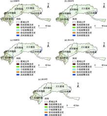
图2
林草植被覆盖度分布"

表3
2000—2019年河套灌区林草植被覆盖度等级转移矩阵"
| FVC等级 | 低 | 较低 | 中 | 较高 | 高 | 转入 |
|---|---|---|---|---|---|---|
| 低 | 111.91 | 58.24 | 7.06 | 1.5 | 0.66 | 342.49 |
| 较低 | 182.67 | 237.46 | 44.39 | 8.25 | 3.05 | 652.75 |
| 中 | 71.14 | 153.32 | 55.92 | 14.68 | 6.42 | 413 |
| 较高 | 15.77 | 37.2 | 23.01 | 10.54 | 7.26 | 143.93 |
| 高 | 6.6 | 12.7 | 10.28 | 7.93 | 11.44 | 95.62 |
| 转出 | 984.38 | 1007.26 | 401.12 | 133.27 | 87.91 |
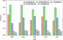
图3
各级林草植被覆盖度占比"

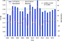
图4
河套灌区林草植被平均FVC变化特征"

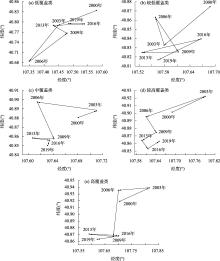
图5
各级植被覆盖度重心迁移"

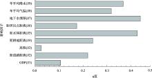
图6
河套灌区林草FVC空间分异驱动因子解释力"

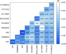
图7
2000—2019年河套灌区各驱动因子交互探测解释力(q)"

表4
驱动因子最适范围"
| 探测因子 | 指标 | 最大FVC均值 | 最适范围 |
|---|---|---|---|
| X1 | 距道路距离 | 0.387 | 10014~13121 m |
| X2 | 距耕地距离 | 0.467 | 1566~2254 m |
| X3 | 距水体距离 | 0.327 | 0~670 m |
| X4 | 距居民点距离 | 0.402 | 7537~11250 m |
| X5 | 地下水埋深 | 0.499 | 1.8~2.8 m |
| X6 | 年平均气温 | 0.351 | 8.9~9.2 ℃ |
| X7 | 年平均降水 | 0.665 | 147~157 mm |
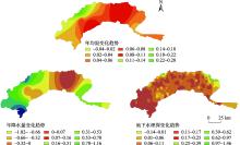
图8
2000—2019年自然因子变化趋势"

| [1] | 陈元鹏, 任佳, 王力. 基于多源遥感数据的生态保护修复项目区监测方法评述[J]. 生态学报, 2019, 39(23): 8789-8797. |
| [Chen Yuanpeng, Ren Jia, Wang Li. Review on monitoring method of ecological conservation and restoration project area based on multi-source remote sensing data[J]. Acta Ecologica Sinica, 2019, 39(23): 8789-8797.] | |
| [2] |
Dragoni D, Schmid H P, Wayson C A, et al. Evidence of increased net ecosystem productivity associated with a longer vegetated season in a deciduous forest in south-central Indiana, USA[J]. Global Change Biology, 2011, 17(2): 886-897.
doi: 10.1111/gcb.2010.17.issue-2 |
| [3] |
Li J, Xu B, Yang X, et al. Historical grassland desertification changes in the Horqin Sandy Land, Northern China (1985-2013)[J]. Scientific Reports, 2017, 7(1): 3009-3018.
doi: 10.1038/s41598-017-03267-x |
| [4] |
Purevdorj T, Tateishi R, Ishiyama T, et al. Relationships between percent vegetation cover and vegetation indices[J]. International Journal of Remote Sensing, 1998, 19(18): 3519-3535.
doi: 10.1080/014311698213795 |
| [5] |
贾坤, 姚云军, 魏香琴, 等. 植被覆盖度遥感估算研究进展[J]. 地球科学进展, 2013, 28(7): 774-782.
doi: 10.11867/j.issn.1001-8166.2013.07.0774 |
|
[Jia Kun, Yao Yunjun, Wei Xiangqin, et al. A review on fractional vegetation cover estimation using remote sensing[J]. Advances in Earth Sciences, 2013, 28(7): 774-782.]
doi: 10.11867/j.issn.1001-8166.2013.07.0774 |
|
| [6] |
Feng H, Zou B, Luo J. Coverage-dependent amplifiers of vegetation change on global water cycle dynamics[J]. Journal of Hydrology, 2017, 550: 220-229.
doi: 10.1016/j.jhydrol.2017.04.056 |
| [7] | 张朔川, 汤军, 高贤君. 秦皇岛市2001—2020年植被覆盖动态变化及预测[J]. 科学技术与工程, 2021, 21(31): 13254-13261. |
| [Zhang Shuochuan, Tang Jun, Gao Xianjun. Dynamic changes and forecast analysis of vegetation coverage in Qinhuangdao from 2001 to 2020[J]. Science Technology and Engineering, 2021, 21(31): 13254-13261.] | |
| [8] | 李晶, 闫星光, 闫萧萧, 等. 基于GEE云平台的黄河流域植被覆盖度时空变化特征[J]. 煤炭学报, 2021, 46(5): 1439-1450. |
| [Li Jing, Yan Xingguang, Yan Xiaoxiao, et al. Temporal and spatial variation characteristic of vegetation coverage in the Yellow River Basin based on GEE cloud platform[J]. Journal of China Coal Society, 2021, 46(5): 1439-1450.] | |
| [9] | 杨辰丛海. 2000—2021年平和县植被覆盖度变化及其地形驱动因子分析[J]. 浙江农业科学, 2021, 62(8): 1625-1628. |
| [Yang Chenconghai. Vegetation coverage change and terrain driving factor analysis of Pinghe County from 2000 to 2021[J]. Journal of Zhejiang Agricultural Sciences, 2021, 62(8): 1625-1628.] | |
| [10] | 郑勇. 川西高原近20年植被覆盖遥感动态监测及驱动力分析[J]. 遥感技术与应用, 2020, 35(6): 1447-1456. |
| [Zheng Yong. Remote sensing dynamic monitoring and driving force analysis of vegetation cover in western Sichuan Plateau in recent 20 years[J]. Remote Sensing Technology and Application, 2020, 35(6): 1447-1456.] | |
| [11] | 王瑾, 闫庆武, 谭学玲, 等. 内蒙古地区植被覆盖动态及驱动因素分析[J]. 林业资源管理, 2019(4): 159-167. |
| [Wang Jin, Yan Qingwu, Tan Xueling, et al. Analysis of vegetation cover dynamics and driving factors in Inner Mongolia[J]. Forest Resources Management, 2019(4): 159-167.] | |
| [12] | 曹永香, 毛东雷, 薛杰, 等. 绿洲-沙漠过渡带植被覆盖动态变化及其驱动因素——以新疆策勒为例[J]. 干旱区研究, 2022, 39(2): 510-521. |
| [Cao Yongxiang, Mao Donglei, Xue Jie, et al. Dynamic changes and driving factors of vegetation cover in the oasis-desert ecotone: A case study of Cele, Xinjiang[J]. Arid Zone Research, 2022, 39(2): 510-521.] | |
| [13] |
张思源, 聂莹, 张海燕, 等. 基于地理探测器的内蒙古植被NDVI时空变化与驱动力分析[J]. 草地学报, 2020, 28(5): 1460-1472.
doi: 10.11733/j.issn.1007-0435.2020.05.034 |
|
[Zhang Siyuan, Nie Ying, Zhang Haiyan, et al. Spatiotemporal variation of vegetation NDVI and its driving forces in Inner Mongolia based on geodetector[J]. Acta Agrestia Sinica, 2020, 28(5): 1460-1472.]
doi: 10.11733/j.issn.1007-0435.2020.05.034 |
|
| [14] | 马晓妮, 任宗萍, 谢梦瑶, 等. 基于地理探测器的砒砂岩区植被覆盖度环境驱动因子量化分析[J]. 生态学报, 2022, 42(8): 3389-3399. |
| [Ma Xiaoni, Ren Zongping, Xie Mengyao, et al. Quantitative analysis of environmental driving factors of vegetation coverage in the Pisha sandstone area based on geodetector[J]. Acta Ecologica Sinica, 2022, 42(8): 3389-3399.] | |
| [15] | 孙微. 陕北地区农牧交错带植被覆盖度动态及驱动力分析[D]. 北京: 北京林业大学, 2012. |
| [Sun Wei. Northern of Shaanxi Province Farming-pastoral Region Vegetation Coverage Dynamic Force Analysis[D]. Beijing: Forestry University, 2012.] | |
| [16] |
王劲峰, 徐成东. 地理探测器原理与展望[J]. 地理学报, 2017, 72(1): 116-134.
doi: 10.11821/dlxb201701010 |
|
[Wang Jinfeng, Xu Chengdong. Geographic detector principle and prospect[J]. Acta Geographica Sinica, 2017, 72(1): 116-134.]
doi: 10.11821/dlxb201701010 |
|
| [17] | 席文涛, 高晶. 基于地理探测器分析青藏高原降水δ18O空间分异特征[J]. 干旱区研究, 2021, 38(5): 1199-1206. |
| [Xi Wentao, Gao Jing. Spatial heterogeneity of annual precipitation δ18O over the Tibetan Plateau based on the use of a geographical detector[J]. Arid Zone Reearch, 2021, 38(5): 1199-1206.] | |
| [18] | 孟琪, 武志涛, 杜自强, 等. 基于地理探测器的区域植被覆盖度的定量影响——以京津风沙源区为例[J]. 中国环境科学, 2021, 41(2): 826-836. |
| [Meng Qi, Wu Zhitao, Du Ziqiang, et al. Quantitative influence of regional fractional vegetation cover based on geodetector model: Take the Beijing-Tianjin sand source region as an example[J]. China Environmental Science, 2021, 41(2): 826-836.] | |
| [19] | 祝聪, 彭文甫, 张丽芳, 等. 2006—2016年岷江上游植被覆盖度时空变化及驱动力[J]. 生态学报, 2019, 39(5): 1583-1594. |
| [Zhu Cong, Peng Wenfu, Zhang Lifang, et al. Study of temporal and spatial variation and driving force of fractional vegetation cover in upper reaches of Minjiang River from 2006 to 2016[J]. Acta Ecologica Sinica, 2019, 39(5): 1583-1594.] | |
| [20] | 高鹏文, 阿里木江·卡斯木, 赵永玉, 等. 1988—2018年哈密绿洲植被覆盖度时空变化及其驱动力[J]. 水土保持通报, 2020, 40(6): 273-280. |
| [Gao Pengwen, Kasim Alimujiang, Zhao Yongyu, et al. Spatial and temporal changes and driving forces of vegetation coverage in Hami Oasis during 1988-2018[J]. Bulletin of Soil and Water Conservation, 2020, 40(6): 273-280.] | |
| [21] | 潘志华, 安萍莉, 刘亚玲, 等. 北方农牧交错带生态系统自然环境变化研究——以武川县为例[J]. 中国农业资源与区划, 2003, 24(5): 41-45. |
| [Pan Zhihua, An Pingli, Liu Yaling, et al. Study on the changes of natural environment in the agro-pastoral ecotone of North China: A case study of Wuchuan County[J]. Chinese Journal of Agricultural Resources and Regional Planning, 2003, 24(5): 41-45.] | |
| [22] | 张亦然. 耦合“空-天”遥感的科尔沁沙丘-草甸相间地区植被覆盖度解译及其时空演变规律[D]. 呼和浩特: 内蒙古农业大学, 2021. |
| [Zhang Yiran. The Interpretation of Vegetation Coverage and Its Temporal and Spatial Evolution in Horqin Dune-Meadow Interphase Area Coupled with “Sky-Sky” Remote Sensing[D]. Hohhot: Inner Mongolia Agricultural University, 2021.] | |
| [23] |
张志强, 刘欢, 左其亭, 等. 2000—2019年黄河流域植被覆盖度时空变化[J]. 资源科学, 2021, 43(4): 849-858.
doi: 10.18402/resci.2021.04.18 |
|
[Zhang Zhiqiang, Liu Huan, Zuo Qiting, et al. Spatiotemporal change of fractional vegetation cover in the Yellow River Basin during 2000-2019[J]. Resource Science, 2021, 43(4): 849-858.]
doi: 10.18402/resci.2021.04.18 |
|
| [24] | 苏丽德, 王海兵, 左合君. 1986—2019年乌拉特后旗荒漠化动态演变及其成因研究[J]. 绿色科技, 2020(12): 1-6. |
| [Su Lide, Wang Haibing, Zuo Hejun. Analysis on the dynamic evolution and causes of desertification in the later period of urat from 1986 to 2019[J]. Journal of Green Science and Technology, 2020(12): 1-6.] | |
| [25] | 梁顺林, 白瑞, 陈晓娜, 等. 2019年中国陆表定量遥感发展综述[J]. 遥感学报, 2020, 24(6): 618-671. |
| [Liang Shunlin, Bai Rui, Chen Xiao’na, et al. Review of China’s land surface quantitative remote sensing development in 2019[J]. National Remote Sensing Bulletin, 2020, 24(6): 618-671.] | |
| [26] | 李苗苗. 植被覆盖度的遥感估算方法研究[D]. 北京: 中国科学院遥感应用研究所, 2003. |
| [Li Miaomiao. Research on Remote Sensing Estimation Method of Vegetation Coverage[D]. Beijing: Institute of Remote Sensing Application, Chinese Academy of Sciences, 2003.] | |
| [27] | 中华人民共和国水利行业标准. SL 190-2007土壤侵蚀分类分级标准[S]. 北京: 中华人民共和国水利部, 北京: 中华人民共和国水利部, 2008. |
| [Water Industry Standard of the People’s Republic of China. SL 190-2007 Standard for Classification and Classification of Soil Erosion[S]. Beijing: Ministry of Water Resources of the People’s Republic of China, 2008.] | |
| [28] | 王娟, 李宝林, 余万里. 近30年内蒙古自治区植被变化趋势及影响因素分析[J]. 干旱区资源与环境, 2012, 26(2): 132-138. |
| [Wang Juan, Li Baolin, Yu Wanli. Analysis of vegetation trend and their causes during recent 30 years in Inner Mongolia Autonomous Region[J]. Journal of Arid Land Resources and Environment, 2012, 26(2): 132-138.] | |
| [29] | 高宇婷, 于洋, 孙凌霄, 等. 塔里木盆地南缘绿洲土地覆盖变化及驱动力[J]. 干旱区研究, 2021, 38(4): 1172-1183. |
| [Gao Yuting, Yu Yang, Sun Lingxiao, et al. Land coverage change and driving forces of an oasis in the southern margin of Tarim Basin[J]. Arid Zone Research, 2021, 38(4): 1172-1183.] | |
| [30] | 曹翊坤, 付梅臣, 谢苗苗, 等. 基于LSMM与MSPA的深圳市绿色景观连通性研究[J]. 生态学报, 2015, 35(2): 526-536. |
| [Cao Yikun, Fu Meichen, Xie Miaomiao, et al. Landscape connectivity dynamics of urban green landscape based on morphological spatial pattern analysis(MSPA) and linear spectral mixture model (LSMM) in Shenzhen[J]. Acta Ecologica Sinica, 2015, 35(2): 526-536.] | |
| [31] | 闫晋阳, 马向阳, 王晨霞. 河套灌区国管水利工程保护与管理问题分析及对策建议[J]. 中国水利, 2021(15): 58-59. |
| [Yan Jinyang, Ma Xiangyang, Wang Chenxia. Analysis and countermeasures on protection and management of water conservancy projects in Hetao Irrigation District[J]. China Water Resources, 2021(15): 58-59.] | |
| [32] | 李茂林, 闫庆武, 仲晓雅, 等. 干旱半干旱地区植被覆盖度变化及主导因素分析:以锡林郭勒为例[J]. 生态与农村环境学报, 2021, 37(12): 1548-1558. |
| [Li Maolin, Yan Qingwu, Zhong Xiaoya, et al. Analysis on evolution and dominant factors of fractional vegetation coverage in arid and semi-arid regions: A case of Xilingol[J]. Journal of Ecology and Rural Environment, 2021, 37(12): 1548-1558.] | |
| [33] |
陈效逑, 王恒. 1982—2003年内蒙古植被带和植被覆盖度的时空变化[J]. 地理学报, 2009, 64(1): 84-94.
doi: 10.11821/xb200901009 |
|
[Chen Xiaoqiu, Wang Heng. Spatial and temporal variations of vegetation belts and vegetation cover degrees in Inner Mongolia from 1982 to 2003[J]. Acta Geographica Sinica, 2009, 64(1): 84-94.]
doi: 10.11821/xb200901009 |
| [1] | 刘一丹, 姚晓军, 李宗省, 胡家瑜. 气候变化和土地利用覆盖变化对河西地区植被净初级生产力的影响[J]. 干旱区研究, 2024, 41(1): 169-180. |
| [2] | 文妙霞, 何学高, 刘欢, 张婧, 罗晨, 贾丰铭, 王义贵, 胡云云. 基于地理探测器的宁夏草地植被覆被时空分异及驱动因子[J]. 干旱区研究, 2023, 40(8): 1322-1332. |
| [3] | 李虹, 李忠勤, 陈普晨, 彭加加. 近20 a新疆阿尔泰山积雪时空变化及其影响因素[J]. 干旱区研究, 2023, 40(7): 1040-1051. |
| [4] | 王士维, 孙栋元, 周敏, 王亦可, 王祥镔, 季宗虎, 张文睿, 武兰珍. 1951—2020年疏勒河流域气温时空变化特征[J]. 干旱区研究, 2023, 40(7): 1065-1074. |
| [5] | 赵卓怡, 郝兴明. 基于Priestley-Taylor方法的中亚干旱区实际蒸散特征及归因[J]. 干旱区研究, 2023, 40(7): 1085-1093. |
| [6] | 齐润泽, 潘竟虎. 河湟地区生态脆弱性时空演变及影响因素研究[J]. 干旱区研究, 2023, 40(6): 1002-1013. |
| [7] | 刘笑, 郭鹏, 祁佳峰, 杜文玲, 张茹倩, 张坤. 基于MRSEI模型的阿勒泰市生态环境时空变化及驱动力分析[J]. 干旱区研究, 2023, 40(6): 1014-1026. |
| [8] | 薛一波, 张小啸, 雷加强, 李生宇, 王永东, 尤源. 北非埃及地区风蚀沙尘时空变化研究[J]. 干旱区研究, 2023, 40(6): 896-904. |
| [9] | 任丽雯, 王兴涛, 刘明春, 王大为. 石羊河流域植被净初级生产力时空变化及驱动因素[J]. 干旱区研究, 2023, 40(5): 818-828. |
| [10] | 吕锦心, 梁康, 刘昌明, 张仪辉, 刘璐. 无定河流域土地覆被空间分异机制及相关水碳变量变化[J]. 干旱区研究, 2023, 40(4): 563-572. |
| [11] | 康利刚, 曹生奎, 曹广超, 杨羽帆, 严莉, 王有财. 青海湖沙柳河流域蒸散发时空变化特征[J]. 干旱区研究, 2023, 40(3): 358-372. |
| [12] | 马浩文, 王永芳, 郭恩亮. 基于GEE的翁牛特旗土地沙漠化遥感监测[J]. 干旱区研究, 2023, 40(3): 504-516. |
| [13] | 孙贯芳,高照良,朱焱,杨金忠,屈忠义. 时空克里金评估河套灌区土壤盐分时空格局[J]. 干旱区研究, 2023, 40(2): 182-193. |
| [14] | 徐涛,于欢,孔博,邱霞,胡孟珂,凌鹏飞. 藏北高原砾石粒径空间异质性研究[J]. 干旱区研究, 2023, 40(2): 292-302. |
| [15] | 许丽婷,刘海红,黄丽洁,王钰帆. 2000—2020年汾河流域生态环境与水源涵养时空变化[J]. 干旱区研究, 2023, 40(2): 313-325. |
|
||