干旱区研究 ›› 2023, Vol. 40 ›› Issue (2): 292-302.doi: 10.13866/j.azr.2023.02.13
徐涛1( ),于欢1(),孔博2,邱霞1,3,胡孟珂1,凌鹏飞1
收稿日期:2022-07-09
修回日期:2022-11-27
出版日期:2023-02-15
发布日期:2023-03-08
通讯作者:
于欢
作者简介:徐涛(1996-),男,硕士研究生,生态地理信息系统. E-mail: 基金资助:
XU Tao1(),YU Huan1(),KONG Bo2,QIU Xia1,3,HU Mengke1,LING Pengfei1
Received:2022-07-09
Revised:2022-11-27
Online:2023-02-15
Published:2023-03-08
Contact:
Huan YU
摘要:
砾石是各种水文和侵蚀等过程综合作用的产物,是草地和土壤退化、生态系统恶化的一个标志,反过来这些砾石也影响到侵蚀的各个过程。研究藏北高原地表砾石的空间分异对区域生态环境恢复具有重要意义。本文以地表砾石粒径大小和空间位置为研究对象,通过Moran’s I指数、空间变异函数、地理探测器、回归分析等方法对其空间异质性进行系统性分析。结果表明:(1) 全局Moran’s I指数值为0.481,呈显著的正相关,局部Moran’s I指数显示,研究区东部砾石聚集模式为高-高聚集,中部为低-低聚集,其余区域多呈随机分布。(2) 砾石空间异质性由结构因素主导,但是变异函数最佳拟合模型与特征参数值均存在一定差异性,即存在一定的各向异性特征。(3) 地理探测器结果显示,NDVI、土地利用类型为影响研究区砾石粒径空间异质性的主要因素,人口密度、植被类型、年均降水为次要因素。(4) 回归分析结果显示,最优尺度回归为最佳回归模型,NDVI对砾石粒径影响最大,其后依次为土地利用类型、年均降水、植被类型。
徐涛,于欢,孔博,邱霞,胡孟珂,凌鹏飞. 藏北高原砾石粒径空间异质性研究[J]. 干旱区研究, 2023, 40(2): 292-302.
XU Tao,YU Huan,KONG Bo,QIU Xia,HU Mengke,LING Pengfei. Spatial heterogeneity of gravel size in Northern Tibetan Plateau[J]. Arid Zone Research, 2023, 40(2): 292-302.
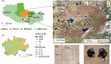
图1
野外采样与反演成果 注:底图采用自然资源部标准地图制作,审图号为GS(2019)3333号,对底图边界无修改。下同。"

表1
数据来源及介绍"
| 数据类型 | 数据名称 | 数据来源 | 分辨率 |
|---|---|---|---|
| 自然因素 | DEM(X1) | 国家地球系统科学数据中心(http:www.geodata.cn) | 30 m |
| 年NDVI(X2) | 中国科学院资源环境科学与数据中心(http:www.resdc.cn) | 1000 m | |
| 土地利用类型(X3) | 国家地球系统科学数据中心(http:www.geodata.cn) | 30 m | |
| 土壤类型(X4) | 国家地球系统科学数据中心(http:www.geodata.cn) | 1000 m | |
| 植被类型(X5) | 中国科学院资源环境科学与数据中心(http:www.resdc.cn) | 1000 m | |
| 年均降水(X6) | 中国科学院资源环境科学与数据中心(http:www.resdc.cn) | 500 m | |
| 人文因素 | 人口密度(X7) | 中国科学院资源环境科学与数据中心(http:www.resdc.cn) | 100 m |
| 夜间灯光强度(X8) | 美国国家地球物理数据中心(https:www.ngdc.noaa.gov) | 500 m |
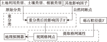
图2
数据处理流程"

图3
研究区砾石粒径的空间聚集特征"

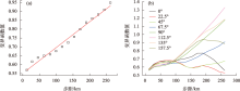
图4
砾石粒径空间变异曲线"

表2
砾石粒径空间变异函数特征参数"
| 方向 | 块金值(C0) | 偏基台值(C) | 块基比(C0/C0+C) | 变程(a)/km | 决定系数(R2) | |
|---|---|---|---|---|---|---|
| 各向同性 | - | 0.391 | 0.708 | 0.356 | 26.178 | 0.981 |
| 各向异性 | 0° | 0.537 | 1.185 | 0.312 | 69.500 | 0.500 |
| 22.5° | 0.534 | 1.330 | 0.286 | 76.500 | 0.788 | |
| 45° | 0.539 | 1.195 | 0.311 | 69.500 | 0.585 | |
| 67.5° | 0.544 | 1.234 | 0.306 | 90.420 | 0.802 | |
| 90° | 0.617 | 1.203 | 0.339 | 62.840 | 0.505 | |
| 112.5° | 0.606 | 1.347 | 0.310 | 70.240 | 0.833 | |
| 135° | 0.601 | 1.195 | 0.335 | 64.360 | 0.509 | |
| 157.5° | 0.555 | 1.503 | 0.270 | 110.000 | 0.801 |
表3
砾石粒径因子探测结果"
| DEM(X1) | 年NDVI(X2) | 土地利用类型(X3) | 土壤类型(X4) | 植被类型(X5) | 年均降水(X6) | 人口密度(X7) | 夜间灯光强度(X8) | |
|---|---|---|---|---|---|---|---|---|
| q值 | 0.11 | 0.41 | 0.27 | 0.17 | 0.15 | 0.13 | 0.16 | 0.02 |
| P值 | 0.35 | 0.00 | 0.00 | 0.99 | 0.00 | 0.00 | 0.00 | 1.00 |
表4
砾石粒径影响因子间交互作用"
| C | A+B | 结果 | 解释 |
|---|---|---|---|
| X2∩X3=0.56 | X2(0.41)+X3(0.27) | C >max(A,B) | 双因子增强 |
| X2∩X5=0.46 | X2(0.41)+X5(0.17) | C >max(A,B) | 双因子增强 |
| X2∩X6=0.46 | X2(0.41)+X6(0.13) | C >max(A,B) | 双因子增强 |
| X2∩X7=0.47 | X2(0.41)+X7(0.16) | C >max(A,B) | 双因子增强 |
| X3∩X5=0.42 | X3(0.27)+X5(0.17) | C >max(A,B) | 双因子增强 |
| X3∩X6=0.47 | X3(0.27)+X6(0.13) | C>A+B | 非线性增强 |
| X3∩X7=0.39 | X3(0.27)+X7(0.16) | C >max(A,B) | 双因子增强 |
| X5∩X6=0.28 | X5(0.17)+X6(0.13) | C >max(A,B) | 双因子增强 |
| X5∩X7=0.26 | X5(0.17)+X7(0.16) | C >max(A,B) | 双因子增强 |
| X6∩X7=0.27 | X6(0.13)+X7(0.16) | C >max(A,B) | 双因子增强 |
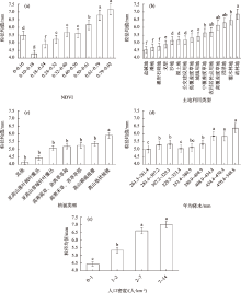
图5
影响因子分区粒径大小 注:不同小写字母表示不同分区之间存在显著差异(P<0.05)。"
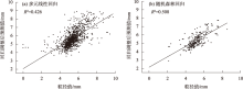
图6
多元线性回归与随机森林回归拟合"

表5
最优尺度回归模型"
| 标准化系数 | 显著性 | 改进后标 准化系数 | 改进后 显著性 | |
|---|---|---|---|---|
| NDVI | 0.530 | 0.000 | 0.578 | 0.000 |
| 土地利用类型 | 0.313 | 0.000 | 0.308 | 0.000 |
| 年均降水 | 0.084 | 0.003 | 0.102 | 0.003 |
| 植被类型 | 0.070 | 0.000 | 0.064 | 0.000 |
| 人口密度 | -0.044 | 0.212 | - | - |

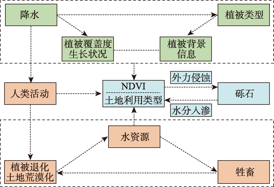
图7
环境变量对砾石粒径的影响机制"
| [1] | 王景升, 姚帅臣, 普穷, 等. 藏北高原草地群落的数量分类与排序[J]. 生态学报, 2016, 36(21): 6889-6896. |
| [Wang Jingsheng, Yao Shuaichen, Pu Qiong, et al. Quantitative classification and ordination of grassland communities in northern Tibetan Plateau[J]. Acta Ecologica Sinica, 2016, 36(21): 6889-6896.] | |
| [2] |
王景升, 张宪洲, 赵玉萍, 等. 羌塘高原高寒草地生态系统生产力动态[J]. 应用生态学报, 2010, 21(6): 1400-1404.
pmid: 20873612 |
|
[Wang Jingsheng, Zhang Xianzhou, Zhao Yuping, et al. Productivity dynamics of alpine grassland ecosystem on the Qiangtang Plateau[J]. Chinese Journal of Applied Ecology, 2010, 21(6): 1400-1404.]
pmid: 20873612 |
|
| [3] | 水宏伟, 干珠扎布, 吴红宝, 等. 禁牧对藏北高原狼毒型退化草地群落特征及生产力的影响[J]. 草业学报, 2020, 29(10): 14-21. |
| [Shui Hongwei, Gan Zhuzhabu, Wu Hongbao, et al. Effects of grazing prohibition on community characteristics and productivity of degraded grassland with wolfsbane in northern Tibetan Plateau[J]. Acta Prataculturae Sinica, 2020, 29(10): 14-21.] | |
| [4] | 张宪洲, 王小丹, 高清竹, 等. 开展高寒退化生态系统恢复与重建技术研究, 助力西藏生态安全屏障保护与建设[J]. 生态学报, 2016, 36(22): 7083-7087. |
| [Zhang Xianzhou, Wang Xiaodan, Gao Qingzhu, et al. Research on the restoration and reconstruction of degraded alpine ecosystems has been carried out to help protect and build an ecological safety barrier in Tibet[J]. Acta Ecologica Sinica, 2016, 36(22): 7083-7087.] | |
| [5] | 郝爱华, 薛娴, 彭飞, 等. 青藏高原典型草地植被退化与土壤退化研究[J]. 生态学报, 2020, 40(3): 964-975. |
| [Hao Aihua, Xue Xian, Peng Fei, et al. Study on vegetation degradation and soil degradation of typical grassland on the Qinghai-Tibet Plateau[J]. Acta Ecologica Sinica, 2020, 40(3): 964-975.] | |
| [6] | Li G Y, Mu J P, Liu Y Z, et al. Effect of microtopography on soil respiration in an alpine meadow of the Qinghai-Tibetan plateau[J]. Plant and Soil, 2017, 421: 10.1007/s11104-017-3448-x. |
| [7] |
孙建, 王毅, 刘国华. 青藏高原高寒草地地上植物碳积累速率对生态系统多功能性的影响机制[J]. 植物生态学报, 2021, 45(5): 496-506.
doi: 10.17521/cjpe.2020.0180 |
|
[Sun Jian, Wang Yi, Liu Guohua. The effect mechanism of carbon accumulation rate of above-ground plants on the multifunctionality of ecosystem in alpine grassland of Qinghai-Tibet Plateau[J]. Chinese Journal of Plant Ecology, 2021, 45(5): 496-506.]
doi: 10.17521/cjpe.2020.0180 |
|
| [8] | 魏宁, 于文竹, 安克俭, 等. 青藏高原高寒草原与草甸土壤可蚀性的关键因子[J]. 水土保持通报, 2021, 41(3): 87-93, 102. |
| [Wei Ning, Yu Wenzhu, An Kejian, et al. The key factors of soil erodibility of alpine grasslands and meadows on the Qinghai-Tibet Plateau[J]. Bulletin of Soil and Water Conservation, 2021, 41(3): 87-93, 102.] | |
| [9] | Wang Q F, Jin H J, Zhang T J, et al. Hydro-thermal processes and thermal offsets of peat soils in the active layer in an alpine permafrost region, NE Qinghai-Tibet plateau[J]. Elsevier, 2017, 156(56): 1-12. |
| [10] |
Xiao P P, Zheng G G. Plateau pika disturbances alter plant productivity and soil nutrients in alpine meadows of the Qinghai-Tibetan Plateau, China[J]. The Rangeland Journal, 2017, 39(2): 133-144.
doi: 10.1071/RJ16093 |
| [11] | 高杨, 符素华, 罗来军, 等. 砾石覆盖度测量方法研究[J]. 水土保持通报, 2013, 33(4): 264-267, 270. |
| [Gao Yang, Fu Suhua, Luo Laijun, et al. Study on measuring method of gravel coverage[J]. Bulletin of Soil and Water Conservation, 2013, 33(4): 264-267, 270.] | |
| [12] |
Okin G S, Painter T H. Effect of grain size on remotely sensed spectral reflectance of sandy desert surfaces[J]. Remote Sensing of Environment, 2004, 89(3): 272-280.
doi: 10.1016/j.rse.2003.10.008 |
| [13] | 董玉祥, Namikas S L, Hesp P A. 海岸风沙流中不同粒径组沙粒的垂向分布模式[J]. 地理研究, 2009, 28(5): 1179-1187. |
| [Dong Yuxiang, Namikas S L, Hesp P A. Vertical distribution patterns of sand particles of different particle sizes in the coastal sand flow[J]. Geographical Research, 2009, 28(5): 1179-1187.] | |
| [14] |
陈西庆, 严以新, 童朝锋, 等. 长江输入河口段床沙粒径的变化及机制研究[J]. 自然科学进展, 2007, 17(2): 233-239.
doi: 10.1080/10020070612331343253 |
|
[Chen Xiqing, Yan Yixin, Tong Chaofeng, et al. Study on the change and mechanism of bed sand particle size in the estuary section of the Yangtze River[J]. Progress in Natural Science, 2007, 17(2): 233-239.]
doi: 10.1080/10020070612331343253 |
|
| [15] |
Quade J. Desert pavements and associated rock varnish in the Mojave Desert: How old can they be?[J]. Geology, 2015, 29(9): 855-858.
doi: 10.1130/0091-7613(2001)029<0855:DPAARV>2.0.CO;2 |
| [16] | 曹晓阳, 冯益明. 噶顺戈壁地表砾石粒度特征分析[J]. 中国水土保持科学, 2016, 14(1): 46-52. |
| [Cao Xiaoyang, Feng Yiming. Analysis of surface gravel grain size characteristics in Gaishun Gobi[J]. Science of Soil and Water Conservation, 2016, 14(1): 46-52.] | |
| [17] | 王利兵, 胡小龙, 余伟莅, 等. 沙粒粒径组成的空间异质性及其与灌丛大小和土壤风蚀相关性分析[J]. 干旱区地理, 2006, 29(5): 688-693. |
| [Wang Libing, Hu Xiaolong, Yu Weili, et al. Spatial heterogeneity of sand particle size composition and its correlation with shrub size and soil wind erosion[J]. Arid Land Geography, 2006, 29(5): 688-693.] | |
| [18] | Shrestha A, Luo W. Analysis of groundwater nitrate contamina-tion in the Central Valley: Comparison of the geodetector method, principal component analysis and geographically weighted regres-sion[J]. International Journal of Geo-Information, 2017, 6(10): 297. |
| [19] | 邱霞. 那曲南部地区砾石特征参数空间分布规律研究[D]. 成都: 成都理工大学, 2021. |
| [Qiu Xia. Research on the Spatial Distribution Law of Gravel Characteristic Parameters in Southern Naqu. Master Thesis[D]. Chengdu: Chengdu University of Technology, 2021.] | |
| [20] |
Wentworth C K. A Scale of Grade and Class Terms for Clastic Sediments[J]. The Journal of Geology, 1922, 30(5): 377-392.
doi: 10.1086/622910 |
| [21] | 裴志林, 杨勤科, 王春梅, 等. 黄河上游植被覆盖度空间分布特征及其影响因素[J]. 干旱区研究, 2019, 36(3): 546-555. |
| [Pei Zhilin, Yang Qinke, Wang Chunmei, et al. Spatial distribution characteristics and influencing factors of vegetation coverage in the upper reaches of the Yellow River[J]. Arid Zone Research, 2019, 36(3): 546-555.] | |
| [22] |
文琦, 施琳娜, 马彩虹, 等. 黄土高原村域多维贫困空间异质性研究——以宁夏彭阳县为例[J]. 地理学报, 2018, 73(10): 1850-1864.
doi: 10.11821/dlxb201810003 |
|
[Wen Qi, Shi Linna, Ma Caihong, et al. Research on the spatial heterogeneity of multidimensional poverty in the villages of the Loess Plateau: A case study of Pengyang County, Ningxia[J]. Acta Geographica Sinica, 2018, 73(10): 1850-1864.]
doi: 10.11821/dlxb201810003 |
|
| [23] | 鲁迪, 钱宏胜, 赵鹏飞, 等. 河南省区域城市化与生态环境效应空间关系分析[J]. 信阳师范学院学报(自然科学版), 2015, 28(3): 377-381. |
| [Lu Di, Qian Hongsheng, Zhao Pengfei, et al. Analysis of spatial relationship between regional urbanization and ecological environment effects in Henan Province[J]. Journal of Xinyang Normal University (Natural Science Edition), 2015, 28(3): 377-381.] | |
| [24] |
孙志虎, 牟长城, 孙龙. 采用地统计学方法对落叶松人工纯林表层细根生物量的估计[J]. 植物生态学报, 2006, 30(5): 771-779.
doi: 10.17521/cjpe.2006.0099 |
|
[Sun Zhihu, Mou Changcheng, Sun Long. Estimation of surface fine root biomass of pure larch plantations using geostatistics methods[J]. Chinese Journal of Plant Ecology, 2006, 30(5): 771-779.]
doi: 10.17521/cjpe.2006.0099 |
|
| [25] |
杨忍, 刘彦随, 龙花楼, 等. 基于格网的农村居民点用地时空特征及空间指向性的地理要素识别: 以环渤海地区为例[J]. 地理研究, 2015, 34(6): 1077-1087.
doi: 10.11821/dlyj201506007 |
|
[Yang Ren, Liu Yansui, Long Hualou, et al. Recognition of geographic elements based on grid-based spatial and temporal characteristics and spatial directivity of rural residential land use: A case study of the Bohai Rim region[J]. Geographical Research, 2015, 34(6): 1077-1087.]
doi: 10.11821/dlyj201506007 |
|
| [26] |
Wang J F, Zhang T L, Fu B J. A measure of spatial stratified heterogeneity[J]. Ecological Indicators, 2016, 67: 250-256.
doi: 10.1016/j.ecolind.2016.02.052 |
| [1] | 齐润泽, 潘竟虎. 河湟地区生态脆弱性时空演变及影响因素研究[J]. 干旱区研究, 2023, 40(6): 1002-1013. |
| [2] | 刘笑, 郭鹏, 祁佳峰, 杜文玲, 张茹倩, 张坤. 基于MRSEI模型的阿勒泰市生态环境时空变化及驱动力分析[J]. 干旱区研究, 2023, 40(6): 1014-1026. |
| [3] | 李鑫磊, 李瑞平, 王秀青, 王思楠, 王成坤. 基于地理探测器的河套灌区林草植被覆盖度时空变化与驱动力分析[J]. 干旱区研究, 2023, 40(4): 623-635. |
| [4] | 吕锦心, 梁康, 刘昌明, 张仪辉, 刘璐. 无定河流域土地覆被空间分异机制及相关水碳变量变化[J]. 干旱区研究, 2023, 40(4): 563-572. |
| [5] | 马浩文, 王永芳, 郭恩亮. 基于GEE的翁牛特旗土地沙漠化遥感监测[J]. 干旱区研究, 2023, 40(3): 504-516. |
| [6] | 贺军奇,拜寒伟,徐轶玮,倪莉莉. 陕西黄土区农田土壤主要养分特征及影响因素[J]. 干旱区研究, 2023, 40(12): 1907-1917. |
| [7] | 侯文兵, 李开明, 黄卓. 近20 a河西地区绿洲效应时空变化特征及归因分析[J]. 干旱区研究, 2023, 40(12): 2031-2042. |
| [8] | 吴雪晴, 张乐乐, 高黎明, 李炎坤, 刘轩辰. 青海湖流域NPP动态变化及驱动力[J]. 干旱区研究, 2023, 40(11): 1824-1832. |
| [9] | 裴宏泽, 赵亚超, 张廷龙. 2000—2020年黄土高原NEP时空格局与驱动力[J]. 干旱区研究, 2023, 40(11): 1833-1844. |
| [10] | 赵蒙恩,闫庆武,刘政婷,王文铭,李桂娥,吴振华. 鄂尔多斯市土壤侵蚀时空演变及影响因子分析[J]. 干旱区研究, 2022, 39(6): 1819-1831. |
| [11] | 王琦琨,武玮,杨雪琪,桑国庆. 陕西省生境质量时空演变及驱动机制分析[J]. 干旱区研究, 2022, 39(5): 1684-1694. |
| [12] | 贺静,吉力力·阿不都外力,马龙. 锡尔河流域哈萨克斯坦境内农田土壤粒度特征及空间异质性[J]. 干旱区研究, 2022, 39(4): 1282-1292. |
| [13] | 排日海·合力力,昝梅,阿里木江·卡斯木. 乌鲁木齐市生态环境遥感评价及驱动因子分析[J]. 干旱区研究, 2021, 38(5): 1484-1496. |
| [14] | 闫晋升,王永东,娄泊远,艾柯代·艾斯凯尔,徐新文. 哈萨克斯坦首都努尔苏丹人工林健康评价[J]. 干旱区研究, 2021, 38(5): 1474-1483. |
| [15] | 席文涛,高晶. 基于地理探测器分析青藏高原降水δ18O空间分异特征[J]. 干旱区研究, 2021, 38(5): 1199-1206. |
|
||