干旱区研究 ›› 2023, Vol. 40 ›› Issue (6): 1002-1013.doi: 10.13866/j.azr.2023.06.15
齐润泽( ),潘竟虎()
收稿日期:2022-10-26
修回日期:2023-03-09
出版日期:2023-06-15
发布日期:2023-06-21
通讯作者:
潘竟虎. E-mail: 作者简介:齐润泽(1996-),男,硕士研究生,主要从事生态环境遥感研究. E-mail: 基金资助:
QI Runze(),PAN Jinghu()
Received:2022-10-26
Revised:2023-03-09
Online:2023-06-15
Published:2023-06-21
摘要:
基于暴露度-敏感性-适应力生态脆弱性概念模型构建评价指标体系,利用投影寻踪模型和遗传算法确定指标权重,计算了河湟地区生态脆弱性指数,采用时空扫描探究生态脆弱性空间聚集特征及时空变化规律,借助地理探测器研究生态脆弱性的影响因素。结果表明:2000—2020年河湟地区生态脆弱性以轻度脆弱与中度脆弱为主,空间分布存在明显的地域差异。生态脆弱性存在明显的时间聚集性与局部的空间聚集特征,高值集聚与低值集聚共存,空间集聚主要分布于甘肃省境内。2000—2020年生态脆弱度整体呈降低趋势,53.36%的土地生态脆弱性有所降低。对生态脆弱性影响最大的因子是植被覆盖度,其次是沙漠化指数、植被净初级生产力、干旱指数、生境质量指数、海拔等。
齐润泽, 潘竟虎. 河湟地区生态脆弱性时空演变及影响因素研究[J]. 干旱区研究, 2023, 40(6): 1002-1013.
QI Runze, PAN Jinghu. Spatial and temporal evolution of ecological vulnerability and its influencing factors in the Hehuang area[J]. Arid Zone Research, 2023, 40(6): 1002-1013.

图1
研究区位置示意图"

表1
河湟地区生态脆弱性评价指标体系"
| 子目标层 | 要素层 | 指标层 | ||||||
|---|---|---|---|---|---|---|---|---|
| 编号 | 内容 | 编号 | 内容 | 编号 | 内容 | 作用方向 | ||
| A1 | 暴露度 | B1 | 生态胁迫 | C1 | 干旱指数 | 正向 | ||
| C2 | 水土流失指数 | 正向 | ||||||
| C3 | 沙漠化指数 | 正向 | ||||||
| B2 | 人类干扰 | C4 | 人口密度 | 正向 | ||||
| C5 | 夜间灯光强度 | 正向 | ||||||
| C6 | 土地利用强度 | 正向 | ||||||
| A2 | 敏感性 | B3 | 地表因子 | C7 | 土壤有机质含量 | 负向 | ||
| C8 | 景观多样性 | 负向 | ||||||
| C9 | 景观破碎度 | 正向 | ||||||
| B4 | 地形因子 | C10 | 海拔 | 正向 | ||||
| C11 | 坡度 | 正向 | ||||||
| B5 | 气象因子 | C12 | 年均气温 | 正向 | ||||
| C13 | 年降水量 | 负向 | ||||||
| A3 | 适应力 | B6 | 自我调节 | C14 | 植被净初级生产力 | 负向 | ||
| C15 | 植被覆盖度 | 负向 | ||||||
| B7 | 环保措施 | C16 | 生境质量指数 | 负向 | ||||
表2
生态脆弱性各评价指标权重"
| 评价指标 | 2000年 | 2005年 | 2010年 | 2015年 | 2020年 |
|---|---|---|---|---|---|
| 干旱指数 | 0.2298 | 0.2762 | 0.2695 | 0.2501 | 0.2590 |
| 水土流失指数 | 0.1572 | 0.2238 | 0.1935 | 0.2367 | 0.1868 |
| 沙漠化指数 | 0.2649 | 0.2584 | 0.2525 | 0.2883 | 0.2689 |
| 人口密度 | 0.2061 | 0.2165 | 0.2144 | 0.2083 | 0.2299 |
| 夜间灯光强度 | 0.2582 | 0.2434 | 0.2617 | 0.2459 | 0.2681 |
| 用地强度 | 0.2415 | 0.2652 | 0.2603 | 0.2633 | 0.2753 |
| 土壤有机质含量 | 0.1884 | 0.1723 | 0.1837 | 0.1864 | 0.1874 |
| 景观多样性 | 0.2738 | 0.2453 | 0.2263 | 0.2376 | 0.2265 |
| 景观破碎度 | 0.2476 | 0.2452 | 0.2441 | 0.2514 | 0.2348 |
| 海拔 | 0.2783 | 0.2657 | 0.2733 | 0.2679 | 0.2766 |
| 坡度 | 0.1812 | 0.1774 | 0.1814 | 0.1764 | 0.1899 |
| 年均气温 | 0.2922 | 0.3165 | 0.3092 | 0.2904 | 0.2890 |
| 年降水量 | 0.2026 | 0.2275 | 0.2062 | 0.2104 | 0.2092 |
| 植被净初级生产力 | 0.2653 | 0.2382 | 0.2513 | 0.2466 | 0.2433 |
| 植被覆盖度 | 0.2406 | 0.2731 | 0.2886 | 0.2709 | 0.2766 |
| 生境质量指数 | 0.3332 | 0.3084 | 0.3275 | 0.3241 | 0.3295 |
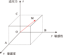
图2
空间向量模型示意图"

表3
河湟地区生态脆弱性分级标准"
| 生态脆弱性程度 | 等级 | 生态脆弱性指数标准化值 | 特征 |
|---|---|---|---|
| 微度脆弱 | Ⅰ | [0, 2.0] | 区域内植被茂盛,承受压力小,抗外界干扰能力和自我恢复能力强,生态脆弱性低 |
| 轻度脆弱 | Ⅱ | (2.0, 4.0] | 区域内植被覆盖度适中,承受压力较小,抗外界干扰能力和自我恢复能力较强,生态脆弱性较低 |
| 中度脆弱 | Ⅲ | (4.0, 6.0] | 区域内植被较少,承受压力接近生态阈值,对外界干扰较为敏感,自我恢复能力较弱,生态脆弱性较高 |
| 重度脆弱 | Ⅳ | (6.0, 8.0] | 区域内植被稀疏,承受压力大,对外界干扰敏感性强,受损后恢复难度大,生态脆弱性高 |
| 极度脆弱 | Ⅴ | (8.0, 10.0] | 区域内植被稀少甚至没有,承受压力极大,对外界干扰极度敏感,受损后恢复难度极大,生态脆弱性极高 |
表4
生态脆弱性格局演变分类"
| 整体转换类型 | 转换编码 | 分类依据 |
|---|---|---|
| 持续稳定型 | 111、222、333、444、555 | 2000年、2010年和2020年间的生态脆弱性等级值须保持相等 |
| 波动稳定型 | 121、131、141、212、232、242、252、313、323、343、353、414、424、434、454、535、545 | 2000年与2020年的生态脆弱性等级值须相等,2010年生态脆弱性等级值可增加或减少,也可以保持不动 |
| 持续增长型 | 123、234、235、345 | 2000年、2010年和2020年间的生态脆弱性等级值须呈现增加趋势 |
| 波动增长型 | 112、113、114、122、132、133、144、142、213、214、215、223、224、225、233、243、244、254、314、315、324、325、334、335、344、425、435、445、455 | 2020年生态脆弱性等级值须高于2000年,2010年生态脆弱性等级值可增加或减少,也可以保持不变 |
| 持续减少型 | 543、542、541、532、432、431、421、321、 | 2000年、2010年和2020年间的生态脆弱性等级值须呈递减趋势 |
| 波动减少型 | 554、553、552、544、534、533、523、453、452、443、442、441、433、423、422、413、411、352、342、341、332、331、322、312、311、251、241、231、221、211 | 2020年生态脆弱性等级值须低于2000年,2010年生态脆弱性等级值可增加或减少,也可以保持不变 |
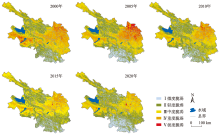
图3
2000—2020年河湟地区生态脆弱性空间分布格局"

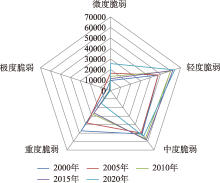
图4
河湟地区生态脆弱性面积变化雷达图"
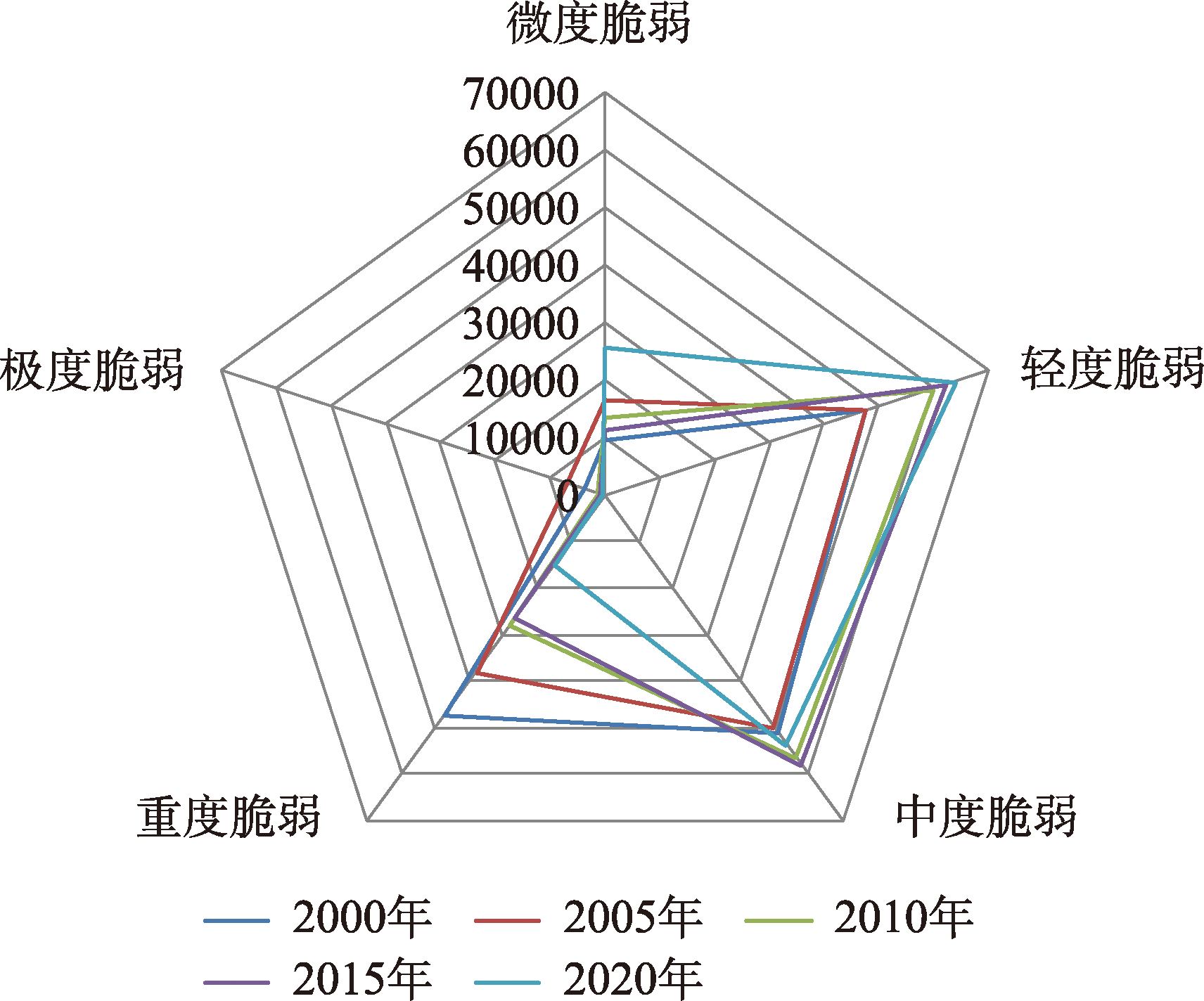

图5
2000—2020年河湟地区生态脆弱性时空扫描结果分布"
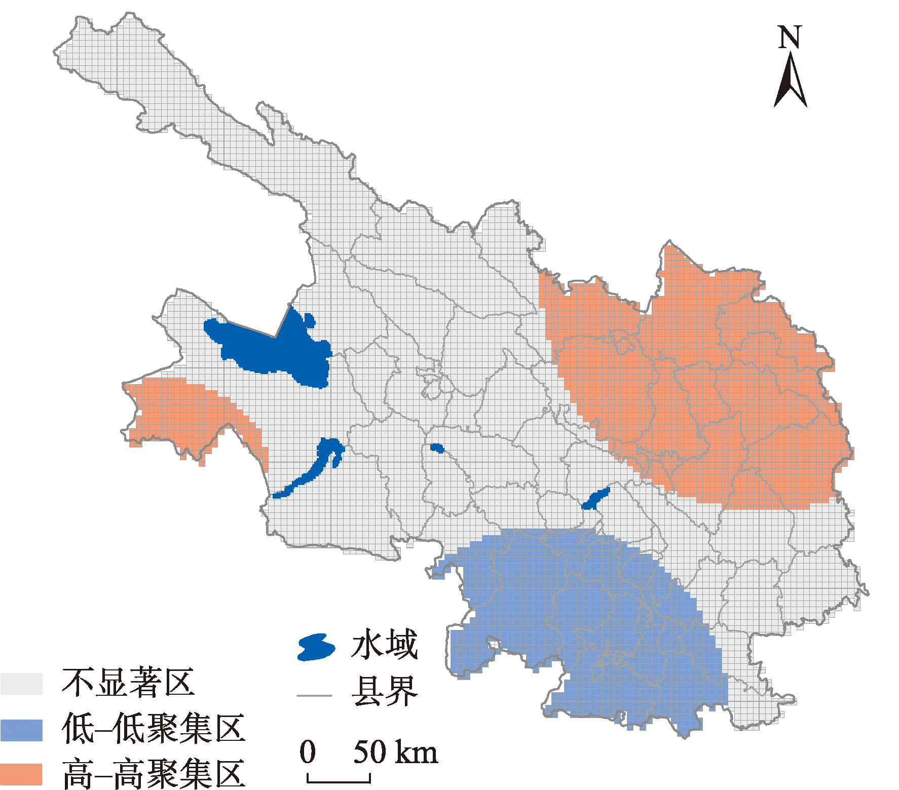
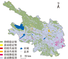
图6
2000—2020年河湟地区生态脆弱性整体转换格局"

表5
生态脆弱性16个探测指标的地理探测结果"
| 2000年 | 2005年 | 2010年 | 2015年 | 2020年 | ||||||||||
|---|---|---|---|---|---|---|---|---|---|---|---|---|---|---|
| q | P | q | P | q | P | q | P | q | P | |||||
| 干旱指数 | 0.409 | 0 | 0.363 | 0 | 0.352 | 0 | 0.379 | 0 | 0.380 | 0 | ||||
| 水土流失指数 | 0.273 | 0 | 0.253 | 0 | 0.243 | 0 | 0.267 | 0 | 0.251 | 0 | ||||
| 沙漠化指数 | 0.614 | 0 | 0.581 | 0 | 0.565 | 0 | 0.570 | 0 | 0.551 | 0 | ||||
| 人口密度 | 0.144 | 0 | 0.141 | 0 | 0.151 | 0 | 0.155 | 0 | 0.167 | 0 | ||||
| 夜间灯光强度 | 0.132 | 0 | 0.142 | 0 | 0.122 | 0 | 0.131 | 0 | 0.156 | 0 | ||||
| 用地强度 | 0.198 | 0 | 0.196 | 0 | 0.196 | 0 | 0.198 | 0 | 0.229 | 0 | ||||
| 土壤有机质含量 | 0.336 | 0 | 0.327 | 0 | 0.293 | 0 | 0.275 | 0 | 0.305 | 0 | ||||
| 景观多样性 | 0.116 | 0 | 0.121 | 0 | 0.137 | 0 | 0.120 | 0 | 0.131 | 0 | ||||
| 景观破碎度 | 0.109 | 0 | 0.102 | 0 | 0.104 | 0 | 0.101 | 0 | 0.102 | 0 | ||||
| 海拔 | 0.365 | 0 | 0.343 | 0 | 0.327 | 0 | 0.308 | 0 | 0.318 | 0 | ||||
| 坡度 | 0.060 | 0 | 0.062 | 0 | 0.049 | 0 | 0.038 | 0 | 0.051 | 0 | ||||
| 年均气温 | 0.309 | 0 | 0.301 | 0 | 0.273 | 0 | 0.234 | 0 | 0.285 | 0 | ||||
| 年降水量 | 0.208 | 0 | 0.211 | 0 | 0.301 | 0 | 0.330 | 0 | 0.283 | 0 | ||||
| 植被净初级生产力 | 0.591 | 0 | 0.561 | 0 | 0.586 | 0 | 0.593 | 0 | 0.605 | 0 | ||||
| 植被覆盖度 | 0.759 | 0 | 0.703 | 0 | 0.691 | 0 | 0.715 | 0 | 0.661 | 0 | ||||
| 生境质量指数 | 0.392 | 0 | 0.353 | 0 | 0.382 | 0 | 0.363 | 0 | 0.342 | 0 | ||||
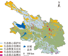
图7
河湟地区生态分区"

表6
生态脆弱性分区"
| 生态脆弱性分区 | 面积/km2 | 转换编码 | 分区依据 | 解释说明 |
|---|---|---|---|---|
| 生态核心保护区 | 33111 | 111,222 | 生态脆弱性分级常年为微度脆弱或轻度脆弱区域 | 对于5种生态分区划定依据是基于时间的先后顺序,即由2000年转向2020年因生态恢复关注区、生态优先治理区以及生态重点监测区的转换编码过多,故在表格中未进行一一列举 |
| 生态综合治理区 | 24501 | 333,444,555 | 生态脆弱性分级常年为中度脆弱、重度脆弱或极度脆弱区域 | |
| 生态恢复关注区 | 85009 | 211,221,231,241,251,311,312,321,322,331,332等 | 生态脆弱性由高脆弱性分级转向低脆弱性分级,生态脆弱性降低区域 | |
| 生态优先治理区 | 10558 | 112,113,114,122,123,132,133,142,144,213,214等 | 生态脆弱性由低脆弱性分级转向高脆弱性分级,生态脆弱性升高区域 | |
| 生态重点监测区 | 6110 | 121,131,141,212,232,242,252,313,323,343,353等 | 生态脆弱性分级在动态变化,但总体分级未发生改变区域 |
| [1] | 张震, 徐佳慧, 高琦, 等. 黄河流域经济高质量发展水平差异分析[J]. 科学管理研究, 2022, 40(1): 100-109. |
| [Zhang Zhen, Xu Jiahui, Gao Qi, et al. Analysis on the difference of economic high-quality development level in the Yellow River Basin[J]. Scientific Management Research, 2022, 40(1): 100-109.] | |
| [2] | 王慧. 黄河内蒙古段十大孔兑生态脆弱性演变及驱动力分析[D]. 呼和浩特: 内蒙古农业大学, 2020. |
| [Wang Hui. Eco-environment Vulnerability Evolution of the Seasonal River in Inner Mongolain Reach of the Yellow River and its Driving Force Analysis[D]. Hohhot: Inner Mongolia Agricultural University, 2020.] | |
| [3] | 田义超, 梁铭忠, 任志远. 城乡过渡区土地利用变化模拟与生态风险时空异质性特征[J]. 环境科学研究, 2013, 26(5): 540-548. |
| [Tian Yichao, Liang Mingzhong, Ren Zhiyuan. Simulation of land use change and temporal-spatial heterogeneity of eco-risk in urban fringe[J]. Research of Environmental Sciences, 2013, 26(5): 540-548.] | |
| [4] |
黄万状, 石培基. 河湟地区乡村聚落位序累积规模模型的实证研究[J]. 地理学报, 2021, 76(6): 1489-1503.
doi: 10.11821/dlxb202106012 |
|
[Huang Wanzhuang, Shi Peiji. An empirical study on rank cumulative size model of rural settlements in the Hehuang area[J]. Acta Geographica Sinica, 2021, 76(6): 1489-1503.]
doi: 10.11821/dlxb202106012 |
|
| [5] | 于悦. 地域环境适应下青海河湟地区庄廓聚落空间形态研究[D]. 青岛: 青岛理工大学, 2019. |
| [Yu Yue. Study on the Spatial Form of Zhuangkuo Settlements in Hehuang Area of Qinghai Province under the Adaptation of Regional Environment[D]. Qingdao: Qingdao University of Technology, 2019.] | |
| [6] |
钟晓娟, 孙保平, 赵岩, 等. 基于主成分分析的云南省生态脆弱性评价[J]. 生态环境学报, 2011, 20(1): 109-113.
doi: 10.16258/j.cnki.1674-5906(2011)01-0109-05 |
|
[Zhong Xiaojuan, Sun Baoping, Zhao Yan, et al. Ecological vulnerability evaluation based on principal component analysis in Yunnan province[J]. Ecology and Environmental Sciences, 2011, 20(1): 109-113.]
doi: 10.16258/j.cnki.1674-5906(2011)01-0109-05 |
|
| [7] |
Zhang X Y, Liu K, Wang S D. Spatiotemporal evolution of ecological vulnerability in the Yellow River Basin under ecological restoration initiatives[J]. Ecological Indicators, 2022, 135: 108586.
doi: 10.1016/j.ecolind.2022.108586 |
| [8] |
Yang X, Liu S, Jia C, et al. Vulnerability assessment and management planning for the ecological environment in urban wetlands[J]. Journal of Environmental Management, 2021, 298: 113540.
doi: 10.1016/j.jenvman.2021.113540 |
| [9] | 陈枫, 李泽红, 董锁成, 等. 基于VSD模型的黄土高原丘陵沟壑区县域生态脆弱性评价——以甘肃省临洮县为例[J]. 干旱区资源与环境, 2018, 32(11): 74-80. |
| [Chen Feng, Li Zehong, Dong Suocheng, et al. Evaluation of ecological vulnerability in gully-hilly region of Loess Plateau based on VSD model: A case of Lintao county[J]. Journal of Arid Land Resources and Environment, 2018, 32(11): 74-80.] | |
| [10] | 王鹏, 赵微, 柯新利. 基于SRP模型的潜江市生态脆弱性评价及时空演变[J]. 水土保持研究, 2021, 28(5): 347-354. |
| [Wang Peng, Zhao Wei, Ke Xinli. Evaluation and spatiotemporal evolution of ecological vulnerability of Qianjiang based on SRP model[J]. Research of Soil and Water Conservation, 2021, 28(5): 347-354.] | |
| [11] | 薛联青, 王晶, 魏光辉. 基于PSR模型的塔里木河流域生态脆弱性评价[J]. 河海大学学报(自然科学版), 2019, 47(1): 13-19. |
| [Xue Lianqing, Wang Jing, Wei Guanghui. Dynamic evaluation of the ecological vulnerability based on PSR modeling for the Tarim River Basin in Xinjiang[J]. Journal of Hohai University(Natural Sciences), 2019, 47(1): 13-19.] | |
| [12] |
Guo B, Luo W, Zang W. Spatial-temporal shifts of ecological vulnerability of Karst Mountain ecosystem-impacts of global change and anthropogenic interference[J]. Science of The Total Environment, 2020, 741: 140256.
doi: 10.1016/j.scitotenv.2020.140256 |
| [13] |
Boori M S, Choudhary K, Paringer R, et al. Using RS/GIS for spatiotemporal ecological vulnerability analysis based on DPSIR framework in the Republic of Tatarstan, Russia[J]. Ecological Informatics, 2022, 67: 101490.
doi: 10.1016/j.ecoinf.2021.101490 |
| [14] | 孙桂丽, 陆海燕, 郑佳翔, 等. 新疆生态脆弱性时空演变及驱动力分析[J]. 干旱区研究, 2022, 39(1): 258-269. |
| [Sun Guili, Lu Haiyan, Zheng Jiaxiang, et al. Spatio-temporal variation of ecological vulnerability in Xinjiang and driving force analysis[J]. Arid Zone Research, 2022, 39(1): 258-269.] | |
| [15] |
Gong J, Jin T T, Cao E J, et al. Is ecological vulnerability assessment based on the VSD model and AHP-Entropy method useful for loessial forest landscape protection and adaptative management? A case study of Ziwuling Mountain Region, China[J]. Ecological Indicators, 2022, 143: 109379.
doi: 10.1016/j.ecolind.2022.109379 |
| [16] |
Polsky C, Neff R, Yarnal B. Building comparable global change vulnerability assessments: The vulnerability scoping diagram[J]. Global Environmental Change, 2007, 17(34): 472-485.
doi: 10.1016/j.gloenvcha.2007.01.005 |
| [17] | 李珍珍. 甘肃省生态脆弱性时空演变及与土地利用关系研究[D]. 兰州: 兰州大学, 2019. |
| [Li Zhenzhen. Esearch on the Spatiotemporal Variation of Ecological Vulnerability and the Relationshipof Land Use in Gansu Province[D]. Lanzhou: Lanzhou University, 2019.] | |
| [18] |
Xia M, Jia K, Zhao W W, et al. Spatio-temporal changes of ecological vulnerability across the Qinghai-Tibetan Plateau[J]. Ecological Indicators, 2021, 123: 107274.
doi: 10.1016/j.ecolind.2020.107274 |
| [19] | 王顺久, 杨志峰, 丁晶. 关中平原地下水资源承载力综合评价的投影寻踪方法[J]. 资源科学, 2004, 26(6): 104-110. |
| [Wang Shunjiu, Yang Zhifeng, Ding Jing. Projection pursuit method of comprehensive evaluation on groundwater resources carrying capacity in Guanzhong plain[J]. Resources Science, 2004, 26(6): 104-110.] | |
| [20] | 霍童, 张序, 周云, 等. 基于暴露-敏感-适应性模型的生态脆弱性时空变化评价及相关分析——以中国大运河苏州段为例[J]. 生态学报, 2022, 42(6): 2281-2293. |
| [Huo Tong, Zhang Xu, Zhou Yun, et al. Evaluation and correlation analysis of spatio-temporal changes of ecological vulnerability based on VSD model: A case in Suzhou section, Grand Canal of China[J]. Acta Ecologica Sinica, 2022, 42(6): 2281-2293.] | |
| [21] | 戢晓峰, 谢军, 伍景琼. 考虑不同侵扰场景的高速公路韧性评估方法[J]. 中国安全生产科学技术, 2019, 15(1): 12-19. |
| [Ji Xiaofeng, Xie Jun, Wu Jingqiong. Assessment method of expressway resilience considering different intrusion scenes[J]. Journal of Safety Science and Technology, 2019, 15(1): 12-19.] | |
| [22] | 马骏, 李昌晓, 魏虹, 等. 三峡库区生态脆弱性评价[J]. 生态学报, 2015, 35(21): 7117-7129. |
| [Ma Jun, Li Changxiao, Wei Hong, et al. Dynamic evaluation of ecological vulnerability in the Three Gorges Reservoir Region in Chongqing Municipality, China[J]. Acta Ecologica Sinica, 2015, 35(21): 7117-7129.] | |
| [23] | 孙宇晴, 杨鑫, 郝利娜. 基于 SRP 模型的川藏线 2010—2020 年生态脆弱性时空分异与驱动机制研究[J]. 水土保持通报, 2022, 41(6): 201-208. |
| [Sun Yuqing, Yang Xin, Hao Lina. Spatial and temporal differentiation and driving mechanism of ecological vulnerability along Sichuan-Tibet Railway during 2010-2020 based on SRP model[J]. Bulletin of Soil and Water Conservation, 2022, 41(6): 201-208.] | |
| [24] | 王志杰, 苏嫄. 南水北调中线汉中市水源地生态脆弱性评价与特征分析[J]. 生态学报, 2018, 38(2): 432-442. |
| [Wang Zhijie, Su Yuan. Analysis of eco-environmental vulnerability characteristics of Hanzhong City, near the water source midway along the route of the south-to-north water transfer project, China[J]. Acta Ecologica Sinica, 2018, 38(2): 432-442.] | |
| [25] | 郭靖娴, 刘婷, 齐小娟, 等. 时空扫描法在浙江省食源性疾病时空聚集性分析中的应用[J]. 中国预防医学杂志, 2020, 21(11): 1171-1177. |
| [Guo Jingxian, Liu Ting, Qi Xiaojuan, et al. Application of spatio-temporal scanning in the analysis of spatio-temporal clusters of foodborne diseases in Zhejiang province[J]. Chinese Preventive Medicine, 2020, 21(11): 1171-1177.] | |
| [26] | 张学渊, 魏伟, 周亮, 等. 西北干旱区生态脆弱性时空演变分析[J]. 生态学报, 2021, 41(12): 4707-4719. |
| [Zhang Xueyuan, Wei Wei, Zhou Liang, et al. Analysis on spatio-temporal evolution of ecological vulnerability in arid areas of Northwest China[J]. Acta Ecologica Sinica, 2021, 41(12): 4707-4719.] | |
| [27] | 张欣, 潘竟虎. 中国城市蔓延时空动态识别及驱动因素探测[J]. 人文地理, 2021, 36(4): 114-125. |
| [Zhang Xin, Pan Jinghu. Identification of spatio-temporal dynamics and detection for driving factors of urban sprawl in China[J]. Human Geography, 2021, 36(4): 114-125.] | |
| [28] |
张良侠, 樊江文, 张海燕, 等. 黄土高原地区生态脆弱性时空变化及其驱动因子分析[J]. 环境科学, 2022, 43(9): 4902-4910.
doi: 10.1021/es900179s |
|
[Zhang Liangxia, Fan Jiangwen, Zhang Haiyan, et al. Spatial-temporal variations and their driving forces of the ecological vulnerability in the Loess Plateau[J]. Environmental Science, 2022, 43(9): 4902-4910.]
doi: 10.1021/es900179s |
|
| [29] | 石三娥. 西北五省生态环境脆弱性时空演变研究[D]. 兰州: 西北师范大学, 2019. |
| [Shi San’e. Study on the Spatial and Temporal Evolution of Ecological Environment Vulnerability in Five Provinces in Northwest China[D]. Lanzhou: Northwest Normal University, 2019.] | |
| [30] | 吴恒飞, 陈克龙, 张乐乐. 气候变化下青海湖流域生态健康评价研究[J]. 生态科学, 2022, 41(4): 41-48. |
| [Wu Hengfei, Chen Kelong, Zhang Lele. Study on ecological health evaluation of Qinghai Lake Basin under climate change[J]. Ecological Science, 2022, 41(4): 41-48.] |
| [1] | 刘军彦,王世杰. 基于ICESat-2卫星测高数据的呼伦湖水位变化监测[J]. 干旱区研究, 2023, 40(9): 1438-1445. |
| [2] | 海龙, 周梅, 张嘉開, 洪光宇, 李凤滋, 费菲. 毛乌素沙地不同林龄杨柴灌木林土壤呼吸及其影响因素[J]. 干旱区研究, 2023, 40(7): 1107-1116. |
| [3] | 刘笑, 郭鹏, 祁佳峰, 杜文玲, 张茹倩, 张坤. 基于MRSEI模型的阿勒泰市生态环境时空变化及驱动力分析[J]. 干旱区研究, 2023, 40(6): 1014-1026. |
| [4] | 吕锦心, 梁康, 刘昌明, 张仪辉, 刘璐. 无定河流域土地覆被空间分异机制及相关水碳变量变化[J]. 干旱区研究, 2023, 40(4): 563-572. |
| [5] | 李鑫磊, 李瑞平, 王秀青, 王思楠, 王成坤. 基于地理探测器的河套灌区林草植被覆盖度时空变化与驱动力分析[J]. 干旱区研究, 2023, 40(4): 623-635. |
| [6] | 马晓蕾,乔雅琦,王婕,焦士兴,张曼. 陕西省水生态足迹深度与广度时空格局及影响因素[J]. 干旱区研究, 2023, 40(3): 469-480. |
| [7] | 马浩文, 王永芳, 郭恩亮. 基于GEE的翁牛特旗土地沙漠化遥感监测[J]. 干旱区研究, 2023, 40(3): 504-516. |
| [8] | 徐涛,于欢,孔博,邱霞,胡孟珂,凌鹏飞. 藏北高原砾石粒径空间异质性研究[J]. 干旱区研究, 2023, 40(2): 292-302. |
| [9] | 董翰林, 王文婷, 谢云, 阿依达娜·叶斯那力, 江源天, 徐嘉淇. 新疆气候干湿变化特征及其影响因素[J]. 干旱区研究, 2023, 40(12): 1875-1884. |
| [10] | 贺军奇,拜寒伟,徐轶玮,倪莉莉. 陕西黄土区农田土壤主要养分特征及影响因素[J]. 干旱区研究, 2023, 40(12): 1907-1917. |
| [11] | 吴万民, 刘涛, 陈鑫. 西北干旱半干旱区NDVI季节性变化及其影响因素[J]. 干旱区研究, 2023, 40(12): 1969-1981. |
| [12] | 侯文兵, 李开明, 黄卓. 近20 a河西地区绿洲效应时空变化特征及归因分析[J]. 干旱区研究, 2023, 40(12): 2031-2042. |
| [13] | 程红霞, 林粤江, 陈鹏, 梁凤超, 王勇. 塔里木盆地沙尘天气日数变化及影响因素[J]. 干旱区研究, 2023, 40(11): 1707-1717. |
| [14] | 吴雪晴, 张乐乐, 高黎明, 李炎坤, 刘轩辰. 青海湖流域NPP动态变化及驱动力[J]. 干旱区研究, 2023, 40(11): 1824-1832. |
| [15] | 裴宏泽, 赵亚超, 张廷龙. 2000—2020年黄土高原NEP时空格局与驱动力[J]. 干旱区研究, 2023, 40(11): 1833-1844. |
|
||