干旱区研究 ›› 2023, Vol. 40 ›› Issue (4): 636-646.doi: 10.13866/j.azr.2023.04.12 cstr: 32277.14.AZR.20230412
赵剑1,2,3( ),邓成军4,李文利4,赵金1,公延明1,2,李凯辉1,2()
收稿日期:2022-06-06
修回日期:2023-01-28
出版日期:2023-04-15
发布日期:2023-04-28
作者简介:赵剑(1997-),男,硕士研究生,主要从事草原生态遥感监测. E-mail: 基金资助:
ZHAO Jian1,2,3(),DENG Chengjun4,LI Wenli4,ZHAO Jin1,GONG Yanming1,2,LI Kaihui1,2()
Received:2022-06-06
Revised:2023-01-28
Published:2023-04-15
Online:2023-04-28
摘要:
植被覆盖度和生产力指标作为评价草原生态系统退化已有较多研究,各单一评价指标互相独立难以对不同草原退化程度进行综合评价。本研究以新疆天山中部巴音布鲁克草原为研究对象,提出了一种基于标准化处理分指标耦合的草原退化遥感评估方法。选取草原植被覆盖度、草层平均高度、总产草量3个分指标,通过主成分分析法确定分指标权重,并引入Min-Max标准化方法处理并构建综合评价指标草地退化指数(Grassland Degradation Index,GDI),最终通过Landsat影像反演以及草地退化指数变化率的合理分级评估了1986—2021年新疆天山巴音布鲁克草原的退化程度。结果表明:(1) GDIg与NDVI的相关性最好。(2) 2021年巴音布鲁克草原未退化面积占总面积的比例为60.51 %;不同草地类型的草地退化程度有明显差异;空间分布上表现为由盆地向山地退化加重的趋势。(3) 通过辐射配准方法可以将GDIrs模型应用于其他年份,2000—2009年巴音布鲁克草原退化程度明显改善,2009—2021年草原退化程度轻微波动。研究结果将为指导巴音布鲁克草原退化程度的评价和保护草原生态系统提供一定的数据支撑和理论基础。
赵剑, 邓成军, 李文利, 赵金, 公延明, 李凯辉. 近35 a新疆天山巴音布鲁克草原退化程度评价[J]. 干旱区研究, 2023, 40(4): 636-646.
ZHAO Jian, DENG Chengjun, LI Wenli, ZHAO Jin, GONG Yanming, LI Kaihui. Evaluation of the degree of degradation of Xinjiang Tianshan Bayinbuluk grassland in 35 years[J]. Arid Zone Research, 2023, 40(4): 636-646.
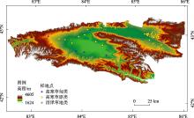
图1
研究区位置及样地点位 注:底图采用自然资源部标准地图制作,审图号为GS(2019)3333号,对底图边界无修改。"

表1
植被指数及计算公式"
| 植被指数 | 计算公式 | 参考文献 |
|---|---|---|
| 归一化植被指数 | [ | |
| 差值植被指数 | [ | |
| 比值植被指数 | [ | |
| 增强型植被指数 | [ | |
| 土壤植被指数 | [ | |
| 三波段梯度差植被指数 | [ |
表2
主要植物种类"
| 草地类 | 植物种类 |
|---|---|
| 高寒草甸类 | 白尖薹草(Carex oxyleuca) |
| 鬼箭锦鸡儿(Caragana jubata) | |
| 线叶嵩草(Kobresia capillifolia) | |
| 细果薹草(Carex stenocarpa) | |
| 珠芽蓼(Polygonum viviparum) | |
| 高寒草原类 | 新疆薹草(Carex turkestanica) |
| 溚草(Koeleria macrantha) | |
| 寒生羊茅(Festuca kryloviana) | |
| 宽穗赖草(Leymus ovatus) | |
| 冰草(Agropyron cristatum) | |
| 天山鸢尾(Iris loczyi Kanitz) | |
| 紫花针茅(Stipa purpurea) | |
| 椒蒿(Artemisia dracunculus) | |
| 野黑麦(Secale sylvestre) | |
| 冷蒿(Artemisia frigida) | |
| 座花针茅(Stipa subsessiliflora) | |
| 沼泽草地类 | 柄囊薹草(Carex stenophylla) |
| 布顿大麦草(Hordeum bogdanii) | |
| 扁灯芯草(Juncus compressus) |
表3
20世纪80年代草原普查数据集"
| 草地类 | 草地型 | 平均盖度/% | 总产草量/(kg·hm-2) | 平均高度/cm | |
|---|---|---|---|---|---|
| 高寒草甸类 | 白尖薹草、杂类草 | 85 | 3108.00 | 14.0 | 0.52 |
| 鬼箭锦鸡儿、线叶嵩草、杂类草 | 90 | 3199.50 | 25.0 | 0.78 | |
| 线叶嵩草 | 90 | 3237.00 | 20.0 | 0.68 | |
| 线叶嵩草、白尖薹草、杂类草 | 90 | 3031.50 | 20.0 | 0.68 | |
| 线叶嵩草、细果薹草、珠芽蓼 | 90 | 6631.50 | 17.5 | 0.75 | |
| 线叶嵩草、杂类草 | 90 | 7485.00 | 25.0 | 0.93 | |
| 珠芽蓼、细果薹草、杂类草 | 90 | 3247.50 | 12.5 | 0.53 | |
| 高寒草原类 | 新疆薹草、溚草 | 60 | 1546.50 | 16.5 | 0.34 |
| 新疆薹草、寒生羊茅 | 65 | 2173.50 | 15.0 | 0.37 | |
| 新疆薹草、宽穗赖草 | 40 | 5620.50 | 12.5 | 0.26 | |
| 新疆薹草、杂类草 | 60 | 4480.50 | 20.0 | 0.51 | |
| 寒生羊茅、冰草 | 50 | 1705.50 | 10.0 | 0.15 | |
| 寒生羊茅、新疆薹草、天山鸢尾 | 85 | 1770.00 | 15.0 | 0.50 | |
| 寒生羊茅、紫花针茅 | 50 | 1827.00 | 12.5 | 0.20 | |
| 宽穗赖草 | 35 | 1380.60 | 20.0 | 0.23 | |
| 宽穗赖草、椒蒿 | 35 | 1380.60 | 20.0 | 0.23 | |
| 天山鸢尾、新疆薹草、紫花针茅 | 85 | 1914.00 | 17.5 | 0.55 | |
| 天山鸢尾、寒生羊茅 | 85 | 1914.00 | 17.5 | 0.55 | |
| 野黑麦、杂类草 | 85 | 5319.00 | 22.5 | 0.77 | |
| 紫花针茅、冰草、杂类草 | 50 | 498.00 | 12.5 | 0.16 | |
| 紫花针茅、新疆薹草 | 50 | 951.00 | 17.5 | 0.27 | |
| 紫花针茅、新疆薹草、寒生羊茅 | 50 | 1827.00 | 12.5 | 0.20 | |
| 紫花针茅、寒生羊茅、冰草 | 50 | 1827.00 | 12.5 | 0.20 | |
| 紫花针茅、宽穗赖草 | 50 | 951.00 | 17.5 | 0.27 | |
| 紫花针茅、冷蒿 | 45 | 913.50 | 17.5 | 0.24 | |
| 紫花针茅、杂类草 | 50 | 951.00 | 17.5 | 0.27 | |
| 座花针茅、宽穗赖草 | 50 | 1380.60 | 20.0 | 0.34 | |
| 沼泽草地类 | 柄囊薹草 | 100 | 4128.00 | 17.5 | 0.73 |
| 布顿大麦草、扁灯芯草 | 100 | 4323.00 | 12.5 | 0.64 |
表4
2021年建模样地数据集"
| 样地号 | 平均盖度/% | 总产草量/(kg·hm-2) | 平均高度/cm | |
|---|---|---|---|---|
| 001 | 75 | 3560.00 | 15.0 | 0.56 |
| 002 | 95 | 4336.00 | 15.0 | 0.70 |
| 003 | 100 | 6387.00 | 20.0 | 0.85 |
| 004 | 94 | 2013.00 | 6.0 | 0.52 |
| 005 | 100 | 10233.00 | 18.0 | 0.84 |
| 006 | 80 | 2263.33 | 7.0 | 0.46 |
| 007 | 84 | 2506.00 | 31.0 | 0.72 |
| 008 | 82 | 2586.00 | 12.0 | 0.53 |
| 009 | 60 | 1933.00 | 12.0 | 0.38 |
| 010 | 100 | 1870.00 | 12.0 | 0.61 |
| 011 | 70 | 1703.00 | 12.0 | 0.43 |
| 012 | 70 | 2503.00 | 22.0 | 0.56 |
| 013 | 50 | 2556.00 | 23.0 | 0.45 |
| 014 | 88 | 3566.00 | 27.0 | 0.74 |
| 015 | 80 | 1817.00 | 16.0 | 0.53 |
| 016 | 75 | 2460.00 | 15.0 | 0.52 |
| 017 | 65 | 1403.33 | 5.7 | 0.33 |
| 018 | 55 | 1160.00 | 5.3 | 0.26 |
| 019 | 65 | 776.67 | 4.0 | 0.29 |
| 020 | 75 | 2070.00 | 8.7 | 0.44 |
| 021 | 55 | 1210.00 | 5.0 | 0.26 |
| 022 | 55 | 520.00 | 3.7 | 0.22 |
| 023 | 90 | 2393.33 | 7.7 | 0.53 |
| 024 | 40 | 703.33 | 4.0 | 0.15 |
| 025 | 85 | 1576.67 | 8.3 | 0.48 |
| 026 | 40 | 710.00 | 4.3 | 0.15 |
| 027 | 41 | 1980.00 | 6.4 | 0.22 |
| 028 | 40 | 979.50 | 7.6 | 0.19 |
| 029 | 34 | 960.00 | 9.6 | 0.18 |
| 030 | 44 | 864.00 | 4.7 | 0.18 |
| 031 | 92 | 6853.00 | 34.0 | 0.95 |
| 032 | 95 | 2660.00 | 19.0 | 0.67 |
| 033 | 95 | 3240.00 | 9.7 | 0.61 |
| 034 | 84 | 2482.50 | 13.0 | 0.55 |
| 035 | 83 | 3720.00 | 11.5 | 0.57 |
表5
指标权重系数"
| 植被覆盖度 | 草层平均高度 | 总产草量 | |
|---|---|---|---|
| 20世纪80年代模型系数 | 0.59 | 0.36 | 0.30 |
| 2021年模型系数 | 0.59 | 0.44 | 0.32 |
| 20世纪80年代指标权重 | 0.47 | 0.29 | 0.24 |
| 2021年指标权重 | 0.44 | 0.32 | 0.24 |
| 权重平均值 | 0.46 | 0.30 | 0.24 |

图2
不同海拔梯度退化面积"

表6
2000年、2009年和2021年草原退化情况"
| 退化程度 | 1986—2000年 面积/hm2 | 1986—2000年 比例/% | 1986—2009年 面积/hm2 | 1986—2009年比例/% | 1986—2021年 面积/hm2 | 1986—2021年 比例/% |
|---|---|---|---|---|---|---|
| 重度退化 | 247967.37 | 16.47 | 163884.51 | 10.89 | 221458.95 | 14.71 |
| 中度退化 | 431370.63 | 28.66 | 193017.06 | 12.82 | 188894.07 | 12.55 |
| 轻度退化 | 243514.08 | 16.18 | 177344.28 | 11.78 | 184102.11 | 12.23 |
| 未退化 | 582457.77 | 38.69 | 971064.00 | 64.51 | 910854.72 | 60.51 |
| [1] | 张新时, 唐海萍, 董孝斌, 等. 中国草原的困境及其转型[J]. 科学通报, 2016, 61(2): 165-177. |
| [Zhang Xinshi, Tang Haiping, Dong Xiaobin, et al. The dilemma of steppe and it’s transformation in China[J]. Chinese Science Bulletin, 2016, 61(2): 165-177.] | |
| [2] | 沈海花, 朱言坤, 赵霞, 等. 中国草地资源的现状分析[J]. 科学通报, 2016, 61(2): 139-154. |
| [Shen Haihua, Zhu Yankun, Zhao Xia, et al. Analysis of current grassland resources in China[J]. Chinese Science Bulletin, 2016, 61(2): 139-154.] | |
| [3] | 杨红飞, 刚成诚, 穆少杰, 等. 近10年新疆草地生态系统净初级生产力及其时空格局变化研究[J]. 草业学报, 2014, 23(3): 39-50. |
| [Yang Hongfei, Gang Chengcheng, Mu Shaojie, et al. Analysis of the spatio-temporal variation in net primary productivity of grassland during the past 10 years in Xinjiang[J]. Acta Prataculturae Sinica, 2014, 23(3): 39-50.] | |
| [4] | 迪利夏提·哈斯木. 新疆草地资源现状与生态保护[J]. 新疆环境保护, 2013, 35(S1): 41-44. |
| [Dilixiati Hasimu. Current situation and ecological protection of grassland resources in Xinjiang[J]. Environmental Protection of Xinjiang, 2013, 35(S1): 41-44.] | |
| [5] | 李文利, 何文革. 新疆巴音布鲁克草原退化及其驱动力分析[J]. 青海草业, 2008, 17(2): 44-47. |
| [Li Wenli, He Wenge. The analysis on driven forces of degradation of Bayinbulake grassland in Xinjiang[J]. Qinghai Prataculture, 2008, 17(2): 44-47.] | |
| [6] |
张海燕, 樊江文, 邵全琴. 2000—2010年中国退牧还草工程区土地利用/覆被变化[J]. 地理科学进展, 2015, 34(7): 840-853.
doi: 10.18306/dlkxjz.2015.07.006 |
|
[Zhang Haiyan, Fan Jiangwen, Shao Quanqin. Land use/land cover change in the grassland restoration program areas in China, 2000-2010[J]. Progress in Geography, 2015, 34(7): 840-853.]
doi: 10.18306/dlkxjz.2015.07.006 |
|
| [7] | 仇焕广, 张崇尚, 刘乐, 等. 我国草原管理制度演变及社区治理机制创新[J]. 经济社会体制比较, 2020(3): 48-56. |
| [Qiu Huanguang, Zhang Chongshang, Liu Le, et al. Evolution of grassland management institutions and innovation of the local governance mechanism in China[J]. Comparative Economic & Social Systems, 2020(3): 48-56.] | |
| [8] |
Zhou Wei, Yang Han, Huang Lu, et al. Grassland degradation remote sensing monitoring and driving factors quantitative assessment in China from 1982 to 2010[J]. Ecological Indicators, 2017, 83: 303-313.
doi: 10.1016/j.ecolind.2017.08.019 |
| [9] |
吴晓全, 王让会, 李成, 等. 天山植被NPP时空特征及其对气候要素的响应[J]. 生态环境学报, 2016, 25(11): 1848-1855.
doi: 10.16258/j.cnki.1674-5906.2016.11.017 |
|
[Wu Xiaoquan, Wang ranghui, Li Cheng, et al. Spatial-temporal characteristics of NPP and its response to climatic factors in Tianshan Mountains region[J]. Ecology and Environmental Sciences, 2016, 25(11): 1848-1855.]
doi: 10.16258/j.cnki.1674-5906.2016.11.017 |
|
| [10] | 杜自强, 王建, 李建龙, 等. 黑河中上游典型地区草地植被退化遥感动态监测[J]. 农业工程学报, 2010, 26(4): 180-185. |
| [Du Ziqiang, Wang Jian, Li Jianlong, et al. Remote sensing-based monitor dynamically grassland degradation in typical regions, middle and upper reaches of Heihe River Basin, western China[J]. Transactions of the Chinese Society of Agricultural Engineering, 2010, 26(4): 180-185.] | |
| [11] | 赵玉婷, 李文龙, 陈迪, 等. 高寒牧区草地生态系统健康动态评价——以甘南地区为例[J]. 草业科学, 2017, 34(1): 16-29. |
| [Zhao Yuting, Li Wenlong, Chen Di, et al. Dynamic assessment of alpine pasture grassland ecosystem health: A case study from the Gannan region[J]. Pratacultural Science, 2017, 34(1): 16-29.] | |
| [12] | 陆均, 胡玉昆, 岳平, 等. 基于CVOR指数的巴音布鲁克高寒草原健康评价[J]. 干旱区研究, 2017, 34(4): 862-869. |
| [Lu Jun, Hu Yukun, Yue Ping, et al. Assessment on the health of alpine steppe in Bayinbuluk based on CVOR index[J]. Arid Zone Research, 2017, 34(4): 862-869.] | |
| [13] | 吴志丰, 李芬, 张林波, 等. 三江源区草地参照覆盖度提取及草地退化研究[J]. 自然灾害学报, 2014, 23(2): 94-102. |
| [Wu Zhifeng, Li Fen, Zhang Linbo, et al. Research on grassland degradation of Three-River headwaters region based on reference vegetation coverage[J]. Journal of Natural Disasters, 2014, 23(2): 94-102.] | |
| [14] | 李霞, 潘冬荣, 孙斌, 等. 甘肃省草地退化概况分析——基于甘肃省第一、二次草原普查数据[J]. 草业科学, 2022, 39(3): 485-494. |
| [Li Xia, Pan Dongrong, Sun Bin, et al. Analysis of grassland degradation in Gansu Province based on two grassland surveys[J]. Pratacultural Science, 2022, 39(3): 485-494.] | |
| [15] |
Yang Yanlin, Wang Jinliang, Chen Yun, et al. Remote-sensing monitoring of grassland degradation based on the GDI in Shangri-La, China[J]. Remote Sensing, 2019, 11(24): 3030.
doi: 10.3390/rs11243030 |
| [16] | 公延明, 胡玉昆, 阿德力·麦地, 等. 巴音布鲁克高寒草地退化演替阶段植物群落特性研究[J]. 干旱区资源与环境, 2010, 24(6): 149-152. |
| [Gong Yanming, Hu Yukun, Adeli Maidi, et al Alpine grassland community characteristics at the different stages of degenerating succession in Bayanbulak[J]. Journal of Arid Land Resources and Environment, 2010, 24(6): 149-152.] | |
| [17] |
Choi Jaewon, Oh Hyun-Joo, Won Joong-Sun, et al. Validation of an artificial neural network model for landslide susceptibility mapping[J]. Environmental Earth Sciences, 2010, 60(3): 473-483.
doi: 10.1007/s12665-009-0188-0 |
| [18] | 张雨斯, 包玉海, 贺忠华. 1990—2021年内蒙古遥感生态环境质量变化及趋势分析——以呼伦贝尔市陈巴尔虎旗为例[J]. 干旱区研究, 2023, 40(2): 326-336. |
| [Zhang Yusi, Bao Yuhai, He Zhonghua. Detecting the change and trend of remote sensing ecological quality in Inner Mongolia from 1990-2021: A case study of Chenbarhu Banner of Hulunbuir City[J]. Arid Zone Research, 2023, 40(2): 326-336.] | |
| [19] | 冯双双. 基于Landsat影像的草地退化动态监测[D]. 石家庄: 河北师范大学, 2016. |
| [Feng Shuangshuang. Dynamic Monitoring of Grassland Degradation Based on Landsat Image[D]. Shijiazhuang: Hebei Normal University, 2016.] | |
| [20] |
Lyu Xin, Li Xiaobing, Gong Jirui, et al. Comprehensive grassland degradation monitoring by remote sensing in Xilinhot, Inner Mongolia, China[J]. Sustainability, 2020, 12(9): 3682.
doi: 10.3390/su12093682 |
| [21] | 徐剑波, 宋立生, 赵之重, 等. 近15 a来黄河源地区玛多县草地植被退化的遥感动态监测[J]. 干旱区地理, 2012, 35(4): 615-622. |
| [Xu Jianbo, Song Lisheng, Zhao Zhizhong, et al. Monitoring grassland degradation dynamically at Maduo County in source region of Yellow River in past 15 years based on remote sensing[J]. Arid Land Geography, 2012, 35(4): 615-622.] | |
| [22] |
Li Lanhui, Zhang Yili, Liu Linshan, et al. Spatiotemporal patterns of vegetation greenness change and associated climatic and anthropogenic drivers on the Tibetan Plateau during 2000-2015[J]. Remote Sensing, 2018, 10(10): 1525.
doi: 10.3390/rs10101525 |
| [23] |
Tucker J Compton. Red and photographic infrared linear combinations for monitoring vegetation[J]. Remote Sensing of Environment, 1979, 8(2): 127-150.
doi: 10.1016/0034-4257(79)90013-0 |
| [24] | Richardson A J, Wiegand C L. Distinguishing vegetation from soil background information[J]. Photogrammetric Engineering and Remote Sensing, 1977, 43(12): 1541-1552. |
| [25] |
Jordan C F. Derivation of leaf area index from light quality of the forest floor[J]. Ecology, 1969, 50(4): 663-666.
doi: 10.2307/1936256 |
| [26] |
Liu Jiangui, Shang Jiali, Qian Budong, et al. Crop yield estimation using time-series MODIS data and the effects of cropland masks in Ontario, Canada[J]. Remote Sensing, 2019, 11(20): 2419.
doi: 10.3390/rs11202419 |
| [27] |
Huete A R. A soil-adjusted vegetation index (SAVI)[J]. Remote Sensing of Environment, 1988, 25(3): 295-309.
doi: 10.1016/0034-4257(88)90106-X |
| [28] | 唐世浩, 朱启疆, 王锦地, 等. 三波段梯度差植被指数的理论基础及其应用[J]. 中国科学(D辑:地球科学), 2003, 33(11): 1094-1102. |
| [Tang Shihao, Zhu Qijiang, Wang Jindi, et al. Theoretical basis and application of three band gradient difference vegetation index[J]. Chinese Science (Series D: Earth Science), 2003, 33(11): 1094-1102.] | |
| [29] | 中华人民共和国国家质量监督检验检疫总局. GB 19377-2003. 天然草地退化、沙化、盐渍化的分级指标[S]. 2003. |
| [General Administration of Quality Supervision. GB 19377-2003. Parameters for Degradation, Sandification and Salification of Rangeland[S]. 2003.] | |
| [30] | 曹旭娟, 干珠扎布, 梁艳, 等. 基于NDVI的藏北地区草地退化时空分布特征分析[J]. 草业学报, 2016, 25(3): 1-8. |
| [Cao Xujuan, Ganzhu Zhabu, Liang Yan, et al. Temporal and spatial distribution of grassland degradation in northern Tibet based on NDVI[J]. Acta Prataculturae Sinica, 2016, 25(3): 1-8.] | |
| [31] |
李莉, 李峰. 基于RS和GIS的四川草地退化分析[J]. 中国农学通报, 2017, 33(17): 87-91.
doi: 10.11924/j.issn.1000-6850.casb16090006 |
|
[Li Li, Li Feng. Grassland degradation analysis in Sichuan based on RS and GIS[J]. Chinese Agricultural Science Bulletin, 2017, 33(17): 87-91.]
doi: 10.11924/j.issn.1000-6850.casb16090006 |
|
| [32] | 朱宁, 王浩, 宁晓刚, 等. 草地退化遥感监测研究进展[J]. 测绘科学, 2021, 46(5): 66-76. |
| [Zhu Ning, Wang Hao, Ning Xiaogang, et al. Advances in remote sensing monitoring of grassland degradation[J]. Science of Surveying and Mapping, 2021, 46(5): 66-76.] | |
| [33] | 焦阿永, 陈伏龙, 闫俊杰, 等. 北疆地区草地TI-NDVI与NDVImax时空异质性评价[J]. 干旱区研究, 2022, 39(4): 1155-1165. |
| [Jiao Ayong, Chen Fulong, Yan Junjie, et al. Spatio-temporal heterogeneity evaluation of grassland TI-NDVI and NDVImax in northern Xinjiang[J]. Arid Zone Research, 2022, 39(4): 1155-1165.] | |
| [34] |
Gang C, Zhou W, Wang Z, et al. Comparative assessment of grassland NPP dynamics in response to climate change in China, North America, Europe and Australia from 1981 to 2010[J]. Journal of Agronomy and Crop Science, 2015, 201(1): 57-68.
doi: 10.1111/jac.12088 |
| [35] | 张文博. 基于MODIS数据的草地退化遥感监测方法研究[D]. 北京: 中国农业科学院, 2020. |
| [Zhang Wenbo. Research on Remote Sensing Monitoring Method of Grassland Degradation Using MODIS Data[D]. Beijing: Chinese Academy of Agricultural Sciences, 2020.] | |
| [36] |
Fu Aihong, Chen Yaying, Li Weihong, et al. Spatial and temporal patterns of climate variations in the Kaidu River Basin of Xinjiang, Northwest China[J]. Quaternary International, 2013, 311: 117-122.
doi: 10.1016/j.quaint.2013.08.041 |
| [37] | 刘濛濛, 隆永兰. 巴音布鲁克近58 a气候变化特征分析[J]. 干旱区地理, 2019, 42(4): 715-723. |
| [Liu Mengmeng, Long Yonglan. Climatic variation characteristics in Bayinbuluk during the past 58 years[J]. Arid Land Geography, 2019, 365 42(4): 715-723.] | |
| [38] |
赵鹏, 陈桃, 王茜, 等. 气候变化和人类活动对新疆草地生态系统NPP影响的定量分析[J]. 中国科学院大学学报, 2020, 37(1): 51-62.
doi: 10.7523/j.issn.2095-6134.2020.01.007 |
|
[Zhao Peng, Chen Tao, Wang Qian, et al. Quantitative analysis of the impact of climate change and human activities on grassland ecosystem NPP in Xinjiang[J]. Journal of university of Chinese Academy of Sciences, 2020, 37(1): 51-62.]
doi: 10.7523/j.issn.2095-6134.2020.01.007 |
|
| [39] | 姚俊强, 李漠岩, 迪丽努尔·托列吾别克, 等. 不同时间尺度下新疆气候“暖湿化”特征[J]. 干旱区研究, 2022, 39(2): 333-346. |
| [Yao Junqiang, Li Moyan, Dilinuer Tuoliewubieke, et al. The assessment on“warming-wetting”trend in Xinjiang at multi-scale during 1961-2019[J]. Arid Zone Research, 2022, 39(2): 333-346.] | |
| [40] | 曹永香, 毛东雷, 薛杰, 等. 绿洲-沙漠过渡带植被覆盖动态变化及其驱动因素——以新疆策勒为例[J]. 干旱区研究, 2022, 39(2): 510-521. |
| [Cao Yongxiang, Mao Donglei, Xue Jie, et al. Dynamic changes and driving factors of vegetation cover in the oasis-desert ecotone: A case study of Cele, Xinjiang[J]. Arid Zone Research, 2022, 39(2): 510-521.] | |
| [41] | 潘庆民, 薛建国, 陶金, 等. 中国北方草原退化现状与恢复技术[J]. 科学通报, 2018, 63(17): 1642-1650. |
| [Pan Qingmin, Xue Jianguo, Tao Jin, et al. Current status of grassland degradation and measures for grassland restoration in northern China[J]. Chinese Science Bulletin, 2018, 63(17): 1642-1650.] |
| [1] | 高晓瑜,汤鹏程,张莎,屈忠义,杨威. 内蒙古各气候区主要作物生长季干旱特征及其与响应因子回归模型[J]. 干旱区研究, 2022, 39(5): 1410-1427. |
| [2] | 陈心池,张利平,闪丽洁,杨卫,贾军. 新疆山区中小河流洪水预报模型及其应用[J]. 干旱区研究, 2017, 34(6): 1426-1435. |
| [3] | 曲武, 卢文喜, 王喜华, 陈继红. Monte-carlo与NNBR模型结合在年降水量预测中的应用[J]. 干旱区研究, 2012, 29(1): 55-58. |
|
||