干旱区研究 ›› 2024, Vol. 41 ›› Issue (1): 169-180.doi: 10.13866/j.azr.2024.01.16
• 生态与环境 • 上一篇
刘一丹1( ),姚晓军1(),李宗省1,2,胡家瑜1
收稿日期:2023-08-16
修回日期:2023-11-10
出版日期:2024-01-15
发布日期:2024-01-24
通讯作者:
姚晓军. E-mail: 作者简介:刘一丹(2001-),女,硕士研究生,主要从事干旱区植被生态研究. E-mail: 基金资助:
LIU Yidan1(),YAO Xiaojun1(),LI Zongxing1,2,HU Jiayu1
Received:2023-08-16
Revised:2023-11-10
Online:2024-01-15
Published:2024-01-24
摘要:
河西地区不仅是我国重要的生态安全保护优先区,而且是丝绸之路经济带核心地段,开展该地区植被净初级生产力(NPP)评估及驱动力定量分析对于陆地生态系统与大气碳交换、气候变化与人类活动对植被综合作用等研究具有重要的理论价值和现实意义。基于MOD17A3产品数据、土地利用覆盖数据和气象数据,采用R-贡献率和偏相关分析方法,分析了2000—2020年河西地区植被NPP变化特征及土地利用覆被和气候变化对NPP的影响,结果表明:(1)河西地区耕地、水域和居民建筑用地面积整体呈增加趋势,而草地和未利用土地面积有所减少,且2010年后的土地利用覆盖变化(LUCC)整体动态度显著提高,其中,草地、耕地、建设用地和未利用地主导了土地利用类型的相互转换。(2)河西地区整体植被NPP呈增长趋势,2000—2010年和2010—2020年的变化斜率分别为0.86和1.29,且植被NPP具有明显的区域异质性,由东南向西北递减。(3)2000—2020年河西地区LUCC对植被NPP的影响逐渐增大,且气候变化对植被NPP的贡献率普遍高于LUCC,但二者对不同土地利用覆盖类型所起的作用不同,表现为耕地、林地和草地的植被NPP影响因子以气候变化为主导,未利用土地和居民建筑用地的植被NPP影响因子逐步以LUCC为主导。
刘一丹, 姚晓军, 李宗省, 胡家瑜. 气候变化和土地利用覆盖变化对河西地区植被净初级生产力的影响[J]. 干旱区研究, 2024, 41(1): 169-180.
LIU Yidan, YAO Xiaojun, LI Zongxing, HU Jiayu. Impacts of climate change and land use/cover change on the net primary productivity of vegetation in Hexi Region, Northwest China[J]. Arid Zone Research, 2024, 41(1): 169-180.
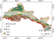
图1
河西地区地理位置"


图2
2000—2020年河西地区年均NPP变化"
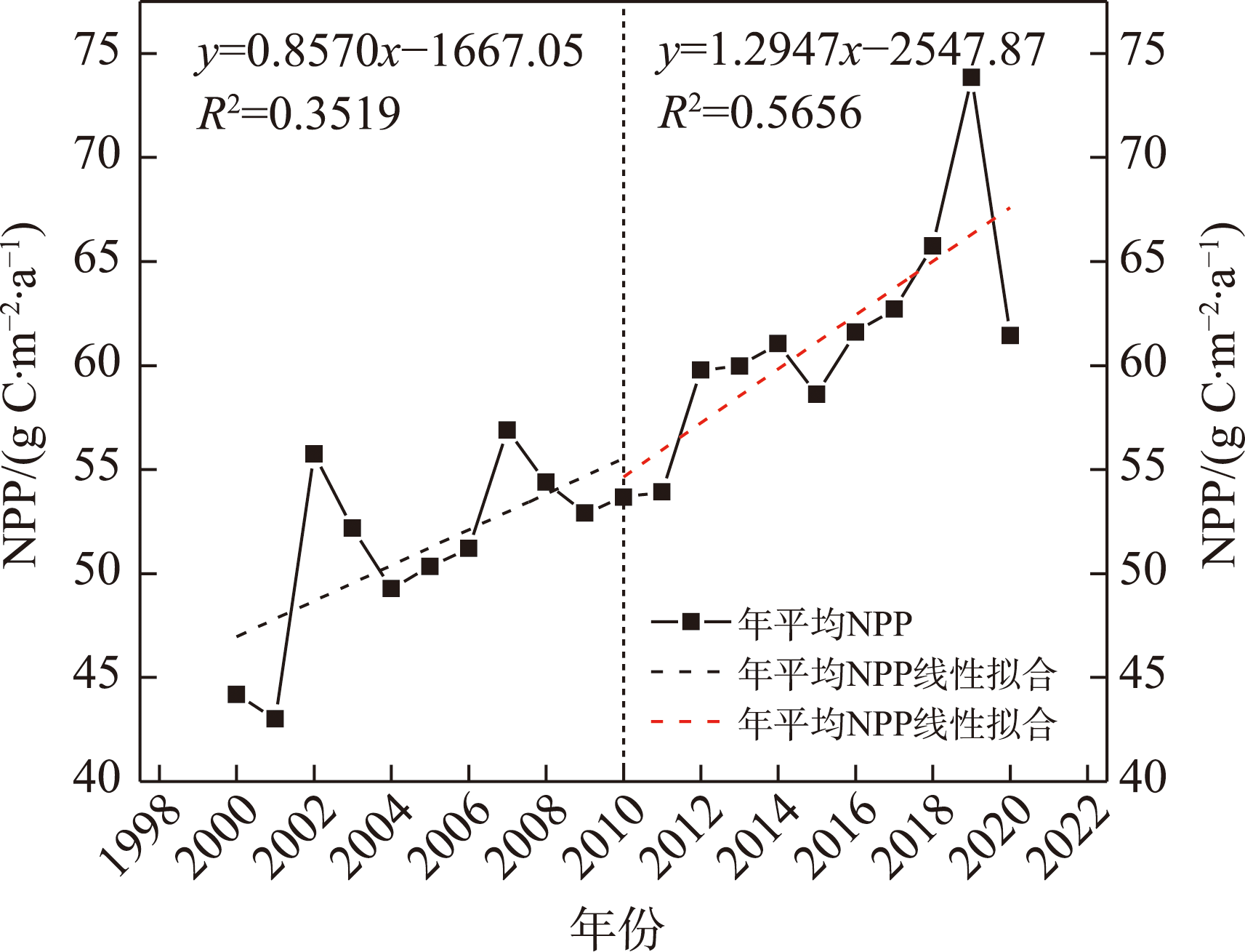
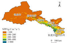
图3
2000—2020年河西地区平均植被NPP空间分布"

表1
2000—2020年河西地区各市(州)NPP统计"
| 市(州) | 不同等级年均NPP占比/% | 年均NPP /(g C·m-2·a-1) | 年NPP /(106 g C·m-2·a-1) | ||||
|---|---|---|---|---|---|---|---|
| <100 | 100~200 | 200~300 | 300~400 | ≥400 | |||
| 兰州* | 2.80 | 65.82 | 20.75 | 5.36 | 5.27 | 200.83 | 54.85 |
| 白银* | 15.02 | 75.05 | 7.11 | 2.57 | 0.25 | 135.18 | 32.94 |
| 临夏 | 1.07 | 23.20 | 67.68 | 6.31 | 1.75 | 232.59 | 8.59 |
| 武威 | 53.68 | 16.21 | 12.76 | 11.75 | 5.60 | 123.42 | 123.96 |
| 金昌 | 42.05 | 34.34 | 13.55 | 9.91 | 0.15 | 125.61 | 29.81 |
| 张掖 | 43.23 | 23.95 | 17.47 | 12.72 | 2.63 | 143.98 | 173.43 |
| 酒泉 | 96.77 | 2.49 | 0.50 | 0.24 | 0.00 | 7.07 | 37.84 |
| 嘉峪关 | 92.18 | 3.91 | 2.69 | 1.22 | 0.00 | 15.43 | 0.60 |
| 合计 | 76.53 | 12.36 | 5.91 | 3.96 | 1.24 | 984.11 | 462.02 |
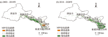
图4
河西地区植被净初级生产力变化趋势"

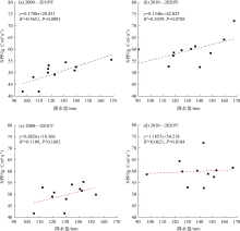
图5
2000—2020年河西地区植被净初级生产力、气温和降水散点图"


图6
2000年、2010年、2020年河西地区土地利用类型的空间分布"

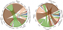
图7
2000—2020年河西地区土地利用/覆盖变化和弦图"

表2
不同时期土地利用类型的年平均净初级生产力"
| 年份 | 不同土地利用类型年平均净初级生产力/(g C·m-2·a-1) | |||||
|---|---|---|---|---|---|---|
| 耕地 | 林地 | 草地 | 水域 | 居民建筑用地 | 未利用土地 | |
| 2000年 | 166.60 | 228.88 | 72.27 | 53.66 | 134.94 | 7.56 |
| 2010年 | 195.93 | 280.28 | 90.83 | 69.93 | 157.97 | 9.72 |
| 2020年 | 228.72 | 298.92 | 105.57 | 78.13 | 156.05 | 10.57 |
| 平均 | 197.08 | 269.36 | 89.56 | 67.24 | 149.65 | 9.28 |
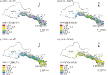
图8
2000—2020年河西地区植被净初级生产力与降水(a、b)和温度(c、d)的相关性"
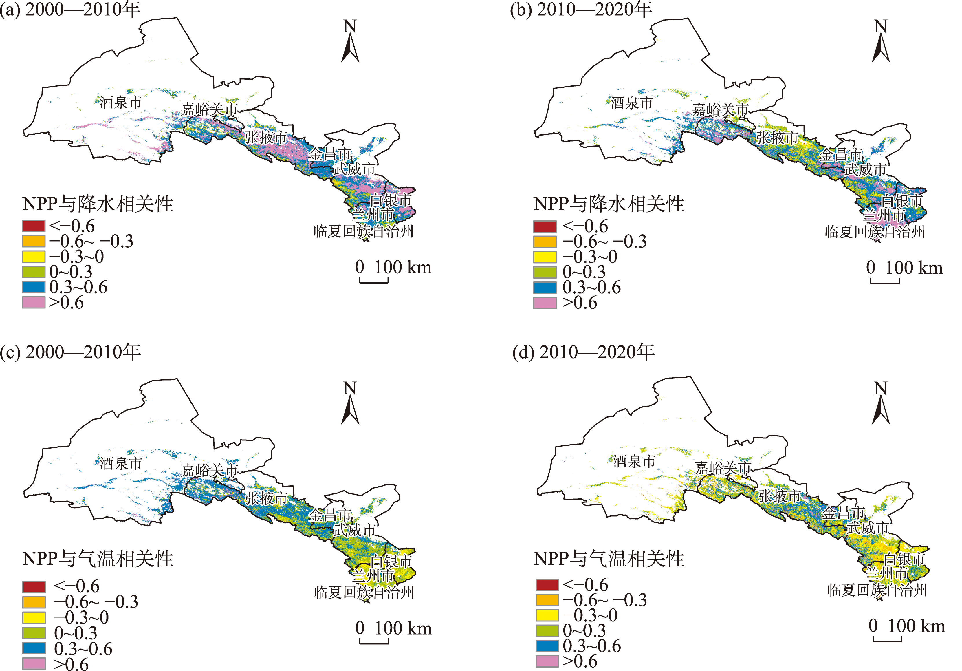
表3
不同土地利用类型对2000—2020年总植被净初级生产力的影响量和贡献率"
| 土地利用类型 | 影响因素 | 2000—2010年 | 2010—2020年 | |||
|---|---|---|---|---|---|---|
| 影响量/(Tg C) | 贡献率/% | 影响量/(Tg C) | 贡献率/% | |||
| 耕地 | 气候变化 | 56.39 | 73.78 | 66.42 | 90.49 | |
| LUCC | 17.04 | 22.28 | 5.98 | 8.15 | ||
| 林地 | 气候变化 | 43.82 | 99.68 | 15.89 | 98.69 | |
| LUCC | -0.11 | 0.26 | -0.19 | 1.24 | ||
| 草地 | 气候变化 | 125.26 | 99.85 | 99.55 | 96.97 | |
| LUCC | 0.15 | 0.12 | -2.59 | 2.69 | ||
| 水域 | 气候变化 | 4.23 | 97.70 | 2.12 | 76.21 | |
| LUCC | -0.07 | 1.80 | 0.59 | 21.28 | ||
| 居民建筑用地 | 气候变化 | 3.24 | 77.06 | -0.28 | 3.73 | |
| LUCC | -0.28 | 6.69 | 7.91 | 95.24 | ||
| 未利用土地 | 气候变化 | 38.64 | 97.26 | 15.20 | 95.84 | |
| LUCC | -0.83 | 2.19 | -0.58 | 3.99 | ||
| [1] |
Lang M, Kõlli R, Nikopensius M, et al. Assessment of MODIS NPP algorithm-based estimates using soil fertility and forest inventory data in mixed hemiboreal forests[J]. Forestry Studies, 2017, 66(1): 49-64.
doi: 10.1515/fsmu-2017-0006 |
| [2] | 程淑兰, 方华军, 徐梦, 等. 氮沉降增加情景下植物-土壤-微生物交互对自然生态系统土壤有机碳的调控研究进展[J]. 生态学报, 2018, 38(23): 8285-8295. |
| [Cheng Shulan, Fang Huajun, Xu Meng, et al. Regulation of plant-soil-microbe interactions to soil organic carbon in natural ecosystems under elevated nitrogen deposition: A review[J]. Acta Ecologica Sinica, 2018, 38(23): 8285-8295.] | |
| [3] |
赵苗苗, 刘熠, 杨吉林, 等. 基于HASM的中国植被NPP时空变化特征及其与气候的关系[J]. 生态环境学报, 2019, 28(2): 215-225.
doi: 10.16258/j.cnki.1674-5906.2019.02.001 |
|
[Zhao Miaomiao, Liu Yi, Yang Jilin, et al. Spatio-temporal patterns of NPP and its relations to climate in China based on HASM[J]. Ecology and Environmental Sciences, 2019, 28(2): 215-225.]
doi: 10.16258/j.cnki.1674-5906.2019.02.001 |
|
| [4] |
Zhang F G, Zeng B, Cao Y, et al. Human activities have markedly altered the pattern and trend of net primary production in the Ili River basin of northwest China under current climate change[J]. Land Degradation & Development, 2022, 33(14): 2585-2595.
doi: 10.1002/ldr.v33.14 |
| [5] |
Chen S F, Zhang Q F, Chen Y N, et al. Vegetation change and eco-environmental quality evaluation in the Loess Plateau of China from 2000 to 2020[J]. Remote Sensing, 2023, 15(2): 424.
doi: 10.3390/rs15020424 |
| [6] |
Chen X J, Mo X G, Hu S, et al. Contributions of climate change and human activities to ET and GPP trends over north China plain from 2000 to 2014[J]. Journal of Geographical Sciences, 2017, 27(6): 661-680.
doi: 10.1007/s11442-017-1399-z |
| [7] | 凡晚晴, 吴华, 樊风雷. 近20年来西藏地区NPP时空变化及影响因素[J]. 水土保持通报, 2022, 42(6): 378-386. |
| [Fan Wanqing, Wu Hua, Fan Fenglei. Spatial-temporal variation of net primary productivity and its influencing factors in Tibet over past 20 years[J]. Bulletin of Soil and Water Conservation, 2022, 42(6): 378-386.] | |
| [8] | 李飞, 赵军, 赵传燕, 等. 中国西北干旱区潜在植被模拟与动态变化分析[J]. 草业学报, 2011, 20(4): 42-50. |
| [Li Fei, Zhao Jun, Zhao Chuanyan, et al. Simulating and analyzing dynamic changes of potential vegetation in arid areas of Northwest China[J]. Acta Prataculturae Sinica, 2011, 20(4): 42-50.] | |
| [9] | 周广胜, 王玉辉. 全球变化与气候-植被分类研究和展望[J]. 科学通报, 1999, 44(24): 2587-2593. |
| [Zhou Guangsheng, Wang Yuhui. Global change and climate-vegetation classification research and perspectives[J]. Chinese Science Bulletin, 1999, 44(24): 2587-2593.] | |
| [10] | 王景升, 张宪洲, 赵玉萍, 等. 藏北羌塘高原气候变化的时空格局[J]. 资源科学, 2008, 30(12): 1852-1859. |
| [Wang Jingsheng, Zhang Xianzhou, Zhao Yuping, et al. Spatio-temporal pattern of climate changes in northern Tibet’s Qiangtang Plateau[J]. Resources Science, 2008, 30(12): 1852-1859.] | |
| [11] | 薛梅, 陈芸芝, 闫敏, 等. 中国东北地区植被NPP模拟与时空变化分析[J]. 福州大学学报(自然科学版), 2018, 46(6): 821-830. |
| [Xue Mei, Chen Yunzhi, Yan Min, et al. Simulation and spatio-temporal variation analysis of net primary productivity in Northeast China[J]. Journal of Fuzhou University (Natural Science Edition), 2018, 46(6): 821-830.] | |
| [12] | 孔春芳, 岳永财, 徐凯. 2000—2015年江汉平原区域植被NPP时空特征及其对气候变化的响应[J]. 长江流域资源与环境, 2019, 28(6): 1460-1469. |
| [Kong Chunfang, Yue Yongcai, Xu Kai. Spatial-temporal variation of vegetation net primary productivity and its response to climate change in Jianghan Plain from 2000 to 2015[J]. Resources and Environment in the Yangtze Basin, 2019, 28(6): 1460-1469.] | |
| [13] | 朴世龙, 方精云, 郭庆华. 利用CASA模型估算我国植被净第一性生产力[J]. 植物生态学报, 2001, 25(5): 603-608. |
| [Piao Shilong, Fang Jingyun, Guo Qinghua. Application of CASA model to the estimation of Chinese terrestrial net primary productivity[J]. Acta Phytoecologica Sinica, 2001, 25(5): 603-608.] | |
| [14] | 赵晓, 周文佐, 田罗, 等. 土地利用变化对三峡库区重庆段植被净初级生产力的影响[J]. 生态学报, 2018, 38(21): 7658-7668. |
| [Zhao Xiao, Zhou Wenzuo, Tian Luo, et al. Effects of land-use changes on vegetation net primary productivity in the Three Gorges Reservoir Area of Chongqing[J]. Acta Ecologica Sinica, 2018, 38(21): 7658-7668.] | |
| [15] | 彭月月, 魏妍冰, 李启权, 等. 气候和土地利用变化对成都市植被NPP时空分布的影响[J]. 西南大学学报(自然科学版), 2018, 40(11): 150-159. |
| [Peng Yueyue, Wei Yanbing, Li Qiquan, et al. The effects of changes in climate and land use on the spatio temporal distribution of vegetation NPP in Chengdu[J]. Journal of Southwest University (Natural Science Edition), 2018, 40(11): 150-159.] | |
| [16] | 蔡小青, 刘凤. 三江源区植被生产力时空格局及其变化特征[J]. 灌溉排水学报, 2021, 40(Suppl.): 56-59, 62. |
| [Cai Xiaoqing, Liu Feng. Spatiotemporal pattern and change characteristics of vegetation productivity in the Three River Headwaters[J]. Journal of Irrigation and Drainage, 2021, 40(Suppl.): 56-59, 62.] | |
| [17] |
Li J, Cui Y P, Liu J Y, et al. Estimation and analysis of net primary productivity by integrating MODIS remote sensing data with a light use efficiency model[J]. Ecological Modelling, 2013, 252: 3-10.
doi: 10.1016/j.ecolmodel.2012.11.026 |
| [18] |
Zhao L, Yang C H, Zhao Y C, et al. Spatial correlations of land use carbon emissions in Shandong peninsula urban agglomeration: A perspective from city level using remote sensing data[J]. Remote Sensing, 2023, 15(6): 1488.
doi: 10.3390/rs15061488 |
| [19] | 鲁晖, 董敬儒, 贺思嘉, 等. 2000—2017年河西地区山地-绿洲- 荒漠系统植被变化趋势与可持续性分析[J]. 兰州大学学报(自然科学版), 2021, 57(1): 99-108. |
| [Lu Hui, Dong Jingru, He Sijia, et al. Vegetation change trend and persistence analysis of the mountain-oasis-desert system in Hexi Region from 2000 to 2017[J]. Journal of Lanzhou University (Natural Sciences), 2021, 57(1): 99-108.] | |
| [20] | 窦睿音, 延军平, 王鹏涛. 全球变化背景下甘肃近半个世纪气温时空变化特征[J]. 干旱区研究, 2015, 32(1): 73-79. |
| [Dou Ruiyin, Yan Junping, Wang Pengtao. Spatiotemporal distribution of temperature in Gansu province under global climate change during the period from 1956 to 2012[J]. Arid Zone Research, 2015, 32(1): 73-79.] | |
| [21] | 王旭阳, 常跟应. 1998—2018年河西走廊农业生产地区专业化时空演变分析[J]. 兰州大学学报(自然科学版), 2022, 58(2): 186-194. |
| [Wang Xuyang, Chang Genying. Analysis of the spatio-temporal evolution of regional specialization of agriculture in the Hexi Corridor between 1998 and 2018[J]. Journal of Lanzhou University (Natural Sciences), 2022, 58(2): 186-194.] | |
| [22] | 戴尔阜, 方创琳. 甘肃河西地区生态问题与生态环境建设[J]. 干旱区资源与环境, 2002, 16(2): 1-5. |
| [Dai Erfu, Fang Chuanglin. Ecological problems and eco-environment construction in Hexi corridor Gansu Province[J]. Journal of Arid Land Resources and Environment, 2002, 16(2): 1-5.] | |
| [23] |
高振荣, 田庆明, 刘晓云, 等. 近58年河西走廊地区气温变化及突变分析[J]. 干旱区研究, 2010, 27(2): 194-203.
doi: 10.3724/SP.J.1148.2010.00194 |
|
[Gao Zhenrong, Tian Qingming, Liu Xiaoyun, et al. Characteristics and abrupt change of temperature in the Hexi corridor in recent 58 years[J]. Arid Zone Research, 2010, 27(2): 194-203.]
doi: 10.3724/SP.J.1148.2010.00194 |
|
| [24] | 谭淼, 周启刚. 2000—2015年典型山地区域净初级生产力时空分布特征[J]. 水土保持研究, 2019, 26(6): 339-346. |
| [Tan Miao, Zhou Qigang. Characteristics of spatial and temporal distribution of net primary productivity in Typical Mountain regions from 2000 to 2015[J]. Research of Soil and Water Conservation, 2019, 26(6): 339-346.] | |
| [25] |
Gabriel O, Paula P, Daniela F, et al. Remotely sensed primary productivity shows that domestic and native herbivores combined are overgrazing Patagonia[J]. Journal of Applied Ecology, 2019, 56(7): 1575-1584.
doi: 10.1111/1365-2664.13408 |
| [26] |
李登科, 王钊. 基于MOD17A3的中国陆地植被NPP变化特征分析[J]. 生态环境学报, 2018, 27(3): 397-405.
doi: 10.16258/j.cnki.1674-5906.2018.03.001 |
|
[Li Dengke, Wang Zhao. The characteristics of NPP of terrestrial vegetation in China based on MOD17A3 data[J]. Ecology and Environmental Sciences, 2018, 27(3): 397-405.]
doi: 10.16258/j.cnki.1674-5906.2018.03.001 |
|
| [27] |
Wang X L, Bao Y H. Study on the methods of land use dynamic change research[J]. Progress in Geography, 1999, 18(1): 81-87.
doi: 10.11820/dlkxjz.1999.01.012 |
| [28] | Hicke J A, Lobell D B, Asner G P. Cropland area and net primary production computed from 30 years of USDA agricultural harvest data[J]. Earth Interactions, 2004, 8(10): 1-20. |
| [29] |
Fu Y C, Lu X Y, Zhao Y, et al. Assessment impacts of weather and land use/land cover (LULC) change on urban vegetation net primary productivity (NPP): A case study in Guangzhou, China[J]. Remote Sensing, 2013, 5(8): 4125-4144.
doi: 10.3390/rs5084125 |
| [30] | Yue S, Wang C Y. Applicability of prewhitening to eliminate the influence of serial correlation on the Mann-Kendall test[J]. Water Resources Research, 2002, 38(6): 1068. |
| [31] | Aditya F, Gusmayanti E, Sudrajat J. Rainfall trend analysis using Mann-Kendall and Sen’s slope estimator test in west Kalimantan[J]. IOP Conference Series: Earth and Environmental Science, 2021, 893(1): 9. |
| [32] | 肖桐, 刘纪远, 邵全琴. 近20年青海三江源自然保护区植被生产力变化模拟[J]. 地球信息科学学报, 2009, 11(5): 5557-5565. |
| [Xiao Tong, Liu Jiyuan, Shao Quanqin. A simulation on changes in vegetation productivity in “Three River Sources” Nature Reserve, Qinghai province over past 20 years[J]. Journal of Geo-information Science, 2009, 11(5): 5557-5565.] | |
| [33] |
Shi S H, Zhu L P, Luo Z H, et al. Quantitative analysis of the contributions of climatic and anthropogenic factors to the variation in net primary productivity, China[J]. Remote Sensing, 2023, 15(3): 789.
doi: 10.3390/rs15030789 |
| [34] |
Huang Q, Zhang F Y, Zhang Q, et al. Assessing the effects of human activities on terrestrial net primary productivity of grasslands in typical ecologically fragile areas[J]. Biology, 2022, 12(1): 38.
doi: 10.3390/biology12010038 |
| [35] |
Yang Y S, Fan X M, Wang X, et al. Net primary productivity changes associated with landslides induced by the 2008 Wenchuan Earthquake[J]. Land Degradation & Development, 2022, 34(4): 1035-1050.
doi: 10.1002/ldr.v34.4 |
| [36] |
王凌阁, 朱睿, 陈泽霞, 等. 甘肃河西地区2000—2019年水土资源耦合协调特征[J]. 中国沙漠, 2022, 42(2): 44-53.
doi: 10.7522/j.issn.1000-694X.2021.00108 |
|
[Wang Lingge, Zhu Rui, Chen Zhexia, et al. Coupling effect of water-soil resources in Hexi area of Gansu, China in 2000-2019[J]. Journal of Desert Research, 2022, 42(2): 44-53.]
doi: 10.7522/j.issn.1000-694X.2021.00108 |
|
| [37] | 刘春雨, 董晓峰, 刘英英, 等. 甘肃省季节性净初级生产力变化特征[J]. 遥感信息, 2017, 32(5): 102-110. |
| [Liu Chunyu, Dong Xiaofeng, Liu Yingying, et al. Variation characteristics of seasonal net primary productivity in Gansu province[J]. Remote Sensing Information, 2017, 32(5): 102-110.] | |
| [38] | Peng D L, Huang J F, Huete Alfredo R, et al. Spatial and seasonal characterization of net primary productivity and climate variables in southeastern China using MODIS data[J]. Journal of Zhejiang University-Science B (Biomedicine & Biotechnology), 2010, 11(4): 275-285. |
| [39] |
Matsushita B, Tamura M. Integrating remotely sensed data with an ecosystem model to estimate net primary productivity in east Asia[J]. Remote Sensing of Environment, 2002, 81(1): 58-66.
doi: 10.1016/S0034-4257(01)00331-5 |
| [40] | 王莉雯, 卫亚星, 牛铮. 净初级生产力遥感估算模型空间尺度转换[J]. 遥感学报, 2010, 14(6): 1074-1089. |
| [Wang Liwen, Wei Yaxing, Niu Zheng. Spatial scaling of net primary productivity model based on remote sensing[J]. Journal of Remote Sensing, 2010, 14(6): 1074-1089.] | |
| [41] |
Jiang T, Wang X L, Afzal M M, et al. Vegetation productivity and precipitation use efficiency across the Yellow River Basin: Spatial patterns and controls[J]. Remote Sensing, 2022, 14(20): 5074.
doi: 10.3390/rs14205074 |
| [42] |
Zhao L, Chen Y Q, Wang X Y, et al. Spatiotemporal changes in net primary productivity before and after the development of unused land in the hilly areas of Hebei, China[J]. PloS One, 2022, 17(6): e0270010.
doi: 10.1371/journal.pone.0270010 |
| [43] | 李婷婷, 马超, 郭增长. 2004—2015年贺兰山自然保护区植被NPP时空变化与气候响应[J]. 水土保持研究, 2020, 27(6): 254-261. |
| [Li Tingting, Ma Chao, Guo Zengzhang. Response of spatiotemporal change of NPP to climate in Helanshan Mountain Nature Reserve from 2004 to 2015[J]. Research of Soil and Water Conservation, 2020, 27(6): 254-261.] |
| [1] | 李永广, 苑广辉. 青海湖流域不同下垫面类型对地表温度的生物物理影响[J]. 干旱区研究, 2024, 41(1): 24-35. |
| [2] | 马瑶瑶, 史培军, 徐伟, 张钢锋. 干旱区水电站建设运营生态环境影响遥感监测[J]. 干旱区研究, 2023, 40(9): 1498-1508. |
| [3] | 文妙霞, 何学高, 刘欢, 张婧, 罗晨, 贾丰铭, 王义贵, 胡云云. 基于地理探测器的宁夏草地植被覆被时空分异及驱动因子[J]. 干旱区研究, 2023, 40(8): 1322-1332. |
| [4] | 李虹, 李忠勤, 陈普晨, 彭加加. 近20 a新疆阿尔泰山积雪时空变化及其影响因素[J]. 干旱区研究, 2023, 40(7): 1040-1051. |
| [5] | 王士维, 孙栋元, 周敏, 王亦可, 王祥镔, 季宗虎, 张文睿, 武兰珍. 1951—2020年疏勒河流域气温时空变化特征[J]. 干旱区研究, 2023, 40(7): 1065-1074. |
| [6] | 赵卓怡, 郝兴明. 基于Priestley-Taylor方法的中亚干旱区实际蒸散特征及归因[J]. 干旱区研究, 2023, 40(7): 1085-1093. |
| [7] | 薛一波, 张小啸, 雷加强, 李生宇, 王永东, 尤源. 北非埃及地区风蚀沙尘时空变化研究[J]. 干旱区研究, 2023, 40(6): 896-904. |
| [8] | 陈加伟, 褚建民, 甘红豪, 徐磊, 公帅, 刘浩, 王迎新, 杨洪晓, 徐晓庆, 齐丹卉. 浑善达克沙地长梗扁桃群丛特征及其驱动因素分析[J]. 干旱区研究, 2023, 40(5): 777-784. |
| [9] | 任丽雯, 王兴涛, 刘明春, 王大为. 石羊河流域植被净初级生产力时空变化及驱动因素[J]. 干旱区研究, 2023, 40(5): 818-828. |
| [10] | 李鑫磊, 李瑞平, 王秀青, 王思楠, 王成坤. 基于地理探测器的河套灌区林草植被覆盖度时空变化与驱动力分析[J]. 干旱区研究, 2023, 40(4): 623-635. |
| [11] | 康利刚, 曹生奎, 曹广超, 杨羽帆, 严莉, 王有财. 青海湖沙柳河流域蒸散发时空变化特征[J]. 干旱区研究, 2023, 40(3): 358-372. |
| [12] | 王鹏, 秦思彤, 胡慧蓉. 近30 a拉萨河流域土地利用变化和生境质量的时空演变特征[J]. 干旱区研究, 2023, 40(3): 492-503. |
| [13] | 张恩月,郑君焱,苏迎庆,张蕾,张鹏飞,刘庚. 基于情景模拟的流域低碳土地利用格局优化研究——以汾河流域为例[J]. 干旱区研究, 2023, 40(2): 203-212. |
| [14] | 许丽婷,刘海红,黄丽洁,王钰帆. 2000—2020年汾河流域生态环境与水源涵养时空变化[J]. 干旱区研究, 2023, 40(2): 313-325. |
| [15] | 王怡恩, 饶良懿. 气候因素和人类活动对砒砂岩区植被净初级生产力的影响[J]. 干旱区研究, 2023, 40(12): 1982-1995. |
|
||