干旱区研究 ›› 2023, Vol. 40 ›› Issue (3): 492-503.doi: 10.13866/j.azr.2023.03.15
王鹏1( ),秦思彤2,胡慧蓉1()
收稿日期:2022-08-18
修回日期:2022-10-25
出版日期:2023-03-15
发布日期:2023-03-31
通讯作者:
胡慧蓉. E-mail: 作者简介:王鹏(1997-),男,硕士研究生,主要从事水土保持与荒漠化防治研究. E-mail: 基金资助:
WANG Peng1(),QIN Sitong2,HU Huirong1()
Received:2022-08-18
Revised:2022-10-25
Online:2023-03-15
Published:2023-03-31
摘要:
为明晰高原流域土地利用变化时空特征及其对生境质量的影响,以典型高原流域——拉萨河流域为例,基于GEE平台和随机森林分类算法,解译拉萨河流域1990—2020年土地利用信息,分析30 a间土地利用的时空动态变化特征,并结合InVEST模型评估流域生境质量,探讨流域生境质量变化特征。研究结果表明:针对高寒高海拔地区的土地利用分类问题,筛选植被生长季,用相邻年份的影像进行补充和替换缺失的数据,并去云后生成的年度合成影像,提高了地类分类效率和精度;建立了一种结合Landsat影像光谱特征、纹理特征和地形特征的最优RF分类模型,实现了对高原流域土地利用信息的提取,OA、Kappa系数和F1-score分别在88.16%、0.84和0.70以上;20世纪90年代以来,拉萨河流域土地利用变化特征整体表现为“五增三减”,草地、建设用地、林地、湿地和水域面积增加,耕地、冰川及永久积雪和未利用地面积减少,其中,建设用地的增长幅度最大,达到288.35%,而耕地缩减最多,达50.18%,且耕地减少主要是受到城镇范围扩张的挤占;未利用地面积减少最为显著,其转出部分主要转化为草地;研究期内高质量生境主要分布在流域下游、西南侧以及源头区域,以草地、水体、冰川及永久积雪和湿地等土地利用类型为主;而拉萨市市辖区、达孜区、林周县、曲水县和墨竹工卡县县城周边,以及流域中上游的未利用地等区域生境质量较差;流域整体生境质量呈“先减后增再减然后趋缓”的变化趋势,生境质量指数从0.53提升到0.57;人口增加和快速城镇化加快了城镇范围扩张和耕地的减少,但气候变化和生态治理工程对拉萨河流域的生境质量改善均起到了积极作用;本研究可为制定高原地区流域生态修复策略、促进土地利用可持续以及提升生境质量提供科学依据与参考。
王鹏, 秦思彤, 胡慧蓉. 近30 a拉萨河流域土地利用变化和生境质量的时空演变特征[J]. 干旱区研究, 2023, 40(3): 492-503.
WANG Peng, QIN Sitong, HU Huirong. Spatial-temporal evolution characteristics of land use change and habitat quality in the Lhasa River Basin over the past three decades[J]. Arid Zone Research, 2023, 40(3): 492-503.

图1
拉萨河流域概况及高分辨率影像验证样本点分布"

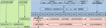
图2
技术路线"

表1
胁迫因子属性表"
| 胁迫因子 | 最大影响距离/km2 | 权重 | 衰减函数 |
|---|---|---|---|
| 耕地 | 6 | 0.7 | 线性 |
| 建设用地 | 10 | 1 | 指数 |
| 未利用地 | 5 | 0.3 | 指数 |
表2
不同土地利用类型的生境适宜度及其对胁迫因子的敏感度"
| 土地利用类型 | 生境适宜度 | 对胁迫因子的敏感度 | ||
|---|---|---|---|---|
| 耕地 | 建设用地 | 未利用地 | ||
| 冰川及永久积雪 | 1 | 0.6 | 0.8 | 0.3 |
| 草地 | 0.79 | 0.3 | 0.3 | 0.6 |
| 耕地 | 0.25 | 0.3 | 0.3 | 0.4 |
| 建设用地 | 0 | 0 | 0 | 0 |
| 林地 | 0.68 | 0.8 | 0.9 | 0.5 |
| 湿地 | 1 | 0.7 | 0.9 | 0.4 |
| 水体 | 1 | 0.8 | 0.8 | 0.3 |
| 未利用地 | 0 | 0 | 0 | 0 |
表3
分类精度"
| 土地利用类型 | 1990年 | 1995年 | 2000年 | 2005年 | 2010年 | 2015年 | 2020年 | |||||||||||||||||||
|---|---|---|---|---|---|---|---|---|---|---|---|---|---|---|---|---|---|---|---|---|---|---|---|---|---|---|
| PA | UA | PA | UA | PA | UA | PA | UA | PA | UA | PA | UA | PA | UA | |||||||||||||
| 水体 | 91.89 | 97.14 | 90.63 | 93.55 | 89.19 | 94.29 | 95.24 | 95.24 | 92.00 | 97.87 | 97.67 | 95.45 | 97.14 | 97.14 | ||||||||||||
| 林地 | 93.02 | 95.24 | 97.62 | 95.35 | 92.96 | 88.00 | 95.83 | 94.52 | 93.64 | 94.19 | 96.98 | 98.09 | 96.80 | 93.81 | ||||||||||||
| 草地 | 90.36 | 85.23 | 89.71 | 91.04 | 90.87 | 86.70 | 91.71 | 84.69 | 93.68 | 90.20 | 98.15 | 95.13 | 94.64 | 92.71 | ||||||||||||
| 耕地 | 91.11 | 89.13 | 88.89 | 90.24 | 78.23 | 94.87 | 80.77 | 93.33 | 88.37 | 90.48 | 89.87 | 98.61 | 84.38 | 94.74 | ||||||||||||
| 建设用地 | 75.00 | 82.46 | 90.00 | 69.23 | 82.35 | 93.33 | 92.00 | 95.83 | 90.00 | 96.43 | 90.91 | 78.96 | 87.88 | 96.67 | ||||||||||||
| 未利用地 | 96.34 | 89.77 | 98.48 | 92.86 | 91.67 | 86.43 | 93.96 | 93.44 | 95.53 | 94.38 | 97.27 | 95.03 | 95.31 | 95.81 | ||||||||||||
| 冰川及永久积雪 | 66.67 | 97.68 | 71.43 | 89.54 | 73.84 | 87.50 | 86.67 | 92.75 | 66.67 | 76.92 | 85.45 | 97.42 | 86.15 | 93.45 | ||||||||||||
| 湿地 | 79.31 | 92.00 | 83.33 | 89.28 | 70.83 | 89.47 | 78.13 | 87.68 | 81.08 | 93.75 | 94.74 | 92.31 | 90.00 | 88.52 | ||||||||||||
| OA | 90.50 | 92.78 | 88.16 | 91.22 | 92.72 | 96.19 | 93.78 | |||||||||||||||||||
| Kappa | 0.884 | 0.909 | 0.844 | 0.886 | 0.905 | 0.949 | 0.918 | |||||||||||||||||||

图3
1990—2020年拉萨河流域土地利用图谱"
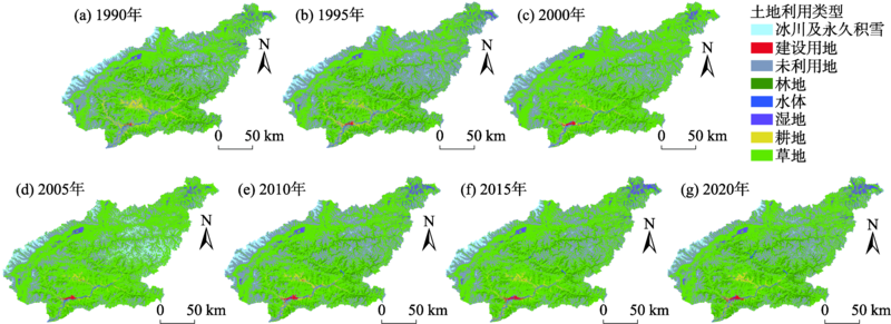
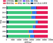
图4
1990—2020年拉萨河流域土地利用结构"
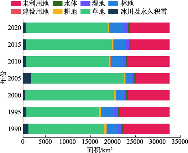
表4
不同时期拉萨河流域土地利用动态度指数"
| 土地利用类型 | 1990—1995年 | 1995—2000年 | 2000—2005年 | 2005—2010年 | 2010—2015年 | 2015—2020年 |
|---|---|---|---|---|---|---|
| 冰川及永久积雪 | -7.03 | -5.83 | 45.58 | -11.38 | -1.02 | -3.53 |
| 草地 | -0.74 | 4.43 | 0.95 | -2.26 | 0.72 | -0.82 |
| 耕地 | -6.13 | -6.07 | -1.39 | 3.84 | 1.47 | -2.68 |
| 建设用地 | 22.11 | 4.71 | 4.06 | 3.39 | 1.12 | 0.1 |
| 林地 | 1.94 | -7.75 | -4.14 | 17.85 | -0.54 | 4.4 |
| 湿地 | 4.23 | -8.28 | -0.57 | 12.55 | 2.92 | 1.83 |
| 水体 | 0.03 | 3.59 | -2.34 | -4.86 | 1.55 | 6.53 |
| 未利用地 | 1.53 | -3.29 | -3.84 | 4.89 | -1.53 | 0.52 |
| 综合土地利用动态度 | 2.95 | 3.35 | 3.35 | 3.56 | 1.99 | 2.00 |
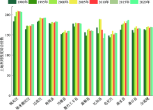
图5
全流域及各区(县)土地利用程度综合指数"

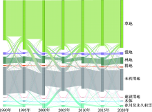
图6
1990—2020年拉萨河流域土地利用变化转移方向"

表5
1990—2020年拉萨河流域土地利用转移矩阵"
| 1990年 | 2020年 | ||||||||
|---|---|---|---|---|---|---|---|---|---|
| 冰川及永久积雪 | 草地 | 耕地 | 建设用地 | 林地 | 湿地 | 水体 | 未利用地 | 总计 | |
| 冰川及永久积雪 | - | 85.06 | 0 | 0 | 0.00 | 1.60 | 0.63 | 604.68 | 691.98 |
| 草地 | 45.99 | - | 50.24 | 28.96 | 762.01 | 433.41 | 49.78 | 420.29 | 1790.68 |
| 耕地 | 0 | 306.64 | - | 19.46 | 4.62 | 7.27 | 13.88 | 20.11 | 371.98 |
| 建设用地 | 0 | 2.92 | 0.93 | - | 0.03 | 0.14 | 1.44 | 1.09 | 6.55 |
| 林地 | 0 | 336.67 | 0.16 | 0.46 | - | 24.74 | 0.81 | 73.86 | 436.70 |
| 湿地 | 0 | 176.91 | 0.44 | 0.21 | 14.84 | - | 9.15 | 1.85 | 203.41 |
| 水体 | 2.46 | 32.54 | 3.12 | 3.17 | 1.33 | 14.72 | - | 38.03 | 95.36 |
| 未利用地 | 47.23 | 2301.56 | 33.38 | 19.38 | 173.85 | 5.80 | 54.36 | - | 2635.55 |
| 总计 | 95.68 | 3242.30 | 88.28 | 71.63 | 956.69 | 487.67 | 130.05 | 1159.91 | - |
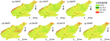
图7
1990—2020年拉萨河流域生境质量空间分布及其变化"

表6
1990—2020年生境质量等级转移矩阵"
| 时段 | 生境质量等级 | 差 | 一般 | 良好 | 优 |
|---|---|---|---|---|---|
| 1990—2000年 | 差 | - | 10.57 | 2166.61 | 125.04 |
| 一般 | 11.75 | - | 295.88 | 21.58 | |
| 良好 | 587.75 | 25.42 | - | 234.86 | |
| 优 | 699.25 | 1.06 | 491.33 | - | |
| 2000—2010年 | 差 | - | 18.10 | 835.27 | 310.36 |
| 一般 | 21.47 | - | 51.32 | 3.19 | |
| 良好 | 968.82 | 76.38 | - | 475.97 | |
| 优 | 248.65 | 11.30 | 115.19 | - | |
| 2010—2020年 | 差 | - | 27.75 | 1132.69 | 197.46 |
| 一般 | 18.71 | - | 98.06 | 4.95 | |
| 良好 | 564.91 | 65.17 | - | 394.84 | |
| 优 | 292.00 | 7.56 | 179.55 | - | |
| 1990—2020年 | 差 | - | 34.40 | 2497.44 | 110.28 |
| 一般 | 39.76 | - | 311.14 | 21.26 | |
| 良好 | 543.06 | 50.57 | - | 559.03 | |
| 优 | 648.76 | 3.59 | 315.85 | - |
| [1] | 周德志, 关颖慧, 张冰彬, 等. 基于土地利用变化的陕北地区生境质量时空演变及其驱动因素[J]. 北京林业大学学报, 2022, 44(6): 85-95. |
| [Zhou Dezhi, Guan Yinghui, Zhang Bingbin, et al. Spatial-temporal evolution of habitat quality and its driving factors in northern Shaanxi based on land use change[J]. Journal of Beijing Forestry University, 2022, 44(6): 85-95.] | |
| [2] |
He J, Huang J, Li C. The evaluation for the impact of land use change on habitat quality: A joint contribution of cellular automata scenario simulation and habitat quality assessment model[J]. Ecological Modelling, 2017, 366: 58-67.
doi: 10.1016/j.ecolmodel.2017.10.001 |
| [3] | 路亚方, 李红波. 2000-2020年基于土地利用变化的生境质量时空动态演变——以武汉城市圈为例[J]. 水土保持研究, 2022, 29(6): 391-398. |
| [Lu Yafang, Li Hongbo. Spatio-temporal dynamic evolution of habitat quality based on land use change from 2000 to 2020: Taking Wuhan metropolitan area as an example[J]. Research of Soil and Water Conservation, 2022, 29(6): 391-398.] | |
| [4] | 陈雪玲, 孙梅玲, 吕一河, 等. 青藏东缘若尔盖高原土地利用时空变化特征及其驱动因素分析[J/OL]. 生态与农村环境学报, 2023, 39(3): 306-315. |
| [Chen Xueling, Sun Meiling, Lv Yihe, et al. Spatio-temporal variation characteristics and driving factors of land use in Zoige Plateau, eastern margin of Qinghai-Tibet Plateau[J/OL]. Journal of Ecology and Rural Environment, 2023, 39(3): 306-315.] | |
| [5] | 陈伊多, 杨庆媛. 西藏自治区土地利用/覆被变化时空演变特征及驱动因素[J]. 水土保持学报, 2022, 36(5): 173-180. |
| [Chen Yiduo, Yang Qingyuan. Spatio-temporal evolution characteristics and driving factors of land use/cover change in Tibet Autonomous Region[J]. Journal of Soil and Water Conservation, 2022, 36(5): 173-180.] | |
| [6] | 彭海月, 任燕, 李琼, 等. 青藏高原土地利用/覆被时空变化特征[J]. 长江科学院院报, 2022, 39(8): 41-49, 57. |
| [Peng Haiyue, Ren Yan, Li Qiong, et al. Spatio-temporal variation characteristics of land use/cover in Tibetan Plateau[J]. Journal of Yangtze River Scientific Research Institute, 2022, 39(8): 41-49, 57.] | |
| [7] |
谭蕾, 杨桂山, 苏伟忠. 流域市场化生态补偿研究进展与展望[J]. 地理科学, 2022, 42(7): 1218-1228.
doi: 10.13249/j.cnki.sgs.2022.07.009 |
|
[Tan Lei, Yang Guishan, Su Weizhong. Research progress and prospect of basin marketization ecological compensation[J]. Scientia Geographical Sinica, 2022, 42(7): 1218-1228.]
doi: 10.13249/j.cnki.sgs.2022.07.009 |
|
| [8] | 王锦东, 苏海磊, 李会仙, 等. 典型流域生态完整性评价和应用研究进展[J]. 环境工程, 2022, 40(10): 233-241. |
| [Wang Jindong, Su Hailei, Li Huixian, et al. Research progress on ecological integrity assessment and application of typical watersheds[J]. Environmental Engineering, 2022, 40(10): 233-241.] | |
| [9] | 王静, 周绍昆, 孟繁林, 等. 土地利用演变对泸沽湖流域生态系统服务价值评估与时空变化的影响[J]. 西部林业科学, 2022, 51(5): 34-42. |
| [Wang Jing, Zhou Shaokun, Meng Fanlin, et al. Effects of land use change on ecosystem service value assessment and spatial-temporal change in Lugu Lake Basin[J]. Journal of West China Forestry Science, 2022, 51(5): 34-42.] | |
| [10] | 江康威, 张青青, 徐海量. 基于土地利用/覆被变化的依格孜牙河流域生态环境质量评估[J]. 中国农村水利水电, 2022, 62(11): 124-132, 140. |
| [Jiang Kangwei, Zhang Qingqing, Xu Hailiang. Eco-environmental quality assessment of Yigeziya River Basin based on land use/cover change[J]. China Rural Water and Hydropower, 2022, 62(11): 124-132, 140.] | |
| [11] | 杨桂山, 马荣华, 张路, 等. 中国湖泊现状及面临的重大问题与保护策略[J]. 湖泊科学, 2010, 22(6): 799-810. |
| [Yang Guishan, Ma Ronghua, Zhang Lu, et al. Current situation and major problems of lakes in China and protection strategies[J]. Journal of Lake Sciences, 2010, 22(6): 799-810.] | |
| [12] | 杨桂山, 徐昔保. 长江经济带“共抓大保护、不搞大开发”的基础与策略[J]. 中国科学院院刊, 2020, 35(8): 940-950. |
| [Yang Guishan, Xu Xibao. The foundation and strategy of the Yangtze River Economic Belt ‘to jointly protect and not engage in large-scale development’[J]. Bulletin of Chinese Academy of Sciences, 2020, 35(8): 940-950.] | |
| [13] | 王梦溪, 潘开文, 伍小刚, 等. 青藏高原耕地面积时空变化特征及其驱动因子[J]. 应用与环境生物学报, 2022, 28(4): 859-868. |
| [Wang Mengxi, Pan Kaiwen, Wu Xiaogang, et al. Spatio-temporal variation characteristics and driving factors of cultivated land area in Qinghai-Tibet Plateau[J]. Chinese Journal of Applied and Environmental Biology, 2022, 28(4): 859-868.] | |
| [14] |
Venkatappa M, Sasaki N, Shrestha R P, et al. Determination of vegetation thresholds for assessing land use and land use changes in Cambodia using the Google Earth Engine cloud-computing platform[J]. Remote Sensing, 2019, 11(13): 1514.
doi: 10.3390/rs11131514 |
| [15] | 刘东, 欧阳安, 陈聪, 等. 基于归一化植被指数的农田边界识别方法[J]. 江苏农业科学, 2022, 50(11): 196-201. |
| [Liu Dong, Ouyang An, Chen Cong, et al. Method of farmland boundary identification based on normalized difference vegetation index[J]. Jiangsu Agricultural Sciences, 2022, 50(11): 196-201.] | |
| [16] | 徐涵秋. 基于谱间特征和归一化指数分析的城市建筑用地信息提取[J]. 地理研究, 2005, 24(2): 311-320, 324. |
| [Xu Hanqiu. Urban construction land information extraction based on spectral characteristics and normalized index analysis[J]. Geographical Research, 2005, 24(2): 311-320, 324.] | |
| [17] | 李辉霞, 李森, 周红艺, 等. 基于NDWI的海南岛西部沙漠化信息自动提取方法研究[J]. 中国沙漠, 2006, 26(2): 215-219. |
| [Li Huixia, Li Sen, Zhou Hongyi, et al. Automatic extraction of desertification information in western Hainan Island based on NDWI[J]. Journal of Desert Research, 2006, 26(2): 215-219.] | |
| [18] | 刘元亮, 李艳, 吴剑亮. 基于LSWI和NDVI时间序列的水田信息提取研究[J]. 地理与地理信息科学, 2015, 31(3): 32-37, 2. |
| [Liu Yuanliang, Li Yan, Wu Jianliang. Research on paddy field information extraction based on LSWI and NDVI time series[J]. Geography and Geo-information Science, 2015, 31(3): 32-37, 2.] | |
| [19] | 刘丽, 匡纲要. 图像纹理特征提取方法综述[J]. 中国图象图形学报, 2009, 14(4): 622-635. |
| [Liu Li, Kuang Gangyao. Review of image texture feature extraction methods[J]. Journal of Image and Graphics, 2009, 14(4): 622-635.] | |
| [20] |
Tian S, Zhang X, Tian J, et al. Random forest classification of wetland landcovers from multi-sensor data in the arid region of Xinjiang, China[J]. Remote Sensing, 2016, 8(11): 954.
doi: 10.3390/rs8110954 |
| [21] | 邢瑾. 机器学习算法在高分辨率遥感影像土地覆被分类中的对比分析[J]. 甘肃科技, 2020, 36(3): 27-34. |
| [Xing Jin. Comparative analysis of machine learning algorithms in land cover classification of high-resolution remote sensing images[J]. Gansu Science and Technology, 2020, 36(3): 27-34.] | |
| [22] |
Ali S, Henchiri M, Sha Z, et al. A time series of land cover maps of South Asia from 2001 to 2015 generated using AVHRR GIMMS NDVI3g data[J]. Environmental Science and Pollution Research, 2020, 27(16): 20309-20320.
doi: 10.1007/s11356-020-08433-9 |
| [23] | 黄安东, 赵明松, 郜敏, 等. 1980-2020年安徽省土地利用时空演化特征[J]. 科学技术与工程, 2022, 22(11): 4627-4635. |
| [Huang Andong, Zhao Mingsong, Gao Min, et al. Spatial-temporal evolution characteristics of land use in Anhui Province from 1980 to 2020[J]. Science Technology and Engineering, 2022, 22(11): 4627-4635.] | |
| [24] | 朱会义, 李秀彬. 关于区域土地利用变化指数模型方法的讨论[J]. 地理学报, 2003, 70(5): 643-650. |
| [Zhu Huiyi, Li Xiubin. Discussion on the method of regional land use change index model[J]. Acta Geographica Sinica, 2003, 70(5): 643-650.] | |
| [25] | 税燕萍, 卢慧婷, 王慧芳, 等. 基于土地覆盖和NDVI变化的拉萨河流域生境质量评估[J]. 生态学报, 2018, 38(24): 8946-8954. |
| [Shui Yanping, Lu Huiting, Wang Huifang, et al. Habitat quality assessment of the Lhasa River Basin based on land cover and NDVI changes[J]. Acta Ecologica Sinica, 2018, 38(24): 8946-8954.] | |
| [26] | 潘耀, 尹云鹤, 侯文娟, 等. 基于土地利用及植被覆盖变化的黄河源区生境质量时空变化特征[J]. 生态学报, 2022, 42(19): 7978-7988. |
| [Pan Yao, Yin Yunhe, Hou Wenjuan, et al. Temporal and spatial variation characteristics of habitat quality in the source region of the Yellow River based on land use and vegetation cover change[J]. Acta Ecologica Sinica, 2022, 42(19): 7978-7988.] | |
| [27] |
朱杰, 龚健, 李靖业. 青藏高原东部生态敏感区生境质量时空演变特征——以青海省河湟谷地为例[J]. 资源科学, 2020, 42(5): 991-1003.
doi: 10.18402/resci.2020.05.16 |
|
[Zhu Jie, Gong Jian, Li Jingye. Spatial-temporal evolution characteristics of habitat quality in ecologically sensitive areas of eastern Qinghai-Tibet Plateau: A case study of Hehuang Valley in Qinghai Province[J]. Resources Science, 2020, 42(5): 991-1003.]
doi: 10.18402/resci.2020.05.16 |
|
| [28] | 杜军, 胡军, 建军, 等. 拉萨近半个世纪气温的年际和年代际变化[J]. 干旱区资源与环境, 2008, 22(10): 131-136. |
| [Du Jun, Hu Jun, Jian Jun, et al. Interannual and interdecadal variation of air temperature in Lhasa in recent half century[J]. Journal of Arid Land Resources and Environment, 2008, 22(10): 131-136.] | |
| [29] | 侯蒙京, 殷建鹏, 葛静, 等. 基于随机森林的高寒湿地地区土地覆盖遥感分类方法[J]. 农业机械学报, 2020, 51(7): 220-227. |
| [Hou Mengjing, Yin Jianpeng, Ge Jing, et al. Remote sensing classification method of land cover in alpine wetland area based on random forest[J]. Transactions of the Chinese Society of Agricultural Machinery, 2020, 51(7): 220-227.] |
| [1] | 刘一丹, 姚晓军, 李宗省, 胡家瑜. 气候变化和土地利用覆盖变化对河西地区植被净初级生产力的影响[J]. 干旱区研究, 2024, 41(1): 169-180. |
| [2] | 李永广, 苑广辉. 青海湖流域不同下垫面类型对地表温度的生物物理影响[J]. 干旱区研究, 2024, 41(1): 24-35. |
| [3] | 马瑶瑶, 史培军, 徐伟, 张钢锋. 干旱区水电站建设运营生态环境影响遥感监测[J]. 干旱区研究, 2023, 40(9): 1498-1508. |
| [4] | 申草,任宗萍,李鹏,王凯博,鲁克新,任正龑,魏小燕. 宁夏水土保持生态补偿优先区识别[J]. 干旱区研究, 2023, 40(9): 1527-1536. |
| [5] | 张晓敏, 张东梅, 张伟. 人类活动对额尔齐斯河流域碳储量的影响[J]. 干旱区研究, 2023, 40(8): 1333-1345. |
| [6] | 申红艳, 温婷婷, 赵仙荣, 冯晓莉. 基于多模式的青藏高原前冬降水预测性能评估[J]. 干旱区研究, 2023, 40(7): 1027-1039. |
| [7] | 包玉斌,王耀宗,路锋,刘自增,马大为,杨勇,吴娟,张永康. 六盘山区国土空间生态安全格局构建与分区优化[J]. 干旱区研究, 2023, 40(7): 1172-1183. |
| [8] | 关宇淇, 李广, 潘雪, 徐国荣, 魏星星, 刘昊, 吴江琪. 降雨频率对甘南尕海湿草甸土壤碳氮磷化学计量特征的影响[J]. 干旱区研究, 2023, 40(6): 916-925. |
| [9] | 邹易, 蒙吉军. 干旱区绿洲-城镇-荒漠景观演变及生态环境效应[J]. 干旱区研究, 2023, 40(6): 988-1001. |
| [10] | 吴玥葶, 郭利丹, 井沛然, 黄峰, 王浩轩. 中亚五国水-能源-粮食-生态耦合关系及时空分异[J]. 干旱区研究, 2023, 40(4): 573-582. |
| [11] | 陈实, 黄银兰, 金云翔. 退耕还林(草)工程实施前后黄河中游生境质量时空变化分析[J]. 干旱区研究, 2023, 40(3): 456-468. |
| [12] | 张恩月,郑君焱,苏迎庆,张蕾,张鹏飞,刘庚. 基于情景模拟的流域低碳土地利用格局优化研究——以汾河流域为例[J]. 干旱区研究, 2023, 40(2): 203-212. |
| [13] | 黄莹, 王素艳, 马阳, 王岱, 张雯, 王璠. 宁夏近60 a寒潮变化特征及其环流异常[J]. 干旱区研究, 2023, 40(11): 1718-1728. |
| [14] | 雷馨, 海新权. 祁连山地区土地利用变化对碳储量的影响及经济价值估算[J]. 干旱区研究, 2023, 40(11): 1845-1854. |
| [15] | 张志高, 孙梓欣, 张秀丽, 郭可欣, 李卓娅, 郝海姣, 蔡茂堂. 1960—2020年黄河流域气候生长季时空演变及成因分析[J]. 干旱区研究, 2023, 40(10): 1537-1546. |
|
||