干旱区研究 ›› 2023, Vol. 40 ›› Issue (3): 456-468.doi: 10.13866/j.azr.2023.03.12 cstr: 32277.14.AZR.20230312
陈实1( ),黄银兰1,金云翔2()
收稿日期:2022-09-22
修回日期:2022-10-27
出版日期:2023-03-15
发布日期:2023-03-31
作者简介:陈实(1987-),男,博士,讲师,主要从事资源与环境遥感研究. E-mail: 基金资助:
CHEN Shi1(),HUANG Yinlan1,JIN Yunxiang2()
Received:2022-09-22
Revised:2022-10-27
Published:2023-03-15
Online:2023-03-31
摘要:
科学认识生境质量的时空变化特征及其发展趋势,对黄河中游生态保护修复以及高质量发展具有重要的现实意义。本文基于1992—2020年欧洲航空航天局逐年的土地覆盖数据,采用InVEST模型估算生境质量,运用Sen+MK检验和Hurst指数分析方法,探究了退耕还林(草)工程实施前后黄河中游的生境质量时空变化和发展趋势。研究结果表明:(1) 整体上看,29 a来黄河中游地区生境质量整体较好,平均生境质量指数为0.652,但呈现小幅下降趋势(每10 a下降0.004),从局部上看,退耕还林(草)区生境质量呈现上升趋势(每10 a上升0.174),其中,2011—2020年上升趋势最为显著,10 a增加了0.656;(2) 2001—2020年黄河中游地区生境质量发生时空变化的趋势类型以明显降低为主,但从不同时间段的发展来看,2011—2020年较2001—2010年生境质量向好发展的面积增多,体现在退耕还林(草)区的生境质量上升;(3) 未来黄河中游地区生境质量发生时空变化趋势类型以明显降低和明显上升为主,且可持续性较强,明显降低区主要分布在汾渭平原以及城市集中发展区域,明显上升区主要位于山西省、陕西省以及内蒙古自治区三地交界片区。
陈实, 黄银兰, 金云翔. 退耕还林(草)工程实施前后黄河中游生境质量时空变化分析[J]. 干旱区研究, 2023, 40(3): 456-468.
CHEN Shi, HUANG Yinlan, JIN Yunxiang. Spatiotemporal changes of habitat quality before and after the implementation of Grain for Green Project in the middle reaches of the Yellow River[J]. Arid Zone Research, 2023, 40(3): 456-468.

图1
研究区示意图"
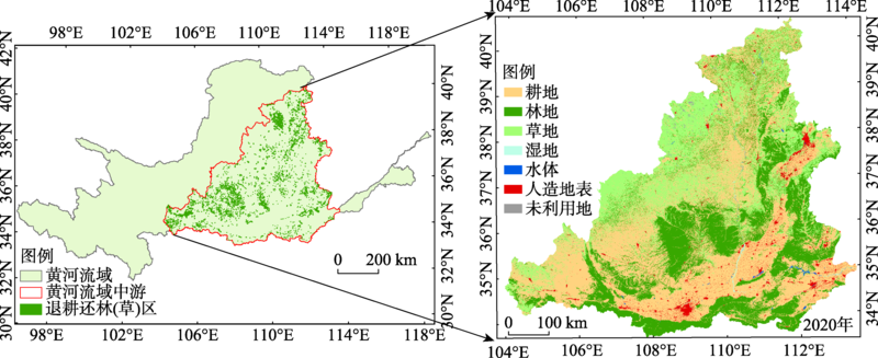
表1
各景观类型对生境威胁因子的敏感度"
| 土地利用/覆盖类型 | 生境适宜度 | 胁迫因子 | ||
|---|---|---|---|---|
| 耕地 | 人造地表 | 未利用地 | ||
| 耕地 | 0.3 | 0 | 0.8 | 0.4 |
| 林地 | 1 | 0.6 | 0.4 | 0.2 |
| 草地 | 1 | 0.8 | 0.6 | 0.6 |
| 湿地 | 0.9 | 0.6 | 0.7 | 0.4 |
| 水体 | 0.7 | 0.5 | 0.4 | 0.2 |
| 人造地表 | 0 | 0 | 0 | 0.1 |
| 未利用地 | 0.6 | 0.6 | 0.4 | 0 |
表2
威胁因子及其参数设置"
| 威胁因子 | 最大胁迫距离 | 权重 | 空间衰退类型 |
|---|---|---|---|
| 耕地 | 6 | 0.6 | 线性 |
| 人造地表 | 9 | 0.9 | 指数 |
| 未利用地 | 4 | 0.4 | 线性 |

图2
1992—2020年黄河中游(a)及退耕还林(草)区(b)生境质量变化趋势"
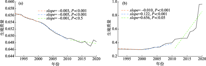
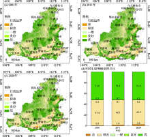
图3
不同时期黄河中游生境质量等级时空分布"


图4
生境质量变化类型空间分布"

表3
各时间段黄河中游生境质量变化趋势类型像元个数及百分比"
| 变化类型 | 2001—2020年 | 2001—2010年 | 2011—2020年 | |||||||
|---|---|---|---|---|---|---|---|---|---|---|
| 变化像元数/个 | 百分比% | 变化像元数/个 | 百分比% | 变化像元数/个 | 百分比% | |||||
| 明显降低 | 30026 | 80.71 | 37097 | 84.56 | 25391 | 57.49 | ||||
| 轻微降低 | 161 | 0.43 | 964 | 2.20 | 931 | 2.11 | ||||
| 轻微上升 | 2482 | 6.67 | 2086 | 4.76 | 10588 | 23.97 | ||||
| 明显上升 | 4534 | 12.19 | 3718 | 8.48 | 7258 | 16.43 | ||||
| 总计 | 37203 | 100.00 | 43865 | 100.00 | 44168 | 100.00 | ||||
表4
各时间段黄河中游退耕还林(草)区生境质量变化趋势类型像元个数及百分比"
| 变化类型 | 2001—2020年 | 2001—2010年 | 2011—2020年 | |||||||
|---|---|---|---|---|---|---|---|---|---|---|
| 变化像元数/个 | 百分比% | 变化像元数/个 | 百分比% | 变化像元数/个 | 百分比% | |||||
| 明显降低 | 0 | 0 | 4 | 0.28 | 25 | 0.52 | ||||
| 轻微降低 | 0 | 0 | 0 | 0 | 0 | 0 | ||||
| 轻微上升 | 1970 | 60.65 | 944 | 65.01 | 3867 | 80.50 | ||||
| 明显上升 | 1278 | 39.35 | 504 | 34.71 | 912 | 18.98 | ||||
| 总计 | 3248 | 100.00 | 1452 | 100.00 | 4804 | 100.00 | ||||
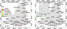
图5
2001—2020年生境质量时空变化趋势"

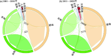
图6
黄河中游不同时期土地利用/覆盖类型转移"

| [1] | 杨洁, 谢保鹏, 张德罡. 黄河流域生境质量时空演变及其影响因素[J]. 中国沙漠, 2021, 41(4): 12-22. |
| [Yang Jie, Xie Baopeng, Zhang Degang. Spatial-temporal evolution of habitat quality and its influencing factors in the Yellow River Basin based on InVEST model and GeoDetector[J]. Journal of Desert Research, 2021, 41(4): 12-22.] | |
| [2] | 赵倩倩, 李建华, 张桂琴, 等. 气候变化背景下黄河流域植被变化及其成因[J]. 气候与环境研究, 2022, 27(1): 157-169. |
| [Zhao Qianqian, Li Jianhua, Zhang Guiqin, et al. Vegetation changes and their causes in the Yellow River Basin under the background of climate change[J]. Climatic and Environmental Research, 2022, 27(1): 157-169.] | |
| [3] |
李艳忠, 刘昌明, 刘小莽, 等. 植被恢复工程对黄河中游土地利用/覆被变化的影响[J]. 自然资源学报, 2016, 31(12): 2005-2020.
doi: 10.11849/zrzyxb.20160073 |
|
[Li Yanzhong, Liu Changming, Liu Xiaomang, et al. Impact of the Grain for Green Project on the Land Use/Cover change in the middle Yellow River[J]. Journal of Natural Resources, 2016, 31(12): 2005-2020.]
doi: 10.11849/zrzyxb.20160073 |
|
| [4] | 刘智方, 唐立娜, 邱全毅, 等. 基于土地利用变化的福建省生境质量时空变化研究[J]. 生态学报, 2017, 37(13): 4538-4548. |
| [Liu Zhifang, Tang Lina, Qiu Quanyi, et al. Temporal and spatial changes in habitat quality based on land-use change in Fujian Province[J]. Acta Ecologica Sinica, 2017, 37(13): 4538-4548.] | |
| [5] | 赵晓冏, 王建, 苏军德, 等. 基于InVEST模型和莫兰指数的甘肃省生境质量与退化度评估[J]. 农业工程学报, 2020, 36(18): 301-308. |
| [Zhao Xiaojiong, Wang Jian, Su Junde, et al. Assessment of habitat quality and degradation degree based on InVEST model and Moran index in Gansu Province, China[J]. Transactions of the Chinese Society of Agricultural Engineering, 2020, 36(18): 301-308.] | |
| [6] |
赵雪雁, 杜昱璇, 李花, 等. 黄河中游城镇化与生态系统服务耦合关系的时空变化[J]. 自然资源学报, 2021, 36(1): 131-147.
doi: 10.31497/zrzyxb.20210109 |
|
[Zhao Xueyan, Du Yuxuan, Li Hua, et al. Spatio-temporal changes of the coupling relationship between urbanization and ecosystem services in the Middle Yellow River[J]. Journal of Natural Resources, 2021, 36(1): 131-147.]
doi: 10.31497/zrzyxb.20210109 |
|
| [7] |
Weber D, Schaepman-Strub G, Ecker K. Predicting habitat quality of protected dry grasslands using Landsat NDVI phenology[J]. Ecological Indicators, 2018, 91: 447-460.
doi: 10.1016/j.ecolind.2018.03.081 |
| [8] |
Newbold T, Hudson L, Hill S, et al. Global effects of land use on local terrestrial biodiversity[J]. Nature, 2015, 520(7545): 45-50.
doi: 10.1038/nature14324 |
| [9] |
Terrado M, Sabater S, Chaplin-Kramer B, et al. Model development for the assessment of terrestrial and aquatic habitat quality in conservation planning[J]. Science of the Total Environment, 2016, 540: 63-70.
doi: 10.1016/j.scitotenv.2015.03.064 |
| [10] | 孙彦旭, 周自翔, 米朝娟. 基于土地利用覆被变化(LUCC)的人类活动与流域生物多样性灰色关联分析[J]. 干旱区研究, 2021, 38(6): 1782-1792. |
| [Sun Yanxu, Zhou Zixiang, Mi Zhaojuan. Grey correlation analysis of human activities and watershed biodiversity based on land use and cover change[J]. Arid Zone Research, 2021, 38(6): 1782-1792.] | |
| [11] |
Zhang X, Song W, Lang Y, et al. Land use changes in the coastal zone of China’s Hebei Province and the corresponding impacts on habitat quality[J]. Land Use Policy, 2020, 99: 104957.
doi: 10.1016/j.landusepol.2020.104957 |
| [12] | 黄木易, 岳文泽, 冯少茹, 等. 基于InVEST模型的皖西大别山区生境质量时空演化及景观格局分析[J]. 生态学报, 2020, 40(9): 2895-2906. |
| [Huang Muyi, Yue Wenze, Feng Shaoru, et al. Spatial-temporal evolution of habitat quality and analysis of landscape patterns in Dabie Mountain area of west Anhui province based on InVEST model[J]. Acta Ecologica Sinica, 2020, 40(9): 2895-2906.] | |
| [13] | 陈妍, 乔飞, 江磊. 基于InVEST 模型的土地利用格局变化对区域尺度生境质量的影响研究——以北京为例[J]. 北京大学学报(自然科学版), 2016, 52(3): 553-562. |
| [Chen Yan, Qiao Fei, Jiang Lei. Effects of land use pattern change on regional scale habitat quality based on InVEST Model: A case study in Beijing[J]. Acta Scientiarum Naturalium Universitatis Pekinensis, 2016, 52(3): 553-562.] | |
| [14] | 杨志鹏, 许嘉巍, 冯兴华, 等. 基于InVEST模型的东北地区土地利用变化对生境的影响研究[J]. 生态科学, 2018, 37(6): 139-147. |
| [Yang Zhipeng, Xu Jiawei, Feng Xinghua, et al. Effects of land use change on habitat based on InVEST model in Northeast China[J]. Ecological Science, 2018, 37(6): 139-147.] | |
| [15] |
吴健生, 曹祺文, 石淑芹, 等. 基于土地利用变化的京津冀生境质量时空演变[J]. 应用生态学报, 2015, 26(11): 3457-3466.
pmid: 26915203 |
|
[Wu Jiansheng, Cao Qiwen, Shi Shuqin, et al. Spatio-temporal variability of habitat quality in Beijing-Tianjin-Hebei Area based on land use change[J]. Chinese Journal of Applied Ecology, 2015, 26(11): 3457-3466.]
pmid: 26915203 |
|
| [16] | 彭建, 吴见, 徐飞雄, 等. 基于价值评估的黄山市生境质量时空演变特征分析[J]. 生态学报, 2021, 41(2): 665-679. |
| [Peng Jian, Wu Jian, Xu Feixiong, et al. Spatio-temporal evolution characteristics of habitat quality in typical tourism cities based on value evaluation: A case study of Huangshan[J]. Acta Ecologica Sinica, 2021, 41(2): 665-679.] | |
| [17] | 朱增云, 阿里木江·卡斯木. 基于地理探测器的伊犁谷地生境质量时空演变及其影响因素[J]. 生态学杂志, 2020, 39(10): 3408-3420. |
| [Zhu Zengyun, Alimujiang Ksim. Spatial-temporal evolution of habitat quality in Yili Valley based on geographical detector and its influencing factors[J]. Chinese Journal of Ecology, 2020, 39(10): 3408-3420.] | |
| [18] | 王军, 严有龙, 王金满, 等. 闽江流域生境质量时空演变特征与预测研究[J]. 生态学报, 2021, 41(14): 5837-5848. |
| [Wang Jun, Yan Youlong, Wang Jinman, et al. Temporal-spatial variation characteristics and prediction of habitat quality in Min River Basin[J]. Acta Ecologica Sinica, 2021, 41(14): 5837-5848.] | |
| [19] | 李宸宇, 朱建华, 郭学媛, 等. 长江经济带林业生态工程区生境质量时空变化[J]. 生态学杂志, 2021, 40(12): 3788-3799. |
| [Li Chenyu, Zhu Jianhua, Guo Xueyuan, et al. Spatiotemporal variations of habitat quality in forestry ecological project region of the Yangtze River Economic Belt[J]. Chinese Journal of Ecology, 2021, 40(12): 3788-3799.] | |
| [20] | 吴林霖, 王思远, 杨瑞霞, 等. 斯里兰卡亚洲象栖息地生境质量时空变化及分异特征[J]. 遥感学报, 2021, 25(12): 2472-2487. |
| [Wu Linlin, Wang Siyuan, Yang Ruixia, et al. Spatio-temporal patterns and differentiations of habitat quality for Asian elephant (Elephas maximus) habitat of Sri Lanka[J]. National Remote Sensing Bulletin, 2021, 25(12): 2472-2487.] | |
| [21] | 钟莉娜, 王军. 基于InVEST模型评估土地整治对生境质量的影响[J]. 农业工程学报, 2017, 33(1): 250-255. |
| [Zhong Linna, Wang Jun. Evaluation on effect of land consolidation on habitat quality based on InVEST model[J]. Transactions of the Chinese Society of Agricultural Engineering, 2017, 33(1): 250-255.] | |
| [22] | 王燕, 高吉喜, 金宇, 等. 基于2005—2015年土地利用变化和InVEST模型的内蒙古巴林右旗农牧交错带生境质量研究[J]. 生态与农村环境学报, 2020, 36(5): 654-662. |
| [Wang Yan, Gao Jixi, Jin Yu, et al. Habitat quality of farming-pastoral ecotone in Bairin Right Banner, Inner Mongolia based on land use change and InVEST Model from 2005 to 2015[J]. Journal of Ecology and Rural Environment, 2020, 36(5): 654-662.] | |
| [23] | 刘孟竹, 张红娟, 王彦芳, 等. 基于土地利用的北方农牧交错带生境质量研究[J]. 水土保持研究, 2021, 28(3): 156-162. |
| [Liu Mengzhu, Zhang Hongjuan, Wang Yanfang, et al. Characteristics of habitat quality in the agro-pastoral ecotone of northern China based on land uses[J]. Research of Soil and Water Conservation, 2021, 28(3): 156-162.] | |
| [24] | 包玉斌, 刘康, 李婷, 等. 基于InVEST模型的土地利用变化对生境的影响——以陕西省黄河湿地自然保护区为例[J]. 干旱区研究, 2015, 32(3): 622-629. |
| [Bao Yubin, Liu Kang, Li Ting, et al. Effects of land use change on habitat based on InVEST model: Taking Yellow River Wetland Nature Reserve in Shaanxi Province as an example[J]. Arid Zone Research, 2015, 32(3): 622-629.] | |
| [25] | 贾艳艳, 王少杰, 刘福胜, 等. 黄河三角洲高效生态经济区土地利用变化及其与生境质量的相关性[J]. 水土保持通报, 2020, 40(6): 213-220. |
| [Jia Yanyan, Wang Shaojie, Liu Fusheng, et al. Land use change and its correlation with habitat quality in high efficiencyeco-economic zone of Yellow River delta[J]. Bulletin of Soil and Water Conservation, 2020, 40(6): 213-220.] | |
| [26] | 周婷, 陈万旭, 李江风, 等. 神农架林区人类活动与生境质量的空间关系[J]. 生态学报, 2021, 41(15): 6134-6145. |
| [Zhou Ting, Chen Wanxu, Li Jiangfeng, et al. Spatial relationship between human activities and habitat quality in Shennongjia Forest Region from 1995 to 2015[J]. Acta Ecologica Sinica, 2021, 41(15): 6134-6145.] | |
| [27] |
林依雪, 李艳忠, 余文君, 等. 植被恢复工程对黄河中游12个典型流域水热平衡的影响研究[J]. 地理研究, 2020, 39(11): 2593-2606.
doi: 10.11821/dlyj020190744 |
|
[Lin Yixue, Li Yanzhong, Yu Wenjun, et al. Quantitative assessment of the impact of the vegetation restoration project on water-energy balance in 12 typical basins of the middle Yellow River[J]. Geographical Research, 2020, 39(11): 2593-2606.]
doi: 10.11821/dlyj020190744 |
|
| [28] |
赵安周, 张安兵, 刘海新, 等. 退耕还林(草)工程实施前后黄土高原植被覆盖时空变化分析[J]. 自然资源学报, 2017, 32(3): 449-460.
doi: 10.11849/zrzyxb.20160411 |
|
[Zhao Anzhou, Zhang Anbing, Liu Haixin, et al. Spatiotemporal variation of vegetation coverage before and after implementation of Grain for Green Project in the Loess Plateau[J]. Journal of Natural Resources, 2017, 32(3): 449-460.]
doi: 10.11849/zrzyxb.20160411 |
|
| [29] | 王晓峰, 杨丹, 冯晓明, 等. 黄河中游地区生态恢复对流域水资源的影响[J]. 水土保持通报, 2020, 40(6): 205-212. |
| [Wang Xiaofeng, Yang Dan, Feng Xiaoming, et al. Impacts of ecological restoration on water resources in middle reaches of Yellow River[J]. Bulletin of Soil and Water Conservation, 2020, 40(6): 205-212.] | |
| [30] | 张镱锂, 刘林山, 王兆锋, 等. 青藏高原土地利用与覆被变化的时空特征[J]. 科学通报, 2019, 64(27): 2865-2875. |
| [Zhang Yili, Liu Linshan, Wang Zhaofeng, et al. Spatial and temporal characteristics of land use and cover changes in the Tibetan Plateau[J]. Chinese Science Bulletin, 2019, 64(27): 2865-2875.] | |
| [31] | 李元春, 葛静, 侯蒙京, 等. 基于CCI-LC数据的甘南和川西北地区土地覆盖类型时空动态分布及草地面积变化驱动力研究[J]. 草业学报, 2020, 29(3): 1-15. |
| [Li Yuanchun, Ge Jing, Hou Mengjing, et al. A study of the spatiotemporal dymamic of land cover types and the driving forces of grassland area change in Gannan Prefecture and Northwest Sichuan based on CCI-LC data[J]. Acta Prataculturae Sinica, 2020, 29(3): 1-15.] | |
| [32] | 程琳琳, 黄婷, 刘焱序. 基于改进价值当量因子的1992-2015年青藏高原生态系统服务价值演化分析[J]. 水土保持通报, 2019, 39(5): 242-248. |
| [Cheng Linlin, Huang Ting, Liu Yanxu. Analysis on evolution of ecosystem service value in Qinghai-Tibet Plateau based on improved value equivalent factors from 1992 to 2015[J]. Bulletin of Soil and Water Conservation, 2019, 39(5): 242-248.] | |
| [33] | Riedler B, Lang S. A spatially explicit patch model of habitat quality, integrating spatio-structural indicators[J]. Ecological Indicators, 2018, 94: 8-14. |
| [34] |
谢余初, 巩杰, 张素欣, 等. 基于遥感和InVEST 模型的白龙江流域景观生物多样性时空格局研究[J]. 地理科学, 2018, 38(6): 979-986.
doi: 10.13249/j.cnki.sgs.2018.06.018 |
|
[Xie Yuchu, Gong Jie, Zhang Suxin, et al. Spatiotemporal change of landscape biodiversity based on InVEST Model and remote sensing technology in the Bailong River Watershed[J]. Scientia Geographica Sinica, 2018, 38(6): 979-986.]
doi: 10.13249/j.cnki.sgs.2018.06.018 |
|
| [35] | 张学儒, 周杰, 李梦梅. 基于土地利用格局重建的区域生境质量时空变化分析[J]. 地理学报, 2020, 75(1): 162-178. |
| [Zhang Xueru, Zhou Jie, Li Mengmei. Analysis on spatial and temporal changes of regional habitat quality based on the spatial pattern reconstruction of land use[J]. Journal of Geographical Sciences, 2020, 75(1): 160-178.] | |
| [36] | 刘洋, 李诚志, 刘志辉, 等. 1982—2013年基于GIMMS-NDVI的新疆植被覆盖时空变化[J]. 生态学报, 2016, 36(19): 6198-6208. |
| [Liu Yang, Li Chengzhi, Liu Zhihui, et al. Assessment of spatio-temporal variations in vegetation cover in Xinjiang from 1982 to 2013 based on GIMMS-NDVI[J]. Acta Ecologica Sinica, 2016, 36(19): 6198-6208.] | |
| [37] |
方利, 王文杰, 蒋卫国, 等. 2000-2014年黑龙江流域(中国)植被覆盖时空变化及其对气候变化的响应[J]. 地理科学, 2017, 37(11): 1745-1754.
doi: 10.13249/j.cnki.sgs.2017.11.017 |
|
[Fang Li, Wang Wenjie, Jiang Weiguo, et al. Spatio-temporal variations of vegetation cover and its responses to climate change in the Heilongjiang Basin of China from 2000 to 2014[J]. Scientia Geographica Sinica, 2017, 37(11): 1745-1754.]
doi: 10.13249/j.cnki.sgs.2017.11.017 |
|
| [38] |
侯西勇, 应兰兰, 高猛, 等. 1998-2008年中国东部沿海植被覆盖变化特征[J]. 地理科学, 2010, 30(5): 735-741.
doi: 10.13249/j.cnki.sgs.2010.05.735 |
|
[Hou Xiyong, Ying Lanlan, Gao Meng, et al. Character of vegetation cover change in China’s eastern coastal areas 1998-2008[J]. Scientia Geographica Sinica, 2010, 30(5): 735-741.]
doi: 10.13249/j.cnki.sgs.2010.05.735 |
|
| [39] | 国政, 王瑞永. 农民对退耕还林工程建设与管理的满意度分析——基于退耕还林工程实施前后(1980—2017年)典型示范区农户调查数据[J]. 社会科学, 2020, 42(3): 53-67. |
| [Guo Zheng, Wang Ruiyong. Analysis on farmers satisfaction with the construction and management of the grain for green project: Based on the survey daia of iarmers in typical demonstration areas before andafter the implementation of the grain for green project(1980-2017)[J]. Journal of Social Sciences, 2020, 42(3): 53-67.] | |
| [40] |
Guo S, Wu C, Wang Y, et al. Threshold effect of ecosystem services in response to climate change, human activity and landscape pattern in the upper and middle Yellow River of China[J]. Ecological Indicators, 2022, 136: 108603.
doi: 10.1016/j.ecolind.2022.108603 |
| [41] | 孙高鹏, 刘宪锋, 王小红, 等. 2001—2020年黄河流域植被覆盖变化及其影响因素[J]. 中国沙漠, 2021, 41(4): 205-212. |
| [Sun Gaopeng, Liu Xianfeng, Wang Xiaohong, et al. Changes in vegetation coverage and its influencing factors across the Yellow River Basin during 2001-2020[J]. Journal of Desert Research, 2021, 41(4): 205-212.] | |
| [42] | 赵广举, 穆兴民, 田鹏, 等. 黄土高原植被变化与恢复潜力预测[J]. 水土保持学报, 2021, 35(1): 205-212. |
| [Zhao Guangju, Mu Xingmin, Tian Peng, et al. Prediction of vegetation variation and vegetation restoration potential in the Loess Plateau[J]. Journal of Soil and Water Conservation, 2021, 35(1): 205-212.] | |
| [43] |
Yin D, Li X, Li G, et al. Spatio-temporal evolution of land use transition and its eco-environmental effects: A case study of the Yellow River Basin, China[J]. Land, 2020, 9(12): 514-514.
doi: 10.3390/land9120514 |
| [44] |
Song Y, Wang M, Sun X, et al. Quantitative assessment of the habitat quality dynamics in Yellow River Basin, China[J]. Environmental Monitoring and Assessment, 2021, 193(9): 614.
doi: 10.1007/s10661-021-09404-4 pmid: 34468858 |
| [45] |
方创琳. 黄河流域城市群形成发育的空间组织格局与高质量发展[J]. 经济地理, 2020, 40(6): 1-8.
doi: 10.2307/142170 |
|
[Fang Chuanglin. Spatial organization pattern and high-quality development of urban agglomeration in the Yellow River Basin[J]. Economic Geography, 2020, 40(6): 1-8.]
doi: 10.2307/142170 |
|
| [46] | 陈永国, 刘维军, 荣月静, 等. 基于土地利用与植被覆盖度的大通北川河源区自然保护区生境质量评估[J]. 水土保持研究, 2020, 27(6): 332-337. |
| [Chen Yongguo, Liu Weijun, Rong Yuejing, et al. Assessment on habitat quality of Datong Beichuan River source area nature reserve based on land use and vegetation coverage[J]. Research of Soil and Water Conservation, 2020, 27(6): 332-337.] |
| [1] | 袁征, 张志高, 闫瑾, 刘嘉毅, 胡柱钰, 王赟, 蔡茂堂. 1960—2020年黄河流域不同等级降水时空特征[J]. 干旱区研究, 2024, 41(8): 1259-1271. |
| [2] | 吴思源, 郝利娜. 2001—2021年黄河流域植被覆盖变化及其驱动因素[J]. 干旱区研究, 2024, 41(8): 1373-1384. |
| [3] | 张宏伟, 别强, 石莹, 苏晓杰, 李欣璋. 黄河流域上游植被覆盖变化特征及其影响因素[J]. 干旱区研究, 2024, 41(8): 1385-1394. |
| [4] | 吴朝巧, 林菲, 牛俊杰, 耿甜伟. 山西中部城市群生态系统服务对土地利用格局变化的响应[J]. 干旱区研究, 2024, 41(7): 1153-1166. |
| [5] | 李冰洁, 范志韬, 曲芷程, 姚顺予, 宿夏姝, 刘东伟, 王立新. 基于InVEST-PLUS模型的黄河流域内蒙古段生态系统碳储量评价及预测[J]. 干旱区研究, 2024, 41(7): 1217-1227. |
| [6] | 张顺鑫, 吴子豪, 闫庆武, 李桂娥, 牟守国. 基于PLUS-InVEST模型的天山北坡生态系统碳储量时空变化与预测[J]. 干旱区研究, 2024, 41(7): 1228-1237. |
| [7] | 高雅玉, 宋玉, 赵廷红, 高金芳, 何文博, 李泽霞. 马莲河下游产水量时空演变特征[J]. 干旱区研究, 2024, 41(5): 776-787. |
| [8] | 刘如龙, 赵媛媛, 陈国清, 迟文峰, 刘正佳. 内蒙古黄河流域1990—2020年生境质量评估[J]. 干旱区研究, 2024, 41(4): 674-683. |
| [9] | 徐铭璟, 冯强, 吕萌. 生态系统服务权衡及其影响因素——以黄河流域山西段为例[J]. 干旱区研究, 2024, 41(3): 467-479. |
| [10] | 李佳珂, 邵战林. 基于PLUS和InVEST模型的乌鲁木齐市碳储量时空演变与预测[J]. 干旱区研究, 2024, 41(3): 499-508. |
| [11] | 严莉, 曹广超, 康利刚, 刘梦琳, 叶得力. 基于InVEST模型的共和县生境质量时空变化及驱动因素[J]. 干旱区研究, 2024, 41(2): 314-325. |
| [12] | 王若凡, 刘雨欣, 李佩钢, 唐悦, 谢微. 黄河兰州段河岸带沉积物磷的形态分布及释放风险[J]. 干旱区研究, 2024, 41(12): 2035-2044. |
| [13] | 杨晓娟, 韩立新, 吕超. 环境条件对黄河流域植被干旱状态的影响特征分析[J]. 干旱区研究, 2024, 41(12): 2083-2093. |
| [14] | 王洋, 冯卓亚, 许丽, 高文信. 塔里木河流域生境质量与土地利用变化响应及驱动力[J]. 干旱区研究, 2024, 41(12): 2132-2142. |
| [15] | 陆莹, 张敏, 王彦阁. 内蒙古黄河流域生态保护恢复优先区识别[J]. 干旱区研究, 2024, 41(11): 1946-1955. |
|
||