干旱区研究 ›› 2024, Vol. 41 ›› Issue (4): 674-683.doi: 10.13866/j.azr.2024.04.13
刘如龙1,2( ), 赵媛媛1(), 陈国清2, 迟文峰3, 刘正佳4
收稿日期:2023-11-04
修回日期:2024-01-16
出版日期:2024-04-15
发布日期:2024-04-26
通讯作者:
赵媛媛. E-mail: 作者简介:刘如龙(2003-),男,硕士研究生,主要从事生态系统服务研究. E-mail: 1492904739@qq.com
基金资助:
LIU Rulong1,2(), ZHAO Yuanyuan1(), CHEN Guoqing2, CHI Wenfeng3, LIU Zhengjia4
Received:2023-11-04
Revised:2024-01-16
Online:2024-04-15
Published:2024-04-26
摘要:
内蒙古黄河流域是中国重要的生态区域,探究其生境质量变化能够为区域生态环境保护提供重要基础信息。本研究基于1990—2020年土地利用/覆盖数据,采用InVEST模型和地理探测器分析方法,揭示内蒙古黄河流域生境质量时空格局及其驱动力。结果表明:(1) 内蒙古黄河流域生境质量总体呈现北低南高的空间分布格局,具有显著的空间聚集性。生境质量等级为低的区域面积占比为23.50%,主要分布在库布齐沙漠以及研究区东南部;(2) 1990—2020年,研究区生境质量呈现先降低后小幅回升的变化趋势。生境质量退化的区域面积占比为11.97%,主要集中在研究区北部和黄河两岸附近,是耕地扩张和沙地分布区域;(3) 地形、植被和土壤类型等自然因子是生境质量空间分异特征的主要驱动因子,任意两种进行交互探测的因子对生境质量空间分异的解释力都要大于其单一因子的解释力。建议未来生态治理和恢复工作应重点关注研究区北部生境质量发生退化的区域,研究结果可为区域生物多样性的保护和生态环境的恢复提供借鉴和参考。
刘如龙, 赵媛媛, 陈国清, 迟文峰, 刘正佳. 内蒙古黄河流域1990—2020年生境质量评估[J]. 干旱区研究, 2024, 41(4): 674-683.
LIU Rulong, ZHAO Yuanyuan, CHEN Guoqing, CHI Wenfeng, LIU Zhengjia. Assessment of habitat quality in the Yellow River Basin in Inner Mongolia from 1990 to 2020[J]. Arid Zone Research, 2024, 41(4): 674-683.
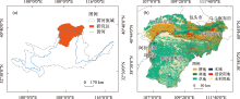
图1
研究区位置"

表1
生境威胁因子的影响范围及其权重"
| 威胁因子 | 影响范围 | 权重 |
|---|---|---|
| 工矿用地 | 9 | 0.9 |
| 旱地 | 5 | 0.6 |
| 城镇用地 | 10 | 1 |
| 农村居民点 | 7 | 0.7 |
表2
生境适宜度及其对不同威胁因子的相对敏感程度"
| 土地利用/ 覆盖类型 | 生境 适宜度 | 旱地 | 城镇 用地 | 农村 居民点 | 工矿 用地 |
|---|---|---|---|---|---|
| 水田 | 0.4 | 0.3 | 0.5 | 0.4 | 0.5 |
| 旱地 | 0.3 | 0 | 0.5 | 0.4 | 0.5 |
| 有林地 | 1 | 0.8 | 0.9 | 0.8 | 0.8 |
| 灌木林地 | 0.9 | 0.4 | 0.8 | 0.7 | 0.7 |
| 疏林地 | 0.8 | 0.85 | 0.9 | 0.8 | 0.8 |
| 其他林地 | 0.7 | 0.9 | 0.9 | 0.8 | 0.8 |
| 高覆盖度草地 | 0.9 | 0.4 | 0.6 | 0.5 | 0.6 |
| 中覆盖度草地 | 0.8 | 0.45 | 0.65 | 0.55 | 0.65 |
| 低覆盖度草地 | 0.7 | 0.5 | 0.7 | 0.6 | 0.7 |
| 河渠 | 0.9 | 0.65 | 0.85 | 0.75 | 0.8 |
| 湖泊 | 1 | 0.7 | 0.9 | 0.8 | 0.7 |
| 水库坑塘 | 0.8 | 0.7 | 0.9 | 0.8 | 0.7 |
| 永久性冰川雪地 | 1 | 0.7 | 0.85 | 0.75 | 0.7 |
| 滩涂 | 0.6 | 0.75 | 0.95 | 0.8 | 0.7 |
| 滩地 | 0.6 | 0.75 | 0.95 | 0.8 | 0.7 |
| 盐碱地 | 0.2 | 0.1 | 0.3 | 0.2 | 0.3 |
| 沼泽地 | 0.6 | 0.7 | 0.8 | 0.75 | 0.6 |

图2
2020年内蒙古黄河流域生境质量空间分布"


图3
2020年内蒙古黄河流域各县(区、旗)生境质量均值"


图4
1990—2020年内蒙古黄河流域各县(区、旗)生境质量变化"


图5
1990—2020年内蒙古黄河流域生境质量等级转移"

表3
各时段生境质量等级转移面积及其占比"
| 生境变化 | 面积/占比 | 1990—2000年 | 2000—2010年 | 2010—2020年 | 1990—2020年 |
|---|---|---|---|---|---|
| 改善 | 面积/km2 | 11195.46 | 5921.04 | 4730.17 | 15036.66 |
| 占比/% | 7.49 | 3.96 | 3.16 | 10.06 | |
| 不变 | 面积/km2 | 127369.62 | 134776.40 | 140207.41 | 116595.53 |
| 占比/% | 85.17 | 90.03 | 93.68 | 77.97 | |
| 退化 | 面积/km2 | 10983.78 | 9005.57 | 4730.53 | 17905.67 |
| 占比/% | 7.34 | 6.02 | 3.16 | 11.97 |
表4
生境质量驱动力探测结果"
| 驱动因子 | DEM | NDVI | 土壤类型 | 降水 | 气温 | 坡度 | GDP | 人口 |
|---|---|---|---|---|---|---|---|---|
| q值 | 0.074 | 0.062 | 0.050 | 0.036 | 0.024 | 0.015 | 0.007 | 0.006 |
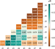
图6
生境质量驱动因子交互探测结果 注:X1为土壤类型,X2为NDVI,X3为DEM,X4为降水,X5为气温,X6为人口密度,X7为GDP,X8为坡度。"

| [1] |
陆大道, 孙东琪. 黄河流域的综合治理与可持续发展[J]. 地理学报, 2019, 74(12): 2431-2436.
doi: 10.11821/dlxb201912001 |
|
[Lu Dadao, Sun Dongqi. Comprehensive management and sustainable development of the Yellow River Basin[J]. Acta Geographica Sinica, 2019, 74(12): 2431-2436.]
doi: 10.11821/dlxb201912001 |
|
| [2] | 冯琰玮, 甄江红. 黄河流域内蒙古段生态安全格局优化研究[J]. 中国农业资源与区划, 2022, 43(10): 129-138. |
| [Feng Yanwei, Zhen Jianghong. Research on optimization of ecological security pattern in Inner Mongolia Section of the Yellow River Basin[J]. Chinese Journal of Agricultural Resources and Regional Planning, 2022, 43(10): 129-138.] | |
| [3] | Hall L S, Krausman P R, Morrison M L. The habitat concept and a plea for standard technology[J]. Wildlife Society Bulletin, 1997, 25(1). DOI: 10.230713783301. |
| [4] | 杜峯屹, 陈松林, 蒲佳豪. 2000—2020年闽东南地区土地利用变化及生境质量时空演变[J]. 水土保持研究, 2023, 30(6): 345-356. |
| [Du Fengyi, Chen Songlin, Pu Jiahao. Spatio-temporal evolution of land use change and habitat quality in southeastern Fujian from 2000 to 2020[J]. Research of Soil and Water Conservation, 2023, 30(6): 345-356.] | |
| [5] |
Erik N, Heather S, Peter H, et al. Projecting global land-use change and its effect on ecosystem service provision and biodiversity with simple models[J]. Plos One, 2010, 5(12): e14327.
doi: 10.1371/journal.pone.0014327 |
| [6] | Dai L, Li S, Lewis B J, et al. The influence of land use change on the spatial-temporal variability of habitat quality between 1990 and 2010 in Northeast China[J]. Journal of Forestry Research, 2019, 30(6): 251-260. |
| [7] | 王志强, 陈志超, 郝成元. 基于HSI模型的扎龙国家级自然保护区丹顶鹤繁殖生境适宜性评价[J]. 湿地科学, 2009, 7(3): 197-201. |
| [Wang Zhiqiang, Chen Zhichao, Hao Chengyuan. Habitat suitability evaluation of red-crowned crane breeding in Zhalong National Nature Reserve based on HSI model[J]. Wetland Science, 2009, 7(3): 197-201.] | |
| [8] | 白晓娟, 陈海, 刘迪, 等. 基于MaxEnt模型的生态系统服务需求及其簇的空间分异——以陕西省米脂县为例[J]. 生态学报, 2023, 43(7): 2745-2755. |
| [Bai Xiaojuan, Chen Hai, Liu Di, et al. Ecosystem service demand and spatial differentiation of its clusters based on MaxEnt model: A case study of Mizhi County, Shaanxi Province[J]. Acta Ecologica Sinica, 2023, 43(7): 2745-2755.] | |
| [9] | 李亚楠, 多玲花, 张明. 基于CA-Markov和InVEST模型的土地利用格局与生境质量时空演变及预测——以江西省南昌市为例[J]. 水土保持研究, 2022, 29(2): 345-354. |
| [Li Yanan, Duolinghua, Zhang Ming. The spatiotemporal evolution and prediction of land use pattern and habitat quality based on CA-Markov and InVEST models: A case study of Nanchang City, Jiangxi Province[J]. Research on Soil and Water Conservation, 2022, 29(2): 345-354.] | |
| [10] | 陈妍, 乔飞, 江磊. 基于InVEST模型的土地利用格局变化对区域尺度生境质量的影响研究——以北京为例[J]. 北京大学学报(自然科学版), 2016, 52(3): 553-562. |
| [Chen Yan, Qiao Fei, Jiang Lei. Effects of land use pattern change on regional scale habitat quality based on invest model:A case study in Beijing[J]. Acta Scientiarum Naturalium Universitatis Pekinensis, 2016, 52(3): 553-562.] | |
| [11] | 王琦琨, 武玮, 杨雪琪, 等. 陕西省生境质量时空演变及驱动机制分析[J]. 干旱区研究, 2022, 39(5): 1684-1694. |
| [Wang Qikun, Wu Wei, Yang Xueqi, et al. Analysis of spatiotemporal evolution and driving mechanisms of habitat quality in Shaanxi Province[J]. Arid Zone Research, 2022, 39(5): 1684-1694.] | |
| [12] |
Sallustio L, De Toni A, Strollo A, et al. Assessing habitat quality in relation to the spatial distribution of protected areas in Italy[J]. Journal of Environmental Management, 2017, 201: 129.
doi: S0301-4797(17)30613-8 pmid: 28651222 |
| [13] | 王鹏, 秦思彤, 胡慧蓉. 近30 a拉萨河流域土地利用变化和生境质量的时空演变特征[J]. 干旱区研究, 2023, 40(3): 492-503. |
| [Wang Peng, Qin Sitong, Hu Huirong. The spatiotemporal evolution characteristics of land use change and habitat quality in the Lhasa River Basin over the past 30 years[J]. Arid Zone Research, 2023, 40(3): 492-503.] | |
| [14] | 包玉斌, 刘康, 李婷, 等. 基于InVEST模型的土地利用变化对生境的影响——以陕西省黄河湿地自然保护区为例[J]. 干旱区研究, 2015, 32(3): 622-629. |
| [Bao Yubin, Liu Kang, Li Ting, et al. The impact of land use change on habitat based on the InVEST model: Taking the Yellow River Wetland Nature Reserve in Shaanxi Province as an example[J]. Arid Zone Research, 2015, 32(3): 622-629.] | |
| [15] | 李静, 李帅, 张英, 等. 2000—2020年黄河流域生物多样性维护功能时空变化及驱动分析[J]. 中国环境科学, 2023, 43(9): 4780-4790. |
| [Li Jing, Li Shuai, Zhang Ying, et al. Analysis of spatiotemporal changes and driving forces of biodiversity maintenance function in the Yellow River Basin from 2000 to 2020[J]. China Environmental Science, 2023, 43(9): 4780-4790.] | |
| [16] | 陈实, 黄银兰, 金云翔. 退耕还林(草)工程实施前后黄河中游生境质量时空变化分析[J]. 干旱区研究, 2023, 40(3): 456-468. |
| [Chen Shi, Huang Yinlan, Jin Yunxiang. Analysis of spatiotemporal changes in habitat quality in the middle reaches of the Yellow River before and after the implementation of the Grain for Green (Grassland) Project[J]. Arid Zone Research, 2023, 40(3): 456-468.] | |
| [17] | 齐松, 董春, 卫东, 等. 基于InVEST模型的黄河干流沿岸生境质量时空变化研究[J]. 测绘科学, 2022, 47(8): 114-122. |
| [Qi Song, Dong Chun, Wei Dong, et al. Study on the spatiotemporal changes of habitat quality along the Yellow River mainstream based on the InVEST model[J]. Science of Surveying and Mapping, 2022, 47(8): 114-122.] | |
| [18] | 徐新良, 刘纪远, 张树文, 等. 中国多时期土地利用土地覆被遥感监测数据集(CNLUCC)[DB/OL]. http://www.resdc.cn. [2023-3-25]. |
| [Xu Xinliang, Liu Jiyuan, Zhang Shuwen, et al. China multi-period land use land cover remote sensing monitoring data set[DB/OL]. http://www.resdc.cn. [2023-3-25]. ] | |
| [19] |
陈乐, 卫伟. 西北旱区典型流域土地利用与生境质量的时空演变特征[J]. 生态环境学报, 2022, 31(9): 1909-1918.
doi: 10.16258/j.cnki.1674-5906.2022.09.022 |
| [Chen Le, Wei Wei. The spatiotemporal evolution characteristics of land use and habitat quality in typical arid watersheds in Northwest China[J]. Ecology and Environmental Sciences, 2022, 31(9): 1909-1918.] | |
| [20] | 奥勇, 蒋嶺峰, 白召弟, 等. 基于格网GIS的黄河流域土地生态质量综合评价[J]. 干旱区地理, 2022, 45(1): 164-175. |
| [Ao Yong, Jiang Lingfeng, Bai Zhaodi, et al. Comprehensive evaluation of land ecological quality in the Yellow River Basin based on grid GIS[J]. Arid Land Geography, 2022, 45(1): 164-175.] | |
| [21] | 李亚娇, 沈昞昕, 李家科, 等. 丹汉江流域生境质量对景观格局变化响应[J]. 环境科学与技术, 2022, 45(5): 206-216. |
| [Li Yajiao, Shen Bingxin, Li Jiake, et al. The response of habitat quality to landscape pattern changes in the Danhan River Basin[J]. Environmental Science and Technology, 2022, 45(5): 206-216.] | |
| [22] |
Wang J F, Li X H, Christakos G, et al. Geographical detectors- based health risk assessment and its application in the neural tube defects study of the Heshun Region, China[J]. International Journal of Geographical Information Science, 2010, 24(1): 107-127.
doi: 10.1080/13658810802443457 |
| [23] |
王劲峰, 徐成东. 地理探测器:原理与展望[J]. 地理学报, 2017, 72(1): 116-134.
doi: 10.11821/dlxb201701010 |
|
[Wang Jinfeng, Xu Chengdong. Geographic detectors: Principles and prospects[J]. Acta Geographica Sinica, 2017, 72(1): 116-134.]
doi: 10.11821/dlxb201701010 |
|
| [24] |
John J, Chithra N R, Thampi S G. Prediction of land use/cover change in the Bharathapuzha river basin, India using geospatial techniques[J]. Environmental Monitoring and Assessment, 2019, 191(6): 1-15.
doi: 10.1007/s10661-018-7122-4 |
| [25] |
雷金睿, 陈毅青, 陈宗铸, 等. 基于InVEST模型的海南岛三大流域生境质量时空演变[J]. 应用生态学报, 2022, 33(9): 2511-2520.
doi: 10.13287/j.1001-9332.202209.019 |
|
[Lei Jinrui, Chen Yiqing, Chen Zongzhu, et al. Spatio-temporal evolution of habitat quality in three major watersheds of Hainan Island based on InVEST model[J]. Chinese Journal of Applied Ecology, 2022, 33(9): 2511-2520.]
doi: 10.13287/j.1001-9332.202209.019 |
|
| [26] |
Ma Libang, Bo Jie, Li Xiaoyang, et al. Identifying key landscape pattern indices influencing the ecological security of inland river basin: The middle and lower reaches of Shule River Basin as an example[J]. Science of the Total Environment, 2019, 674: 424-438.
doi: 10.1016/j.scitotenv.2019.04.107 |
| [27] | 田雅楠, 马龙, 吴全. 黄河流域内蒙古段土地利用演变与景观生态风险评价[J]. 生态科学, 2023, 42(5): 103-113. |
| [Tian Yanan, Ma Long, Wu Quan. Land use evolution and landscape ecological risk assessment in Inner Mongolia section of the Yellow River Basin[J]. Ecological Science, 2023, 42(5): 103-113.] | |
| [28] |
Terrado M, Sabater S, Chaplin-Kramer B, et al. Model development for the assessment of terrestrial and aquatic habitat quality in conservation planning[J]. Science of the Total Environment, 2016, 540: 63-70.
doi: 10.1016/j.scitotenv.2015.03.064 |
| [29] |
Song S, Liu Z, He C, et al. Evaluating the effects of urban expansion on natural habitat quality by coupling localized shared socioeconomic pathways and the land use scenario dynamics-urban model[J]. Ecological Indicators, 2020, 112: 106071.
doi: 10.1016/j.ecolind.2020.106071 |
| [30] | 杨永, 李瑞红, 刘航, 等. 东北农林交错区生境质量时空演变及归因分析[J/OL]. 生态学杂志, 2023-11-24. |
| [Yang Yong, Li Ruihong, Liu Hang, et al. The spatiotemporal evolution and attribution analysis of habitat quality in the agricultural and forestry transitional zone of Northeast China[J/OL]. Chinese Journal of Ecology, 2023-11-24. ] | |
| [31] | 施智勇, 谢慧黎, 王圳峰, 等. 基于参数最优地理探测器的福州市生境质量时空格局与驱动力分析[J]. 环境工程技术学报, 2023, 13(5): 1921-1930. |
| [Shi Zhiyong, Xie Huili, Wang Zhenfeng, et al. Analysis of spatiotemporal patterns and driving forces of habitat quality in Fuzhou city based on parameter optimal geographic detectors[J]. Journal of Environmental Engineering Technology, 2023, 13(5): 1921-1930.] | |
| [32] | 苏军德, 赵晓冏, 李国霞, 等. 祁连山国家自然保护区生境质量时空特征及驱动因素分析[J/OL]. 中国环境科学, 2023-12-12. |
| [Su Junde, Zhao Xiaojiong, Li Guoxia, et al. Analysis of spatiotemporal characteristics and driving factors of habitat quality in Qilian Mountain National Nature Reserve[J/OL]. China Environmental Science, 2023-12-12. ] |
| [1] | 李文秀, 燕振刚. 基于地理探测器的甘肃农牧交错带土地利用时空演化及其驱动机制[J]. 干旱区研究, 2024, 41(4): 590-602. |
| [2] | 裴志林, 曹晓娟, 王冬, 李迪, 王鑫, 白艾原. 内蒙古植被覆盖时空变化特征及其对人类活动的响应[J]. 干旱区研究, 2024, 41(4): 629-638. |
| [3] | 王鑫, 海山. 基于能值分析的典型农牧交错带可持续发展规模研究——以内蒙古乌兰察布市为例[J]. 干旱区研究, 2024, 41(4): 706-715. |
| [4] | 陶际峰, 包玉龙, 郭恩亮, 金额尔德木吐, 呼斯乐, 包玉海. 近40 a内蒙古冬旱时空演变特征[J]. 干旱区研究, 2024, 41(3): 387-398. |
| [5] | 徐铭璟, 冯强, 吕萌. 生态系统服务权衡及其影响因素——以黄河流域山西段为例[J]. 干旱区研究, 2024, 41(3): 467-479. |
| [6] | 李佳珂, 邵战林. 基于PLUS和InVEST模型的乌鲁木齐市碳储量时空演变与预测[J]. 干旱区研究, 2024, 41(3): 499-508. |
| [7] | 程秋连, 刘杰, 杨治纬, 张天意, 王斌. 独库高速阿尔先沟段雪崩空间分布及因子探测[J]. 干旱区研究, 2024, 41(2): 220-229. |
| [8] | 许宁, 李治国, 梁雪悦, 周晓莹. 基于地形梯度的青藏高原冰川分布格局及成因[J]. 干旱区研究, 2024, 41(2): 230-239. |
| [9] | 严莉, 曹广超, 康利刚, 刘梦琳, 叶得力. 基于InVEST模型的共和县生境质量时空变化及驱动因素[J]. 干旱区研究, 2024, 41(2): 314-325. |
| [10] | 衣娜娜, 苏立娟, 郑旭程, 辛悦, 蔡敏, 李慧, 靳雨晨. 冰雹天气的环境参量及预报模型[J]. 干旱区研究, 2024, 41(1): 13-23. |
| [11] | 申草,任宗萍,李鹏,王凯博,鲁克新,任正龑,魏小燕. 宁夏水土保持生态补偿优先区识别[J]. 干旱区研究, 2023, 40(9): 1527-1536. |
| [12] | 张晓敏, 张东梅, 张伟. 人类活动对额尔齐斯河流域碳储量的影响[J]. 干旱区研究, 2023, 40(8): 1333-1345. |
| [13] | 包玉斌,王耀宗,路锋,刘自增,马大为,杨勇,吴娟,张永康. 六盘山区国土空间生态安全格局构建与分区优化[J]. 干旱区研究, 2023, 40(7): 1172-1183. |
| [14] | 齐润泽, 潘竟虎. 河湟地区生态脆弱性时空演变及影响因素研究[J]. 干旱区研究, 2023, 40(6): 1002-1013. |
| [15] | 刘笑, 郭鹏, 祁佳峰, 杜文玲, 张茹倩, 张坤. 基于MRSEI模型的阿勒泰市生态环境时空变化及驱动力分析[J]. 干旱区研究, 2023, 40(6): 1014-1026. |
|
||