干旱区研究 ›› 2024, Vol. 41 ›› Issue (5): 776-787.doi: 10.13866/j.azr.2024.05.06
高雅玉1( ), 宋玉1, 赵廷红1(), 高金芳2, 何文博1, 李泽霞2
收稿日期:2023-12-13
修回日期:2024-01-30
出版日期:2024-05-15
发布日期:2024-05-29
通讯作者:
赵廷红. E-mail: 作者简介:高雅玉(1985-),女,正高级工程师,博士,主要从事水资源与水土保持方面的研究工作. E-mail: gyy@lut.edu.cn
基金资助:
GAO Yayu1(), SONG Yu1, ZHAO Tinghong1(), GAO Jinfang2, HE Wenbo1, LI Zexia2
Received:2023-12-13
Revised:2024-01-30
Online:2024-05-15
Published:2024-05-29
摘要:
马莲河下游流域是我国陇东典型的黄土高原沟壑区,在气候和土地利用变化背景下研究其产水量的时空特征和变化响应,对区域生态系统可持续发展具有重要意义。基于InVEST (Integrated Valuation of Ecosystem Services and Trade-offs)模型定量评估1990年、2000年、2010年和2020年4个时期马莲河下游流域产水量的时空格局和变化,运用地理探测器分析影响因子对产水功能空间分异的影响程度。结果表明:(1) 1990—2020年,马莲河下游流域总产水量整体呈现先减后增再减的变化趋势,2020年总产水量相比1990年减少了5.9×10⁷ m3,减少率为25.43%。不同时期产水量在空间上呈现南部和边缘地带高、北部和中心地带低的分布特征。(2) 不同土地利用类型产水能力大小排序依次为:城镇用地>未利用地>耕地>低覆盖度草地>高覆盖度草地>灌木林>有林地>水域。(3) 产水量与降水量呈现明显的正相关,与实际蒸散发量和海拔之间存在负相关。降水和实际蒸散发是决定产水量空间分布和变化的主导因素,q值分别为0.616~0.735和0.517~0.653。研究成果可为陇东黄土高原沟壑区水土资源开发、利用和管理提供科学支撑。
高雅玉, 宋玉, 赵廷红, 高金芳, 何文博, 李泽霞. 马莲河下游产水量时空演变特征[J]. 干旱区研究, 2024, 41(5): 776-787.
GAO Yayu, SONG Yu, ZHAO Tinghong, GAO Jinfang, HE Wenbo, LI Zexia. Spatiotemporal evolution of water yield in the lower Malian River Basin[J]. Arid Zone Research, 2024, 41(5): 776-787.
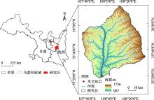
图1
研究区概况 注:底图采用自然资源部标准地图制作,审图号为GS(2016)1600号,对底图边界无修改。下同。"

表1
生物物理系数"
| 土地利用编号 | 土地利用 类型 | 植被蒸散系数 | 植物最大根系深度/mm | 属性类别 |
|---|---|---|---|---|
| 1 | 耕地 | 0.65 | 400 | 1 |
| 2 | 有林地 | 0.95 | 3000 | 1 |
| 3 | 灌木林 | 0.9 | 2500 | 1 |
| 4 | 高覆盖度草地 | 0.65 | 500 | 1 |
| 5 | 低覆盖度草地 | 0.6 | 450 | 1 |
| 6 | 水域 | 0.9 | 1 | 0 |
| 7 | 城镇用地 | 0.3 | 1 | 0 |
| 8 | 未利用地 | 0.5 | 100 | 0 |
表2
1990—2020年马莲河下游流域模拟产水量与实测径流量"
| 年份 | ||||
|---|---|---|---|---|
| 1990年 | 2000年 | 2010年 | 2020年 | |
| 实测径流量/mm | 42.71 | 25.68 | 36.01 | 31.76 |
| 模拟产水量/mm | 43.29 | 26.66 | 37.52 | 32.31 |
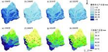
图2
马莲河下游流域产水量空间分布格局"

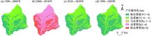
图3
1990—2020年马莲河下游流域产水量年际变化"

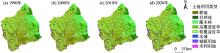
图4
1990—2020年马莲河下游流域土地利用类型"
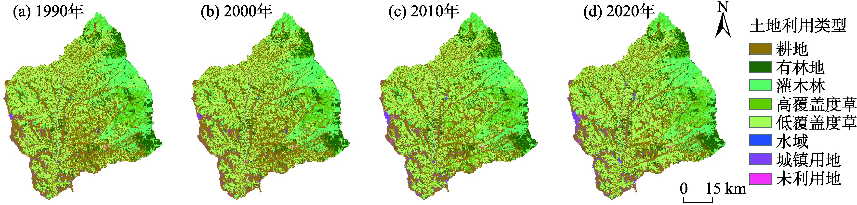
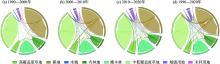
图5
马莲河下游流域土地利用转移"

表3
土地利用类型面积统计"
| 土地利用 类型 | 1990—2000年 | 2000—2010年 | 2010—2020年 | 1990—2020年 | |||||||
|---|---|---|---|---|---|---|---|---|---|---|---|
| 面积变化/km2 | 变化率/% | 面积变化/km2 | 变化率/% | 面积变化/km2 | 变化率/% | 面积变化/km2 | 变化率/% | ||||
| 耕地 | -10.39 | -0.53 | -226.47 | -11.65 | -32.5 | -1.89 | -269.36 | -13.79 | |||
| 有林地 | 1.07 | 0.23 | 17.14 | 3.72 | -0.39 | -0.08 | 17.82 | 3.88 | |||
| 灌木林 | 0.16 | 0.02 | 4.87 | 0.63 | 1.68 | 0.22 | 6.71 | 0.87 | |||
| 高覆盖度草地 | 0.12 | 0.04 | 137.95 | 51.27 | -85.56 | -21.02 | 52.51 | 19.52 | |||
| 低覆盖度草地 | -0.06 | 0.01 | 31.08 | 1.74 | 92.39 | 5.09 | 123.41 | 6.91 | |||
| 水域 | -0.89 | -7.21 | -0.9 | -7.86 | 0.12 | 1.14 | -1.67 | -13.53 | |||
| 城镇用地 | 9.16 | 9.02 | 33.93 | 30.64 | 19.29 | 13.33 | 62.38 | 61.41 | |||
| 未利用地 | 0.78 | 0.39 | 0.4 | 0.14 | 0.93 | 0.29 | 2.11 | 1.07 | |||
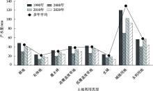
图6
1990—2020年马莲河下游流域各土地利用类型年平均产水量变化"

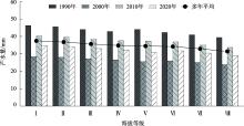
图7
1990—2020年马莲河下游流域不同海拔年平均产水量变化"

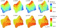
图8
马莲河下游流域降水量和实际蒸散发量空间分布格局"

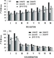
图9
1990—2020年马莲河下游流域不同降水量和实际蒸散发量等级的年平均产水量变化"

表4
1990—2020年马莲河下游流域各类因子对产水量空间分布的解释力"
| 年份 | 降水 | 实际蒸散发 | 海拔 | 土地利用类型 |
|---|---|---|---|---|
| 1990年 | 0.616 | 0.517 | 0.344 | 0.196 |
| 2000年 | 0.722 | 0.653 | 0.370 | 0.135 |
| 2010年 | 0.714 | 0.618 | 0.367 | 0.135 |
| 2020年 | 0.735 | 0.625 | 0.376 | 0.114 |
| [1] | Liu J, Li J, Qin K, et al. Changes in land-uses and ecosystem services under multi-scenarios simulation[J]. Science of the Total Environment, 2017, 586, 522-526. |
| [2] | Lang Y, Song W, Deng X. Projected land use changes impacts on water yields in the karst mountain areas of China[J]. Physics and Chemistry of the Earth, Parts A/B/C, 2018, 104: 66-75. |
| [3] |
戴尔阜, 王晓莉, 朱建佳, 等. 生态系统服务权衡/协同研究进展与趋势展望[J]. 地球科学进展, 2015, 30(11): 1250-1259.
doi: 10.11867/j.issn.1001-8166.2015.11.1250 |
|
[Dai Erfu, Wang Xiaoli, Zhu Jianjia, et al. Progress and perspective on ecosystem services trade-offs[J]. Advances in Earth Science, 2015, 30(11): 1250-1259.]
doi: 10.11867/j.issn.1001-8166.2015.11.1250 |
|
| [4] | Wang Y, Ye A, Peng D, et al. Spatiotemporal variations in water conservation function of the Tibetan Plateau under climate change based on InVEST model[J]. Journal of Hydrology: Regional Studies, 2022, 41: 101064. |
| [5] | Sun S, Sun G, Cohen E, et al. Projecting water yield and ecosystem productivity across the United States by linking an ecohydrological model to WRF dynamically downscaled climate data[J]. Hydrology and Earth System Sciences, 2016, 20(2): 935-952. |
| [6] | 孙琪, 徐长春, 任正良, 等. 塔里木河流域产水量时空分布及驱动因素分析[J]. 灌溉排水学报, 2021, 40(8): 114-122. |
| [Sun Qi, Xu Changchun, Ren Zhengliang, et al. Spatiotemporal variation in water yield and their underlying mechanisms in Tarim River Basin[J]. Journal of Irrigation and Drainage, 2021, 40(8): 114-122.] | |
| [7] | 吴健, 李英花, 黄利亚, 等. 东北地区产水量时空分布格局及其驱动因素[J]. 生态学杂志, 2017, 36(11): 3216-3223. |
| [Wu Jian, Li Yinghua, Huang Liya, et al. Spatiotemporal variation of water yield and its driving factors in Northeast China[J]. Chinese Journal of Ecology, 2017, 36(11): 3216-3223.] | |
| [8] | Nahib I, Ambarwulan W, Rahadiati A, et al. Assessment of the impacts of climate and LULC changes on the water yield in the Citarum River Basin, West Java Province, Indonesia[J]. Sustainability, 2021, 13(7): 3919. |
| [9] | Pérez-Cutillas P, Banos Paez P, Banos-González I. Variability of water balance under climate change scenarios. Implications for sustainability in the Rhône River Basin[J]. Sustainability, 2020, 12(16): 6402. |
| [10] | Wang X, Liu G, Lin D, et al. Water yield service influence by climate and land use change based on InVEST model in the monsoon hilly watershed in South China[J]. Geomatics, Natural Hazards and Risk, 2022, 13(1): 2024-2048. |
| [11] | 赵美亮, 曹广超, 赵青林, 等. 气候及土地利用变化对大通河源区水文要素空间分布的影响[J]. 干旱区研究, 2023, 40(3): 381-391. |
| [Zhao Meiliang, Cao Guangchao, Zhao Qinglin, et al. Effects of climate and land use change on the spatial distribution of hydrological factors in the source region of Datong River[J]. Arid Zone Research, 2023, 40(3): 381-391.] | |
| [12] | 刘斯文, 刘海隆, 王玲. MIKE SHE模型的发展与应用研究[J]. 水文, 2018, 38(5): 23-28. |
| [Liu Siwen, Liu Hailong, Wang Ling. Development and application of MIKE SHE model[J]. Journal of China Hydrology, 2018, 38(5): 23-28.] | |
| [13] | Zhou S, Wang Y, Guo A, et al. Impacts of changes in the watershed partitioning level and optimization algorithm on runoff simulation: Decomposition of uncertainties[J]. Stochastic Environmental Research and Risk Assessment, 2020, 34: 1909-1923. |
| [14] | 雷馨, 海新权. 祁连山地区土地利用变化对碳储量的影响及经济价值估算[J]. 干旱区研究, 2023, 40(11): 1845-1854. |
| [Lei Xin, Hai Xinquan. Impacts of land use change on carbon storage and estimation of economic value in Qilian Mountain region[J]. Arid Zone Research, 2023, 40(11): 1845-1854.] | |
| [15] | Redhead J W, Stratford C, Sharps K, et al. Empirical validation of the InVEST water yield ecosystem service model at a national scale[J]. Science of the Total Environment, 2016, 569: 1418-1426. |
| [16] | Belete M, Deng J, Wang K, et al. Evaluation of satellite rainfall products for modeling water yield over the source region of Blue Nile Basin[J]. Science of the Total Environment, 2020, 708: 134834. |
| [17] | Wang Y, Wang H, Zhang J, et al. Exploring interactions in water-related ecosystem services nexus in Loess Plateau[J]. Journal of Environmental Management, 2023, 336: 117550. |
| [18] |
包玉斌, 李婷, 柳辉, 等. 基于InVEST模型的陕北黄土高原水源涵养功能时空变化[J]. 地理研究, 2016, 35(4): 664-676.
doi: 10.11821/dlyj201604006 |
|
[Bao Yubin, Li Ting, Liu Hui, et al. Spatial and temporal changes of water conservation of Loess Plateau in northern Shaanxi Province by InVEST model[J]. Geographical Research, 2016, 35(4): 664-676.]
doi: 10.11821/dlyj201604006 |
|
| [19] | 刘宥延, 刘兴元, 张博, 等. 基于InVEST模型的黄土高原丘陵区水源涵养功能空间特征分析[J]. 生态学报, 2020, 40(17): 6161-6170. |
| [Liu Youyan, Liu Xingyuan, Zhang Bo, et al. Spatial features analysis of water conservation function in the hilly areas of the Loess Plateau based on InVEST model[J]. Acta Ecologica Sinica, 2020, 40(17): 6161-6170.] | |
| [20] | 王雨山, 程旭学, 张梦南. 马莲河流域河水化学特征和化学风化过程分析[J]. 地球与环境, 2018, 46(1): 15-22. |
| [Wang Yushan, Cheng Xuxue, Zhang Mengnan. Hydrochemistry and chemical weathering processes of Malian River Basin[J]. Earth and Environment, 2018, 46(1): 15-22.] | |
| [21] | 彭世想, 郭相秦, 刘卓, 等. 马莲河流域水沙变化与水土保持成效分析[J]. 中国水土保持, 2020 (11): 29-31, 48. |
| [Peng Shixiang, Guo Xiangqin, Liu Zuo, et al. Analysis on water and sediment change and soil and water conservation effect in Malian River Watershed[J]. Soil and Water Conservation in China, 2020(11): 29-31, 48.] | |
| [22] | 龚诗涵, 肖洋, 郑华, 等. 中国生态系统水源涵养空间特征及其影响因素[J]. 生态学报, 2017, 37(7): 2455-2462. |
| [Gong Shihan, Xiao Yang, Zheng Hua, et al. Spatial patterns of ecosystem water conservation in China and its impact factors analysis[J]. Acta Ecologica Sinica, 2017, 37(7): 2455-2462.] | |
| [23] | Hu W, Li G, Li Z. Spatial and temporal evolution characteristics of the water conservation function and its driving factors in regional lake wetlands—Two types of homogeneous lakes as examples[J]. Ecological Indicators, 2021, 130: 108069. |
| [24] | Yan F, Shangguan W, Zhang J, et al. Depth-to-bedrock map of China at a spatial resolution of 100 meters[J]. Scientific Data, 2020, 7(1): 2. |
| [25] | 周文佐. 基于GIS的我国主要土壤类型土壤有效含水量研究[D]. 南京: 南京农业大学, 2003. |
| [Zhou Wenzuo. A Study on Available Water Capacity of Main Soil Types in China Based on Geographic Information System[D]. Nanjing: Nanjing Agricultural University, 2003.] | |
| [26] |
王劲峰, 徐成东. 地理探测器: 原理与展望[J]. 地理学报, 2017, 72(1): 116-134.
doi: 10.11821/dlxb201701010 |
|
[Wang Jinfeng, Xu Chengdong. Geodetector: Principle and prospective[J]. Acta Geographica Sinica, 2017, 72(1): 116-134.]
doi: 10.11821/dlxb201701010 |
|
| [27] | Moriasi D N, Gitau M W, Pai N, et al. Hydrologic and water quality models: Performance measures and evaluation criteria[J]. Transactions of the ASABE, 2015, 58(6): 1763-1785. |
| [28] | 郑续, 魏乐民, 郭建军, 等. 基于地理探测器的干旱区内陆河流域产水量驱动力分析——以疏勒河流域为例[J]. 干旱区地理, 2020, 43(6): 1477-1485. |
| [Zheng Xu, Wei Lemin, Guo Jianjun, et al. Driving force analysis of water yield in inland river basins of arid areas based on geo-detectors: A case of the Shule River[J]. Arid Land Geography, 2020, 43(6): 1477-1485.] | |
| [29] | 郭倩. 全球气候变化背景下土地利用和流域水生态系统响应研究[D]. 兰州: 兰州大学, 2022. |
| [Guo Qian. The Responses of Land Use and Watershed Water-related Ecosystem under Global Climate Change[D]. Lanzhou: Lanzhou University, 2022.] | |
| [30] |
杨洁, 谢保鹏, 张德罡. 基于InVEST模型的黄河流域产水量时空变化及其对降水和土地利用变化的响应[J]. 应用生态学报, 2020, 31(8): 2731-2739.
doi: 10.13287/j.1001-9332.202008.015 |
|
[Yang Jie, Xie Baopeng, Zhang Degang. Spatio-temporal variation of water yield and its response to precipitation and land use change in the Yellow River Basin based on InVEST model[J]. Chinese Journal of Applied Ecology, 2020, 31(8): 2731-2739.]
doi: 10.13287/j.1001-9332.202008.015 |
|
| [31] | 赖明, 陈仁升, 刘玖芬, 等. 雅鲁藏布江下游产水量时空演变及对气候和土地利用变化的响应[J]. 草业科学, 2022, 39(12): 2516-2526. |
| [Lai Ming, Chen Rensheng, Liu Jiufen, et al. Temporal and spatial evolution of water yield in the lower reaches of the Yarlung Zangbo River and its response to climate and land use change[J]. Pratacultural Science, 2022, 39(12): 2516-2526.] | |
| [32] |
刘美娟, 仲俊涛, 王蓓, 等. 基于InVEST模型的青海湖流域产水功能时空变化及驱动因素分析[J]. 地理科学, 2023, 43(3): 411-422.
doi: 10.13249/j.cnki.sgs.2023.03.004 |
|
[Liu Meijuan, Zhong Juntao, Wang Bei, et al. Spatiotemporal change and driving factor analysis of the Qinghai Lake Basin based on InVEST model[J]. Scientia Geographica Sinica, 2023, 43(3): 411-422.]
doi: 10.13249/j.cnki.sgs.2023.03.004 |
|
| [33] | 董玉婷, 穆兴民, 王双银, 等. 产流及其研究进展[J]. 华北水利水电大学学报(自然科学版), 2022, 43(2): 21-29. |
| [Dong Yuting, Mu Xingmin, Wang Shuangyin, et al. Runoft ceneration and its research progress[J]. Journal of North China University of Water Resources and Electric Power (Natural Science Edition), 2022, 43(2): 21-29.] |
| [1] | 蔡玉琴, 祁栋林, 王烈福, 李海凤, 张德琴. 青海省不同等级寒冷日数时空演变特征[J]. 干旱区研究, 2024, 41(5): 742-752. |
| [2] | 李文秀, 燕振刚. 基于地理探测器的甘肃农牧交错带土地利用时空演化及其驱动机制[J]. 干旱区研究, 2024, 41(4): 590-602. |
| [3] | 刘如龙, 赵媛媛, 陈国清, 迟文峰, 刘正佳. 内蒙古黄河流域1990—2020年生境质量评估[J]. 干旱区研究, 2024, 41(4): 674-683. |
| [4] | 陶际峰, 包玉龙, 郭恩亮, 金额尔德木吐, 呼斯乐, 包玉海. 近40 a内蒙古冬旱时空演变特征[J]. 干旱区研究, 2024, 41(3): 387-398. |
| [5] | 李佳珂, 邵战林. 基于PLUS和InVEST模型的乌鲁木齐市碳储量时空演变与预测[J]. 干旱区研究, 2024, 41(3): 499-508. |
| [6] | 严莉, 曹广超, 康利刚, 刘梦琳, 叶得力. 基于InVEST模型的共和县生境质量时空变化及驱动因素[J]. 干旱区研究, 2024, 41(2): 314-325. |
| [7] | 申草,任宗萍,李鹏,王凯博,鲁克新,任正龑,魏小燕. 宁夏水土保持生态补偿优先区识别[J]. 干旱区研究, 2023, 40(9): 1527-1536. |
| [8] | 张晓敏, 张东梅, 张伟. 人类活动对额尔齐斯河流域碳储量的影响[J]. 干旱区研究, 2023, 40(8): 1333-1345. |
| [9] | 包玉斌,王耀宗,路锋,刘自增,马大为,杨勇,吴娟,张永康. 六盘山区国土空间生态安全格局构建与分区优化[J]. 干旱区研究, 2023, 40(7): 1172-1183. |
| [10] | 邹易, 蒙吉军. 干旱区绿洲-城镇-荒漠景观演变及生态环境效应[J]. 干旱区研究, 2023, 40(6): 988-1001. |
| [11] | 吴玥葶, 郭利丹, 井沛然, 黄峰, 王浩轩. 中亚五国水-能源-粮食-生态耦合关系及时空分异[J]. 干旱区研究, 2023, 40(4): 573-582. |
| [12] | 王鹏, 秦思彤, 胡慧蓉. 近30 a拉萨河流域土地利用变化和生境质量的时空演变特征[J]. 干旱区研究, 2023, 40(3): 492-503. |
| [13] | 陈实, 黄银兰, 金云翔. 退耕还林(草)工程实施前后黄河中游生境质量时空变化分析[J]. 干旱区研究, 2023, 40(3): 456-468. |
| [14] | 黄莹, 王素艳, 马阳, 王岱, 张雯, 王璠. 宁夏近60 a寒潮变化特征及其环流异常[J]. 干旱区研究, 2023, 40(11): 1718-1728. |
| [15] | 雷馨, 海新权. 祁连山地区土地利用变化对碳储量的影响及经济价值估算[J]. 干旱区研究, 2023, 40(11): 1845-1854. |
|
||