干旱区研究 ›› 2022, Vol. 39 ›› Issue (6): 1819-1831.doi: 10.13866/j.azr.2022.06.12
赵蒙恩1,2( ),闫庆武1,3(),刘政婷1,2,王文铭1,2,李桂娥1,3,吴振华1,3
收稿日期:2022-05-04
修回日期:2022-08-24
出版日期:2022-11-15
发布日期:2023-01-17
通讯作者:
闫庆武
作者简介:赵蒙恩(1997-),女,硕士研究生,主要研究方向为自然地理环境演变. E-mail: 基金资助:
ZHAO Mengen1,2(),YAN Qingwu1,3(),LIU Zhengting1,2,WANG Wenming1,2,LI Gui’e1,3,WU Zhenhua1,3
Received:2022-05-04
Revised:2022-08-24
Online:2022-11-15
Published:2023-01-17
Contact:
Qingwu YAN
摘要:
精确评估鄂尔多斯市土壤侵蚀时空变化并研究其影响因子,为该区域生态环境治理与矿区的水土保持提供参考。本文运用RUSLE模型和地理探测器方法,研究2000—2019年鄂尔多斯市土壤水力侵蚀状况,并分析其影响因子。结果表明:(1) 鄂尔多斯市2000年,2005年,2010年,2015年以及2019年的平均土壤侵蚀量分别为3865.49 t·km-2·a-1,2932.85 t·km-2·a-1,2890.21 t·km-2·a-1,3711.10 t·km-2·a-1,4308.21 t·km-2·a-1,在研究的20 a间平均土壤侵蚀量先减后增,采矿活动的增加是土壤侵蚀加重的主要原因。(2) 煤矿区20 km缓冲区内的土壤侵蚀情况向好的方向发展,矿区的生态治理措施有效且可行。(3) 坡度对鄂尔多斯市土壤侵蚀的解释力最强,被认定为主导因子,因子间的协同作用对土壤侵蚀的解释力有所增强。鄂尔多斯市土壤侵蚀情况以微度和轻度侵蚀为主,>35°坡度区间、0~0.3植被覆盖度区间和工矿用地是易发生土壤侵蚀的区域。因此,适当增加植被覆盖可以有效地防治水土流失。
赵蒙恩,闫庆武,刘政婷,王文铭,李桂娥,吴振华. 鄂尔多斯市土壤侵蚀时空演变及影响因子分析[J]. 干旱区研究, 2022, 39(6): 1819-1831.
ZHAO Mengen,YAN Qingwu,LIU Zhengting,WANG Wenming,LI Gui’e,WU Zhenhua. Analysis of temporal and spatial evolution and influencing factors of soil erosion in Ordos City[J]. Arid Zone Research, 2022, 39(6): 1819-1831.
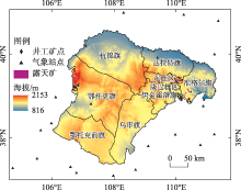
图1
研究区概况 注:底图采用内蒙古自治区自然资源厅标准地图制作,审图号为蒙S(2017)029号,对底图边界无修改。下同。"

表1
数据来源及参数"
| 数据类型 | 数据获取及处理 |
|---|---|
| Landsat数据 | 解译分类后的数据精度kappa≥0.8 土地利用类型包括:耕地、水域、植被(主要为草地)、城镇用地、工矿用地及其他用地 |
| MODIS数据 | 植物生长季(6—9月)MOD13Q1数据计算植被覆盖度 |
| 气象数据 | 2000—2019年54个气象站点的日降水数据,插值方法为普通克里金 |
| DEM数据 | 分辨率为30 m,提取坡度、坡向 |
| 土壤数据 | 砂粒、粉粒和黏粒(以百分比显示) |
表2
土地利用类型P值"
| 土地利用类型 | 水系 | 草地 | 城镇用地 | 工矿用地 | 其他用地 |
|---|---|---|---|---|---|
| P值 | 0.0 | 0.8 | 0.1 | 1.0 | 1.0 |
表3
坡耕地坡度与P值换算关系"
| 坡度/% | 1~2 | 3~5 | 6~8 | 9~12 | 13~16 | 17~20 | >20 |
|---|---|---|---|---|---|---|---|
| P值 | 0.4 | 0.5 | 0.5 | 0.6 | 0.7 | 0.8 | 1.0 |
表4
双影响因子的交互作用"
| 判据 | 交互作用 |
|---|---|
| q(X1∩X2)<Min[q(X1),q(X2)] | 非线性减弱 |
| Min[q(X1),q(X2)]<q(X1∩X2)<Max[q(X1),q(X2)] | 单因子非线性减弱 |
| q(X1∩X2)>Max[q(X1),q(X2)] | 双因子增强 |
| q(X1∩X2)=q(X1)+q(X2) | 独立 |
| q(X1∩X2)>q(X1)+q(X2) | 非线性增强 |

图2
2000—2019年鄂尔多斯市土壤侵蚀等级分布"
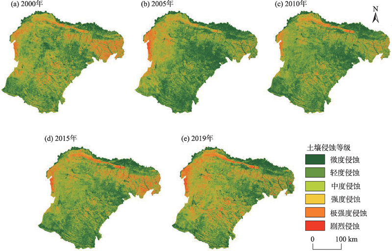
表5
不同土壤侵蚀等级面积"
| 侵蚀等级 | 面积/km2 | 比例/% | |||||||||
|---|---|---|---|---|---|---|---|---|---|---|---|
| 2000年 | 2005年 | 2010年 | 2015年 | 2019年 | 2000年 | 2005年 | 2010年 | 2015年 | 2019年 | ||
| 微度 | 22839.56 | 33191.72 | 29709.93 | 24713.01 | 22828.82 | 26.26 | 38.16 | 34.16 | 28.41 | 26.25 | |
| 轻度 | 25270.39 | 24532.83 | 27151.54 | 25847.95 | 22378.47 | 29.06 | 28.21 | 31.22 | 29.72 | 25.73 | |
| 中度 | 19073.19 | 15530.29 | 16791.69 | 18171.16 | 19312.13 | 21.93 | 17.86 | 19.31 | 20.89 | 22.20 | |
| 强度 | 9276.38 | 6907.29 | 6985.41 | 8558.72 | 10216.18 | 10.67 | 7.94 | 8.03 | 9.84 | 11.75 | |
| 极强度 | 7031.62 | 4744.24 | 4537.77 | 6309.29 | 8072.58 | 8.08 | 5.45 | 5.22 | 7.25 | 9.28 | |
| 剧烈 | 3482.65 | 2067.40 | 1797.13 | 3373.29 | 4165.18 | 4.00 | 2.38 | 2.07 | 3.88 | 4.79 | |
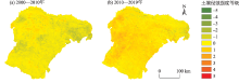
图3
鄂尔多斯市各时段土壤侵蚀强度等级变化 注:负数代表土壤侵蚀强度等级下降,正数代表土壤侵蚀强度等级升高,绝对值越大代表侵蚀强度等级变化越大。"


图4
鄂尔多斯市土地利用类型空间分布"

表6
土地利用类型面积"
| 2000年 | 2005年 | 2010年 | 2015年 | 2019年 | |
|---|---|---|---|---|---|
| 耕地 | 3.87 | 3.94 | 4.04 | 5.12 | 5.12 |
| 水域 | 1.24 | 1.48 | 1.34 | 1.24 | 1.52 |
| 工矿用地 | 0.04 | 0.15 | 0.55 | 0.95 | 0.84 |
| 城镇用地 | 0.26 | 0.44 | 0.56 | 0.61 | 0.65 |
| 草地 | 65.45 | 64.14 | 66.30 | 65.84 | 65.68 |
| 其他用地 | 29.14 | 29.85 | 27.22 | 26.24 | 26.20 |
表7
各土地利用类型的平均土壤侵蚀量"
| 2000年 | 2005年 | 2010年 | 2015年 | 2019年 | |
|---|---|---|---|---|---|
| 耕地 | 924.72 | 474.56 | 616.79 | 803.35 | 501.95 |
| 工矿用地 | 6549.87 | 5838.23 | 7000.92 | 8977.01 | 14450.75 |
| 城镇用地 | 272.35 | 161.57 | 264.02 | 324.55 | 302.48 |
| 草地 | 3505.69 | 2824.72 | 2437.27 | 3443.18 | 3775.18 |
| 其他用地 | 5244.54 | 3655.50 | 5615.15 | 5001.56 | 6397.47 |
图5
鄂尔多斯市坡度分带"


图6
鄂尔多斯市各坡度带平均土壤侵蚀量"
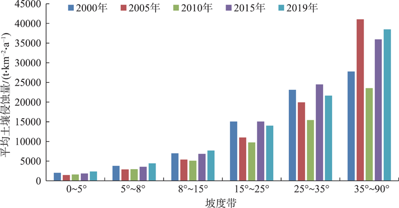
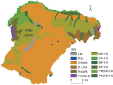
图7
鄂尔多斯市地貌类型"

表8
各地貌类型的平均土壤侵蚀量"
| 2000年 | 2005年 | 2010年 | 2015年 | 2019年 | |
|---|---|---|---|---|---|
| 中起伏山地 | 10714.33 | 15044.19 | 8821.27 | 13159.85 | 15159.90 |
| 剥蚀台地 | 4851.99 | 7887.17 | 4077.70 | 5603.21 | 7884.93 |
| 干燥洪积平原 | 5619.93 | 6823.66 | 4345.24 | 5421.02 | 7475.73 |
| 黄土梁峁 | 7477.71 | 3216.24 | 3589.22 | 7035.75 | 4663.14 |
| 剥蚀平原 | 4430.40 | 3474.53 | 2971.53 | 4530.06 | 4608.90 |
| 丘陵 | 4155.03 | 3160.80 | 2994.71 | 4474.03 | 4462.66 |
| 冲积洪积平原 | 4763.53 | 2782.47 | 3183.56 | 4875.86 | 4004.45 |
| 湖积平原 | 2777.36 | 1903.60 | 2823.42 | 3156.54 | 3939.80 |
| 风积地貌 | 3219.93 | 2079.13 | 2637.73 | 2849.38 | 3773.89 |
| 冲积平原 | 1966.72 | 2089.69 | 1735.16 | 1904.83 | 2418.63 |
| 洪积平原 | 1831.32 | 2283.16 | 1593.97 | 1925.75 | 2354.03 |
表9
影响因子解释力"
| 影响因子 | 土地利用类型 | 植被覆盖度 | 年均降水量 | 坡度 | 距矿区距离 |
|---|---|---|---|---|---|
| q值 | 0.0753 | 0.1145 | 0.0338 | 0.2131 | 0.0119 |
表10
双因子交互作用下的解释力"
| 影响因子 | 土地利用类型 | 植被覆盖度 | 降水 | 坡度 | 距矿区距离 |
|---|---|---|---|---|---|
| 土地利用类型 | 0.0753 | 0.1725 | 0.1129 | 0.3830 | 0.1124 |
| 植被覆盖度 | 0.1725 | 0.1145 | 0.1383 | 0.4019 | 0.1436 |
| 降水 | 0.1129 | 0.1383 | 0.0338 | 0.2825 | 0.0795 |
| 坡度 | 0.3830 | 0.4019 | 0.2825 | 0.2131 | 0.2532 |
| 距矿区距离 | 0.1124 | 0.1436 | 0.0795 | 0.2532 | 0.0119 |
表11
土壤侵蚀高风险区域及平均侵蚀量"
| 影响因子 | 降水/mm | 坡度 | 植被覆盖度 | 土地利用类型 | 距离/m |
|---|---|---|---|---|---|
| 高风险区 | 141.02~174.62 | >35° | <0.3 | 工矿用地 | 0~13528 |
| 平均侵蚀量/(t·km-2·a-1) | 7882.84 | 40530.58 | 6496.18 | 14450.75 | 5865.62 |
| [1] | 颜世敏, 马阔. 土壤侵蚀影响因素及其危害分析[J]. 江西农业, 2019(6): 67. |
| [ Yan Shimin, Ma Kuo. Analysis on influencing factors and hazards of soil erosion[J]. Jiangxi Agriculture, 2019(6): 67. ] | |
| [2] | 陈朝良, 赵广举, 穆兴民, 等. 基于RUSLE模型的湟水流域土壤侵蚀时空变化[J]. 水土保持学报, 2021, 35(4): 73-79. |
| [ Chen Chaoliang, Zhao Guangju, Mu Xingmin, et al. Spatial-temporal change of soil erosion in Huangshui Watershed based on RUSLE model[J]. Journal of Soil and Water Conservation, 2021, 35(4): 73-79. ] | |
| [3] | 张素, 熊东红, 吴汉, 等. 基于RUSLE模型的孙水河流域土壤侵蚀空间分异特征[J]. 水土保持学报, 2021, 35(5): 24-30. |
| [ Zhang Su, Xiong Donghong, Wu Han, et al. Research on spatial variation of soil erosion in Sunshui River Basin based on RUSLE model[J]. Journal of Soil and Water Conservation, 2021, 35(5): 24-30. ] | |
| [4] |
Islam M R, Wan Z, Lai S H, et al. Development of an erosion model for Langat River Basin, Malaysia, adapting GIS and RS in RUSLE[J]. Applied Water Science, 2020, 10(7): 1-11.
doi: 10.1007/s13201-019-1058-x |
| [5] | Melese T, Senamaw A, Belay T, et al. The spatiotemporal dynamics of land use land cover change, and its impact on soil erosion in Tagaw Watershed, Blue Nile Basin, Ethiopia[J]. Global Challenges, 2021, 5(7): 1-13. |
| [6] |
Alitane A, Essahlaoui A, Hafyani M E, et al. Water erosion monitoring and prediction in response to the effects of climate change using RUSLE and SWAT equations: Case of R’Dom Watershed in Morocco[J]. Land, 2022, 11(1): 93.
doi: 10.3390/land11010093 |
| [7] | 贾磊, 姚顺波, 邓元杰, 等. 渭河流域土壤侵蚀时空特征及其地理探测[J]. 生态与农村环境学报, 2021, 37(3): 305-314. |
| [ Ja Lei, Yao Shunbo, Deng Yuanjie, et al. Temporal and spatial characteristics of soil erosion risk in Weihe River Basin and its geographical exploration[J]. Journal of Ecology and Rural Environment, 2021, 37(3): 305-314. ] | |
| [8] | 田义超, 黄远林, 张强, 等. 北部湾钦江流域土壤侵蚀及其硒元素流失评估[J]. 中国环境科学, 2019, 39(1): 257-273. |
| [ Tian Yichao, Huang Yuanlin, Zhang Qiang, et al. Soil erosion and selenium loss in Qinjiang River Basin in Beibu Gulf coastal zone[J]. China Environmental Science, 2019, 39(1): 257-273. ] | |
| [9] |
Mhaske S N, Pathak K, Dash S S, et al. Assessment and management of soil erosion in the hilltop mining dominated catchment using GIS integrated RUSLE model[J]. Journal of Environmental Management, 2021, 294(11): 112987.
doi: 10.1016/j.jenvman.2021.112987 |
| [10] | 王慧子. 经济新常态下煤炭经济的发展问题及对策——以内蒙古为例[J]. 内蒙古科技与经济, 2020(18): 51-52. |
| [ Wang Huizi. Development problems and countermeasures of coal economy under the new normal of economy: Taking Inner Mongolia as an example[J]. Inner Mongolia Science Technology & Economy, 2020(18): 51-52. ] | |
| [11] | 白壮壮, 崔建新, 丁晓辉. 1986—2015年鄂尔多斯高原沙漠化及其驱动因素研究[J]. 干旱区研究, 2020, 37(3): 749-756. |
| [ Bai Zhuangzhuang, Cui Jianxin, Ding Xiaohui. Desertification and its driving factors in the Ordos Plateau, from 1986 to 2015[J]. Arid Zone Research, 2020, 37(3): 749-756. ] | |
| [12] | 陈佳锐, 叶子瑜, 张照熙, 等. 基于超效率BCC-DEA模型西部城市产业园国土空间利用绩效评价——以鄂尔多斯市为例[J]. 上海国土资源, 2021, 42(2): 44-48, 94. |
| [ Chen Jiarui, Ye Ziyu, Zhang Zhaoxi, et al. Performance evaluation of land and space utilization of industrial parks in western cities based on the super efficiency BCC-DEA model: A case study of Ordos City[J]. Shanghai Land & Resources, 2021, 42(2): 44-48, 94. ] | |
| [13] | 陶鸿斌, 汪文飞. 基于GIS分析土壤侵蚀过程中氮磷流失分布——以定西市安定区为例[J]. 绿色科技, 2018(24): 15-17, 19. |
| [ Tao Hongbin, Wang Wenfei. Analysis of nitrogen and phosphorus losses in soil erosion process based on GIS: Taking Dingxi city Anding district as an example[J]. Journal of Green Science and Technology, 2018(24): 15-17, 19. ] | |
| [14] | 章文波, 付金生. 不同类型雨量资料估算降水侵蚀力[J]. 资源科学, 2003, 25(1): 35-41. |
| [ Zhang Wenbo, Fu Jinsheng. Rainfall erosivity estimation under different rainfall amount[J]. Resources Science, 2003, 25(1): 35-41. ] | |
| [15] |
胡刚, 宋慧, 石星军, 等. 基于RUSLE的卧虎山水库流域土壤侵蚀特征分析[J]. 地理科学, 2018, 38(4): 610-617.
doi: 10.13249/j.cnki.sgs.2018.04.015 |
|
[ Hu Gang, Song Hui, Shi Xingjun, et al. Soil erosion characteristics based on RUSLE in the Wohushan Reservoir Watershed[J]. Scientia Geographica Sinica, 2018, 38(4): 610-617. ]
doi: 10.13249/j.cnki.sgs.2018.04.015 |
|
| [16] | Williams J R, Renard K G, Dyke P T. EPIC: A new method for assessing erosion’s effect on soil productivity[J]. Journal of Soil & Water Conservation, 1983, 38(5): 381-383. |
| [17] | Foster G R, Mccool D K, Renard K G, et al. Conversion of the universal soil los equation to SI metric units[J]. Journal of Soil and Water Conservation, 1981, 36(6): 355-359. |
| [18] | 张园眼, 李天宏. 基于GIS和RUSLE模型的深圳市土壤侵蚀研究[J]. 应用基础与工程科学学报, 2018, 26(6): 1189-1202. |
| [ Zhang Yuanyan, Li Tianhong. Soil erosion in Shenzhen city based on GIS and RUSLE model[J]. Journal of Basic Science and Engineering, 2018, 26(6): 1189-1202. ] | |
| [19] | Renard K G, Foster G R, Weesies G A, et al. Predicting Soil Erosion by Water: A Guide to Conservation Planning with the Revised Universal Soil Loss Equation (RUSLE)[M]. Washington DC: United States Department of Agriculture, 1997: 143-182. |
| [20] |
Mccool D K, Brown L C, Foster G R, et al. Revised slope steepness factor for the universal soil loss equation[J]. Transactions of the ASAE, 1987, 30(5): 1387-1396.
doi: 10.13031/2013.30576 |
| [21] |
Liu B Y, Nearing M A, Risse L M. Slope gradient effects on soil loss for steep slopes[J]. Transactions of the ASAE, 1994, 37(6): 1835-1840.
doi: 10.13031/2013.28273 |
| [22] | 陈童尧, 贾燕锋, 王佳楠, 等. 基于InVEST模型的祁连山国家级自然保护区土壤保持现状与功能[J]. 干旱区研究, 2020, 37(1): 150-159. |
| [ Chen Tongyao, Jia Yanfeng, Wang Jianan, et al. Current situation and function of soil conservation in national nature reserves in the Qilian Mountains based on InVEST model[J]. Arid Zone Research, 2020, 37(1): 150-159. ] | |
| [23] | 蔡崇法, 丁树文, 史志华, 等. 应用USLE模型与地理信息系统IDRISI预测小流域土壤侵蚀量的研究[J]. 水土保持学报, 2000, 14(2): 19-24. |
| [ Cai Chongfa, Ding Shuwen, Shi Zhihua, et al. Study of applying USLE and geographical information system IDRISI to predict soil erosion in small watershed[J]. Joumal of Soil and Water Conservation, 2000, 14(2): 19-24. ] | |
| [24] | 尹璐. 扎赉诺尔矿区土地利用格局及其土地退化演变分析[D]. 徐州: 中国矿业大学, 2016. |
| [ Yin Lu. The Analysis of Land Use and Degradation Changes in Zhalainur Mining Area[D]. Xuzhou: China University of Mining and Technology, 2016. ] | |
| [25] | 周平, 蒙吉军. 鄂尔多斯市1988—2000年土壤水力侵蚀与土地利用时空变化关系[J]. 自然资源学报, 2009, 24(10): 1706-1717. |
| [ Zhou Ping, Meng Jijun. The temporal and spatial variability relationship of soil water erosion and land use type in Ordos during the period of 1988-2000[J]. Journal of Natural Resources, 2009, 24(10): 1706-1717. ] | |
| [26] |
黄婷, 于德永, 乔建民, 等. 内蒙古锡林郭勒盟景观格局变化对土壤保持能力的影响[J]. 资源科学, 2018, 40(6): 1256-1266.
doi: 10.18402/resci.2018.06.15 |
|
[ Huang Ting, Yu Deyong, Qiao Jianmin, et al. Landscape pattern change and soil conservation in Xilingol League, Inner Mongolia[J]. Resources Science, 2018, 40(6): 1256-1266. ]
doi: 10.18402/resci.2018.06.15 |
|
| [27] |
王劲峰, 徐成东. 地理探测器: 原理与展望[J]. 地理学报, 2017, 72(1): 116-134.
doi: 10.11821/dlxb201701010 |
|
[ Wang Jinfeng, Xu Chengdong. Geodetector: Principle and prospective[J]. Acta Geographica Sinica, 2017, 72(1): 116-134. ]
doi: 10.11821/dlxb201701010 |
|
| [28] | 邹雅婧, 闫庆武, 谭学玲, 等. 渭北矿区土壤侵蚀评估及驱动因素分析[J]. 干旱区地理, 2019, 42(6): 1387-1394. |
| [ Zou Yajing, Yan Qingwu, Tan Xueling, et al. Evaluation of soil erosion and driving factors analysis in Weibei mining area[J]. Arid Land Geography, 2019, 42(6): 1387-1394. ] | |
| [29] | 中华人民共和国水利部. 土壤侵蚀分类分级标准(SL190-2007)[S]. 北京: 中国水利水电出版社, 2008. |
| [ Ministry of Water Resources of the People’s Republic of China. Standards for Classification and Gradation of Soil Erosion (SL190-2007)[S]. Beijing: China Water & Power Press, 2008. ] | |
| [30] | 刘英, 魏嘉莉, 岳辉, 等. 神东矿区土壤侵蚀时空特征及驱动力分析[J]. 测绘科学, 2022, 47(1): 142-153. |
| [ Liu Ying, Wei Jiali, Yue Hui, et al. Analysis on temporal and spatial characteristics and driving factors of soil erosion in Shendong mining area[J]. Science of Surveying and Mapping, 2022, 47(1): 142-153. ] | |
| [31] | 张珊珊, 周忠发, 孙小涛, 等. 基于坡度等级的喀斯特山区石漠化与水土流失相关性研究——以贵州省盘县为例[J]. 水土保持学报, 2017, 31(2): 79-86. |
| [ Zhang Shanshan, Zhou Zhongfa, Sun Xiaotao, et al. Based on the slope grade of rocky desertification and water and soil loss correlation study in Karst Mountain Area: A case in Panxian county, Guizhou[J]. Journal of Soil and Water Conservation, 2017, 31(2): 79-86. ] |
| [1] | 齐润泽, 潘竟虎. 河湟地区生态脆弱性时空演变及影响因素研究[J]. 干旱区研究, 2023, 40(6): 1002-1013. |
| [2] | 刘笑, 郭鹏, 祁佳峰, 杜文玲, 张茹倩, 张坤. 基于MRSEI模型的阿勒泰市生态环境时空变化及驱动力分析[J]. 干旱区研究, 2023, 40(6): 1014-1026. |
| [3] | 崔洋,王岱,高睿娜,安兴琴. 宁夏近60 a大气环境容量变化特征及其影响因子[J]. 干旱区研究, 2023, 40(6): 885-895. |
| [4] | 姚春艳, 刘洪鹄, 刘竞. 长江源区1980—2020年水沙变化规律[J]. 干旱区研究, 2023, 40(5): 726-736. |
| [5] | 吕锦心, 梁康, 刘昌明, 张仪辉, 刘璐. 无定河流域土地覆被空间分异机制及相关水碳变量变化[J]. 干旱区研究, 2023, 40(4): 563-572. |
| [6] | 李鑫磊, 李瑞平, 王秀青, 王思楠, 王成坤. 基于地理探测器的河套灌区林草植被覆盖度时空变化与驱动力分析[J]. 干旱区研究, 2023, 40(4): 623-635. |
| [7] | 马浩文, 王永芳, 郭恩亮. 基于GEE的翁牛特旗土地沙漠化遥感监测[J]. 干旱区研究, 2023, 40(3): 504-516. |
| [8] | 李素雲,祁栋林,温婷婷,史飞飞,乔斌,肖建设. 1961—2020年青海省饱和水汽压差变化特征及影响因子分析[J]. 干旱区研究, 2023, 40(2): 173-181. |
| [9] | 徐涛,于欢,孔博,邱霞,胡孟珂,凌鹏飞. 藏北高原砾石粒径空间异质性研究[J]. 干旱区研究, 2023, 40(2): 292-302. |
| [10] | 贺军奇,拜寒伟,徐轶玮,倪莉莉. 陕西黄土区农田土壤主要养分特征及影响因素[J]. 干旱区研究, 2023, 40(12): 1907-1917. |
| [11] | 侯文兵, 李开明, 黄卓. 近20 a河西地区绿洲效应时空变化特征及归因分析[J]. 干旱区研究, 2023, 40(12): 2031-2042. |
| [12] | 郑欣如, 王树森, 王博, 张欣, 刘静, 胡晶华, 李诗文, 袁亚楠, 王丫博. 采煤沉陷区模拟土壤侵蚀胁迫对黑沙蒿生理生长特性的影响[J]. 干旱区研究, 2023, 40(11): 1806-1814. |
| [13] | 吴雪晴, 张乐乐, 高黎明, 李炎坤, 刘轩辰. 青海湖流域NPP动态变化及驱动力[J]. 干旱区研究, 2023, 40(11): 1824-1832. |
| [14] | 裴宏泽, 赵亚超, 张廷龙. 2000—2020年黄土高原NEP时空格局与驱动力[J]. 干旱区研究, 2023, 40(11): 1833-1844. |
| [15] | 王琦琨,武玮,杨雪琪,桑国庆. 陕西省生境质量时空演变及驱动机制分析[J]. 干旱区研究, 2022, 39(5): 1684-1694. |
|
||