干旱区研究 ›› 2023, Vol. 40 ›› Issue (5): 726-736.doi: 10.13866/j.azr.2023.05.05
姚春艳1,2,3( ),刘洪鹄1,2,4(),刘竞1,2,3
收稿日期:2022-08-18
修回日期:2022-10-06
出版日期:2023-05-15
发布日期:2023-05-30
通讯作者:
刘洪鹄. E-mail: liuhh@mail.crsri.cn
作者简介:姚春艳(1998-),女,硕士研究生,主要从事土壤侵蚀与水土保持研究. E-mail: 基金资助:
YAO Chunyan1,2,3(),LIU Honghu1,2,4(),LIU Jing1,2,3
Received:2022-08-18
Revised:2022-10-06
Online:2023-05-15
Published:2023-05-30
摘要:
基于长江源区1980—2020年12个站点日降水及直门达站年径流及泥沙等数据,利用中国土壤流失方程、偏最小二乘结构方程和累积距平等方法,分析源区土壤侵蚀、河道水沙变化及长时间尺度下与降水的耦合作用机制。结果表明:(1) 长江源区年土壤侵蚀模数呈显著增加趋势(P<0.05),且年均土壤侵蚀模数为4.71 t·hm-2·a-1,强烈及以上强度侵蚀主要分布在源区东南部。(2) 源区径流量显著增加(P<0.05),且2004年为突变年,含沙量和输沙量无明显变化趋势。(3) 降水对径流和土壤侵蚀均有显著正向效应,解释度分别为70%、52.9%。径流和土壤侵蚀对输沙量变化均具有直接正向影响,降水、径流和土壤侵蚀对输沙量变化的综合解释度达72.5%,结果可为流域生态工程实施效果的研究与评价提供科学依据。
姚春艳, 刘洪鹄, 刘竞. 长江源区1980—2020年水沙变化规律[J]. 干旱区研究, 2023, 40(5): 726-736.
YAO Chunyan, LIU Honghu, LIU Jing. Variation of runoff and sediment in the headwaters of the Yangtze River from 1980 to 2020[J]. Arid Zone Research, 2023, 40(5): 726-736.
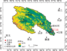
图1
长江源区示意图"

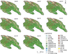
图2
长江源区1980—2020年土地利用变化"

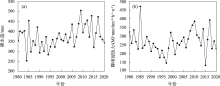
图3
长江源区1980—2020年年降水量(a)和降雨侵蚀力(b)变化"


图4
长江源区K值(a)及LS值(b)空间分布"
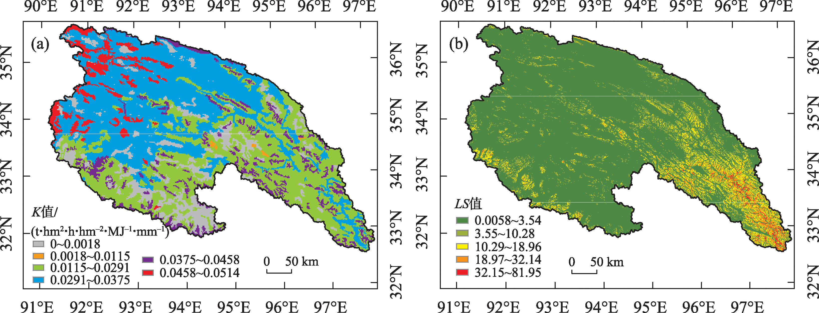
表1
不同土地利用类型的B值"
| 土地利用类型 | B值 | 土地利用类型 | B值 |
|---|---|---|---|
| 旱地 | 1 | 城镇用地 | 0.01 |
| 有林地 | 0.01 | 农村居民点 | 0.025 |
| 灌木林地 | 0.1 | 建设用地 | 0.1 |
| 疏林地 | 0.1 | 水体 | 0 |
| 其他林地 | 0.2 | 其他未利用地 | 0 |
| 高覆盖草地 | 0.12 | 沼泽地 | 0.05 |
| 中覆盖草地 | 0.18 | ||
| 低覆盖草地 | 0.32 |
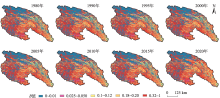
图5
不同年份生物措施因子值空间分布"

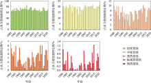
图6
长江源区1980—2020年土壤侵蚀强度面积占比变化"

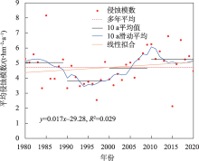
图7
长江源区1980—2020年土壤侵蚀模数变化"
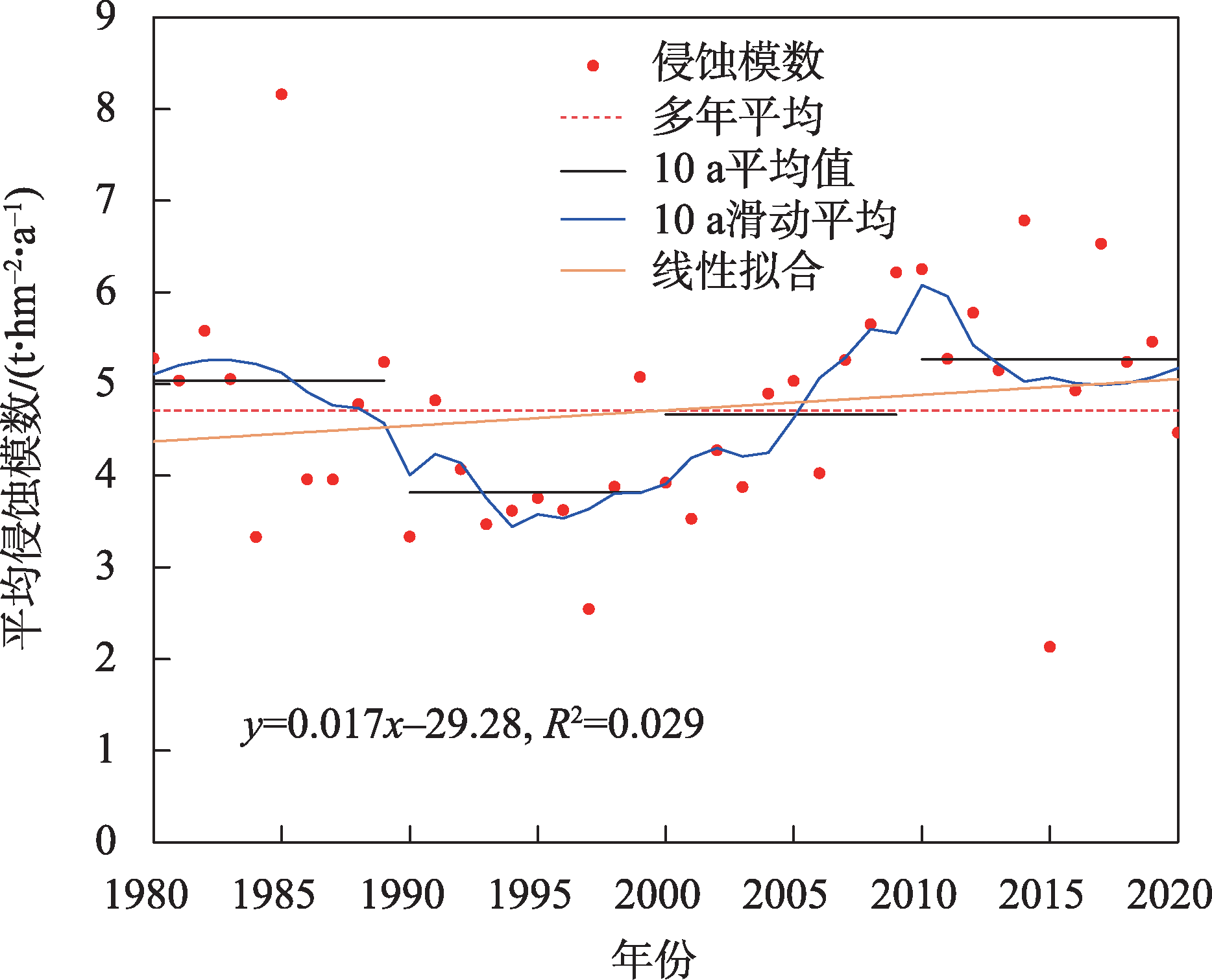
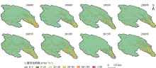
图8
长江源区1980—2020年土壤侵蚀模数空间分布"

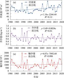
图9
长江源区1980—2020年径流量(a)、含沙量(b)和输沙量(c)的变化趋势"

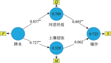
图10
长江源区1980—2020年降水、土壤侵蚀与水沙变化耦合关系 注:P为年降水量,M为年土壤侵蚀量,Q为年径流量,S为年输沙量;**表示0.01水平上相关,*表示0.05水平上相关。下同。"
表2
1980—2020年长江源区降水、土壤侵蚀、径流和输沙量路径效应"
| 路径 | 直接效应 | 间接效应 | 总效应 |
|---|---|---|---|
| P?M | 0.727 | - | 0.727 |
| P?Q | 0.837 | - | 0.837 |
| P?S | - | 0.696 | 0.696 |
| Q?S | 0.885 | - | 0.885 |
| M?S | 0.062 | - | 0.062 |
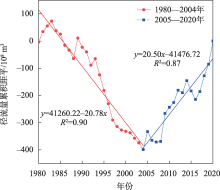
图11
长江源区1980—2020年径流量累积距平变化"

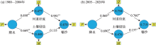
图12
长江源区1980—2004年和2005—2020年降水、土壤侵蚀与水沙变化耦合关系"

表3
1998—2009年、2010—2018年土地利用、植被覆盖变化与径流、泥沙相关性分析"
| 时期 | NDVI | 草地 | 水体 | 未利用地 | |
|---|---|---|---|---|---|
| 1998—2009年 | 径流量 | 0.538 | -0.146 | 0.403 | -0.028 |
| 输沙量 | 0.426 | -0.068 | 0.145 | -0.184 | |
| 土壤侵蚀 | -0.300 | - | - | - | |
| 2010—2018年 | 径流量 | 0.614 | 0.302 | -0.302 | 0.302 |
| 输沙量 | 0.619 | 0.135 | -0.135 | 0.135 | |
| 土壤侵蚀 | 0.740* | - | - | - |
| [1] |
Walling D E, Fang D. Recent trends in the suspended sediment loads of the world’s rivers[J]. Global Planet Change, 2003, 39: 111-126.
doi: 10.1016/S0921-8181(03)00020-1 |
| [2] |
Gebremicael T G, Mohamed Y A, Betrie G D, et al. Trend analysis of runoff and sediment fluxes in the Upper Blue Nile basin: A combined analysis of statistical tests, physically-based models and landuse maps[J]. Journal of Hydrology, 2013, 482: 57-68.
doi: 10.1016/j.jhydrol.2012.12.023 |
| [3] | Meade R H, Moody J A. Causes for the decline of suspended-sediment discharge in the Mississippi River system, 1940-2007[J]. Hydrological Processes, 2010, 24(1): 35-49. |
| [4] |
Wang Shuai, Fu Bojie, Piao Shilong, et al. Reduced sediment transport in the Yellow River due to anthropogenic changes[J]. Nature Geoscience, 2016, 9(1): 38-41.
doi: 10.1038/NGEO2602 |
| [5] |
Zhang Fan, Zeng Chen, Wang Guanxing, et al. Runoff and sediment yield in relation to precipitation, temperature and glaciers on the Tibetan Plateau[J]. International Soil and Water Conservation Research, 2022, 10(2): 197-207.
doi: 10.1016/j.iswcr.2021.09.004 |
| [6] | 王学良, 陈仁升, 刘俊峰, 等. 1956—2021年疏勒河流域主要河流出山径流变化及成因分析[J]. 干旱区研究, 2022, 39(6): 1782-1792. |
| [Wang Xueliang, Chen Rensheng, Liu Junfeng, et al. Changes in runoff from major rivers and analysis of its causes in the Shule River Basin from 1956-2021[J]. Arid Zone Research, 2022, 39(6): 1782-1792. ] | |
| [7] | 赵蒙恩, 闫庆武, 刘政婷, 等. 鄂尔多斯市土壤侵蚀时空演变及影响因子分析[J]. 干旱区研究, 2022, 39(6): 1819-1831. |
| [Zhao Meng’en, Yan Qingwu, Liu Zhengting, et al. Analysis of temporal and spatial evolution and influencing factors of soil erosion in Ordos City[J]. Arid Zone Research, 2022, 39(6): 1819-1831. ] | |
| [8] |
孙鸿烈, 郑度, 姚檀栋, 等. 青藏高原国家生态安全屏障保护与建设[J]. 地理学报, 2012, 67(1): 3-12.
doi: 10.11821/xb201201001 |
|
[Sun Honglie, Zheng Du, Yao Tandong, et al. Protection and construction of the national ecological security shelter zone on Tibetan Plateau[J]. Acta Geographica Sinica, 2012, 67(1): 3-12. ]
doi: 10.11821/xb201201001 |
|
| [9] | 关颖慧, 王淑芝, 温得平. 长江源区水沙变化特征及成因分析[J]. 泥沙研究, 2021, 46(3): 43-49, 56. |
| [Guan Yinghui, Wang Shuzhi, Wen Deping. Processes of runoff and sediment load in the source regions of the Yangtze River[J]. Journal of Sediment Research, 2021, 46(3): 43-49, 56. ] | |
| [10] | 潘佳佳, 郭新蕾, 王涛, 等. 长江源区年际冰水情变化及其影响因子分析[J]. 中国水利水电科学研究院学报, 2023, 21(1): 64-73. |
| [Pan Jiajia, Guo Xinlei, Wang Tao, et al. River ice-flow situations and interannual variations in the source region of the Yangtze River on the Tibetan Plateau[J]. Journal of China Institute of Water Resources and Hydropower Research, 2023, 21(1): 64-73. ] | |
| [11] | 刘彦, 张建军, 张岩, 等. 三江源区近数十年河流输沙及水沙关系变化[J]. 中国水土保持科学, 2016, 14(6): 61-69. |
| [Liu Yan, Zhang Jianjun, Zhang Yan, et al. Variations of riverine sediment and the relationship between runoff and sediment in the source region of three rivers[J]. Science of Soil and Water Conservation, 2016, 14(6): 61-69. ] | |
| [12] |
Naveed A, Wang Genxu, Martijn J, et al. Separation of the impact of landuse/landcover change and climate change on runoff in the Upstream area of the Yangtze River, China[J]. Water Resources Management, 2022, 36(1): 181-201.
doi: 10.1007/s11269-021-03021-z |
| [13] |
Pavisorn C, Xu Mengzhen, Tang Wenzhe. Predicted trends of soil erosion and sediment yield from future land use and climate change scenarios in the Lancang-Mekong River by using the modified RUSLE model[J]. International Soil and Water Conservation Research, 2020, 8(3): 1-47.
doi: 10.1016/j.iswcr.2020.01.001 |
| [14] |
Zhang Fan, Shi Xiaonan, Zeng Chen. Recent stepwise sediment flux increase with climate change in the Tuotuo River in the central Tibetan Plateau[J]. Science Bulletin, 2020, 65(5): 410-418.
doi: 10.1016/j.scib.2019.12.017 pmid: 36659232 |
| [15] |
Teng Hongfen, Liang Zongzhang, Chen Songchao, et al. Current and future assessments of soil erosion by water on the Tibetan Plateau based on RUSLE and CMIP5 climate models[J]. Science of the Total Environment, 2018, 635: 673-686.
doi: 10.1016/j.scitotenv.2018.04.146 |
| [16] |
Wang Yousheng, Cheng Congcong, Xie Yun, et al. Increasing trends in rainfall-runoff erosivity in the Source Region of the Three Rivers, 1961-2012[J]. Science of the Total Environment, 2017, 592: 639-648.
doi: 10.1016/j.scitotenv.2017.02.235 |
| [17] | 苏远逸, 冯朝红, 张扬, 等. 黄土丘陵区覆沙坡面产流产沙过程及水沙关系[J]. 干旱区研究, 2022, 39(4): 1166-1173. |
| [Su Yuanyi, Feng Chaohong, Zhang Yang, et al. Runoff and sediment yield and relationship between water and sediment of sand covered slope of Loess Hilly Region[J]. Arid Zone Research, 2022, 39(4): 1166-1173. ] | |
| [18] | 张凡, 史晓楠, 曾辰, 等. 青藏高原河流输沙量变化与影响[J]. 中国科学院院刊, 2019, 34(11): 1274-1284. |
| [Zhang Fan, Shi Xiaonan, Zeng Chen, et al. Variation and influence of riverine sediment transport from Tibetan Plateau, China[J]. Bulletin of Chinese Academy of Sciences, 2019, 34(11): 1274-1284. ] | |
| [19] | Liu Baoyuan, Zhang Keli, Xie Yun, et al. An Empirical Soil Loss Equation[N]. Beijing: 12th ISCO Conference, 2002. |
| [20] | 章文波, 谢云, 刘宝元. 降雨侵蚀力研究进展[J]. 水土保持学报, 2002, 16(5): 43-46. |
| [Zhang Wenbo, Xie Yun, Liu Baoyuan. Rainfall erosivity estimation using daily rainfall amounts[J]. Scientia Geographica Sinica, 2002, 16(5): 43-46. ] | |
| [21] | 张科利, 彭文英, 杨红丽. 中国土壤可蚀性值及其估算[J]. 土壤学报, 2007, 44(1): 7-13. |
| [Zhang Keli, Peng Wenying, Yang Hongli. Soil erodibility and its estimation for agricultural soil in China[J]. Acta Pedologica Sinica, 2007, 44(1): 7-13. ] | |
| [22] |
Liu Honghu, Kiesel J, Hörmann G, et al. Effects of DEM horizontal resolution and methods on calculating the slope length factor in gently rolling landscapes[J]. Catena, 2011, 87(3): 368-375.
doi: 10.1016/j.catena.2011.07.003 |
| [23] |
Fu Bojie, Zhao Wenwu, Chen Lidong, et al. Assessment of soil erosion at large watershed scale using RUSLE and GIS: A case study in the Loess Plateau of China[J]. Land Degradation & Development, 2005, 16(1): 73-85.
doi: 10.1002/ldr.v16:1 |
| [24] |
Guo Qiankun, Liu Baoyuan, Xie Yun, et al. Estimation of USLE crop and management factor values for crop rotation systems in China[J]. Journal of Integrative Agriculture, 2020, 14(9): 1877-1888.
doi: 10.1016/S2095-3119(15)61097-8 |
| [25] | 杜俊, 师长兴, 周园园. 长江上游侵蚀产沙格局及其控制因素[J]. 山地学报, 2010, 28(6): 660-667. |
| [Du Jun, Shi Changxing, Zhou Yuanyuan. Sediment yield pattern and its controlling factors in the Upper Yangtze River[J]. Journal of Mountain Science, 2010, 28(6): 660-667. ] | |
| [26] | Chin W W, Marcoulides G. The partial least squares approach to structural equation modeling[J]. Advances in Hospitality and Lsure, 1998, 295: 295-336. |
| [27] | 刘强, 尉飞鸿, 常康飞, 等. 皇甫川流域水沙变化特征及其影响因素[J]. 干旱区研究, 2021, 38(6): 1506-1513. |
| [Liu Qiang, Wei Feihong, Chang Kangfei, et al. Characteristics of water and sediment variation in the Huangfuchuan basin and its influencing factors[J]. Arid Zone Research, 2021, 38(6): 1506-1513. ] | |
| [28] |
Liu Baoyuan, Xie Yun, Li Zhiguang, et al. The assessment of soil loss by water erosion in China[J]. International Soil and Water Conservation Research, 2020, 7(2): 1-16.
doi: 10.1016/j.iswcr.2018.11.001 |
| [29] |
魏梦美, 符素华, 刘宝元. 青藏高原水力侵蚀定量研究进展[J]. 地球科学进展, 2021, 36(7): 740-752.
doi: 10.11867/j.issn.1001-8166.2021.072 |
|
[Wei Mengmei, Fu Suhua, Liu Baoyuan. Quantitative research of water erosion on the Qinghai-Tibet Plateau[J]. Advances in Earth Science, 2021, 36(7): 740-752. ]
doi: 10.11867/j.issn.1001-8166.2021.072 |
|
| [30] | 于文竹. 基于模型模拟及核素示踪的三江源土壤侵蚀研究[D]. 兰州: 兰州大学, 2021. |
| [Yu Wenzhu. Study on Soil Erosion of Three River Source Region Based on Erosion Model and Nuclide Tracer Technique[D]. Lanzhou: Lanzhou University, 2021. ] | |
| [31] | 刘杰, 骆婵娟, 曹江源, 等. 青海三江源区土壤侵蚀现状及其分布[J]. 中国水土保持, 2010, 9(2): 49-51. |
| [Liu Jie, Luo Chanjuan, Cao Jiangyuan, et al. Present status and distribution of soil erosion of the Three-River-Source area in Qinghai[J]. Soil and Water Conservation in China, 2010, 9(2): 49-51. ] | |
| [32] | 张平仓, 刘纪根. 长江源区水土流失考察初析[J]. 人民长江, 2011, 42(19): 95-99. |
| [Zhang Pingcang, Liu Jigen. Preliminary analysis on investigation of soil and water loss in source regions of Yangtze River[J]. Yangtze River, 2011, 42(19): 95-99. ] | |
| [33] |
唐见, 曹慧群, 陈进. 生态保护工程和气候变化对长江源区植被变化的影响量化[J]. 地理学报, 2019, 74(1): 76-86.
doi: 10.11821/dlxb201901006 |
|
[Tang Jian, Cao Huiqun, Chen Jin. Effects of ecological conservation projects and climate variations on vegetation changes in the Source Region of Yangtze River[J]. Acta Geographica Sinica, 2019, 74(1): 76-86. ]
doi: 10.11821/dlxb201901006 |
|
| [34] |
邵全琴, 刘树超, 宁佳, 等. 2000—2019年中国重大生态工程生态效益遥感评估[J]. 地理学报, 2022, 77(9): 2133-2153.
doi: 10.11821/dlxb202209001 |
|
[Shao Quanqin, Liu Shuchao, Ning Jia, et al. Assessment of ecological benefits of key national ecological projects in China in 2000-2019 using remote sensing[J]. Acta Geographica Sinica, 2022, 77(9): 2133-2153. ]
doi: 10.11821/dlxb202209001 |
|
| [35] |
邵全琴, 樊江文, 刘纪远, 等. 三江源生态保护和建设一期工程生态成效评估[J]. 地理学报, 2016, 71(1): 3-20.
doi: 10.11821/dlxb201601001 |
|
[Shao Quanqin, Fan Jiangwen, Liu Jiyuan, et al. Assessment on the effects of the first-stage ecological conservation and restoration project in Sanjiangyuan region[J]. Acta Geographica Sinica, 2016, 71(1): 3-20. ]
doi: 10.11821/dlxb201601001 |
|
| [36] | 张永勇, 张士锋, 翟晓燕, 等. 三江源区径流演变及其对气候变化的响应[J]. 地理学报, 2012, 22(5): 781-794. |
| [Zhang Yongyong, Zhang Shifeng, Zhai Xiaoyan, et al. Runoff variation in the Three Rivers Source Region and its response to climate change[J]. Acta Geographica Sinica, 2012, 22(5): 781-794. ] | |
| [37] | 李凯. 三江源区径流演变规律及未来变化趋势研究[D]. 武汉: 长江科学院, 2021. |
| [Li Kai. Study on the Evolution Law and Future Trend of Runoff in the Three-River Headwaters Region[D]. Wuhan: Changjiang River Scientific Research Institute, 2021. ] | |
| [38] | 胡光印, 董治宝, 逯军峰, 等. 近30 a来长江源区沙漠化时空演变过程及成因分析[J]. 干旱区地理, 2011, 34(2): 300-308. |
| [Hu Guangyin, Dong Zhibao, Lu Junfeng, et al. Land desertification monitoring in the Source Region of Yangtze River from 1975 to 2005 and the analysis of its causes[J]. Arid Land Geography, 2011, 34(2): 300-308. ] | |
| [39] |
Zokaib S, Naser G h. A study on rainfall, runoff, and soil loss relations at different land uses: A case in Hilkot watershed in Pakistan[J]. International Journal of Sediment Research, 2012, 27: 388-393.
doi: 10.1016/S1001-6279(12)60043-2 |
| [40] |
景可, 焦菊英, 李林育, 等. 输沙量、侵蚀量与泥沙输移比的流域尺度关系——以赣江流域为例[J]. 地理研究, 2010, 29(7): 1163-1170.
doi: 10.11821/yj2010070002 |
|
[Jing Ke, Jiao Juying, Li Linyu, et al. The scale relationship of sediment discharge, erosion amount and sediment delivery ratio in drainage basin: A case study in the Ganjiang River Basin[J]. Geographical Research, 2010, 29(7): 1163-1170. ]
doi: 10.11821/yj2010070002 |
|
| [41] | 周侃, 张健, 虞虎, 等. 国家公园及周边地区人为扰动强度的时空变化与驱动因素——以三江源国家公园为例[J]. 生态学报, 2022, 42(14): 5574-5585. |
| [Zhou Kan, Zhang Jian, Yu Hu, et al. Spatio-temporal varation and drivers of degree of human disturbance in national park and surrounding areas: A case study of Sanjiangyuan National Park[J]. Acta Ecologica Sinica, 2022, 42(14): 5574-5585. ] | |
| [42] | 郭帅, 裴艳茜, 胡胜, 等. 黄河流域植被指数对气候变化的响应及其与水沙变化的关系[J]. 水土保持通报, 2020, 40(3): 1-7. |
| [Guo Shuai, Pei Yanqian, Hu Sheng, et al. Response of vegetation index to climate change and their relationship with runoff-sediment change in Yellow River basin[J]. Bulletin of Soil and Water Conservation, 2020, 40(3): l-7. ] | |
| [43] |
Ji Guangxing, Song Huiyun, Wei Hejie, et al. Attribution analysis of climate and anthropic factors on runoff and vegetation changes in the source area of the Yangtze River from 1982 to 2016[J]. Land, 2021, 10: 612-625.
doi: 10.3390/land10060612 |
| [1] | 赵雨琪, 魏天兴. 1990—2020年黄土高原典型县域植被覆盖变化及影响因素[J]. 干旱区研究, 2024, 41(1): 147-156. |
| [2] | 胡广录,陶虎,焦娇,白元儒,陈海志,麻进. 黑河中游正义峡径流变化趋势及归因分析[J]. 干旱区研究, 2023, 40(9): 1414-1424. |
| [3] | 周小东, 常顺利, 王冠正, 张毓涛, 喻树龙, 张同文. 天山北坡中段雪岭云杉径向生长对气候变化的响应[J]. 干旱区研究, 2023, 40(8): 1215-1228. |
| [4] | 孟乘枫, 仲涛, 郑江华, 王南, 刘泽轩, 任祥源. 昆仑山冰湖分布时空特征及驱动力[J]. 干旱区研究, 2023, 40(7): 1094-1106. |
| [5] | 赵艳芬, 潘伯荣. 气候变化情景下革苞菊属在中国的潜在地理分布[J]. 干旱区研究, 2023, 40(6): 949-957. |
| [6] | 王晓雨, 马瑞, 张富, 胡彦婷, 王玲莉, 蒋承洋, 陈素娥. 关川河上游水沙变化特征及其对降水和水保措施的响应[J]. 干旱区研究, 2023, 40(11): 1765-1775. |
| [7] | 郑欣如, 王树森, 王博, 张欣, 刘静, 胡晶华, 李诗文, 袁亚楠, 王丫博. 采煤沉陷区模拟土壤侵蚀胁迫对黑沙蒿生理生长特性的影响[J]. 干旱区研究, 2023, 40(11): 1806-1814. |
| [8] | 赵明涛, 王超群, 梁美琪, 何彤慧. 银川平原湿地典型沉水植物群落物种多样性对底泥的响应[J]. 干旱区研究, 2023, 40(11): 1815-1823. |
| [9] | 戴君, 胡海珠, 毛晓敏, 张霁. 基于CMIP6多模式预估数据的石羊河流域未来气候变化趋势分析[J]. 干旱区研究, 2023, 40(10): 1547-1562. |
| [10] | 王冠正, 常顺利, 王建萍, 张毓涛, 孙雪娇, 李翔. 不同坡向雪岭云杉天然更新影响因素分析[J]. 干旱区研究, 2023, 40(10): 1661-1669. |
| [11] | 姚岱均, 刘康, 惠俞翔, 王凯欣. 天水麦积山油松树轮宽度对气候变化的响应及其机制[J]. 干旱区研究, 2023, 40(1): 19-29. |
| [12] | 陈红光, 孟凡浩, 萨楚拉, 罗敏, 王牧兰, 刘桂香. 北方牧区草原内陆河流域径流演变特征及其驱动因素分析[J]. 干旱区研究, 2023, 40(1): 39-50. |
| [13] | 赵蒙恩,闫庆武,刘政婷,王文铭,李桂娥,吴振华. 鄂尔多斯市土壤侵蚀时空演变及影响因子分析[J]. 干旱区研究, 2022, 39(6): 1819-1831. |
| [14] | 张昊琛,萨楚拉,孟凡浩,罗敏,王牧兰,高红豆. 内蒙古地表冻融指数动态变化与驱动因素分析[J]. 干旱区研究, 2022, 39(6): 1996-2008. |
| [15] | 王靖文,唐志光,邓刚,胡国杰,桑国庆. 1991—2021年天山融雪末期雪线高度遥感监测研究[J]. 干旱区研究, 2022, 39(5): 1385-1397. |
|
||