Arid Zone Research ›› 2021, Vol. 38 ›› Issue (5): 1442-1451.doi: 10.13866/j.azr.2021.05.27
• Ecology and Environment • Previous Articles Next Articles
MAN Yuanwei( ),LI Jing(),XING Liting
Received:2021-01-11
Revised:2021-03-03
Online:2021-09-15
Published:2021-09-24
Contact:
Jing LI
E-mail:273424159@qq.com;191977276@qq.com
MAN Yuanwei,LI Jing,XING Liting. Development and application of the temperature soil moisture precipitation drought index (TMPDI) based on multi-source remote sensing data[J].Arid Zone Research, 2021, 38(5): 1442-1451.
Add to citation manager EndNote|Reference Manager|ProCite|BibTeX|RefWorks
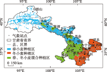
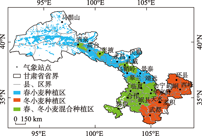
Fig. 1
Schematic diagram of the study area"
Tab. 1
Correlation coefficients between remote sensing drought index and SPI, SPEI"
| 遥感干旱指数 | SPI | SPEI |
|---|---|---|
| SMCI | 0.426 | 0.375 |
| TCI | 0.375 | 0.447 |
| PCI | 0.696 | 0.615 |
| TMPDI | 0.632 | 0.611 |
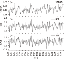
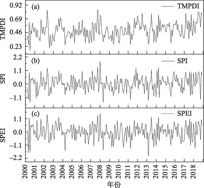
Fig. 2
Variation characteristics of TMPDI, SPI and SPEI in Gansu Province from 2000 to 2018"
Tab. 2
Drought classification of TMPDI"
| 干旱等级 | SPI | SPEI | TMPDI |
|---|---|---|---|
| 无旱 | -0.5<SPI | -0.5<SPEI | 0.45<TMPDI |
| 轻旱 | -1.0<SPI≤-0.5 | -1.0<SPEI≤-0.5 | 0.35<TMPDI≤0.45 |
| 中旱 | -1.5<SPI≤-1.0 | -1.5<SPEI≤-1.0 | 0.25<TMPDI≤0.35 |
| 重旱 | -2.0<SPI≤-1.5 | -2.0<SPEI≤-1.5 | 0.15<TMPDI≤0.25 |
| 特旱 | SPI≤-2.0 | SPEI≤-2.0 | TMPDI≤0.15 |
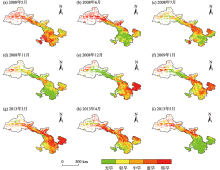
Fig. 3
Distribution of drought monitored by TMPDI in Gansu Province"

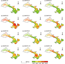
Fig. 4
Distribution of drought monitored by TMPDI in Gansu Province"

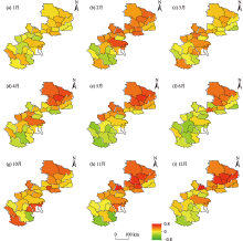
Fig. 5
Distribution of correlation coefficient between winter wheat yield and TMPDI from 2000 to 2018"

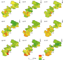
Fig. 6
Distribution of correlation coefficient between winter wheat yield and drought area rate from 2000 to 2018"

Tab. 3
Correlation between wheat yield per unit area and drought intensity and area ratio of spring wheat in main planting counties"
| 3月 | 4月 | 5月 | 6月 | 7月 | ||
|---|---|---|---|---|---|---|
| 民乐县 | TMPDI | 0.135 | 0.059 | 0.437 | 0.624** | 0.231 |
| 干旱面积率 | -0.105 | -0.062 | -0.407 | -0.546* | -0.313 | |
| 山丹县 | TMPDI | 0.315 | 0.099 | 0.383 | 0.543* | 0.248 |
| 干旱面积率 | -0.275 | -0.052 | -0.405 | -0.425 | -0.318 | |
| 天祝县 | TMPDI | 0.177 | 0.399* | 0.403 | 0.136 | 0.013 |
| 干旱面积率 | 0 | -0.350* | -0.368 | -0.086 | 0.009 | |
| 民勤县 | TMPDI | 0.182 | -0.283 | -0.004 | -0.275 | 0.084 |
| 干旱面积率 | 0.121 | -0.340 | 0.050 | -0.216 | 0.174 | |
| 永昌县 | TMPDI | -0.046 | -0.064 | 0.252 | 0.493* | 0.085 |
| 干旱面积率 | 0.022 | -0.011 | -0.152 | -0.451* | -0.289 | |
| 靖远县 | TMPDI | 0.178 | 0 | -0.232 | 0.024 | -0.102 |
| 干旱面积率 | 0.004 | 0.077 | 0.174 | 0.003 | 0.096 | |
| 景泰县 | TMPDI | 0.049 | -0.177 | 0.299 | 0.041 | 0.165 |
| 干旱面积率 | -0.120 | 0.144 | -0.392 | -0.109 | 0.031 |
| [1] |
Liu X, Zhu X, Pan Y, et al. Agricultural drought monitoring: Progress, challenges, and prospects[J]. Journal of Geographical Sciences, 2016, 26(6): 750-767.
doi: 10.1007/s11442-016-1297-9 |
| [2] | Du L, Tian Q, Yu T, et al. A comprehensive drought monitoring method integrating MODIS and TRMM data[J]. International Journal of Applied Earth Observation & Geoinformation, 2013, 23: 245-253. |
| [3] |
Yu F, Price K P, Ellis J, et al. Response of seasonal vegetation development to climatic variations in eastern central Asia[J]. Remote Sensing of Environment, 2003, 87(1): 42-54.
doi: 10.1016/S0034-4257(03)00144-5 |
| [4] | 孙博, 钱静, 陈曦, 等. 常见遥感干旱监测指标在哈萨克斯坦的一致性分析[J]. 干旱区研究, 2020, 37(3): 663-670. |
| [ Sun Bo, Qian Jing, Chen Xi, et al. Consistency and comparison among remote sensing drought indices and SMAP soil moisture in Kazakhstan[J]. Arid Zorn Research, 2020, 37(3): 663-670. ] | |
| [5] | Potopová V, Trnka M, Hamouz P, et al. Statistical modelling of drought-related yield losses using soil moisture-vegetation remote sensing and multiscalar indices in the south-eastern Europe[J]. Agricultural Water Management, 2020, 236: 1-18. |
| [6] |
Hwang T, Gholizadeh H, Sims D A, et al. Capturing species-level drought responses in a temperate deciduous forest using ratios of photochemical reflectance indices between sunlit and shaded canopies[J]. Remote Sensing of Environment, 2017, 199: 350-359.
doi: 10.1016/j.rse.2017.07.033 |
| [7] | 程文举, 席海洋, 司建华, 等. 河西内陆河浅山区流域蒸散发估算及干旱特性研究[J]. 干旱区研究, 2020, 37(5): 1105-1115. |
| [ Cheng Wenju, Xi Haiyang, Si Jianhua, et al. Study of evapotranspiration estimation and drought characteristics of watershed in low coteau area of Hexi inland river[J]. Arid Zone Research, 2020, 37(5): 1105-1115. ] | |
| [8] | McKee T B, Doesken N J, Kleist J. The relationship of drought frequency and duration to time scales[J]. Eighth Conference on Applied Climatology, Anaheim, 1993: 17-24. |
| [9] |
Vicente-Serrano S M, Santiago B, López-Moreno J I. A multiscalar drought index sensitive to global warming: The standardized precipitation evapotranspiration index[J]. Journal of Climate, 2010, 23(7): 1696-1718.
doi: 10.1175/2009JCLI2909.1 |
| [10] | Palmer W C. Meteorological Drought (Research Paper No. 45)[R]. Washington: US Department of Commerce, Weather Bureau, 1965: 45-58. |
| [11] | Bhuiyan C, Singh R P, Kogan F N. Monitoring drought dynamics in the Aravalli region (India) using different indices based on ground and remote sensing data[J]. International Journal of Applied Earth Observation & Geoinformation, 2006, 8(4): 289-302. |
| [12] | Kogan F N. Application of vegetation index and brightness temperature for drought detection[J]. Advances in Space Research, 1995, 15(11): 91-100. |
| [13] | Du L, Tian Q, Yu T, et al. A comprehensive drought monitoring method integrating MODIS and TRMM data[J]. International Journal of Applied Earth Observation & Geoinformation, 2013, 23: 245-253. |
| [14] |
Kogan F N, Stark R, Gitelson A, et al. Derivation of pasture biomass in Mongolia from AVHRR-based vegetation health indices[J]. International Journal of Remote Sensing, 2004, 25(14), 2889-2896.
doi: 10.1080/01431160410001697619 |
| [15] |
Sandholt I, Rasmussen K, Andersen J. A simple interpretation of the surface temperature/vegetation index space for assessment of surface moisture status[J]. Remote Sensing of Environment, 2002, 79 (2-3): 213-224.
doi: 10.1016/S0034-4257(01)00274-7 |
| [16] |
Zhang A, Jia G. Monitoring meteorological drought in semiarid regions using multi-sensor microwave remote sensing data[J]. Remote Sensing of Environment, 2013, 134: 12-23.
doi: 10.1016/j.rse.2013.02.023 |
| [17] |
Campbell B M, Vermeulen S J, Aggarwal P K, et al. Reducing risks to food security from climate change[J]. Global Food Security, 2016, 11: 34-43.
doi: 10.1016/j.gfs.2016.06.002 |
| [18] | 韩兰英, 张强, 赵红岩, 等. 甘肃省农业干旱灾害损失特征及其对气候变暖的响应[J]. 中国沙漠, 2016, 36(3) : 767-776. |
| [ Han Lanying, Zhang Qiang, Zhao Hongyan, et al. The characteristics of agricultural drought disaster loss and response to climate warming in Gansu, China[J]. Journal of Desert Research, 2016, 36(3): 767-776. ] | |
| [19] | 中国气象局. 中国气象灾害年鉴(2004)[M]. 北京: 气象出版社, 2005. |
| [ China Meteorological Administration. Yearbook of Meteorological Disasters in China 2004[M]. Beijing: China Meteorological Press, 2005. ] | |
| [20] | Wei W, Pang S, Wang X, et al. Temperature Vegetation Precipitation Dryness Index (TVPDI)-based dryness-wetness monitoring in China[J]. Remote Sensing of Environment, 2020, 248: 1-18. |
| [21] | 刘德祥, 白虎志, 宁惠芳, 等. 气候变暖对甘肃干旱气象灾害的影响[J]. 冰川冻土, 2006, 28(5): 707-712. |
| [ Liu Dexiang, Bai Huzhi, Ning Huifang, et al. Response of arid meteorological disaster to climatic warming in Gansu Province[J]. Journal of Glaciology and Geocryology, 2006, 28(5): 707-712. ] | |
| [22] |
Ye L, Fang L, Shi Z, et al. Spatio-temporal dynamics of soil moisture driven by ‘Grain for Green’ program on the Loess Plateau, China[J]. Agriculture Ecosystems & Environment, 2019, 269: 204-214.
doi: 10.1016/j.agee.2018.10.006 |
| [23] |
Loon A V. Hydrological drought explained[J]. WIREs Water, 2015, 2: 359-392.
doi: 10.1002/wat2.2015.2.issue-4 |
| [24] | Qi L A, Sha Z A, Hz C, et al. Monitoring drought using composite drought indices based on remote sensing[J]. Science of The Total Environment, 2020, 711: 1-10. |
| [25] |
Mesquita D, Gomes J, Junior A S, et al. Euclidean distance estimation in incomplete datasets[J]. Neurocomputing, 2017, 248: 11-18.
doi: 10.1016/j.neucom.2016.12.081 |
| [26] |
Amani M, Salehi B, Mahdavi S, et al. Temperature-Vegetation-soil Moisture Dryness Index (TVMDI)[J]. Remote Sensing of Environment, 2017, 197: 1-14.
doi: 10.1016/j.rse.2017.05.026 |
| [27] | 张强, 邹旭恺, 肖风劲, 等.气象干旱等级(GB/T 20481-2006)[S]. 北京: 中国标准出版社, 2006: 12-17. |
| [ Zhang Qiang, Zou Xukai, Xiao Fengjin, et al. Classification of Meteorological Drought Category (GB/T20481-2006)[S]. Beijing: Standards Press of China, 2006: 12-17. ] | |
| [28] | 甘肃省地方史志办公室. (甘肃年鉴2019)[M]. 兰州: 甘肃民族出版社, 2019. |
| [Office of Local Chronicles of Gansu Province. Gansu Yearbook 2019[M]. Lanzhou: Gansu Nationalities Publishing House, 2019. ] | |
| [29] |
Mishra A K, Singh V P. A review of drought concepts[J]. Journal of Hydrology, 2010, 391(1-2): 202-216.
doi: 10.1016/j.jhydrol.2010.07.012 |
| [30] |
Daryanto S, Wang L, Jacinthe P A. Global synthesis of drought effects on cereal, legume, tuber and root crops production: A review[J]. Agricultural Water Management, 2016, 179: 18-33.
doi: 10.1016/j.agwat.2016.04.022 |
| [31] |
余慧倩, 张强, 孙鹏, 等. 干旱强度及发生时间对华北平原五省冬小麦产量影响[J]. 地理学报, 2019, 74(1): 87-102.
doi: 10.11821/dlxb201901007 |
|
[ Yu Huiqian, Zhang Qiang, Sun Peng, et al. Impacts of drought intensity and drought duration on winter wheat yield in five provinces of north China plain[J]. Acta Geographica Sinica, 2019, 74(1): 87-102. ]
doi: 10.11821/dlxb201901007 |
|
| [32] |
Çakir R. Effect of water stress at different development stages on vegetative and reproductive growth of corn[J]. Field Crops Research, 2004, 89(1): 1-16.
doi: 10.1016/j.fcr.2004.01.005 |
| [33] |
Wang S, Mo X, Liu S, et al. Validation and trend analysis of ECV soil moisture data on cropland in North China Plain during 1981-2010[J]. International Journal of Applied Earth Observation and Geoinformation, ,2015,, 48: 110-121.
doi: 10.1016/j.jag.2015.10.010 |
| [34] | Anyamba A, Tucker C J. Historical perspectives on AVHRR NDVI and vegetation drought monitoring[J]. NASA Publications, 2012, 217. http://digitalcommons.unl.edu/nasapub/217. |
| [35] |
Loon A V, Laaha G. Hydrological drought severity explained by climate and catchment characteristics[J]. Journal of Hydrology, 2015, 526: 3-14.
doi: 10.1016/j.jhydrol.2014.10.059 |
| [1] | WANG Yiwen, MA Yaoyao, SHI Peijun, ZHANG Gangfeng. The impact of photovoltaic power plant operation on local ecological environments in arid areas [J]. Arid Zone Research, 2024, 41(8): 1423-1433. |
| [2] | MA Yuanzhi, QIN Xiaolin, LING Hongbo, YAN Junjie, ZHANG Guangpeng. Spatio-temporal characteristics and trends of area changes in the small and medium-sized lakes in Xinjiang, China, from 1991 to 2020 [J]. Arid Zone Research, 2024, 41(6): 905-916. |
| [3] | HONG Guojun, XIE Junbo, ZHANG Ling, FAN Zhenqi, YU Caili, FU Xianbing, LI Xu. Monitoring soil salinization of cotton fields in the Aral Reclamation Area using multispectral imaging [J]. Arid Zone Research, 2024, 41(5): 894-904. |
| [4] | ZHANG Hua, YA Haiting, XU Cungang. Remote sensing retrieval of soil moisture and estimation of vegetation water requirements in the north and south mountains of Lanzhou City [J]. Arid Zone Research, 2024, 41(4): 566-580. |
| [5] | WANG Sinan, WU Yingjie, WANG Hongzhou, LI Mingyang, WANG Fei, ZHANG Wenying, MA Xiaoming, YU Xiangqian. Spatial and temporal drivers of drought analysis using the geodetector in Ordos [J]. Arid Zone Research, 2024, 41(12): 1981-1991. |
| [6] | XU Yunhong, LIU Qiong, CHEN Yonghang, WEI Xin, LIU Xin, ZHANG Taixi, SHAO Weiling, YANG Hequn, ZHANG Chengming. Impact of land cover variations on surface albedo in Xinjiang and its surrounding Central Asian region [J]. Arid Zone Research, 2024, 41(10): 1649-1661. |
| [7] | CHEN Chunbo,LI Junli,ZHAO Yan,XIA Jiang,TIAN Weitao,LI Chaofeng. Spatiotemporal dynamics of grassland vegetation and its responses to climate change in Changji Hui Autonomous Prefecture, Xinjiang [J]. Arid Zone Research, 2023, 40(9): 1484-1497. |
| [8] | MA Yaoyao, SHI Peijun, XU Wei, ZHANG Gangfeng. Remote sensing monitoring of the ecological environment of hydropower station construction and operation in arid areas: A case study of Longyangxia Hydropower Station [J]. Arid Zone Research, 2023, 40(9): 1498-1508. |
| [9] | MENG Chengfeng, ZHONG Tao, ZHENG Jianghua, WANG Nan, LIU Zexuan, REN Xiangyuan. Analysis of temporal and spatial characteristics and driving forces of Kunlun glacial lakes [J]. Arid Zone Research, 2023, 40(7): 1094-1106. |
| [10] | LIU Xiao, GUO Peng, QI Jiafeng, DU Wenling, ZHANG Ruqian, ZHANG Kun. Spatio-temporal changes and driving forces in the ecological environment of Altay City determined using an MRSEI model [J]. Arid Zone Research, 2023, 40(6): 1014-1026. |
| [11] | LI Feifei, ZHOU Xia, ZHOU Yuxi. Vulnerability assessment and spatiotemporal distribution of agricultural drought in Northwest China [J]. Arid Zone Research, 2023, 40(4): 663-669. |
| [12] | KANG Ligang, CAO Shengkui, CAO Guangchao, YANG Yufan, YAN Li, WANG Youcai. Temporal and spatial changes of evapotranspiration in the Shaliu River Basin of Qinghai Lake [J]. Arid Zone Research, 2023, 40(3): 358-372. |
| [13] | WU Wanmin, LIU Tao, CHEN Xin. Seasonal changes of NDVI in the arid and semi-arid regions of Northwest China and its influencing factors [J]. Arid Zone Research, 2023, 40(12): 1969-1981. |
| [14] | LI Yankun,GAO Liming,ZHANG Lele,WU Xueqing,LIU Xuanchen,QI Wen. Comparison of downscaling methods for TRMM 3B43 precipitation data in the Qinghai Lake Basin and its surrounding areas [J]. Arid Zone Research, 2022, 39(6): 1706-1716. |
| [15] | WANG Jingwen,TANG Zhiguang,DENG Gang,HU Guojie,SANG Guoqing. Monitoring of snowline altitude at the end of melting season in Tianshan Mountains from 1991 to 2021 [J]. Arid Zone Research, 2022, 39(5): 1385-1397. |
|
||