Arid Zone Research ›› 2023, Vol. 40 ›› Issue (3): 358-372.doi: 10.13866/j.azr.2023.03.03
• Weather and Climate • Previous Articles Next Articles
KANG Ligang1,2( ),CAO Shengkui1,2,3(),CAO Guangchao1,2,3,YANG Yufan4,YAN Li1,2,WANG Youcai1,2
Received:2022-04-22
Revised:2022-06-28
Online:2023-03-15
Published:2023-03-31
KANG Ligang, CAO Shengkui, CAO Guangchao, YANG Yufan, YAN Li, WANG Youcai. Temporal and spatial changes of evapotranspiration in the Shaliu River Basin of Qinghai Lake[J].Arid Zone Research, 2023, 40(3): 358-372.
Add to citation manager EndNote|Reference Manager|ProCite|BibTeX|RefWorks

Fig. 1
Schematic diagram of the Shaliu River Basin in Qinghai Lake"

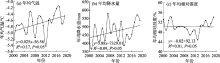
Fig. 2
Interannual variation of average annual temperature (a), average annual precipitation (b) and average annual relative humidity (c) in the Shaliu River Basin of Qinghai Lake"
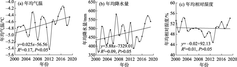

Fig. 3
Spatial distribution of multi-year average temperature (a), multi-year average precipitation (b) and multi-year average relative humidity (c) in the Shaliu River Basin of Qinghai Lake"
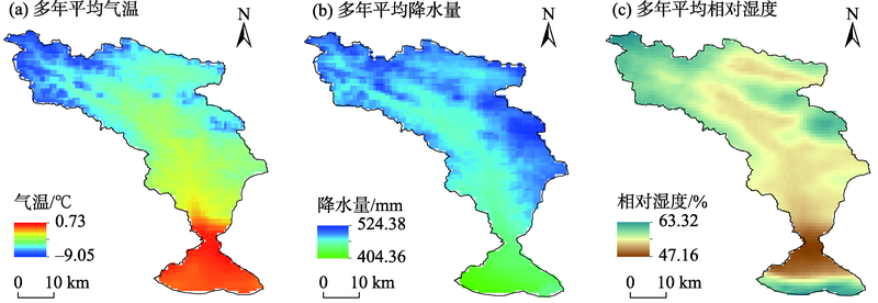
Fig. 4
Spatial trends of annual mean temperature (a), annual mean precipitation (b) and annual mean relative humidity (c)in the Shaliu River Basin of Qinghai Lake"


Fig. 5
Interannual variation of mean annual evapotranspiration in the Shaliu River Basin of Qinghai Lake (a) and its three vegetation type zones (b)"
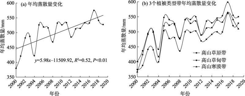

Fig. 6
Spatial distribution of multi-year average evapotranspiration (a) and its trend (b) in the Shaliu River Basin of Qinghai Lake"
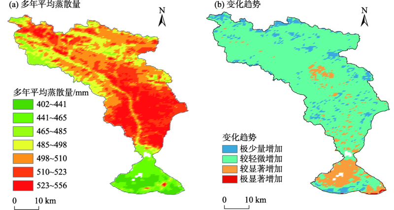
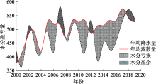
Fig. 7
Interannual variation of water surplus and deficit in the Shaliu River Basin of Qinghai Lake"

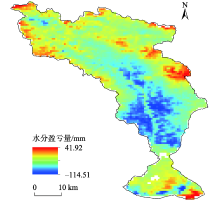
Fig. 8
Spatial distribution of multi-year average moisture gain/loss in the Shaliu River Basin of Qinghai Lake"

Tab. 1
Values of multi-year average evapotranspiration and its interannual variation rate in different vegetation type zones in the Shaliu River Basin of Qinghai Lake"
| 高山草原带 | 高山草甸带 | 高山寒漠带 | |
|---|---|---|---|
| 多年平均蒸散量/mm | 474.1 | 517.5 | 501.9 |
| 蒸散量年际变化率/(mm·a-1) | 6.1 | 5.6 | 5.1 |

Fig. 9
Frequency distribution of evapotranspiration in different vegetation type zones in the Shaliu River Basin of Qinghai Lake"
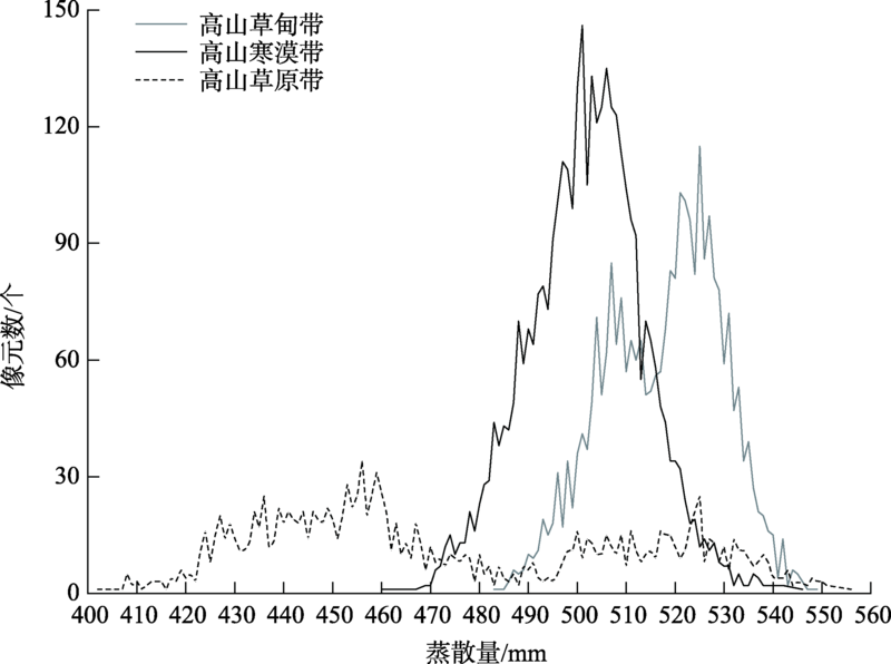

Fig. 10
Correlation (a) and scatter plots (b-d) of annual average evapotranspiration with annual average temperature, annual average precipitation, and annual average relative humidity in the Shaliu River Basin of Qinghai Lake"
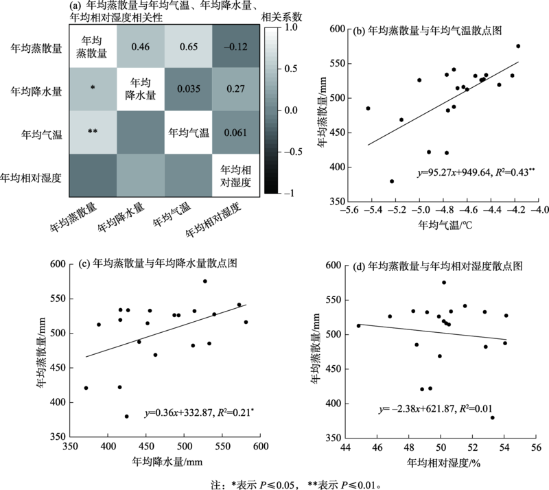
Fig. 11
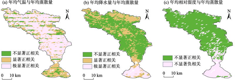
Spatial correlation of annual mean evapotranspiration with annual mean temperature (a), annual mean precipitation (b), and annual mean relative humidity (c) in the Shaliu River Basin of Qinghai Lake"
Tab. 2
Values of multi-year average evapotranspiration and its interannual variability at different slopes in the Shaliu River Basin of Qinghai Lake"
| 平坡 | 缓坡 | 斜坡 | 陡坡 | 急坡 | 险坡 | |
|---|---|---|---|---|---|---|
| 多年平均蒸散量/mm | 493.0 | 509.8 | 508.5 | 505.9 | 511.0 | 510.5 |
| 蒸散量年际变化率/(mm·a-1) | 5.7 | 5.3 | 5.3 | 5.1 | 5.4 | 5.0 |

Fig. 12
Values of multi-year mean evapotranspiration (a) and its interannual variability (b) for different slope directions in the Shaliu River Basin of Qinghai Lake"
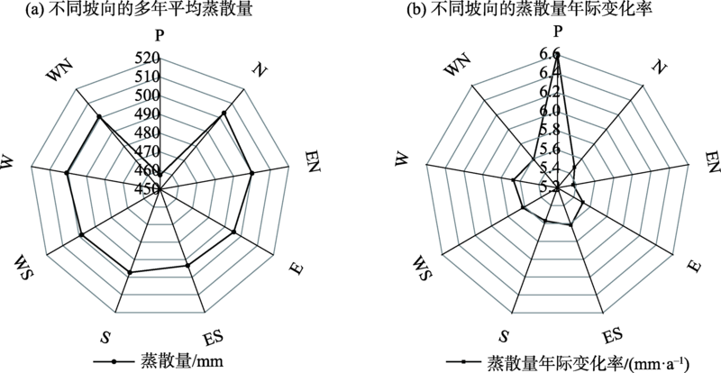
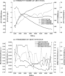
Fig. 13
Values of multi-year average evapotranspiration, multi-year average temperature, multi-year average precipitation, multi-year average relative humidity (a) and their interannual variability (b) at different elevations in the Shaliu River Basin of Qinghai Lake"

| [1] | 李晴, 杨鹏年, 彭亮, 等. 基于MOD16数据的焉耆盆地蒸散量变化研究[J]. 干旱区研究, 2021, 38(2): 351-358. |
| [Li Qing, Yang Pengnian, Peng Liang, et al. Study of the variation trend of evapotranspiration in the Yanqi Basin based on MOD16 data[J]. Arid Zone Research, 2021, 38(2): 351-358.] | |
| [2] |
Lu X, Zang C, Burenina T. Study on the variation in evapotranspiration in different period of the Genhe River Basin in China[J]. Physics and Chemistry of the Earth, Parts A/B/C, 2020, 120: 102902.
doi: 10.1016/j.pce.2020.102902 |
| [3] |
Huntington T G. Evidence for intensification of the global water cycle: Review and synthesis[J]. Journal of Hydrology, 2006, 319(1-4): 83-95.
doi: 10.1016/j.jhydrol.2005.07.003 |
| [4] |
Yu L, Josey S A, Bingham F M, et al. Intensification of the global water cycle and evidence from ocean salinity: A synthesis review[J]. Annals of the New York Academy of Sciences, 2020, 1472(1): 76-94.
doi: 10.1111/nyas.14354 pmid: 32386251 |
| [5] | 史孟琦, 袁喆, 史晓亮, 等. 基于GLDAS-NOAH的长江流域蓝绿水资源时空变化特征[J]. 长江科学院院报, 2022, 39(10): 38-44, 53. |
| [Shi Mengqi, Yuan Zhe, Shi Xiaoliang, et al. Spatial and temporal variation characteristics of blue and green water resources in the Yangtze River Basin based on GLDAS-NOAH[J]. Journal of Yangtze River Scientific Research Institute, 2022, 39(10): 38-44, 53.] | |
| [6] | 杨晓甜, 张建云, 鲍振鑫, 等. 黄淮海流域实际蒸散发时空演变规律分析[J]. 水利水运工程学报, 2022, 44(3): 12-22. |
| [Yang Xiaotian, Zhang Jianyun, Bao Zhenxin, et al. Temporal and spatial distribution characteristics of evapotranspiration in the Huang-Huai-Hai River Basin[J]. Hydro-Science and Engineering, 2022, 44(3): 12-22.] | |
| [7] | 郭晓彤, 孟丹, 蒋博武, 等. 基于MODIS蒸散量数据的淮河流域蒸散发时空变化及影响因素分析[J]. 水文地质工程地质, 2021, 48(3): 45-52. |
| [Guo Xiaotong, Meng Dan, Jiang Bowu, et al. Spatio-temporal change and influencing factors of evapotranspiration in the Huaihe River Basin based on MODIS evapotranspiration data[J]. Hydrogeology& Engineering Geology, 2021, 48(3): 45-52.] | |
| [8] | 梁红闪, 王丹, 郑江华. 伊犁河流域地表蒸散量时空特征分析[J]. 灌溉排水学报, 2020, 39(7): 100-110. |
| [Liang Hongshan, Wang Dan, Zheng Jianghua. Temporal and spatial characteristics of surface evapotranspiration in the Ili River Basin[J]. Journal of Irrigation and Drainage, 2020, 39(7): 100-110.] | |
| [9] | 蒙雨, 但文红, 王焕. 基于MOD16的乌江流域地表蒸散发时空特征及影响因素[J]. 水土保持研究, 2020, 27(6): 139-145. |
| [Meng Yu, Dan Wenhong, Wang Huan. Spatiotemporal characteristics of evapotranspiration and its affecting factors in Wujiang Basin based on MOD16[J]. Research of Soil and Water Conversation, 2020, 27(6): 139-145.] | |
| [10] |
褚荣浩, 李萌, 谢鹏飞, 等. 安徽省近20年地表蒸散和干旱变化特征及其影响因素分析[J]. 生态环境学报, 2021, 30(6): 1229-1239.
doi: 10.16258/j.cnki.1674-5906.2021.06.014 |
|
[Chu Ronghao, Li Meng, Xie Pengfei, et al. Characteristics and influencing factors of surface evapotranspiration and drought in Anhui Province during recent 20 years[J]. Ecology and Environmental Sciences, 2021, 30(6): 1229-1239.]
doi: 10.16258/j.cnki.1674-5906.2021.06.014 |
|
| [11] |
温媛媛, 赵军, 王炎强, 等. 基于MOD16的山西省地表蒸散发时空变化特征分析[J]. 地理科学进展, 2020, 39(2): 255-264.
doi: 10.18306/dlkxjz.2020.02.007 |
|
[Wen Yuanyuan, Zhao Jun, Wang Yanqiang, et al. Spatiotemporal variation characteristics of surface evapotranspiration in Shanxi Province based on MOD16[J]. Progress in Geography, 2020, 39(2): 255-264.]
doi: 10.18306/dlkxjz.2020.02.007 |
|
| [12] | 姚檀栋, 陈发虎, 崔鹏, 等. 从青藏高原到第三极和泛第三极[J]. 中国科学院院刊, 2017, 32(9): 924-931. |
| [Yao Tandong, Chen Fahu, Cui Peng, et al. From Tibetan Plateau to Third Pole and Pan-Third Pole[J]. China Academic Journal Electronic Publishing House, 2017, 32(9): 924-931.] | |
| [13] | 陈德亮, 徐柏青, 姚檀栋, 等. 青藏高原环境变化科学评估: 过去, 现在与未来[J]. 科学通报, 2015, 60(32): 3025-3035, 1-2. |
| [Chen Deliang, Xu Baiqing, Yao Tandong, et al. Assessment of past, present and future environmental changes on the Tibetan Plateau[J]. Chinese Science Bulletin, 2015, 60(32): 3025-3035, 1-2.] | |
| [14] | 姚檀栋, 朴世龙, 沈妙根, 等. 印度季风与西风相互作用在现代青藏高原产生连锁式环境效应[J]. 中国科学院院刊, 2017, 32(9): 976-984. |
| [Yao Tandong, Piao Shilong, Shen Miaogen, et al. Chained impacts on modern environment of interaction between westerlies and Indian monsoon on Tibetan Plateau[J]. China Academic Journal Electronic Publishing House, 2017, 32(9): 976-984.] | |
| [15] | 李岳坦, 李小雁, 崔步礼, 等. 青海湖流域及周边地区蒸发皿蒸发量变化(1961—2007年)及趋势分析[J]. 湖泊科学, 2010, 22(4): 616-624. |
| [LI Yuetan, Li Xiaoyan, Cui Buli, et al. Trend of pan evaporation and its impact factors over Lake Qinghai Basin from 1961 to 2007[J]. Lake Science, 2010, 22(4): 616-624.] | |
| [16] | Chen J L, Yang H, Lu M Q, et al. Estimation of monthly pan evaporation using support vector machine in Three Gorges Reservoir Area, China[J]. Theoretical and Applied Climatology, 2019, (4): 1-13. |
| [17] |
田凤云, 吴成来, 张贺, 等. 基于CAS-ESM2的青藏高原蒸散发的模拟与预估[J]. 地球科学进展, 2021, 36(8): 797-809.
doi: 10.11867/j.issn.1001-8166.2021.084 |
|
[Tian Fengyun, Wu Chenglai, Zhang He, et al. Simulation and projection of evapotranspiration over the Tibetan Plateau based on CAS-ESM2[J]. Advances in Earth Science, 2021, 36(8): 797-809.]
doi: 10.11867/j.issn.1001-8166.2021.084 |
|
| [18] |
Gao Y, Zhao C, Ashiq M W, et al. Actual evapotranspiration of subalpine meadows in the Qilian Mountains, Northwest China[J]. Journal of Arid Land, 2019, 11(3): 371-384.
doi: 10.1007/s40333-019-0012-y |
| [19] | 张耀宗, 张勃, 张多勇, 等. 1960—2018年黄土高原地区蒸发皿蒸发时空变化特征及影响因素[J]. 干旱区研究, 2022, 39(1): 1-9. |
| [Zhang Yaozong, Zhang Bo, Zhang Duoyong, et al. Spatio temporal patterns of pan evaporation from 1960 to 2018 over the Loess Plateau: Changing properties and possible causes[J]. Arid Zone Research, 2022, 39(1): 1-9.] | |
| [20] | 汉光昭, 曹广超, 曹生奎, 等. 基于Shuttleworth-Wallace模型的小泊湖和沙柳河河源区湿地蒸散发模拟研究[J]. 湿地科学, 2019, 17(5): 519-526. |
| [Han Guangzhao, Cao Guangchao, Cao Shengkui, et al. Simulation of evapotranspiration of Xiaopo Lake and Shaliu River Headwater Wetlands based on Shuttleworth-Wallace Model[J]. Wetland Science, 2019, 17(5): 519-526.] | |
| [21] | 王志刚, 曹生奎, 曹广超, 等. 青海湖沙柳河河源区降水同位素云下二次蒸发效应[J]. 地球与环境, 2022, 50(1): 83-93. |
| [Wang Zhigang, Cao Shengkui, Cao Guanchao, et al. Effects of secondary evaporation under clouds on the precipitation isotope in the Headwater Area of Shaliu River, Qinghai Lake[J]. Earth And Environment, 2022, 50(1): 83-93.] | |
| [22] |
Cui B L, Li X Y. Runoff processes in the Qinghai Lake Basin, Northeast Qinghai-Tibet Plateau, China: Insights from stable isotope and hydrochemistry[J]. Quaternary International, 2015, 380-381(4): 123-132.
doi: 10.1016/j.quaint.2015.02.030 |
| [23] | 杨羽帆, 曹生奎, 冯起, 等. 青海湖沙柳河流域浅层地下水氢氧稳定同位素分布特征[J]. 中国沙漠, 2019, 39(5): 45-53. |
| [Yang Yufan, Cao Shengkui, Feng Qi, et al. Spatial distribution characteristics of composition of stable hydrogen and oxygen isotopes of shallow groundwater in Shaliu River Basin of Qinghai Lake[J]. Journal of Desert Research, 2019, 39(5): 45-53.] | |
| [24] |
An Z S, Colman S M, Zhou W J, et al. Interplay between the Westerlies and Asian monsoon recorded in Lake Qinghai sediments since 32 ka[J]. Scientific Reports, 2012, 2(8): 619.
doi: 10.1038/srep00619 |
| [25] |
雷义珍, 曹生奎, 曹广超, 等. 青海湖沙柳河流域不同时期地表水与地下水的相互作用[J]. 自然资源学报, 2020, 35(10): 2528-2538.
doi: 10.31497/zrzyxb.20201017 |
|
[Lei Yizhen, Cao Shengkui, Cao Guangchao, et al. Study on surface water and groundwater interaction of Shaliu River Basin in Qinghai Lake in different periods[J]. Journal of Natural Resources, 2020, 35(10): 2528-2538.]
doi: 10.31497/zrzyxb.20201017 |
|
| [26] | 中华人民共和国生态环境部. 全国生态状况调查评估技术规范——草地生态系统野外观测(HJ1168-2021)[S]. 北京: 中国标准出版社, 2021. |
| [Ministry of Ecology and Environment of the People’s Republic of China. Technical Specification for Investigation and Assessment of National Ecological Status: Field Observation of Grassland Ecosystem (HJ1168-2021)[S]. Beijing: China Standards Press, 2021.] | |
| [27] |
黄葵, 卢毅敏, 魏征, 等. 土地利用和气候变化对海河流域蒸散发时空变化的影响[J]. 地球信息科学学报, 2019, 21(12): 1888-1902.
doi: 10.12082/dqxxkx.2019.190269 |
|
[Huang Kui, Lu Yimin, Wei Zheng, et al. Effects of land use and climate change on spatiotemporal changes of evapotranspiration in Haihe River Basin[J]. Journal of Geo-information Science, 2019, 21(12): 1888-1902.]
doi: 10.12082/dqxxkx.2019.190269 |
|
| [28] | 刘燕, 刘友存, 陈明, 等. 基于Penman-Monteith的江南丘陵地区地表参考蒸散量和水分盈亏量特征分析[J]. 安徽农业大学学报, 2019, 46(4): 680-688. |
| [Liu Yan, Liu Youcun, Chen Ming, et al. Analysis on the variation characteristics of surface water in the Jiangnan Hills based on the Penman-Monteith method[J]. Journal of Anhui Agricultural University, 2019, 46(4): 680-688.] | |
| [29] | 李净, 王丹. 3种不同遥感辐射产品的精度比较[J]. 气候与环境研究, 2018, 23(2): 252-258. |
| [Li Jing, Wang Dan. A comparative study on three types of remote sensing solar radiation products[J]. Climatic and Environmental Research, 2018, 23(2): 252-258.] | |
| [30] | 王志刚, 曹生奎, 曹广超. 近15年来青海湖流域气温, 降水变化对植被物候驱动分析[J]. 水土保持研究, 2022, 29(1): 249-255. |
| [Wang Zhigang, Cao Shengkui, Cao Guanchao. Changes in temperature and precipitation in Qinghai Lake Basin in the past 15 years have driven analysis of vegetation phenology[J]. Research of Soil and Water Conversation, 2022, 29(1): 249-255.] | |
| [31] |
Zhang Y, Pea-arancibia J L, Mcvicar T R, et al. Multi-decadal trends in global terrestrial evapotranspiration and its components[J]. Scientific Reports, 2016, 6(1): 19124.
doi: 10.1038/srep19124 |
| [32] |
马宁. 近40年来青藏高原典型高寒草原和湿地蒸散发变化的对比分析[J]. 地球科学进展, 2021, 36(8), 836-848.
doi: 10.11867/j.issn.1001-8166.2021.079 |
|
[Ma Ning. Comparative analysis of evapotranspiration changes in typical alpine grasslands and wetlands on the Qinghai-Tibet Plateau in the past 40 years[J]. Advances In Earth Science, 2021, 36(8): 836-848.]
doi: 10.11867/j.issn.1001-8166.2021.079 |
|
| [33] | 李艳君. 2010—2019年青海湖流域蒸散发及对气候变化的响应[J]. 佳木斯大学学报(自然科学版), 2022, 40(2): 116-118, 122. |
| [LiYanjun. The evapotranspiration and its response to climate[J]. Journal of Jiamusi University (Natural Science Edition), 2022, 40(2): 116-118, 122.] | |
| [34] | 金晓媚, 郭任宏, 夏薇. 基于MODIS数据的柴达木盆地区域蒸散量的变化特征[J]. 水文地质工程地质, 2013, 40(6): 8-13. |
| [Jin Xiaomei, Guo Renhong, Xia Wei. Variation of regional evapotranspiration of Qaidam Basin using MODIS data[J]. Hydrogeology & Engineering Geology, 2013, 40(6): 8-13.] |
| [1] | XIE Gang, WANG Tiantian, YU Tao, DONG Jingwei, CHEN Shiqiang, WANG Mengxiao, ZHANG Shengjie, ZHANG Haoming. A preliminary study on the evolution of water temperature in the estuary of the Qinghai Lake [J]. Arid Zone Research, 2024, 41(9): 1503-1513. |
| [2] | WANG Jiashuang, GAO Xiaoyu, LI Weiping, CHI Zhaonan, ZHANG Jiapeng, WU Yixuan. Spatial-temporal variation characteristics and attribution analysis of potential evapotranspiration in the Tabu River Basin [J]. Arid Zone Research, 2024, 41(9): 1538-1547. |
| [3] | YAO Xiaochen, GAO Fan, HAN Fanghong, HE Bing. Land use intensity change and its influence on evapotranspiration in Aksu River Basin from 2000 to 2020 [J]. Arid Zone Research, 2024, 41(6): 951-963. |
| [4] | XU Chaojie, DOU Yan, MENG Qilin. Prediction of the standardized precipitation evapotranspiration index in the Xinjiang region using the EMD-GWO-LSTM model [J]. Arid Zone Research, 2024, 41(4): 527-539. |
| [5] | MA Longlong, YI Zhiyuan, WEI Caiyong, ZHOU Feng, LI Mingtao, QIAO Chenglong, DU Lingtong. Temporal and spatial characteristics of ecosystem water use efficiency and influencing factors in Yanchi County, Ningxia, China [J]. Arid Zone Research, 2024, 41(4): 650-660. |
| [6] | XU Yunhong, LIU Qiong, CHEN Yonghang, WEI Xin, LIU Xin, ZHANG Taixi, SHAO Weiling, YANG Hequn, ZHANG Chengming. Impact of land cover variations on surface albedo in Xinjiang and its surrounding Central Asian region [J]. Arid Zone Research, 2024, 41(10): 1649-1661. |
| [7] | LI Yongguang, YUAN Guanghui. Biophysical effects of the different underlying factors on land the surface temperature in the Qinghai Lake Basin [J]. Arid Zone Research, 2024, 41(1): 24-35. |
| [8] | FAN Mingyan, TIAN Lihui, ZHOU Hai. Effects of micro-topography on water use characteristics of alpine sand-fixing plants [J]. Arid Zone Research, 2024, 41(1): 60-70. |
| [9] | CHEN Chunbo,LI Junli,ZHAO Yan,XIA Jiang,TIAN Weitao,LI Chaofeng. Spatiotemporal dynamics of grassland vegetation and its responses to climate change in Changji Hui Autonomous Prefecture, Xinjiang [J]. Arid Zone Research, 2023, 40(9): 1484-1497. |
| [10] | ZHAO Zhuoyi, HAO Xingming. Actual evapotranspiration characteristics and attribution in arid Central Asia based on the Priestley-Taylor method [J]. Arid Zone Research, 2023, 40(7): 1085-1093. |
| [11] | ZHUANG Haoran, FENG Kepeng, XU Dehao. Changes, influencing factors and sensitivity of water use efficiency in maize farmland ecosystems based on evapotranspiration separation in the Ningxia irrigated area [J]. Arid Zone Research, 2023, 40(7): 1117-1130. |
| [12] | LYU Jinxin, LIANG Kang, LIU Changming, ZHANG Yihui, LIU Lu. Spatial differentiation mechanism of land cover and related changes in water-carbon variables in Wuding River Basin [J]. Arid Zone Research, 2023, 40(4): 563-572. |
| [13] | DONG Hanlin, WANG Wenting, XIE Yun, Aydana YESINALI, JIANG Yuantian, XU Jiaqi. Climate dry-wet conditions, changes, and their driving factors in Xinjiang [J]. Arid Zone Research, 2023, 40(12): 1875-1884. |
| [14] | WU Wanmin, LIU Tao, CHEN Xin. Seasonal changes of NDVI in the arid and semi-arid regions of Northwest China and its influencing factors [J]. Arid Zone Research, 2023, 40(12): 1969-1981. |
| [15] | WU Xueqing, ZHANG Lele, GAO Liming, LI Yankun, LIU Xuanchen. Dynamic change and driving force of net primary productivity in Qinghai Lake Basin [J]. Arid Zone Research, 2023, 40(11): 1824-1832. |
|
||