Arid Zone Research ›› 2023, Vol. 40 ›› Issue (4): 563-572.doi: 10.13866/j.azr.2023.04.05
• Land and Water Resources • Previous Articles Next Articles
LYU Jinxin1,2( ),LIANG Kang1(),LIU Changming1,ZHANG Yihui1,2,LIU Lu1,2
Received:2022-03-22
Revised:2022-12-24
Online:2023-04-15
Published:2023-04-28
LYU Jinxin, LIANG Kang, LIU Changming, ZHANG Yihui, LIU Lu. Spatial differentiation mechanism of land cover and related changes in water-carbon variables in Wuding River Basin[J].Arid Zone Research, 2023, 40(4): 563-572.
Add to citation manager EndNote|Reference Manager|ProCite|BibTeX|RefWorks
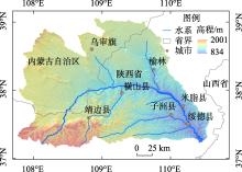
Fig. 1
Location and elevation of the Wuding River Basin"

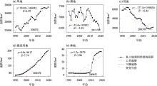
Fig. 2
Area changes of land cover in the Wuding River Basin, 1990-2019"

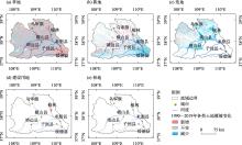
Fig. 3
Changes of land cover in the Wuding River Basin, 1990 -2019"

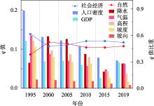
Fig. 4
Factor detection results of land cover spatial differentiation"

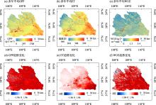
Fig. 5
Changes of GPP, ET and WUE in the Wuding River Basin, 2001-2019"


Fig. 6
Changes in GPP, ET and WUE of the whole and different land cover in the Wuding River Basin, 2001-2019"

| [1] |
Turner B L, Lambin E F, Reenberg A. The emergence of land change science for global environmental change and sustainability[J]. Proceedings of the National Academy of Sciences, 2007, 104(52): 20666-20671.
doi: 10.1073/pnas.0704119104 |
| [2] |
Sterling S M, Ducharne A, Polcher J. The impact of global land-cover change on the terrestrial water cycle[J]. Nature Climate Change, 2013, 3(4): 385-390.
doi: 10.1038/nclimate1690 |
| [3] |
Rindfuss R R, Entwisle B, Walsh S J, et al. Land use change: complexity and comparisons[J]. Journal of Land Use Science, 2008, 3(1): 1-10.
doi: 10.1080/17474230802047955 pmid: 20354590 |
| [4] |
Liu X, Liang X, Li X, et al. A future land use simulation model (FLUS) for simulating multiple land use scenarios by coupling human and natural effects[J]. Landscape and Urban Planning, 2017, 168: 94-116.
doi: 10.1016/j.landurbplan.2017.09.019 |
| [5] |
Li Y, Piao S, Li L Z, et al. Divergent hydrological response to large-scale afforestation and vegetation greening in China[J]. Science Advances, 2018, 4(5): 4182.
doi: 10.1126/sciadv.aar4182 pmid: 29750196 |
| [6] | 刘婉如, 陈春波, 罗格平, 等. 巴尔喀什湖流域土地利用/覆被变化过程与趋势[J]. 干旱区研究, 2021, 38(5): 1452-1463. |
| [Liu Wanru, Chen Chunbo, Luo Geping, et al. Change processes and trends of land use/cover in the Balkhash Lake basin[J]. Arid Zone Research, 2021, 38(5): 1452-1463.] | |
| [7] |
Ren Y J, Lyu Y H, Fu B J, et al. Driving factors of land change in China’s Loess Plateau: Quantification using geographically weighted regression and management implications[J]. Remote Sensing, 2020, 12(3): 453.
doi: 10.3390/rs12030453 |
| [8] | Gohain K J, Mohammad P, Goswami A. Assessing the impact of land use land cover changes on land surface temperature over Pune city, India[J]. Quaternary International, 2021, 575: 259-269. |
| [9] |
Anand V, Oinam B. Future land use land cover prediction with special emphasis on urbanization and wetlands[J]. Remote Sensing Letters, 2020, 11(3): 225-234.
doi: 10.1080/2150704X.2019.1704304 |
| [10] | 王永洵, 王亚飞, 张静文, 等. 海岸带土地利用转型及其生态环境效应——以福建海岸带为例[J]. 环境科学学报, 2021, 41(10): 3927-3937. |
| [Wang Yongxun, Wang Yafei, Zhang Jingwen, et al. Land use transition in coastal zone and its eco-environmental effects: Taking Fujian coastal zone as an example[J]. Acta Scientiae Circumstantiae, 2021, 41(10): 3927-3937.] | |
| [11] |
Chen Y, Wang K, Lin Y, et al. Balancing green and grain trade[J]. Nature Geoscience, 2015, 8(10): 739-741.
doi: 10.1038/ngeo2544 |
| [12] | 李婷, 吕一河, 任艳姣, 等. 黄土高原植被恢复成效及影响因素[J]. 生态学报, 2020, 40(23): 8593-8605. |
| [Li Ting, Lyu Yihe, Ren Yanjiao, et al. Gauging the effectiveness of vegetation restoration and the influence factors in the Loess Plateau[J]. Acta Ecologica Sinica, 2020, 40(23): 8593-8605.] | |
| [13] | 李宗善, 杨磊, 王国梁, 等. 黄土高原水土流失治理现状、问题及对策[J]. 生态学报, 2019, 39(20): 7398-7409. |
| [Li Zongshan, Yang Lei, Wang Guoliang, et al. The management of soil and water conservation in the Loess Plateau of China: Present situations, problems, and counter-solutions[J]. Acta Ecologica Sinica, 2019, 39(20): 7398-7409.] | |
| [14] |
佟彪, 党安荣, 周宏宇. 无定河流域城镇聚落的历史演变与人地耦合[J]. 自然资源学报, 2021, 36(1): 38-54.
doi: 10.31497/zrzyxb.20210103 |
|
[Tong Biao, Dang Anrong, Zhou Hongyu. The historical evolution of urban settlements and man-land coupling in Wuding River Basin[J]. Journal of Natural Resources, 2021, 36(1): 38-54.]
doi: 10.31497/zrzyxb.20210103 |
|
| [15] | 王计平, 程复, 汪亚峰, 等. 生态恢复背景下无定河流域土地利用时空变化[J]. 水土保持通报, 2014, 34(5): 237-243. |
| [Wang Jiping, Cheng Fu, Wang Yafeng, et al. Spatial-temporal changes of land use in wuding river basin under ecological restoration[J]. Bulletin of Soil and Water Conservation, 2014, 34(5): 237-243.] | |
| [16] |
张冉, 王义民, 畅建霞, 等. 基于水资源分区的黄河流域土地利用变化对人类活动的响应[J]. 自然资源学报, 2019, 34(2): 274-287.
doi: 10.31497/zrzyxb.20190205 |
|
[Zhang Ran, Wang Yimin, Chang Jianxia, et al. Response of land use change to human activities in the Yellow River Basin based on water resources division[J]. Journal of Natural Resources, 2019, 34(2): 274-287.]
doi: 10.31497/zrzyxb.20190205 |
|
| [17] | 何航, 张勃, 候启, 等. 1982—2015年中国北方生长季NDVI变化及其对气温极值的响应[J]. 干旱区研究, 2020, 37(1): 244-253. |
| [He Hang, Zhang Bo, Hou Qi, et al. Spatio-temporal change of NDVI and its response to extreme temperature indices in North China from 1982 to 2015[J]. Arid Zone Research, 2020, 37(1): 244-253.] | |
| [18] |
Tian X, Zhao G, Mu X, et al. Hydrologic alteration and possible underlying causes in the Wuding River, China[J]. Science of the Total Environment, 2019, 693: 133556.
doi: 10.1016/j.scitotenv.2019.07.362 |
| [19] |
宁怡楠, 杨晓楠, 孙文义, 等. 黄河中游河龙区间径流量变化趋势及其归因[J]. 自然资源学报, 2021, 36(1): 256-269.
doi: 10.31497/zrzyxb.20210117 |
|
[Ning Yinan, Yang Xiaonan, Sun Wenyi, et al. The trend of runoff change and its attribution in the middle reaches of the Yellow River[J]. Journal of Natural Resources, 2021, 36(1): 256-269.]
doi: 10.31497/zrzyxb.20210117 |
|
| [20] | 蒋凯鑫, 于坤霞, 曹文洪, 等. 黄土高原典型流域水沙变化归因对比分析[J]. 农业工程学报, 2020, 36(4): 143-149. |
| [Jiang Kaixin, Yu Kunxia, Cao Wenhong, et al. Attributional comparative analysis of runoff and sediment change in typical basin of Loess Plateau[J]. Chinese Journal of Agricultural Engineering, 2020, 36(4): 143-149.] | |
| [21] | 陶帅, 邝婷婷, 彭文甫, 等. 2000—2015年长江上游NDVI时空变化及驱动力——以宜宾市为例[J]. 生态学报, 2020, 40(14): 5029-5043. |
| [Tao Shuai, Kuang Tingting, Peng Wenfu, et al. Analyzing the spatio-temporal variation and drivers of NDVI in upper reaches of the Yangtze River from 2000 to 2015: A case study of Yibin City[J]. Acta Ecologica Sinica, 2020, 40(14): 5029-5043.] | |
| [22] | 纪秋磊, 梁伟, 傅伯杰, 等. 基于Google Earth Engine与复杂网络的黄河流域土地利用/覆被变化分析[J]. 生态学报, 2022, 42(6): 2122-2135. |
| [Ji Qiulei, Liang Wei, Fu Bojie, et al. Land use/cover change in the Yellow River Basin based on Google Earth Engine and complex network[J]. Acta Ecologica Sinica, 2022, 42(6): 2122-2135.] | |
| [23] | 闫国振, 张征, 梁康, 等. 鄂尔多斯高原泊江海子流域土地利用动态变化及驱动因素分析[J]. 中国生态农业学报, 2017, 25(11): 1693-1706. |
| [Yan Guozhen, Zhang Zheng, Liang Kang, et al. Characteristics and driving factors of land use change in the Bojiang Lake Basin in Ordos Plateau, China[J]. Chinese Journal of Eco-Agriculture, 2017, 25(11): 1693-1706.] | |
| [24] |
臧玉珠, 刘彦随, 杨园园. 山区县域土地利用格局变化及其地形梯度效应——以井冈山市为例[J]. 自然资源学报, 2019, 34(7): 1391-1404.
doi: 10.31497/zrzyxb.20190704 |
|
[Zang Yuzhu, Liu Yansui, Yang Yuanyuan. Land use pattern change and its topographic gradient effect in the mountainous areas: A case study of Jinggangshan city[J]. Journal of Natural Resources, 2019, 34(7): 1391-1404.]
doi: 10.31497/zrzyxb.20190704 |
|
| [25] |
于元赫, 李子君, 林锦阔, 等. 沂河流域土地利用时空变化图谱特征分析[J]. 自然资源学报, 2019, 34(5): 975-988.
doi: 10.31497/zrzyxb.20190506 |
|
[Yu Yuanhe, Li Zijun, Lin Jinkuo, et al. TUPU characteristics of spatiotemporal variation for the land use in the Yihe River Basin[J]. Journal of Natural Resources, 2019, 34(5): 975-988.]
doi: 10.31497/zrzyxb.20190506 |
|
| [26] |
何春阳, 张金茜, 刘志锋, 等. 1990—2018年土地利用/覆盖变化研究的特征和进展[J]. 地理学报, 2021, 76(11): 2730-2748.
doi: 10.11821/dlxb202111010 |
|
[He Chunyang, Zhang Jinqian, Liu Zhifeng, et al. Characteristics and progress of land use/cover change research during 1990-2018[J]. Acta Geographica Sinica, 2021, 76(11): 2730-2748.]
doi: 10.11821/dlxb202111010 |
|
| [27] |
Berihun M L, Tsunekawa A, Haregeweyn N, et al. Exploring land use/land cover changes, drivers and their implications in contrasting agro-ecological environments of Ethiopia[J]. Land Use Policy, 2019, 87: 104052.
doi: 10.1016/j.landusepol.2019.104052 |
| [28] |
高江波, 焦珂伟, 吴绍洪. 1982—2013年中国植被NDVI空间异质性的气候影响分析[J]. 地理学报, 2019, 74(3): 534-543.
doi: 10.11821/dlxb201903010 |
|
[Gao Jiangbo, Jiao Kewei, Wu Shaohong. Revealing the climatic impacts on spatial heterogeneity of NDVI in China during 1982-2013[J]. Acta Geographica Sinica, 2019, 74(3): 534-543.]
doi: 10.11821/dlxb201903010 |
|
| [29] |
Arowolo A O, Deng X. Land use/land cover change and statistical modelling of cultivated land change drivers in Nigeria[J]. Regional environmental change, 2018, 18(1): 247-259.
doi: 10.1007/s10113-017-1186-5 |
| [30] |
王劲峰, 徐成东. 地理探测器:原理与展望[J]. 地理学报, 2017, 72(1): 116-134.
doi: 10.11821/dlxb201701010 |
|
[Wang Jinfeng, Xu Chengdong. Geodetector: Principle and prospective[J]. Acta Geographica Sinica, 2017, 72(1): 116-134.]
doi: 10.11821/dlxb201701010 |
|
| [31] | 马晓妮, 任宗萍, 谢梦瑶, 等. 基于地理探测器的砒砂岩区植被覆盖度环境驱动因子量化分析[J]. 生态学报, 2022, 42(8): 3389-3399. |
| [Ma Xiaoni, Ren Zongping, Xie Mengyao, et al. Quantitative analysis of environmental driving factors of vegetation coverage in the Pisha sandstone area based on geodetector[J]. Acta Ecologica Sinica, 2022, 42(8): 3389-3399.] | |
| [32] |
韩美, 孔祥伦, 李云龙, 等. 黄河三角洲“三生”用地转型的生态环境效应及其空间分异机制[J]. 地理科学, 2021, 41(6): 1009-1018.
doi: 10.13249/j.cnki.sgs.2021.06.010 |
|
[Han Mei, Kong Xianglun, Li Yunlong, et al. Eco-environmental effects and its spatial heterogeneity of ‘ecological-production-living’ land use transformation in the Yellow River Delta[J]. Scientia Geographica Sinica, 2021, 41(6): 1009-1018.]
doi: 10.13249/j.cnki.sgs.2021.06.010 |
|
| [33] | 韩海青, 王旭红, 牛林芝, 等. 1992—2015年中亚五国LUCC特征及耕地驱动力研究[J]. 中国生态农业学报, 2021, 29(2): 325-339. |
| [Han Haiqing, Wang Xuhong, Niu Linzhi, et al. The land-use and land-cover change characteristics and driving forces of cultivated land in Central Asian countries from 1992 to 2015[J]. Chinese Journal of Eco-Agriculture, 2021, 29(2): 325-339.] | |
| [34] |
Zhang K, Kimball J S, Nemani R R, et al. Vegetation greening and climate change promote multidecadal rises of global land evapotranspiration[J]. Scientific Reports, 2015, 5: 15956.
doi: 10.1038/srep15956 pmid: 26514110 |
| [35] | 姚佳, 陈启慧, 李琼芳, 等. 伊犁河—巴尔喀什湖流域实际蒸散发时空变化特征及其环境影响因子[J]. 干旱区研究, 2022, 39(5): 1564-1575. |
| [Yao Jia, Chen Qihui, Li Qiongfang, et al. Spatial and temporal variability of evapotranspiration and its environmental influencing factors in lli River-Balkhash Lake Basin[J]. Arid Zone Research, 2022, 39(5): 1564-1575.] | |
| [36] |
Monteith J L. Solar radiation and productivity in tropical ecosystems[J]. Journal of Applied Ecology, 1972, 9(3): 747-766.
doi: 10.2307/2401901 |
| [37] |
Guan X, Chen J M, Shen H, et al. Comparison of big-leaf and two-leaf light use efficiency models for GPP simulation after considering a radiation scalar[J]. Agricultural and Forest Meteorology, 2022, 313: 108761.
doi: 10.1016/j.agrformet.2021.108761 |
| [38] | 张世喆, 朱秀芳, 刘婷婷, 等. 气候变化下中国不同植被区GPP对干旱的响应分析[J]. 生态学报, 2022, 42(8): 3429-3440. |
| [Zhang Shizhe, Zhu Xiufang, Liu Tingting, et al. Response of gross primary production to drought under climate change in different vegetation regions of China[J]. Acta Ecologica Sinica, 2022, 42(8): 3429-3440.] | |
| [39] |
To A, Inatomi M. Water-use efficiency of the terrestrial biosphere: A model analysis focusing on interactions between the global carbon and water cycles[J]. Journal of Hydrometeorology, 2012, 13(2): 681-694.
doi: 10.1175/JHM-D-10-05034.1 |
| [40] | 吴方涛, 曹生奎, 曹广超, 等. 高寒湿地生态系统水分利用效率研究[J]. 干旱区研究, 2018, 35(2): 306-314. |
| [Wu Fangtao, Cao Shengkui, Cao Guangchao, et al. Water use Efficiency of Alpine Wetland Ecosystem[J]. Arid Zone Research, 2018, 35(2): 306-314.] | |
| [41] |
张永强, 孔冬冬, 张选泽, 等. 2003—2017年植被变化对全球陆面蒸散发的影响[J]. 地理学报, 2021, 76(3): 584-594.
doi: 10.11821/dlxb202103007 |
|
[Zhang Yongqiang, Kong Dongdong, Zhang Xuanze, et al. Impacts of vegetation changes on global evapotranspiration in the period 2003-2017[J]. Acta Geographica Sinica, 2021, 76(3): 584-594.]
doi: 10.11821/dlxb202103007 |
|
| [42] |
李艳忠, 刘昌明, 刘小莽, 等. 植被恢复工程对黄河中游土地利用/覆被变化的影响[J]. 自然资源学报, 2016, 31(12): 2005-2020.
doi: 10.11849/zrzyxb.20160073 |
|
[Li Yanzhong, Liu Changming, Liu Xiaomang, et al. Impact of the grain for green project on the land use/cover change in the middle Yellow River[J]. Journal of Natural Resources, 2016, 31(12): 2005-2020.]
doi: 10.11849/zrzyxb.20160073 |
|
| [43] | 叶许春, 杨晓霞, 刘福红, 等. 长江流域陆地植被总初级生产力时空变化特征及其气候驱动因子[J]. 生态学报, 2021, 41(17): 6949-6959. |
| [Ye Xuchun, Yang Xiaoxia, Liu Fuhong, et al. Spatio temporal variations of land vegetation gross primary production in the Yangtze River Basin and correlation with meteorological factors[J]. Acta Ecologica Sinica, 2021, 41(17): 6949-6959.] | |
| [44] | Li C, Zhang Y, Shen Y, et al. LUCC-driven changes in gross primary production and actual evapotranspiration in northern China[J]. Journal of Geophysical Research: Atmospheres, 2020, 125(6): e2019JD031705. |
| [45] |
佟彪, 党安荣, 周宏宇. 无定河流域城镇聚落的历史演变与人地耦合[J]. 自然资源学报, 2021, 36(1): 38-54.
doi: 10.31497/zrzyxb.20210103 |
|
[Tong Biao, Dang Anrong, Zhou Hongyu. The historical evolution of urban settlements and man-land coupling in Wuding River Basin[J]. Journal of Natural Resources, 2021, 36(1): 38-54.]
doi: 10.31497/zrzyxb.20210103 |
|
| [46] |
Xu Y, Yu L, Peng D, et al. Annual 30-m land use/land cover maps of China for 1980-2015 from the integration of AVHRR, MODIS and Landsat data using the BFAST algorithm[J]. Science China Earth Science, 2020, 63(9): 1390-1407.
doi: 10.1007/s11430-019-9606-4 |
| [47] | 徐新良. 中国GDP空间分布公里网格数据集[DB/OL]. 中国科学院资源环境科学数据中心数据注册与出版系统, 2017. |
| [Xu Xinliang. Kilometer Grid Dataset of Spatial Distribution of China’s GDP[DB/OL]. Data Registration and Publishing System of Resources and Environment Science and Data Center, Chinese Academy of Sciences, 2017.] | |
| [48] | 徐新良. 中国人口空间分布公里网格数据集[DB/OL]. 中国科学院资源环境科学数据中心数据注册与出版系统, 2017. |
| [Xu Xinliang. Kilometer Grid Dataset of Population Spatial Distribution in China[DB/OL]. Data Registration and Publishing System of Resources and Environment Science and Data Center, Chinese Academy of Sciences, 2017.] | |
| [49] | 张永强, 何韶阳. 中国区域PML-V2陆地蒸散发与总初级生产力数据集(2000.02.26-2020.12.31)[DB/OL]. 国家青藏高原科学数据中心, 2022. |
| [Zhang Yongqiang, He Shaoyang. PML-V2(China): Evapotranspiration and Gross Primary Production (2000. 02.26-2020.12.31)[DB/OL]. National Tibetan Plateau Data Center, 2022.] | |
| [50] | 魏凤英. 现代气候统计诊断与预测技术[M]. 北京: 气象出版社, 1999. |
| [Wei Fengying. Modern Climate Statistical Diagnosis and Prediction Technology[M]. Beijing: Meteorological Press, 1999.] | |
| [51] |
Mann H B. Nonparametric tests against trend[J]. Econometrica: Journal of the Econometric Society, 1945, 13(3): 245-259.
doi: 10.2307/1907187 |
| [52] | Kendall M G. Rank correlation methods[J]. British Journal of Psychology, 1990, 25(1): 86-91. |
| [53] | Pettitt A N. A Non-parametric approach to the change-point problem[J]. Journal of the Royal Statistical Society: Series C (Applied Statistics), 1978, 28(2): 126-135. |
| [54] | 徐成东, 王劲峰, 邢丁凡. 一种基于模拟退火的地理探测器最优离散化方法: CN108959192A[P]. 2018. |
| [Xu Chengdong, Wang Jinfeng, Xing Dingfan. An Optimal Discretization Method for Geographic Detectors Based on Simulated Annealing: CN108959192A[P]. 2018.] | |
| [55] | 朱永华, 罗平平, 郭倩, 等. 毛乌素沙地暖湿化特征分析及其对植被变化的影响[J]. 水土保持学报, 2022, 36(5): 160-172, 180. |
| [Zhu Yonghua, Luo Pingping, Guo Qian, et al. Analysis of warming and humidifying characteristics of Mu Us Sandy Land and its influence on vegetation change[J]. Journal of Soil and Water Conservation, 2022, 36(5): 160-172, 180.] | |
| [56] | 孙福宝. 基于Budyko水热耦合平衡假设的流域蒸散发研究[D]. 北京: 清华大学, 2007. |
| [Sun Fubao. Study on Watershed Evapotranspiration Based on the Budyko Hypothesis[D]. Beijing: Tsinghua University, 2007.] |
|
||