Arid Zone Research ›› 2023, Vol. 40 ›› Issue (11): 1833-1844.doi: 10.13866/j.azr.2023.11.13
• Ecology and Environment • Previous Articles Next Articles
PEI Hongze( ),ZHAO Yachao,ZHANG Tinglong()
Received:2023-06-30
Revised:2023-08-03
Online:2023-11-15
Published:2023-12-01
PEI Hongze, ZHAO Yachao, ZHANG Tinglong. Analysis of spatial and temporal patterns and drivers of local regional NEP in the Loess Plateau from 2000 to 2020[J].Arid Zone Research, 2023, 40(11): 1833-1844.
Add to citation manager EndNote|Reference Manager|ProCite|BibTeX|RefWorks
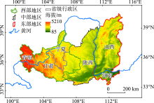
Fig. 1
Range and elevation of the study area"

Tab. 1
Data sources"
| 数据 | 时间 | 分辨率 | 数据来源 |
|---|---|---|---|
| 净初级生产力(NPP) | 2000—2020年 | 500 m | 美国国家航空航天局( |
| 海拔(ALT) | - | 30 m | 地理空间数据云( |
| 年蒸发量(EVP) | 2000年,2010年,2020年 | 1 km | 中国科学院资源环境科学与数据中心( |
| 年平均地温(GST) | 2000年,2010年,2020年 | 1 km | |
| 年平均气压(PRS) | 2000年,2010年,2020年 | 1 km | |
| 年平均相对湿度(RHU) | 2000年,2010年,2020年 | 1 km | |
| 年日照时数(SSD) | 2000年,2010年,2020年 | 1 km | |
| 国内生产总值(GDP) | 2000年,2010年,2019年 | 1 km | |
| 人口密度(PD) | 2000年,2010年,2019年 | 1 km | |
| 年平均风速(WIN) | 2000年,2010年,2020年 | 1 km | |
| 土壤类型(SOT) | 1995年 | 1 km | |
| 年降水量(PRE) | 2000—2020年 | 1 km | 国家地球系统科学数据中心( |
| 年平均气温(TEM) | 2000—2020年 | 1 km | |
| 土地利用/覆盖(LULC) | 2020年 | 30 m | Zenodo( |
| 坡度(SLO) | - | 30 m | DEM坡度分析 |
| 坡向(ALP) | - | 30 m | DEM坡向分析 |
| 与不透水面距离(DFI) | 2020年 | 1 km | LULC提取 |
| 与道路距离(DFR) | 2020年 | 1 km | LULC提取 |
| 与水系距离(DFW) | 2020年 | 1 km | LULC提取 |
| 0~20 cm土壤碳密度(SOC) | 1995年 | - | 国家青藏高原科学数据中心( |
Tab. 2
Interaction types of driving factors"
| 交互类型 | 交互关系 |
|---|---|
| 非线性减弱 | q(X1∩X2)<Min[q(X1),q(X2)] |
| 单因子非线性减弱 | Min[q(X1),q(X2)]<q(X1∩X2)<Max[q(X1), q(X2)] |
| 双因子增强 | q(X1∩X2)>Max[q(X1),q(X2)] |
| 独立 | q(X1∩X2)=q(X1)+q(X2) |
| 非线性增强 | q(X1∩X2)>q(X1)+q(X2) |
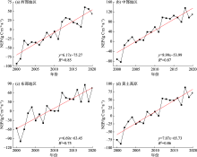
Fig. 2
Annual variation of NEP in Loess Plateau and its sub-regions from 2000 to 2020"


Fig. 3
NEP spatial pattern and carbon source-sink transformation in Loess Plateau from 2000 to 2020"

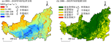
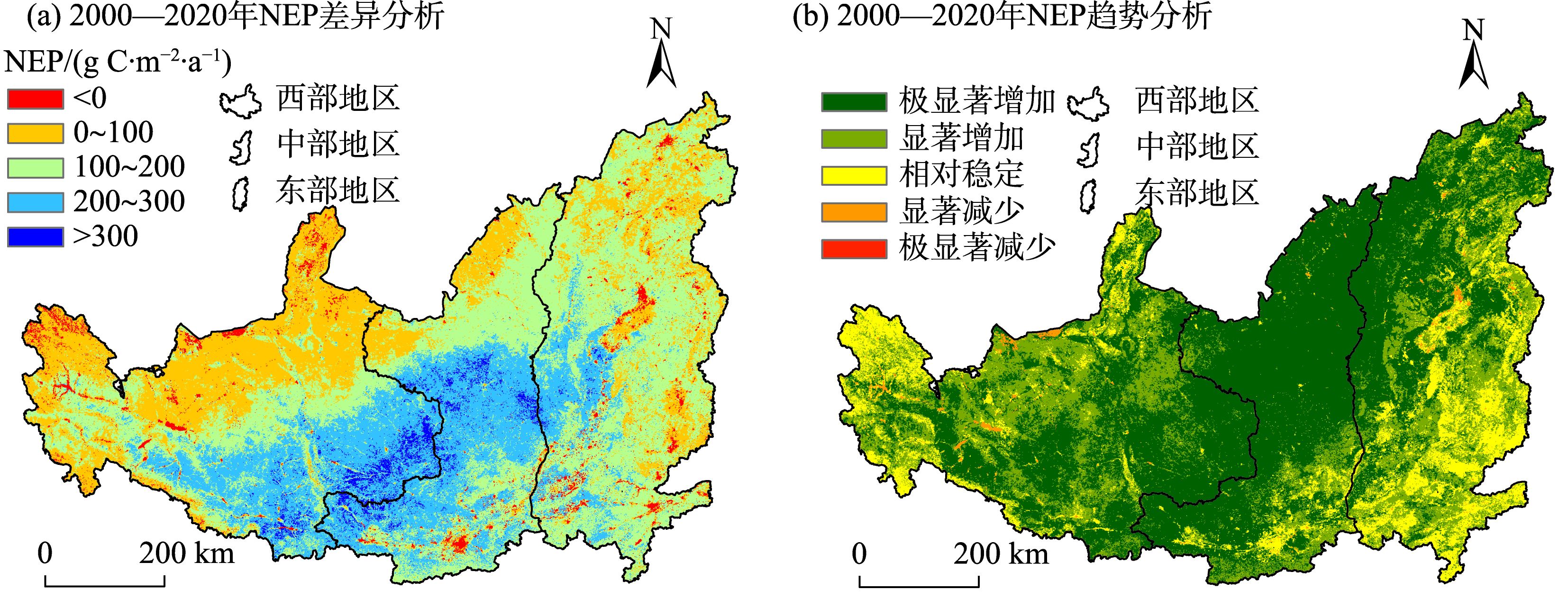
Fig. 4
Difference analysis and trend analysis of NEP from 2000 to 2020"
Tab. 3
Statistics for 2000-2020 trend analysis of NEP"
| 斜率 | |Z|值 | NEP显著性水平 | 百分比/% | |||
|---|---|---|---|---|---|---|
| 西部地区 | 中部地区 | 东部地区 | 研究区 | |||
| <0 | ≥2.58 | 极显著减少 | 0.01 | 0.01 | 0.03 | 0.02 |
| <0 | ≥1.96 | 显著减少 | 1.44 | 0.26 | 0.86 | 0.94 |
| - | <1.96 | 相对稳定 | 12.47 | 4.91 | 22.46 | 14.03 |
| >0 | ≥1.96 | 显著增加 | 35.89 | 14.16 | 34.41 | 29.84 |
| >0 | ≥2.58 | 极显著增加 | 50.18 | 80.67 | 42.24 | 55.17 |
Tab. 4
Statistics for 2000-2020 difference analysis of NEP"
| NEP差异水平 /(g C?m-2?a-1) | 百分比/% | |||
|---|---|---|---|---|
| 西部地区 | 中部地区 | 东部地区 | 研究区 | |
| <0 | 0.81 | 1.82 | 3.70 | 3.21 |
| 0~100 | 86.51 | 13.17 | 22.65 | 26.74 |
| 100~200 | 6.22 | 40.83 | 61.13 | 42.88 |
| 200~300 | 5.71 | 39.85 | 12.14 | 24.60 |
| >300 | 0.75 | 4.33 | 0.38 | 2.57 |
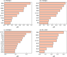
Fig. 5
NEP factor detection results of Loess Plateau and its sub-regions"

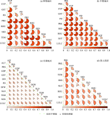
Fig. 6
NEP interaction detection results of Loess Plateau and its sub-regions"

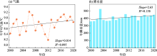
Fig. 7
Temperature and precipitation trends in the Loess Plateau from 2000 to 2020"

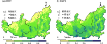
Fig. 8
Spatial pattern of FVC in the Loess Plateau in 2000 and 2020"

| [1] |
Wei X D, Yang J, Luo P P, et al. Assessment of the variation and influencing factors of vegetation NPP and carbon sink capacity under different natural conditions[J]. Ecological Indicators, 2022, 138(22): 108834.
doi: 10.1016/j.ecolind.2022.108834 |
| [2] |
Wang S H, Zhang Y G, Ju W M, et al. Recent global decline of CO2 fertilization effects on vegetation photosynthesis[J]. Science, 2020, 370(6522): 1295-1300.
doi: 10.1126/science.abb7772 |
| [3] | Zhang L, Wylie K B, Ji L, et al. Upscaling carbon fluxes over the Great Plains grasslands: Sinks and sources[J]. Journal of Geophysical Research, 2011, 116(116): G00J03. |
| [4] |
Cui E Q, Bian C Y, Luo Y Q, et al. Spatial variations in terrestrial net ecosystem productivity and its local indicators[J]. Biogeosciences, 2020, 17(23): 6237-6246.
doi: 10.5194/bg-17-6237-2020 |
| [5] |
Keenan T F, Prentice I C, Canadell J G, et al. Recent pause in the growth rate of atmospheric CO2due to enhanced terrestrial carbon uptake[J]. Nature Communications, 2016, 7(1): 13428.
doi: 10.1038/ncomms13428 |
| [6] |
Friedlingstein P, O'Sullivan M, Jones M W, et al. Global carbon budget 2020[J]. Earth System Science Data, 2020, 12(4): 3269-3340.
doi: 10.5194/essd-12-3269-2020 |
| [7] |
Mao F J, Du H Q, Zhou G M, et al. Simulated net ecosystem productivity of subtropical forests and its response to climate change in Zhejiang Province, China[J]. Science of The Total Environment, 2022, 838(51): 155993.
doi: 10.1016/j.scitotenv.2022.155993 |
| [8] |
Wang J, Feng L, Palmer P I, et al. Large Chinese land carbon sink estimated from atmospheric carbon dioxide data[J]. Nature, 2020, 586(7831): 720-723.
doi: 10.1038/s41586-020-2849-9 |
| [9] |
Chen L D, Wang J, Fu B J, et al. Land-use change in a small catchment of northern Loess Plateau, China[J]. Agriculture, Ecosystems & Environment, 2001, 86(2): 163-172.
doi: 10.1016/S0167-8809(00)00271-1 |
| [10] | 张海, 王延平, 高鹏程, 等. 黄土高原坡地土壤干层形成机理及补水途径研究[J]. 水土保持学报, 2003, 17(3): 162-164. |
| [Zhang Hai, Wang Yanping, Gao Pengcheng, et al. Research on mechanism about forming dry layer of slope land and way of supplying water on Loess Plateau[J]. Journal of Soil and Water Conservation, 2003, 17(3): 162-164.] | |
| [11] |
Chen Y P, Wang K B, Lin Y S, et al. Balancing green and grain trade[J]. Nature Geoscience, 2015, 8(10): 739-741.
doi: 10.1038/ngeo2544 |
| [12] | 修丽娜, 颜长珍, 钱大文, 等. 生态工程背景下黄土高原植被变化时空特征及其驱动力[J]. 水土保持通报, 2019, 39(4): 214-221, 228. |
| [Xiu Lina, Yan Changzhen, Qian Dawen, et al. Analysis of spatial-temporal change and driving forces of vegetation in Loess Plateau under background of ecological engineering[J]. Bulletin of Soil and Water Conservation, 2019, 39(4): 214-221, 228.] | |
| [13] | 王一, 郝利娜, 许强, 等. 2001—2019年黄土高原植被覆盖度时空演化特征及地理因子解析[J]. 生态学报, 2023, 43(6): 2397-2407. |
| [Wang Yi, Hao Lina, Xu Qiang, et al. Spatio-temporal variations of vegetation coverage and its geographical factors analysis on the Loess Plateau from 2001 to 2019[J]. Acta Ecologica Sinica, 2023, 43(6): 2397-2407.] | |
| [14] | 刘欢欢, 陈印, 刘悦, 等. 基于随机森林模型的黄土高原草地净初级生产力时空格局及未来演变趋势模拟[J]. 干旱区研究, 2023, 40(1): 123-131. |
| [Liu Huanhuan, Chen Yin, Liu Yue, et al. Simulation of spatial pattern and future trends of grassland net primary productivity in the Loess Plateau based on random forest model[J]. Arid Zone Research, 2023, 40(1): 123-131.] | |
| [15] | 王江涛, 杨永崇, 杨梅焕. 基于地理探测器的黄土高原NPP时空变化及驱动力研究[J]. 西安理工大学学报, 2023, 39(1): 12-20. |
| [Wang Jiangtao, Yang Yongchong, Yang Meihuan. Spatial and temporal variation and driving forces of NPP on the Loess Plateau based on Geodetector[J]. Journal of Xi’an University of Technology, 2023, 39(1): 12-20.] | |
| [16] | 周璐红, 曹瑞超. 黄土高原生境质量时空演变及其驱动因素[J]. 水土保持通报, 2022, 42(6): 343-350. |
| [Zhou Luhong, Cao Ruichao. Spatial-temporal evolution of habitat quality and its influencing factors in Loess Plateau[J]. Bulletin of Soil and Water Conservation, 2022, 42(6): 343-350.] | |
| [17] |
Li Z, Zheng F L, Liu W Z, et al. Spatial distribution and temporal trends of extreme temperature and precipitation events on the Loess Plateau of China during 1961-2007[J]. Quaternary International, 2010, 226(1-2): 92-100.
doi: 10.1016/j.quaint.2010.03.003 |
| [18] | 刘凤, 曾永年. 2000—2015年青海高原植被碳源/汇时空格局及变化[J]. 生态学报, 2021, 41(14): 5792-5803. |
| [Liu Feng, Zeng Yongnian. Analysis of the spatio-temporal variation of vegetation carbon source/sink in Qinghai Plateau from 2000-2015[J]. Acta Ecologica Sinica, 2021, 41(14): 5792-5803.] | |
| [19] |
Zhao J F, Ma J Y, Zhu Y J. Evaluating impacts of climate change on net ecosystem productivity (NEP) of global different forest types based on an individual tree-based model FORCCHN and remote sensing[J]. Global and Planetary Change, 2019, 182(31): 103010.
doi: 10.1016/j.gloplacha.2019.103010 |
| [20] |
Chuai X W, Qi X X, Zhang X Y, et al. Land degradation monitoring using terrestrial ecosystem carbon sinks/sources and their response to climate change in China[J]. Land Degradation & Development, 2018, 29(10): 3489-3502.
doi: 10.1002/ldr.v29.10 |
| [21] |
Yu G R, Zheng Z M, Wang Q F, et al. Spatiotemporal pattern of soil respiration of terrestrial ecosystems in China: The development of a geostatistical model and its simulation[J]. Environmental Science & Technology, 2010, 44(16): 6074-6080.
doi: 10.1021/es100979s |
| [22] | Zhang Y, Zhang C B, Wang Z Q, et al. Vegetation dynamics and its driving forces from climate change and human activities in the Three-River Source Region, China from 1982 to 2012[J]. Science of The Total Environment, 2016, 563- 564(45): 210-220. |
| [23] |
Zhang J J, Hao X M, Hao H C, et al. Climate change decreased net ecosystem productivity in the arid region of central Asia[J]. Remote Sensing, 2021, 13(21): 4449.
doi: 10.3390/rs13214449 |
| [24] |
Wang C, Zhao W Z, Zhang Y Y. The change in net ecosystem productivity and its driving mechanism in a mountain ecosystem of arid regions, Northwest China[J]. Remote Sensing, 2022, 14(16): 4046.
doi: 10.3390/rs14164046 |
| [25] |
Wang J F, Zhang T L, Fu B J. A measure of spatial stratified heterogeneity[J]. Ecological Indicators, 2016, 67: 250-256.
doi: 10.1016/j.ecolind.2016.02.052 |
| [26] |
王劲峰, 徐成东. 地理探测器: 原理与展望[J]. 地理学报, 2017, 72(1): 116-134.
doi: 10.11821/dlxb201701010 |
|
[Wang Jinfeng, Xu Chengdong. Geodetector: Principle and prospective[J]. Acta Geographica Sinica, 2017, 72(1): 116-134.]
doi: 10.11821/dlxb201701010 |
|
| [27] |
Zhang D N, Zhao Y H, Wu J S. Assessment of carbon balance attribution and carbon storage potential in China’s terrestrial ecosystem[J]. Resources Conservation and Recycling, 2023, 189(36): 106748.
doi: 10.1016/j.resconrec.2022.106748 |
| [28] |
Ye X, Chuai X. Carbon sinks/sources’ spatiotemporal evolution in China and its response to built-up land expansion[J]. Journal of Environmental Management, 2022, 321(50): 115863.
doi: 10.1016/j.jenvman.2022.115863 |
| [29] | Sun W Y, Song X Y, Mu X M, et al. Spatiotemporal vegetation cover variations associated with climate change and ecological restoration in the Loess Plateau[J]. Agricultural and Forest Meteorology, 2015, 209- 210(52): 87-99. |
| [30] | 王兵. 黄土丘陵区流域生态恢复环境响应及其评价[D]. 北京: 中国科学院大学, 2011. |
| [Wang Bing. Environmental Response and Assessment of Watershed Ecological Restoration in Loess Hilly Region[D]. Beijing: University of Chinese Academy of Sciences, 2011.] | |
| [31] | 韩磊, 杨梅丽, 刘钊, 等. 黄土高原典型退耕区生态系统服务权衡与协同关系研究——以延安市为例[J]. 生态学报, 2022, 42(20): 8115-8125. |
| [Han Lei, Yang Meili, Liu Zhao, et al. Ecosystem service tradeoffs and synergies in typical farmland conversion area of the Loess Plateau: Taking Yan’an city as an example[J]. Acta Ecologica Sinica, 2022, 42(20): 8115-8125.] | |
| [32] |
张子龙, 鹿晨昱, 陈兴鹏, 等. 陇东黄土高原农业生态效率的时空演变分析——以庆阳市为例[J]. 地理科学, 2014, 34(4): 472-478.
doi: 10.13249/j.cnki.sgs.2014.04.472 |
|
[Zhang Zilong, Lu Chenyu, Chen Xingpeng, et al. Spatio-temporal evolution of agricultural eco-efficiency in Loess Plateau of east Gansu Province: A case study of Qingyang City[J]. Scientia Geographica Sinica, 2014, 34(4): 472-478.]
doi: 10.13249/j.cnki.sgs.2014.04.472 |
|
| [33] | 毛盛林, 上官周平. 近20年黄土高原土地利用/植被覆盖变化特征及其成因[J]. 水土保持研究, 2022, 29(5): 213-219. |
| [Mao Shenglin, Shangguan Zhouping. Characteristics and causes of land use/vegetation coverage of the Loess Plateau in the past 20 years[J]. Research of Soil and Water Conservation, 2022, 29(5): 213-219.] | |
| [34] |
Oishi A C, Miniat C F, Novick K A, et al. Warmer temperatures reduce net carbon uptake, but do not affect water use, in a mature southern Appalachian forest[J]. Agricultural and Forest Meteorology, 2018, 252(55): 269-282.
doi: 10.1016/j.agrformet.2018.01.011 |
| [35] |
Wang M M, Zhao J, Wang S Q, et al. Detection and attribution of positive net ecosystem productivity extremes in China’s terrestrial ecosystems during 2000-2016[J]. Ecological Indicators, 2021, 132(21): 108323.
doi: 10.1016/j.ecolind.2021.108323 |
| [36] |
Fang X, Zhang C, Wang Q, et al. Isolating and quantifying the effects of climate and CO2 changes (1980-2014) on the net primary productivity in arid and semiarid China[J]. Forests, 2017, 8(3): 60.
doi: 10.3390/f8030060 |
| [37] |
Yang H F, Zhong X N, Deng S Q, et al. Assessment of the impact of LUCC on NPP and its influencing factors in the Yangtze River basin, China[J]. Catena, 2021, 206(49): 105542.
doi: 10.1016/j.catena.2021.105542 |
| [38] |
Brown S, Lugo A E. Trailblazing the carbon cycle of tropical forests from Puerto Rico[J]. Forests, 2017, 8(4): 101.
doi: 10.3390/f8040101 |
| [39] |
Baccini A, Walker W, Carvalho L, et al. Tropical forests are a net carbon source based on aboveground measurements of gain and loss[J]. Science, 2017, 358(6360): 230-234.
doi: 10.1126/science.aam5962 pmid: 28971966 |
|
||