Arid Zone Research ›› 2024, Vol. 41 ›› Issue (2): 230-239.doi: 10.13866/j.azr.2024.02.06
• Land and Water Resources • Previous Articles Next Articles
XU Ning1( ), LI Zhiguo1(), LIANG Xueyue2, ZHOU Xiaoying1
Received:2023-06-09
Revised:2023-11-06
Online:2024-02-15
Published:2024-03-11
XU Ning, LI Zhiguo, LIANG Xueyue, ZHOU Xiaoying. Distribution pattern and causes of glaciers in the Tibetan Plateau based on terrain gradient[J].Arid Zone Research, 2024, 41(2): 230-239.
Add to citation manager EndNote|Reference Manager|ProCite|BibTeX|RefWorks

Fig. 1
Distribution map of relative elevation difference of Tibetan Plateau"

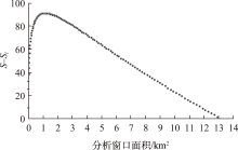
Fig. 2
Scatter plot of S-Si variation range under different window areas"

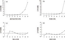
Fig. 3
The distribution characteristics of glaciers with different topographic factors"
Tab. 1
Influence of topographic factors on glacier distribution"
| 因子探测q值 | 交互探测 | ||||||||||
|---|---|---|---|---|---|---|---|---|---|---|---|
| 海拔 | 地形起 伏度 | 坡度 | 坡向 | 海拔∩坡向 | 海拔∩坡度 | 坡向∩坡度 | 海拔∩地形起伏度 | 坡向∩地形起伏度 | 海拔∩地形起伏度 | ||
| 阿尔金山 | 0.5901 | 0.3296 | 0.0158 | 0.0172 | 0.6651 | 0.6258 | 0.1082 | 0.6221 | 0.4106 | 0.4834 | |
| 祁连山 | 0.5205 | 0.2006 | 0.0046 | 0.0123 | 0.5480 | 0.5359 | 0.0343 | 0.5596 | 0.2277 | 0.2792 | |
| 唐古拉山 | 0.4717 | 0.2658 | 0.0017 | 0.0028 | 0.4794 | 0.5236 | 0.0162 | 0.6128 | 0.2770 | 0.4488 | |
| 昆仑山 | 0.4346 | 0.2242 | 0.0128 | 0.0070 | 0.4498 | 0.4756 | 0.0252 | 0.4610 | 0.2397 | 0.4007 | |
| 兴都库什山 | 0.3885 | 0.2045 | 0.0454 | 0.0108 | 0.4077 | 0.4451 | 0.0657 | 0.4326 | 0.2216 | 0.2951 | |
| 帕米尔 | 0.3445 | 0.2319 | 0.0279 | 0.0105 | 0.3632 | 0.3920 | 0.0448 | 0.3815 | 0.2496 | 0.3109 | |
| 横断山 | 0.2400 | 0.1328 | 0.0152 | 0.0056 | 0.2507 | 0.2631 | 0.0342 | 0.2829 | 0.1511 | 0.1865 | |
| 羌塘高原 | 0.1851 | 0.2220 | 0.0093 | 0.0044 | 0.1920 | 0.2568 | 0.0237 | 0.2428 | 0.2325 | 0.3218 | |
| 喜马拉雅山 | 0.1720 | 0.1256 | 0.0422 | 0.0039 | 0.1768 | 0.2115 | 0.0485 | 0.2150 | 0.1330 | 0.1979 | |
| 喀喇昆仑山 | 0.1593 | 0.1508 | 0.0475 | 0.0053 | 0.1668 | 0.2475 | 0.0564 | 0.2493 | 0.1612 | 0.2520 | |
| 念青唐古拉山 | 0.1201 | 0.0915 | 0.0202 | 0.0028 | 0.1258 | 0.1556 | 0.0290 | 0.1733 | 0.0989 | 0.1357 | |
| 冈底斯山 | 0.0673 | 0.0992 | 0.0119 | 0.0019 | 0.0698 | 0.0811 | 0.0286 | 0.1170 | 0.1082 | 0.1213 | |
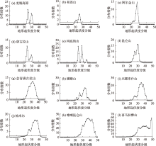
Fig. 4
Distribution map of mountain glaciers based on RDLS"

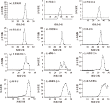
Fig. 5
The distribution of glaciers in each mountain range on the elevation gradient"

| [1] |
刘时银, 姚晓军, 郭万钦, 等. 基于第二次冰川编目的中国冰川现状[J]. 地理学报, 2015, 70(1): 3-16.
doi: 10.11821/dlxb201501001 |
|
[Liu Shiyin, Yao Xiaojun, Guo Wanqin, et al. The contemporary glaciers in China based on the Second Chinese Glacier Inventory[J]. Acta Geographica Sinica, 2015, 70(1): 3-16.]
doi: 10.11821/dlxb201501001 |
|
| [2] | 姚檀栋, 陈发虎, 崔鹏, 等. 从青藏高原到第三极和泛第三极[J]. 中国科学院院刊, 2017, 32(9): 924-931. |
| [Yao Tandong, Chen Fahu, Cui Peng, et al. From Tibetan Plateau to Third Pole and Pan-Third Pole[J]. China Academic Journal Electronic Publishing House, 2017, 32(9): 924-931.] | |
| [3] |
Yao T D, Wu F Y, Ding L, et al. Multispherical interactions and their effects on the Tibetan Plateau’s earth system: A review of the recent researches[J]. National Science Review, 2015, 2(4): 468-488.
doi: 10.1093/nsr/nwv070 |
| [4] |
冀琴, 董军, 刘睿, 等. 1990—2015年喜马拉雅山冰川变化的遥感监测及动因分析[J]. 地理科学, 2020, 40(3): 486-496.
doi: 10.13249/j.cnki.sgs.2020.03.017 |
|
[Ji Qin, Dong Jun, Liu Rui, et al. Glacier changes in response to climate change in the Himalayas in 1990-2015[J]. Scientia Geographica Sinica, 2020, 40(3): 486-496.]
doi: 10.13249/j.cnki.sgs.2020.03.017 |
|
| [5] | 施雅风. 中国冰川与环境:现在、过去和未来[M]. 北京: 科学出版社, 2000. |
| [Shi Yafeng. Glaciers and Their Environments in China: The Present, Past and Future[M]. Beijing: Science Press, 2000.] | |
| [6] | 孙永, 易朝路, 刘金花, 等. 昆仑山木孜塔格地区冰川发育水汽来源探讨[J]. 地球环境学报, 2018, 9(4): 383-391. |
| [Sun Yong, Yi Chaolu, Liu Jinhua, et al. Discussing sources of moisture feeding the glaciers on the Ulugh Muztagh, Kunlun Mountain[J]. Journal of Earth Environment, 2018, 9(4): 383-391.] | |
| [7] |
吴坤鹏, 刘时银, 郭万钦. 1980—2015年南迦巴瓦峰地区冰川变化及其对气候变化的响应[J]. 冰川冻土, 2020, 42(4): 1115-1125.
doi: 10.7522/j.issn.1000-0240.2020.0098 |
|
[Wu Kunpeng, Liu Shiyin, Guo Wanqin. Glacier variation and its response to climate change in the Mount Namjagbarwa from 1980 to 2015[J]. Journal of Glaciology and Geocryology, 2020, 42(4): 1115-1125.]
doi: 10.7522/j.issn.1000-0240.2020.0098 |
|
| [8] |
王盛, 姚檀栋, 蒲健辰. 祁连山七一冰川物质平衡的时空变化特征[J]. 自然资源学报, 2020, 35(2): 399-412.
doi: 10.31497/zrzyxb.20200212 |
|
[Wang Sheng, Yao Tandong, Pu Jianchen. Spatial and temporal variations in mass balance of Qiyi Glacier in Qilian Mountains[J]. Journal of Natural Resources, 2020, 35(2): 399-412.]
doi: 10.31497/zrzyxb.20200212 |
|
| [9] |
Wang R J, Ding Y J, Shangguan D H, et al. Influence of topographic shading on the mass balance of the high mountain Asia glaciers[J]. Remote Sensing, 2022, 14(7): 1576.
doi: 10.3390/rs14071576 |
| [10] |
张正勇, 刘琳, 徐丽萍. 冰川分布格局对地理因子响应机制[J]. 生态环境学报, 2018, 27(2): 290-296.
doi: 10.16258/j.cnki.1674-5906.2018.02.013 |
| [Zhang Zhengyong, Liu Lin, Xu Liping. Response mechanism of glacial distribution patterns to geographical factors[J]. Ecology and Environmental Sciences, 2018, 27(2): 290-296.] | |
| [11] |
张鲜鹤, 王欣, 刘时银, 等. 基于第二次冰川编目数据的中国冰川高度结构特征分析[J]. 地理学报, 2017, 72(3): 397-406.
doi: 10.11821/dlxb201703003 |
|
[Zhang Xianhe, Wang Xin, Liu Shiyin, et al. Altitude structure characteristics of the glaciers in China based on the Second Chinese Glacier Inventory[J]. Acta Geographica Sinica, 2017, 72(3): 397-406.]
doi: 10.11821/dlxb201703003 |
|
| [12] | 周远刚, 赵锐锋, 张丽华, 等. 博格达峰地区冰川和积雪变化遥感监测及影响因素分析[J]. 干旱区地理, 2019, 42(6): 169-177. |
| [Zhou Yuangang, Zhao Ruifeng, Zhang Lihua, et al. Remote sensing monitoring of the change of glacier and snow cover and its influencing factors in Mount Bogda[J]. Arid Land Geography, 2019, 42(6): 169-177.] | |
| [13] | 黄丹妮, 张震, 张莎莎, 等. 东帕米尔高原冰川运动特征分析[J]. 干旱区地理, 2021, 44(1): 131-140. |
| [Huang Danni, Zhang Zhen, Zhang Shasha, et al. Characteristics of glacier movement in the eastern Pamir Plateau[J]. Arid Land Geography, 2021, 44(1): 131-140.] | |
| [14] | 张廉卿, 许向科, 张骞, 等. 念青唐古拉山西段小冰期以来冰川变化[J]. 地球环境学报, 2019, 10(6): 567-578. |
| [Zhang Lianqin, Xu Xiangke, Zhang Qian, et al. Glacier change in the western Nyainqentanglha Range, southern Tibet, since the Little Ice Age[J]. Journal of Earth Environment, 2019, 10(6): 567-578.] | |
| [15] |
李林凤, 李开明. 石羊河流域冰川变化与地形因子的关系探究[J]. 冰川冻土, 2019, 41(5): 1026-1035.
doi: 10.7522/j.issn.1000-0240.2019.0533 |
|
[Li Linfeng, Li Kaiming. Study on the relationship between glacier change and topographic factors in the Shiyang River Basin[J]. Journal of Glaciology and Geocryology, 2019, 41(5): 1026-1035.]
doi: 10.7522/j.issn.1000-0240.2019.0533 |
|
| [16] |
封志明, 李文君, 李鹏, 等. 青藏高原地形起伏度及其地理意义[J]. 地理学报, 2020, 75(7): 1359-1372.
doi: 10.11821/dlxb202007003 |
|
[Feng Zhiming, Li Wenjun, Li Peng, et al. Relief degree of land surface and its geographical meanings in the Qinghai-Tibet Plateau, China[J]. Acta Geographica Sinica, 2020, 75(7): 1359-1372.]
doi: 10.11821/dlxb202007003 |
|
| [17] |
王劲峰, 徐成东. 地理探测器:原理与展望[J]. 地理学报, 2017, 72(1): 116-134.
doi: 10.11821/dlxb201701010 |
|
[Wang Jinfeng, Xu Chengdong. Geodetector: Principle and prospective[J]. Acta Geographica Sinica, 2017, 72(1): 116-134.]
doi: 10.11821/dlxb201701010 |
|
| [18] |
Zhang G Q, Yao T D, Xie H J, et al. Increased mass over the Tibetan Plateau: From lakes or glaciers?[J]. Geophysical Research Letters, 2013, 40(10): 2125-2130.
doi: 10.1002/grl.v40.10 |
| [19] | RGI Consortium. Randolph Glacier Inventory: A Dataset of Global Glacier Outlines, Version 6[DB/OL]. Boulder, Colorado USA: National Snow and Ice Data Center, 2017. |
| [20] |
牟建新, 李忠勤, 张慧, 等. 全球冰川面积现状及近期变化—基于2017年发布的第6版Randolph冰川编目[J]. 冰川冻土, 2018, 40(2): 238-248.
doi: 10.7522/j.issn.1000-0240.2018.0028 |
|
[Mu Jianxin, Li Zhongqin, Zhang Hui, et al. The global glacierized area: Current situation and recent change, based on the Randolph Glacier Inventory(RGI 6.0) published in 2017[J]. Journal of Glaciology and Geocryology, 2018, 40(2): 238-248.]
doi: 10.7522/j.issn.1000-0240.2018.0028 |
|
| [21] |
Guo W Q, Liu S Y, Xu L, et al. The second Chinese glacier inventory: Data, methods and results[J]. Journal of Glaciology, 2015, 61(226): 357-372.
doi: 10.3189/2015JoG14J209 |
| [22] |
Mölg N, Bolch T, Rastner P, et al. A consistent glacier inventory for Karakoram and Pamir derived from landsat data: Distribution of debris cover and mapping challenges[J]. Earth System Science Data, 2018, 10(4): 1807-1827.
doi: 10.5194/essd-10-1807-2018 |
| [23] |
Uuemaa E, Ahi S, Montibeller B, et al. Vertical accuracy of freely available global digital elevation models (ASTER, AW3D30, MERIT, TanDEM-X, SRTM, and NASADEM)[J]. Remote Sensing, 2020, 12(21): 3482.
doi: 10.3390/rs12213482 |
| [24] |
宿星, 魏万鸿, 郭万钦, 等. 基于SRTM DEM的地形起伏度对天水市黄土滑坡的影响分析[J]. 冰川冻土, 2017, 39(3): 616-622.
doi: 10.7522/j.issn.1000-0240.2017.0069 |
|
[Su Xing, Wei Wanhong, Guo Wanqin, et al. Analyzing the impact of relief amplitude to loess landslides based on SRTM DEM in Tianshui Prefecture[J]. Journal of Glaciology and Geocryology, 2017, 39(3): 616-622.]
doi: 10.7522/j.issn.1000-0240.2017.0069 |
|
| [25] | 喻红, 曾辉, 江子瀛. 快速城市化地区景观组分在地形梯度上的分布特征研究[J]. 地理科学, 2001, 21(1): 64-69. |
|
[Yu Hong, Zeng Hui, Jiang Ziying. Study on distribution characteristics of landscape elements along the terrain gradient[J]. Scientia Geographica Sinica, 2001, 21(1): 64-69.]
doi: 10.13249/j.cnki.sgs.2001.01.64 |
|
| [26] |
Zhu M L, Yao T D, Yang W, et al. Differences in mass balance behavior for three glaciers from different climatic regions on the Tibetan Plateau[J]. Climate Dynamics, 2018, 50: 3457-3484.
doi: 10.1007/s00382-017-3817-4 |
| [27] | Huang L X, Chen J, Yang K, et al. The northern boundary of the Asian summer monsoon and division of westerlies and monsoon regimes over the Tibetan Plateau in present-day[J]. Science China(Earth Sciences), 2023, 66(4): 882-893. |
| [28] |
杨勤业, 郑度. 冈底斯山-念青唐古拉山线自然地理意义的探讨[J]. 地理研究, 1985, 4(2): 36-44.
doi: 10.11821/yj1985020005 |
|
[Yang Qinye, Zheng Du. On the significance of the boundary line-the Gandisi-Nyainqentanglha Range[J]. Geographical Research, 1985, 4(2): 36-44.]
doi: 10.11821/yj1985020005 |
|
||