Arid Zone Research ›› 2024, Vol. 41 ›› Issue (4): 590-602.doi: 10.13866/j.azr.2024.04.06
• Land and Water Resources • Previous Articles Next Articles
LI Wenxiu1( ), YAN Zhengang2()
Received:2023-09-21
Revised:2023-12-15
Online:2024-04-15
Published:2024-04-26
LI Wenxiu, YAN Zhengang. Analysis of spatiotemporal evolution of land use and its driving mechanism in the agro-pastoral ecotone of Gansu Province using Geodetector[J].Arid Zone Research, 2024, 41(4): 590-602.
Add to citation manager EndNote|Reference Manager|ProCite|BibTeX|RefWorks
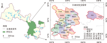
Fig. 1
Location of study area"

Tab. 1
Detection of interaction"
| 判据 | 交互作用 |
|---|---|
| q(x1∩x2)<min[q(x1),q(x2)] | 非线性减弱 |
| min[q(x1),q(x2)]<q(x1∩x2)<max[q(x1),q(x2)] | 单因子非线性减弱 |
| q(x1∩x2)>max[q(x1),q(x2)] | 双因子增强 |
| q(x1∩x2)=q(x1)+q(x2) | 独立 |
| q(x1∩x2)>q(x1)+q(x2) | 非线性增强 |
Tab. 2
Driving factors and description of land-use change"
| 因素 | 因子 | 单位 | 说明(以2015—2020年为例) |
|---|---|---|---|
| 自然地理 | 高程(x1) | m | 由分辨率为30 m的DEM数据提取 |
| 坡度(x2) | ° | 由分辨率为30 m的DEM数据计算 | |
| 坡向(x3) | - | 由分辨率为30 m的DEM数据计算 | |
| 降水量(x4) | mm | 2020年和2015年年平均降水量的差值 | |
| 社会经济 | 人口密度(x5) | 人·hm-2 | 2020年和2015年人口密度的差值 |
| 城镇人口比重(x6) | % | 2020年和2015年城镇人口比重的差值 | |
| 地区生产总值(x7) | 104元 | 2020年和2015年地区生产总值的差值 | |
| 固定资产投资(x8) | 104元 | 2020年和2015年固定资产投资的差值 | |
| 路网密度(x9) | km·km-2 | 2020年和2015年路网密度的差值 |
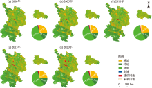
Fig. 2
Land-use type in agro-pastoral transitional zone of Gansu"


Fig. 3
Comparison map of each land-use dynamic index during 2000 to 2020"
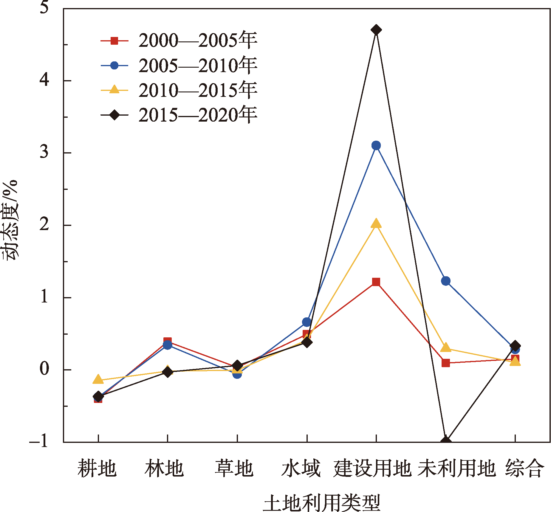

Fig. 4
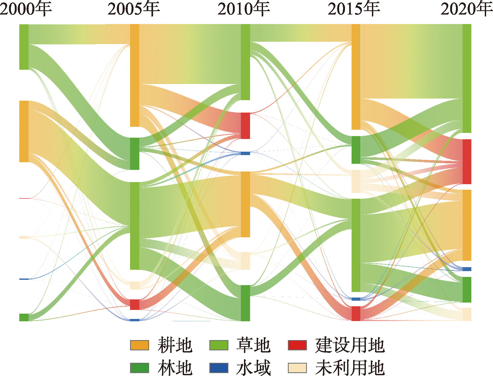
Land-use transfer Sankey map in agro-pastoral transitional zone of Gansu during 2000 to 2020"
Tab. 3
Change rates of major land-use change types in agro-pastoral transitional zone of Gansu during 2000 to 2020 /%"
| 土地利用变化类型 | 耕地→林地 | 耕地→草地 | 耕地→建设用地 | 林地→草地 | 草地→耕地 | 草地→林地 | 草地→建设用地 |
|---|---|---|---|---|---|---|---|
| 2000—2005年 | 0.11 | 0.55 | 0.07 | 0.07 | 0.25 | 0.29 | 0.01 |
| 2005—2010年 | 0.16 | 0.76 | 0.26 | 0.12 | 0.64 | 0.28 | 0.05 |
| 2010—2015年 | 0.02 | 0.24 | 0.15 | 0.11 | 0.23 | 0.11 | 0.02 |
| 2015—2020年 | 0.06 | 0.70 | 0.29 | 0.27 | 0.50 | 0.24 | 0.21 |
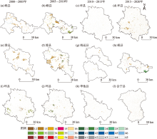
Fig. 5
Geo-spectrum of land-use change in key areas of agro-pastoral transitional zone of Gansu during 2000 to 2020"

Tab. 4
Land-use degree index in agro-pastoral transitional zone of Gansu during 2000 to 2020"
| 土地利用类型 | 土地利用程度等级 | 土地利用程度指数 | ||||
|---|---|---|---|---|---|---|
| 2000年 | 2005年 | 2010年 | 2015年 | 2020年 | ||
| 耕地 | 3 | 75.36 | 73.85 | 72.46 | 71.94 | 70.62 |
| 林地 | 2 | 31.51 | 32.13 | 32.68 | 32.65 | 32.61 |
| 草地 | 2 | 110.46 | 110.65 | 110.32 | 110.30 | 110.64 |
| 水域 | 2 | 1.17 | 1.19 | 1.23 | 1.26 | 1.28 |
| 建设用地 | 4 | 4.96 | 5.26 | 6.07 | 6.68 | 8.25 |
| 未利用地 | 1 | 2.07 | 2.08 | 2.21 | 2.24 | 2.13 |
| 合计 | 225.52 | 225.16 | 224.98 | 225.08 | 225.54 | |
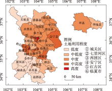
Fig. 6
Land-use degree map in agro-pastoral transitional zone of Gansu in 2020"

Tab. 5
Factor detector of land-use change in agro-pastoral transitional zone of Gansu"
| 驱动因子 | 2000—2005年 | 2005—2010年 | 2010—2015年 | 2015—2020年 | |||||||
|---|---|---|---|---|---|---|---|---|---|---|---|
| q值 | P值 | q值 | P值 | q值 | P值 | q值 | P值 | ||||
| x1 | 0.273 | 0 | 0.037 | 0 | 0.117 | 0 | 0.339 | 0 | |||
| x2 | 0.033 | 0 | 0.037 | 0 | 0.026 | 0.004 | 0.043 | 0 | |||
| x3 | 0.003 | 0.945 | 0.007 | 0.541 | 0.004 | 0.861 | 0.009 | 0.325 | |||
| x4 | 0.226 | 0 | 0.266 | 0 | 0.177 | 0 | 0.316 | 0 | |||
| x5 | 0.112 | 0 | 0.059 | 0.126 | 0.292 | 0 | 0.087 | 0 | |||
| x6 | 0.190 | 0 | 0.134 | 0 | 0.143 | 0 | 0.149 | 0 | |||
| x7 | 0.112 | 0 | 0.124 | 0 | 0.108 | 0 | 0.400 | 0 | |||
| x8 | 0.355 | 0 | 0.363 | 0 | 0.291 | 0 | 0.174 | 0 | |||
| x9 | 0.263 | 0 | 0.188 | 0 | 0.249 | 0 | 0.202 | 0 | |||
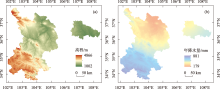
Fig. 7
Elevation and precipitation analysis chart in agro-pastoral transitional zone of Gansu in 2020"


Fig. 8
Interaction detector and Ecological detector of land-use chang in agro-pastoral transitional zone of Gansu"

| [1] | 李云霞, 王晨旭, 刘焱序. 基于生态系统服务簇分区的土地利用多目标优化——以巴彦淖尔市为例[J]. 生态学杂志, 2023, 42(5): 1205-1213. |
|
[Li Yunxia, Wang Chenxu, Liu Yanxu. Multi-objective optimization of land use based on ecosystem service bundle zoning: A case study of Bayannur City[J]. Chinese Journal of Ecology, 2023, 42(5): 1205-1213.]
doi: DOI: 10.13292/j.1000-4890.202305.020 |
|
| [2] | 郭健斌, 张英, 张志伟, 等. 基于地理探测器的藏东南高山峡谷区土地利用变化及其驱动机制——以西藏林芝市为例[J]. 中国农业大学学报, 2023, 28(4): 210-226. |
| [Guo Jianbin, Zhang Ying, Zhang Zhiwei, et al. Land use change and its driving mechanism in the alpine gorge of Southeast Tibet based in geodetector: A case study of Nyingchi City[J]. Journal of China Agricultural University, 2023, 28(4): 210-226.] | |
| [3] | 徐谅慧, 杨磊, 李加林, 等. 基于GIS-Logistic耦合模型的杭州湾南岸景观演变驱动力分析[J]. 应用海洋学学报, 2016, 35(1): 75-86. |
| [Xu Lianghui, Yang Lei, Li Jialin, et al. Analysis on the driving force of landscape evolvement of Hangzhou Bay based on GIS-Logistic coupling model[J]. Journal of Applied Oceanography, 2016, 35(1): 75-86.] | |
| [4] | 樊舒迪, 刘振华, 朱明帮, 等. 基于地理探测器的广州市土地利用时序变化及影响因素[J]. 西南农业学报, 2022, 35(10): 2276-2289. |
| [Fan Shudi, Liu Zhenhua, Zhu Mingbang, et al. Time series change and influencing factors of land use in Guangzhou City based on geodetector[J]. Southwest China Journal of Agricultural Sciences, 2022, 35(10): 2276-2289.] | |
| [5] |
杨爱民, 朱磊, 陈署晃, 等. 1975—2015年玛纳斯河流域土地利用变化的地学信息图谱分析[J]. 应用生态学报, 2019, 30(11): 3863-3874.
doi: 10.13287/j.1001-9332.201911.017 |
|
[Yang Aimin, Zhu Lei, Chen Shuhuang, et al. Geo-informatic spectrum analysis of land use change in the Manas River Basin, China during 1975-2015[J]. Chinese Journal of Applied Ecology, 2019, 30(11): 3863-3874.]
doi: 10.13287/j.1001-9332.201911.017 |
|
| [6] |
Bao Chao, Xu Mutian, Sun Siao. China’s land uses in the multi-region input-output framework[J]. International Journal of Environmental Research and Public Health, 2019, 16(16): 2940-2940.
doi: 10.3390/ijerph16162940 |
| [7] |
Cerrillo N M R, Rodríguez P G, Rumbao C I, et al. Modeling major rural land-use changes using the GIS-based cellular automata metronamica model: The case of Andalusia (Southern Spain)[J]. ISPRS International Journal of Geo-Information, 2020, 9(7): 458-472.
doi: 10.3390/ijgi9070458 |
| [8] | 葛茹香, 马超. 干旱高原湖泊湿地土地利用变化与驱动因素分析——以泊江海子湿地闭流区为例[J]. 水土保持研究, 2022, 29(1): 376-385. |
| [Ge Ruxiang, Ma Chao. Analysis on land use change and driving factors of lake wetland in arid plateau—A case study on the Inflow Area of Bojianghaizi Wetland[J]. Research of Soil and Water Conservation, 2022, 29(1): 376-385.] | |
| [9] |
王劲峰, 徐成东. 地理探测器:原理与展望[J]. 地理学报, 2017, 72(1): 116-134.
doi: 10.11821/dlxb201701010 |
|
[Wang Jinfeng, Xu Chengdong. Geodetector: Principle and prospective[J]. Acta Geographica Sinica, 2017, 72(1): 116-134.]
doi: 10.11821/dlxb201701010 |
|
| [10] |
丁悦, 蔡建明, 任周鹏, 等. 基于地理探测器的国家级经济技术开发区经济增长率空间分异及影响因素[J]. 地理科学进展, 2014, 33(5): 657-666.
doi: 10.11820/dlkxjz.2014.05.007 |
|
[Ding Yue, Cai Jianming, Ren Zhoupeng, et al. Spatial disparities of economic growth rate of China’s national-level ETDZs and their determinants based on geographical detector analysis[J]. Progress in Geography, 2014, 33(5): 657-666.]
doi: 10.11820/dlkxjz.2014.05.007 |
|
| [11] |
刘彦随, 李进涛. 中国县域农村贫困化分异机制的地理探测与优化决策[J]. 地理学报, 2017, 72(1): 161-173.
doi: 10.11821/dlxb201701013 |
|
[Liu Yansui, Li Jintao. Geographic detection and optimizing decision of the differentiation mechanism of rural poverty in China[J]. Acta Geographica Sinica, 2017, 72(1): 161-173.]
doi: 10.11821/dlxb201701013 |
|
| [12] | 中华人民共和国国务院. 全国国土规划纲要(2016—2030年)[EB/OL]. (2017-01-03)[2023-06-29]. https://landchina.mnr.gov.cn/tdgh1/201702/t20170205_6818302.html. |
| [ State Council of the People’s Republic of China. Outline of the National Land Plan (2016-2030)[EB/OL]. (2017-01-03)[2023-06-29]. https://landchina.mnr.gov.cn/tdgh1/201702/t20170205_6818302.html. ] | |
| [13] | 李洁, 赵锐锋, 谢作轮. 甘肃省区域社会—生态系统脆弱性综合评价[J]. 经济地理, 2015, 35(12): 168-175. |
| [Li Jie, Zhao Ruifeng, Xie Zuolun. The comprehensive assessment of vulnerability in social-ecological system of Gansu Province[J]. Economic Geography, 2015, 35(12): 168-175.] | |
| [14] |
梁赟亮, 李杰, 陆燕花, 等. 基于LUCC的甘肃省农牧交错带生态系统服务价值评估及时空演变特征研究[J]. 草业学报, 2023, 32(5): 13-26.
doi: 10.11686/cyxb2022232 |
|
[Liang Yunliang, Li Jie, Lu Yanhua, et al. Ecosystem service value evaluation and temporal-spatial evolution characteristics in an agro-pastoral ecotone of Gansu Province based on LUCC[J]. Acta Prataculturae Sinica, 2023, 32(5): 13-26.]
doi: 10.11686/cyxb2022232 |
|
| [15] | 陈全功. 再谈“胡焕庸线”及农牧交错带[J]. 草业科学, 2018, 35(3): 669-676. |
| [Chen Quangong. “Hu Population Line” and the transitional border between agriculture and pasture: A discussion from a new perspective[J]. Pratacultural Science, 2018, 35(3): 669-676.] | |
| [16] | 彭守璋. 中国1 km分辨率逐月降水量数据集(1901-2022)[EB/OL]. 时空三极环境大数据平台, 2020. https://doi.org/10.5281/zenodo.3185722. |
| [Peng Shouzhang. 1 km Monthly Precipitation Dataset for China (1901-2022)[EB/OL]. A Big Earth Data Platform for Three Poles, 2020. https://doi.org/10.5281/zenodo.3185722.] | |
| [17] |
Baum-Snow N, Brandt L, Henderson V J, et al. Roads, railroads, and decentralization of Chinese cities[J]. Review of Economics and Statistics, 2017, 99(3): 435-448.
doi: 10.1162/REST_a_00660 |
| [18] | 《中国县域统计年鉴2021(县市卷)》编辑委员会, 王明华. 中国县域统计年鉴[M]. 北京: 中国统计出版社, 2021. |
| [ China County Statistical Yearbook 2021(County Volume) Editorial Committee, Wang Minghua. China County Statistical Yearbook[M]. Beijing: China Statistics Press, 2021.] | |
| [19] | 杨德伟, 张云红, 王道杰, 等. 岷江上游土地利用的时空分异[J]. 山地学报, 2009, 27(5): 579-584. |
| [Yang Dewei, Zhang Yunhong, Wang Daojie, et al. Spatio-temporal variation of land use changes in the upper reaches of Minjiang River[J]. Journal of Mountain Science, 2009, 27(5): 579-584.] | |
| [20] | 王彦武, 高金芳, 陈爱华, 等. 关川河流域土地利用变化对其生态服务价值的影响[J]. 山东农业科学, 2023, 55(4): 163-172. |
| [Wang Yanwu, Gao Jinfang, Chen Aihua, et al. Effects of land use change on its ecological service value in Guanchuan River Basin[J]. Shandong Agricultural Sciences, 2023, 55(4): 163-172.] | |
| [21] | 任利广, 马维伟, 李广, 等. 基于GIS的甘肃省农牧交错带土地沙化敏感性时空分布格局[J]. 干旱区资源与环境, 2022, 36(6): 149-156. |
| [Ren Liguang, Ma Weiwei, Li Guang, et al. Temporal and spatial distribution pattern of land desertification sensitivity in agro pastoral ecotone of Gansu Province[J]. Journal of Arid Land Resources and Environment, 2022, 36(6): 163-172.] | |
| [22] |
Zhang Siliang, Guan Zilong, Liu Yan, et al. Land use/cover change and its relationship with regional development in Xixian New Area, China[J]. Sustainability, 2022, 14(11): 6889.
doi: 10.3390/su14116889 |
| [23] | 李毅, 肖腊梅, 胡文敏, 等. 长株潭核心区土地利用变化时空格局及驱动力多维分析[J]. 经济地理, 2021, 41(7): 173-182. |
| [Li Yi, Xiao Lamei, Hu Wenmin, et al. Spatio-temporal pattern of land use change in Changsha-Zhuzhou-Xiangtan Core Areas and its driving forces[J]. Economic Geography, 2021, 41(7): 173-182.] |
|
||