Arid Zone Research ›› 2024, Vol. 41 ›› Issue (7): 1140-1152.doi: 10.13866/j.azr.2024.07.06
• Land and Water Resources • Previous Articles Next Articles
GAO Pengcheng1( ), YUE Yanni1(), YAN Jixuan1, WANG Shijie2,3,4, BIE Qiang2,3,4
Received:2024-03-25
Revised:2024-05-09
Online:2024-07-15
Published:2024-08-01
GAO Pengcheng, YUE Yanni, YAN Jixuan, WANG Shijie, BIE Qiang. Spatio-temporal evolution and driving factors of land use and ecological risk in Gannan Tibetan Autonomous Prefecture[J].Arid Zone Research, 2024, 41(7): 1140-1152.
Add to citation manager EndNote|Reference Manager|ProCite|BibTeX|RefWorks
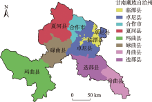
Fig. 1
Overview of the study area"

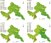
Fig. 2
Spatial distribution of land use in 1990, 2000, 2010 and 2020"

Tab. 1
Area and proportion of land use types in Gannan Tibetan Autonomous Prefecture"
| 1990年 | 2000年 | 2010年 | 2020年 | ||||||||
|---|---|---|---|---|---|---|---|---|---|---|---|
| 面积/km2 | 占比/% | 面积/km2 | 占比/% | 面积/km2 | 占比/% | 面积/km2 | 占比/% | ||||
| 耕地 | 1469.24 | 4.01 | 1693.11 | 4.62 | 1630.66 | 4.45 | 2420.87 | 6.60 | |||
| 林地 | 11330.05 | 30.90 | 11205.92 | 30.56 | 11233.88 | 30.64 | 13108.49 | 35.75 | |||
| 草地 | 20888.43 | 56.97 | 20790.19 | 56.71 | 20752.41 | 56.60 | 19436.44 | 53.01 | |||
| 水体 | 221.84 | 0.61 | 210.96 | 0.58 | 272.81 | 0.74 | 409.64 | 1.12 | |||
| 建设用地 | 97.69 | 0.27 | 106.62 | 0.29 | 143.25 | 0.39 | 168.70 | 0.46 | |||
| 未利用地 | 2655.95 | 7.24 | 2656.40 | 7.25 | 2630.19 | 7.17 | 1119.06 | 3.05 | |||
| 合计 | 36663.19 | 1.00 | 36663.19 | 1.00 | 36663.19 | 1.00 | 36663.19 | 1.00 | |||
Tab. 2
Dynamic attitude, contribution rate and intensity of land use change in Gannan Tibetan Autonomous Prefecture"
| 1990—2000年 | 2000—2010年 | 2010—2020年 | |||||||||
|---|---|---|---|---|---|---|---|---|---|---|---|
| 动态度/% | 贡献率/% | 强度/% | 动态度/% | 贡献率/% | 强度/% | 动态度/% | 贡献率/% | 强度/% | |||
| 耕地 | 1.52 | 47.99 | 0.61 | -0.37 | 24.69 | -0.17 | 4.85 | 13.98 | 2.15 | ||
| 林地 | -0.11 | 26.61 | -0.34 | 0.02 | 11.06 | 0.08 | 1.67 | 33.15 | 5.11 | ||
| 草地 | -0.05 | 21.06 | 0.26 | -0.02 | 14.94 | 0.11 | -0.63 | 23.27 | -3.59 | ||
| 水体 | -0.49 | 2.33 | -0.03 | 2.93 | 24.46 | 0.16 | 5.02 | 2.42 | 0.38 | ||
| 建设用地 | 0.91 | 1.91 | 0.03 | 3.44 | 14.48 | 0.10 | 1.78 | 0.45 | 0.07 | ||
| 未利用地 | 0.00 | 0.10 | 0.01 | -0.10 | 10.37 | -0.08 | -5.75 | 26.73 | -4.12 | ||
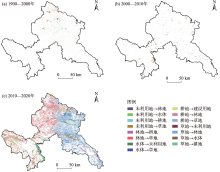
Fig. 3
Land use type transfer from 1990 to 2000, 2000 to 2010 and 2010 to 2020"

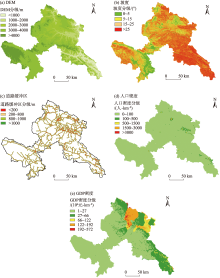
Fig. 4
Classification of DEM, slope, distance from road, population density and GDP density in Gannan Tibetan Autonomous Prefecture"

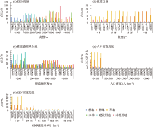
Fig. 5
Land use types in different grades of driving factors in Gannan Tibetan Autonomous Prefecture"
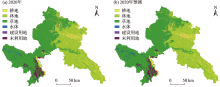
Fig. 6
Current situation and prediction of land use in 2020 in Gannan Tibetan Autonomous Prefecture"

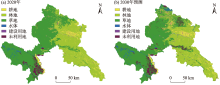
Fig. 7
Current situation of land use in 2020 and prediction of land use in 2030 in Gannan Tibetan Autonomous Prefecture"

Tab. 3
Current land use in 2020 and projected area in 2030"
| 土地利用类型 | 2020年 | 2030年 | 变化 幅度/% | |||
|---|---|---|---|---|---|---|
| 现状面积/km2 | 占比/% | 预测面积/km2 | 占比/% | |||
| 耕地 | 2420.29 | 6.60 | 2815.65 | 7.68 | 16.34 | |
| 林地 | 13102.49 | 35.75 | 12807.25 | 34.95 | -2.25 | |
| 草地 | 19429.69 | 53.02 | 19352.89 | 52.81 | -0.40 | |
| 水体 | 407.33 | 1.11 | 472.90 | 1.29 | 16.10 | |
| 建设用地 | 168.69 | 0.46 | 234.63 | 0.64 | 39.09 | |
| 未利用地 | 1118.19 | 3.05 | 963.43 | 2.63 | -13.84 | |
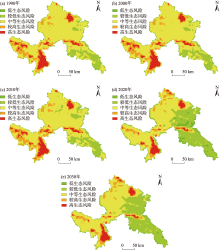
Fig. 8
Ecological risk classification of 1990 to 2030 in Gannan Tibetan Autonomous Prefecture"

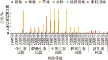
Fig. 9
Land use types in different grades of ecological risk in Gannan Tibetan Autonomous Prefecture"

| [1] | 李钊, 安放舟, 张永福, 等. 喀什市生态系统服务价值对土地利用变化的响应及预测[J]. 水土保持通报, 2015, 35(5): 274-278. |
| [Li Zhao, An Fangzhou, Zhang Yongfu, et al. Prediction of ecosystem services value and its response to land use change in Kashi City[J]. Bulletin of Soil and Water Conservation, 2015, 35(5): 274-278.] | |
| [2] |
刘毅. 论中国人地关系演进的新时代特征——“中国人地关系研究”专辑序言[J]. 地理研究, 2018, 37(8): 1477-1484.
doi: 10.11821/dlyj201808001 |
|
[Liu Yi. Preface to the special issue on Chinese man-land relationships in a new era[J]. Geographical Research, 2018, 37(8): 1477-1484.]
doi: 10.11821/dlyj201808001 |
|
| [3] | 郭健斌, 张英, 张志伟, 等. 基于地理探测器的藏东南高山峡谷区土地利用变化及其驱动机制——以西藏林芝市为例[J]. 中国农业大学学报, 2023, 28(4): 210-226. |
| [Guo Jianbin, Zhang Ying, Zhang Zhiwei, et al. Land use change and its driving mechanism in the alpine gorge of southeast Tibet based on geodetector: A case study of Nyingchi City[J]. Journal of China Agricultural University, 2023, 28(4): 210-226.] | |
| [4] | 王鹏, 秦思彤, 胡慧蓉. 近30 a拉萨河流域土地利用变化和生境质量的时空演变特征[J]. 干旱区研究, 2023, 40(3): 492-503. |
| [Wang Peng, Qin Sitong, Hu Huirong. Spatial-temporal evolution characteristics of land use change and habitat quality in the Lhasa River Basin over the past three decades[J]. Arid Zone Research, 2023, 40(3): 492-503.] | |
| [5] | 张炳智, 张丽, 张继贤. 利用遥感技术进行全球测图项目中的中国土地利用覆盖和植被分类图的制作[J]. 测绘科学, 2002, 27(1): 42-46. |
| [Zhang Bingzhi, Zhang Li, Zhang Jixian. Produce landuse & landcover and vegetation data of global mapping by the remote sensing technology[J]. Science of Surveying and Mapping, 2002, 27(1): 42-46.] | |
| [6] | 王兵, 臧玲. 我国土地利用/土地覆被变化研究近期进展[J]. 地域研究与开发, 2006, 25(2): 86-91. |
| [Wang Bing, Zang Ling. Recent progress of studies on land use and land cover change in China[J]. Areal Research and Development, 2006, 25(2): 86-91.] | |
| [7] | 周广金, 吴连喜. 近30年巢湖流域土地利用变化及其驱动力研究[J]. 东华理工大学学报(自然科学版), 2009, 32(3): 265-270. |
| [Zhou Guangjin, Wu Lianxi. Land use change and its driver factor in Chaohu Lake Basin[J]. Journal of East China Institute of Technology, 2009, 32(3): 265-270.] | |
| [8] | 王海军, 孔祥冬, 张勃. 空间统计模型在土地利用与覆被变化模拟与预测中的应用——以Logistic-CA-Markov模型为例[J]. 科学技术与工程, 2016, 16(15): 139-143. |
| [Wang Haijun, Kong Xiangdong, Zhang Bo. Application of spatial statistical model in LUCC simulation and forecast: Taking the Logistic-CA-Markov Model as an example[J]. Science Technology and Engineering, 2016, 16(15): 139-143.] | |
| [9] | 许月卿, 田媛, 孙丕苓. 基于Logistic回归模型的张家口市土地利用变化驱动力及建设用地增加空间模拟研究[J]. 北京大学学报(自然科学版), 2015, 51(5): 955-964. |
| [Xu Yueqing, Tian Yuan, Sun Piling. Study on driving forces and spatial simulation of land use change in Zhangjiakou City based on Logistic Regression Model[J]. Acta Scientiarum Naturalium Universitatis Pekinensis, 2015, 51(5): 955-964.] | |
| [10] | 吴桂平. 不同尺度转换方式对土地利用格局模拟的影响效应研究[J]. 水土保持研究, 2010, 17(5): 75-79. |
| [Wu Guiping. Exploring effect of different scaling methods on simulation of land use patterns[J]. Research of Soil and Water Conservation, 2010, 17(5): 75-79.] | |
| [11] | 乔治, 蒋玉颖, 贺曈, 等. 土地利用变化模拟研究进展[J]. 生态学报, 2022, 42(13): 5165-5176. |
| [Qiao Zhi, Jiang Yuying, He Tong, et al. Land use change simulation: Progress, challenges, and prospects[J]. Acta Ecologica Sinica, 2022, 42(13): 5165-5176.] | |
| [12] | Zhao G W. Effects of spatial scale in Cellular Automata model for land use change[J]. Lecture Notes in Electrical Engineering, 2013, 156(1): 101-106. |
| [13] | 朱磊, 夏鑫鑫, 杨爱民, 等. 玛纳斯河流域绿洲区耕地扩张的CA-Markov模型参数敏感性分析[J]. 干旱区研究, 2020, 37(5): 1327-1336. |
| [Zhu Lei, Xia Xinxin, Yang Aimin. et al. Expansion of cultivated land in the oasis area of the Manas River basin sensitivity analysis of CA-Markov model parameters[J]. Arid Zone Research, 2020, 37(5): 1327-1336.] | |
| [14] | 王功文, 陈建平, 丁火平. 基于CA模型的北京及邻区土地荒漠化动态演化评价[J]. 地学前缘, 2004, 11(2): 378. |
| [Wang Gongwen, Chen Jianping, Ding Huoping. Dynamic evolution assessment of land desertification in Beijing and its neighboring areas based on CA Model[J]. Earth Science Frontiers, 2004, 11(2): 378.] | |
| [15] |
王建兵, 安华银, 汪治桂, 等. 甘南高原秋季连阴雨的气候特征及主要环流形势[J]. 干旱气象, 2013, 31(1): 70-77.
doi: 10. 11755 /j. issn. 1006 - 7639( 2013) - 01 - 0070 |
| [Wang Jianbing, An Huayin, Wang Zhigui, et al. The climatic characteristics of continuous autumn rain in Gannan Plateau during 1981-2010 and the main circulation[J]. Journal of Arid Meteorology, 2013, 31(1): 70-77.] | |
| [16] | 谢花林. 基于景观结构和空间统计学的区域生态风险分析[J]. 生态学报, 2008, 28(10): 5020-5026. |
| [Xie Hualin. Regional eco-risk analysis of based on landscape structure and spatial statistics[J]. Acta Ecologica Sinica, 2008, 28(10): 5020-5026.] | |
| [17] | 陈心怡, 谢跟踪, 张金萍. 海口市海岸带近30年土地利用变化的景观生态风险评价[J]. 生态学报, 2021, 41(3): 975-986. |
| [Chen Xinyi, Xie Genzong, Zhang Jinping. Landscape ecological risk assessment of land use changes in the coastal area of Haikou City in the past 30 years[J]. Acta Ecologica Sinica, 2021, 41(3): 975-986.] | |
| [18] |
张学斌, 石培基, 罗君, 等. 基于景观格局的干旱内陆河流域生态风险分析——以石羊河流域为例[J]. 自然资源学报, 2014, 29(3): 410-419.
doi: 10.11849/zrzyxb.2014.03.005 |
|
[Zhang Xuebin, Shi Peiji, Luo Jun, et al. The ecological risk assessment of Arid Inland River at the landscape scale: A case study on Shiyang River Basin[J]. Journal of Natural Resources, 2014, 29(3): 410-419.]
doi: 10.11849/zrzyxb.2014.03.005 |
|
| [19] | 赵雨琪, 魏天兴. 1990—2020年黄土高原典型县域植被覆盖变化及影响因素[J]. 干旱区研究, 2024, 41(1): 147-156. |
| [Zhao Yuqi, Wei Tianxing. Changes in vegetation cover and influencing factors in typical counties of the Loess Plateau from 1990 to 2020[J]. Arid Zone Research, 2024, 41(1): 147-156.] | |
| [20] | 孙智斌, 高敏华, 崔雪锋. 基于遥感与GIS的天山北坡经济带2000—2015年土地利用动态变化研究[J]. 北京师范大学学报(自然科学版), 2018, 54(3): 397-404. |
| [Sun Zhibin, Gao Minhua, Cui Xuefeng. Land use change in north slope economic zone of Tianshan Mountain based on remote sensing and GIS from 2000-2015[J]. Journal of Beijing Normal University (Natural Science), 2018, 54(3): 397-404.] | |
| [21] | 韩盼. 西部大开发以来甘南藏族自治州经济发展探析[J]. 赤峰学院学报(自然科学版), 2015, 31(3): 205-207. |
| [Han Pan. Analysis on the economic development of Gannan Tibetan Autonomous Prefecture since the development of western China[J]. Journal of Chifeng University (Natural Science Edition), 2015, 31(3): 205-207.] | |
| [22] | Ma Q A, Liu W. Consistency evaluation of the current distribution of short-circuit tests in AT feeding systems for high-speed railways[J]. Journal of Modern Transportation, 2018, 26(3): 163-172. |
| [23] | 陈宏芳, 高永, 党晓宏. 基于CA-Markov模型的库布齐沙漠土地利用变化预测研究[J]. 内蒙古林业科技, 2022, 48(2): 18-22. |
| [Chen Hongfang, Gao Yong, Dang Xiaohong. Prediction of land use change in Kubuqi Desert based on CA-Markov Model[J]. Journal of Inner Mongolia Forestry & Technology, 2022, 48(2): 18-22.] | |
| [24] |
吴晓旭, 邹学勇. 基于遥感与GIS的乌审旗土地利用变化研究[J]. 地理科学进展, 2009, 28(2): 199-206.
doi: 10.11820/dlkxjz.2009.02.006 |
|
[Wu Xiaoxu, Zou Xueyong. Research on land use change of Uxin Qi[J]. Progress in Geography, 2009, 28(2): 199-206.]
doi: 10.11820/dlkxjz.2009.02.006 |
|
||