Arid Zone Research ›› 2024, Vol. 41 ›› Issue (8): 1331-1342.doi: 10.13866/j.azr.2024.08.07
• Land and Water Resources • Previous Articles Next Articles
QIU Chunxia1( ), LIU Xiaohong1, LI Dou1, ZHANG Jiamiao2, LI Pengfei1()
Received:2023-10-09
Revised:2024-05-18
Online:2024-08-15
Published:2024-08-22
Contact:
LI Pengfei
E-mail:000358@xust.edu.cn;pengfeili@xust.edu.cn
QIU Chunxia, LIU Xiaohong, LI Dou, ZHANG Jiamiao, LI Pengfei. Application of airborne LiDAR with fuzzy inference system in soil erosion monitoring on the Loess Plateau[J].Arid Zone Research, 2024, 41(8): 1331-1342.
Add to citation manager EndNote|Reference Manager|ProCite|BibTeX|RefWorks
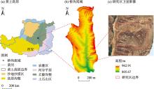
Fig. 1
Study area profile"

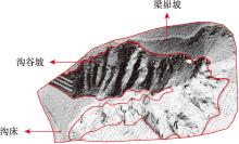
Fig. 2
Geomorphic unit division"

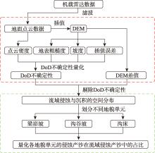
Fig. 3
Technical route"
Tab. 1
Four-input fuzzy inference system ruleset for DEM elevation uncertainty error"
| 规则 | 输入 | 输出 | 规则 | 输入 | 输出 | ||||||||
|---|---|---|---|---|---|---|---|---|---|---|---|---|---|
| 地表 粗糙度/m | 坡度/(°) | 点云密度 /(Pts·m-2) | 插值 误差/m | 高程不确定 性误差/m | 地表 粗糙度/m | 坡度/(°) | 点云密度 /(Pts·m-2) | 插值 误差/m | 高程不确定性误差/m | ||||
| 1 | 低 | 低 | 高 | 空 | 低 | 16 | 低 | 高 | 中 | 空 | 中 | ||
| 2 | 中 | 低 | 高 | 空 | 低 | 17 | 中 | 高 | 中 | 空 | 高 | ||
| 3 | 高 | 低 | 高 | 空 | 低 | 18 | 高 | 高 | 中 | 空 | 高 | ||
| 4 | 低 | 中 | 高 | 空 | 低 | 19 | 低 | 低 | 低 | 空 | 高 | ||
| 5 | 中 | 中 | 高 | 空 | 低 | 20 | 中 | 低 | 低 | 空 | 高 | ||
| 6 | 高 | 中 | 高 | 空 | 中 | 21 | 高 | 低 | 低 | 空 | 极端值 | ||
| 7 | 低 | 高 | 高 | 空 | 低 | 22 | 低 | 中 | 低 | 空 | 高 | ||
| 8 | 中 | 高 | 高 | 空 | 中 | 23 | 中 | 中 | 低 | 空 | 高 | ||
| 9 | 高 | 高 | 高 | 空 | 中 | 24 | 高 | 中 | 低 | 空 | 极端值 | ||
| 10 | 低 | 低 | 中 | 空 | 低 | 25 | 低 | 高 | 低 | 空 | 极端值 | ||
| 11 | 中 | 低 | 中 | 空 | 中 | 26 | 中 | 高 | 低 | 空 | 极端值 | ||
| 12 | 高 | 低 | 中 | 空 | 中 | 27 | 高 | 高 | 低 | 空 | 极端值 | ||
| 13 | 低 | 中 | 中 | 空 | 中 | 28 | 极端值 | 空 | 空 | 空 | 极端值 | ||
| 14 | 中 | 中 | 中 | 空 | 中 | 29 | 空 | 空 | 空 | 高 | 极端值 | ||
| 15 | 高 | 中 | 中 | 空 | 高 | ||||||||
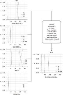
Fig. 4
Fuzzy inference system input and output membership functions"
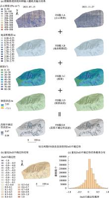
Fig. 5
DoD uncertainty results quantified in the study area and their probability distribution"

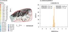
Fig. 6
Spatial distribution map of erosion and deposition of the hillslope and elevation variation area statistics(2021-07-15—11-27)"
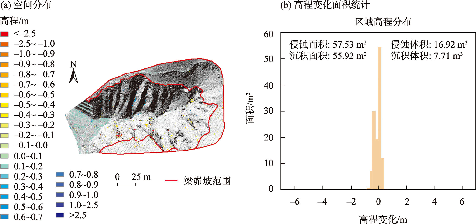

Fig. 7
Spatial distribution map of erosion and deposition of the gully slope and elevation variation area statistics(2021-07-15—11-27)"
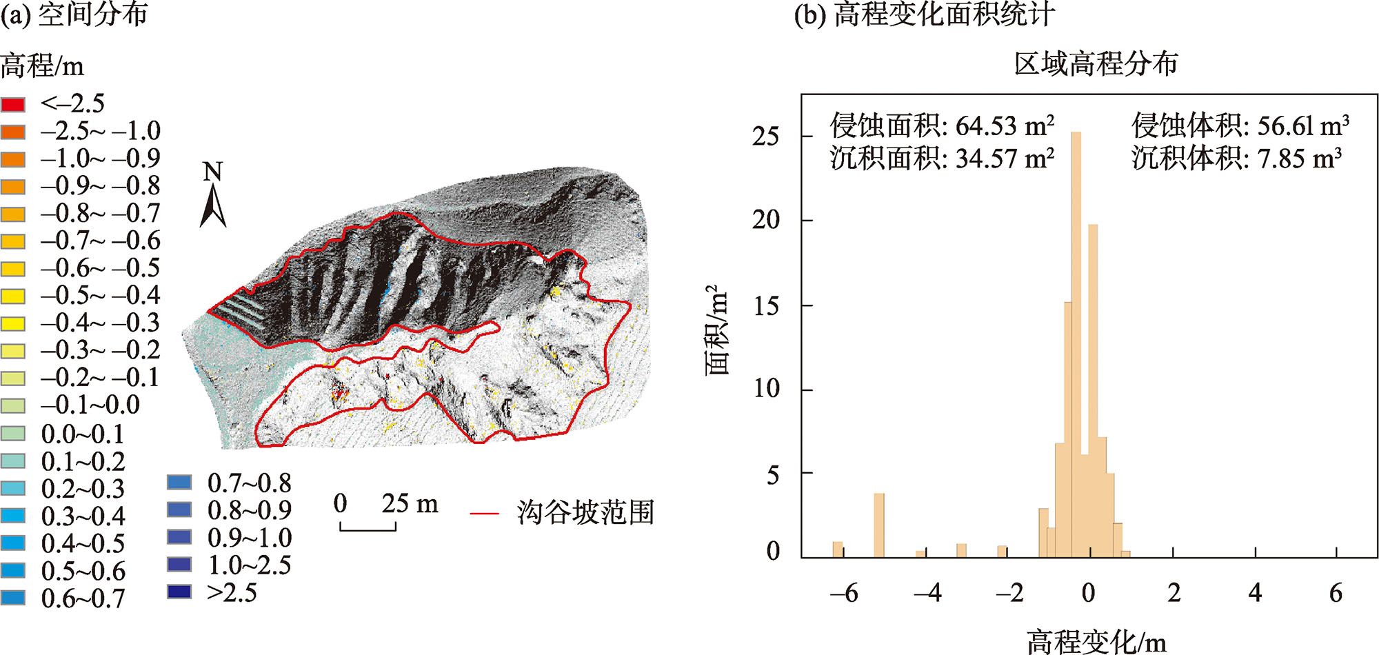
Fig. 8
Spatial distribution map of erosion and deposition of the bottom of the gully and elevation variation area statistics(2021-07-15—11-27)"
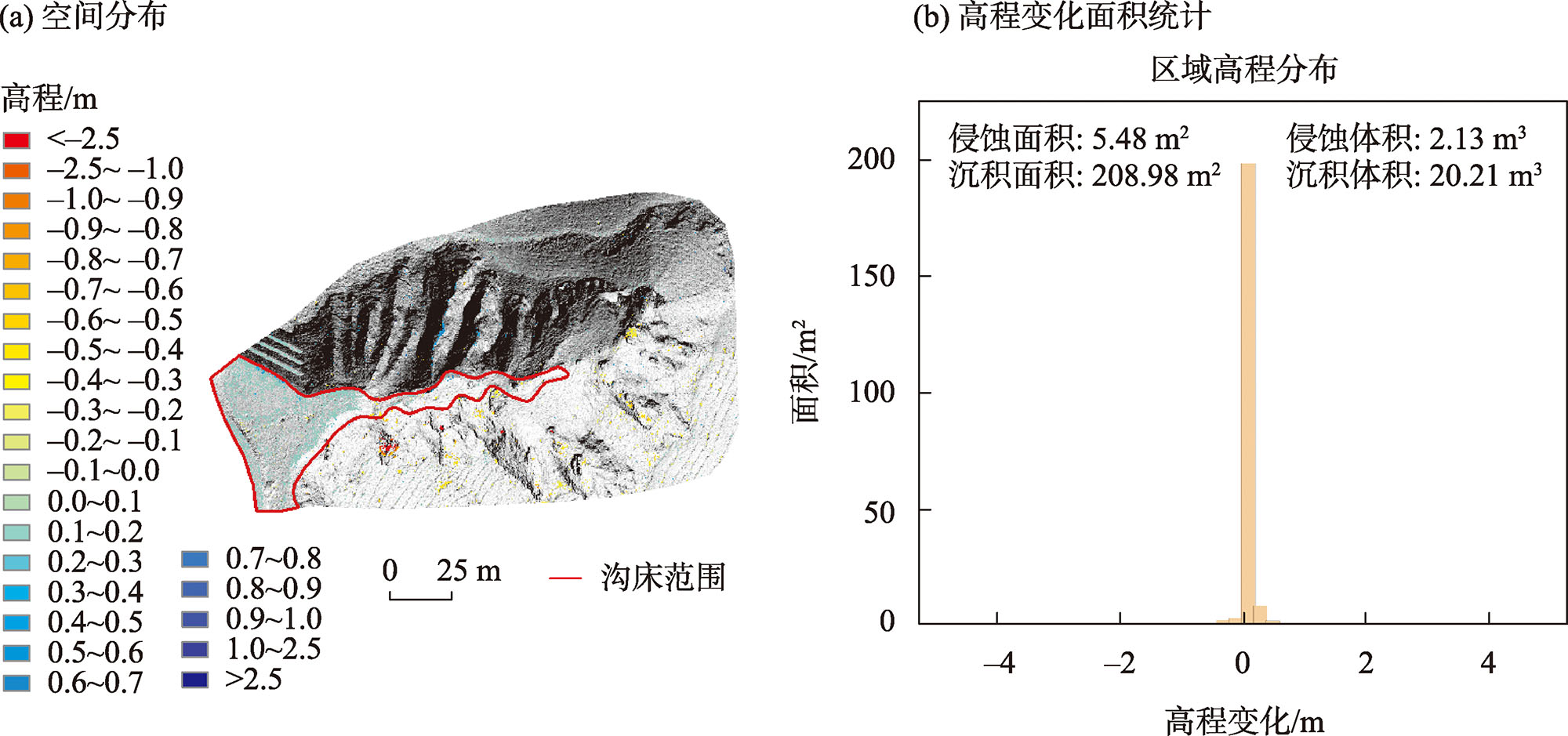

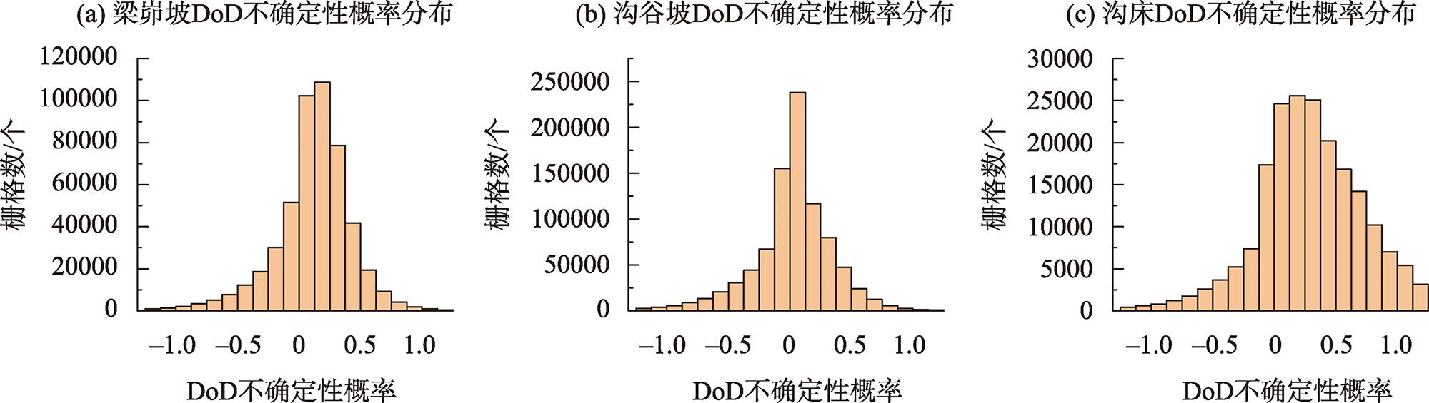
Fig. 9
DoD uncertainty probability distribution for different landforms in the study area"
| [1] | 陈朝良, 赵广举, 穆兴民, 等. 基于RUSLE模型的湟水流域土壤侵蚀时空变化[J]. 水土保持学报, 2021, 35(4): 73-79. |
| [ Chen Chaoliang, Zhao Guangju, Mu Xingmin, et al. Spatial-temporal change of soil erosion in Huangshui Watershed based on RUSLE model[J]. Journal of Soil and Water Conservation, 2021, 35(4): 73-79. ] | |
| [2] | 常梦迪, 王新军, 李娜, 等. 基于CSLE模型的天山北坡中段山区水力侵蚀时空变化特征及影响因素研究[J]. 干旱区研究, 2021, 38(4): 939-949. |
| [ Chang Mengdi, Wang Xinjun, Li Na, et al. Study on temporal and spatial variation characteristics and influencing factors of hydraulic erosion in the middle of the northen slope of Tianshan Mountains based on CSLE model[J]. Arid Zone Research, 2021, 38(4): 939-949. ] | |
| [3] | 赵蒙恩, 闫庆武, 刘政婷, 等. 鄂尔多斯市土壤侵蚀时空演变及影响因子分析[J]. 干旱区研究, 2022, 39(6): 1819-1831. |
| [ Zhao Mengen, Yan Qingwu, Liu Zhengting, et al. Analysis of temporal and spatial evolution and influencing factors of soil erosion in Ordos City[J]. Arid Zone Research, 2022, 39(6): 1819-1831. ] | |
| [4] | Zhao G, Mu X, Wen Z, et al. Soil erosion, conservation, and eco-environment changes in the Loess Plateau of China[J]. Land Degradation & Development, 2013, 24(5): 499-510. |
| [5] | 姚春艳, 刘洪鹄, 刘竞. 长江源区1980—2020年水沙变化规律[J]. 干旱区研究, 2023, 40(5): 726-736. |
| [ Yao Chunyan, Liu Honghu, Liu Jing. Variation of runoff and sediment in the headwaters of the Yangtze River from 1980 to 2020[J]. Arid Zone Research, 2023, 40(5): 726-736. ] | |
| [6] | 李宗善, 杨磊, 王国梁, 等. 黄土高原水土流失治理现状、问题及对策[J]. 生态学报, 2019, 39(20): 7398-7409. |
| [ Li Zongshan, Yang Lei, Wang Guoliang, et al. The management of soil and water conservation in the Loess Plateau of China: Present situations, problems, and counter-solutions[J]. Acta Ecologica Sinica, 2019, 39(20): 7398-7409. ] | |
| [7] | Li J, Liu Q, Feng X, et al. The synergistic effects of afforestation and the construction of check-dams on sediment trapping: Four decades of evolution on the Loess Plateau, China[J]. Land Degradation & Development, 2019, 30(6): 622-635. |
| [8] | 李敏. 水土保持对黄河输沙量的影响[J]. 中国水土保持科学, 2014, 12(6): 23-29. |
| [ Li Min. Effect of soil and water conservation on sediment discharge in the Yellow River[J]. Science of Soil and Water Conservation, 2014, 12(6): 23-29. ] | |
| [9] |
李朋飞, 李豆, 胡晋飞, 等. 机载LiDAR监测黄土高原土壤侵蚀的能力评估[J]. 测绘学报, 2023, 52(8): 1342-1354.
doi: 10.11947/j.AGCS.2023.20210698 |
|
[ Li Pengfei, Li Dou, Hu Jinfei, et al. Assessing the ability of airborne LiDAR to monitor soil erosion on the Chinese Loess Plateau[J]. Acta Geodaetica et Cartographica Sinica, 2023, 52(8): 1342-1354. ]
doi: 10.11947/j.AGCS.2023.20210698 |
|
| [10] |
杨昕, 汤国安, 袁宝印, 等. 黄土高原勺状沟壑特征及发育过程[J]. 地理研究, 2021, 40(7): 1870-1886.
doi: 10.11821/dlyj020200727 |
| [ Yang Xin, Tang Guo’an, Yuan Baoyin, et al. Characteristics and development process of spoon-shaped gully in the Loess Plateau[J]. Geographical Research, 2021, 40(7): 1870-1886. ] | |
| [11] | Goodwin N R, Armston J, Stiller I, et al. Assessing the repeatability of terrestrial laser scanning for monitoring gully topography: A case study from Aratula, Queensland, Australia[J]. Geomorphology, 2016, 262: 24-36. |
| [12] | Okyay U, Telling J, Glennie C L, et al. Airborne lidar change detection: An overview of Earth sciences applications[J]. Earth-Science Reviews, 2019, 198: 102929. |
| [13] | Wang X, Hongchao M A, Zhang L. Point cloud classification and accuracy analysis based on feature fusion[J]. Acta Geodaetica et Cartographica Sinica, 2021, 4(3): 11. |
| [14] | 黄先锋, 李卉, 王潇, 等. 机载LiDAR数据滤波方法评述[J]. 测绘学报, 2009, 38(5): 466-469. |
| [ Huang Xianfeng, Li Hui, Wang Xiao, et al. Filter algorithms of airborne LiDAR data: Review and prospects[J]. Acta Geodaetica et Cartographica Sinica, 2009, 38(5): 466-469. ] | |
| [15] | Schaffrath K R, Belmont P, Wheaton J M. Landscape-scale geomorphic change detection: Quantifying spatially variable uncertainty and circumventing legacy data issues[J]. Geomorphology, 2015, 250: 334-348. |
| [16] | Wheaton M J, Brasington J, Darby E S, et al. Accounting for uncertainty in DEMs from repeat topographic surveys: Improved sediment budgets[J]. Earth Surface Processes and Landforms, 2010, 35(2): 136-156. |
| [17] | Brasington J, Rumsby T B, McVey A R. Monitoring and modelling morphological change in a braided gravel-bed river using high resolution GPS-based survey[J]. Earth Surface Processes and Landforms, 2000, 25(9): 973-990. |
| [18] | Milan D J, Heritage G L, Large A R G, et al. Filtering spatial error from DEMs: Implications for morphological change estimation[J]. Geomorphology, 2011, 125(1): 160-171. |
| [19] | 苏建华, 王春梅, 庞国伟, 等. 黄土高原切沟空间分布特征[J]. 水土保持研究, 2023, 30(1): 134-143. |
| [ Su Jianhua, Wang Chunmei, Pang Guowei, et al. Spatial distribution of gullies in the Loess Plateau[J]. Research of Soil and Water Conservation, 2023, 30(1): 134-143. ] | |
| [20] | 韩守富, 赵宝强, 殷宗敏, 等. 基于PS InSAR技术的黄土高原地质灾害隐患识别[J]. 兰州大学学报(自然科学版), 2020, 56(1): 1-7. |
| [ Han Shoufu, Zhao Baoqiang, Yin Zongmin, et al. The identification of potential geological hazards on the Loess Plateau based on PS InSAR technology[J]. Journal of Lanzhou University (Natural Sciences), 2020, 56(1): 1-7. ] | |
| [21] |
代文, 汤国安, 胡光辉, 等. 基于无人机摄影测量的地形变化检测方法与小流域输沙模型研究[J]. 地理科学进展, 2021, 40(9): 1570-1580.
doi: 10.18306/dlkxjz.2021.09.011 |
|
[ Dai Wen, Tang Guo’an, Hu Guanghui, et al. Modelling sediment transport in space in a watershed based on topographic change detection by UAV survey[J]. Progress in Geography, 2021, 40(9): 1570-1580. ]
doi: 10.18306/dlkxjz.2021.09.011 |
|
| [22] | Wu L, Liu X, Ma X. Spatio-temporal evolutions of precipitation in the Yellow River basin of China from 1981 to 2013[J]. Water Science and Technology: Water Supply, 2016, 16(5): 1441-1450. |
| [23] | 王博. 延安市地貌与地质灾害相关性研究[D]. 西安: 长安大学, 2014. |
| [ Wang Bo. The Correlation Reseach on Geomorphology and Geological Disasters in Yan’an[D]. Xi’an: Chang’an University, 2014. ] | |
| [24] | 崔帅, 许强, 袁爽, 等. 基于组合熵权RSR法的董志塬沟谷发育评价[J]. 干旱区研究, 2023, 40(3): 481-491. |
| [ Cui Shuai, Xu Qiang, Yuan Shuang, et al. Evaluation of Dongzhi Loess Plateau gully development based on combined entropy weight Rank-Sum Ratio method[J]. Arid Zone Research, 2023, 40(3): 481-491. ] | |
| [25] | 林莹锋. 基于无人机载激光雷达技术的农村地籍调查测量[J]. 测绘与空间地理信息, 2023, 46(9): 175-178. |
| [ Lin Yingfeng. Rural cadastral survey based on unmanned airborne LiDAR technology[J]. Geomatics & Spatial Information Technology, 2023, 46(9): 175-178. ] | |
| [26] | Guo C, Xu Q, Dong X, et al. Geo-hazard recognition by airborne LiDAR technology in complex mountain areas[J]. Geomatics and Information Science of Wuhan University, 2021, 46(10): 1538-1547. |
| [27] | Evans J S, Hudak A T. A multiscale curvature algorithm for classifying discrete return LiDAR in forested environments[J]. IEEE Transactions on Geoscience and Remote Sensing, 2007, 45(4): 1029-1038. |
| [28] | Chaplot V, Darboux F, Bourennane H, et al. Accuracy of interpolation techniques for the derivation of digital elevation models in relation to landform types and data density[J]. Geomorphology, 2006, 77(1-2): 126-141. |
| [29] | Brasington J, Langham J, Rumsby B. Methodological sensitivity of morphometric estimates of coarse fluvial sediment transport[J]. Geomorphology, 2003, 53(3-4): 299-316. |
| [30] | Lane N S, Westaway M R, Hicks M D. Estimation of erosion and deposition volumes in a large, gravel-bed, braided river using synoptic remote sensing[J]. Earth Surface Processes and Landforms, 2003, 28(3): 249-271. |
| [31] | 李朋飞, 张晓晨, 党旭, 等. 基于三维激光扫描的坡沟系统侵蚀产沙过程研究[J]. 水土保持研究, 2023, 30(2): 13-21. |
| [ Li Pengfei, Zhang Xiaochen, Dang Xu, et al. Investigation of erosion processes on the slope-gully system using 3D laser scanning[J]. Research of Soil and Water Conservation, 2023, 30(2): 13-21. ] | |
| [32] | Bangen S, Hensleigh J, McHugh P, et al. Error modeling of DEMs from topographic surveys of rivers using fuzzy inference systems[J]. Water Resources Research, 2016, 52(2): 1176-1193. |
| [33] | Wheaton J M, Brasington J, Darby S E, et al. Linking geomorphic changes to salmonid habitat at a scale relevant to fish[J]. River Research and Applications, 2010, 26(4): 469-486. |
| [34] | Zadeh L A. Fuzzy sets[J]. Information and Control, 1965, 8(3): 338-353. |
| [35] | Guo Q, Li W, Yu H, et al. Effects of topographic variability and lidar sampling density on several DEM interpolation methods[J]. Photogrammetric Engineering & Remote Sensing, 2010, 76(6): 701-712. |
|
||