Arid Zone Research ›› 2024, Vol. 41 ›› Issue (4): 566-580.doi: 10.13866/j.azr.2024.04.04
• Land and Water Resources • Previous Articles Next Articles
ZHANG Hua( ), YA Haiting, XU Cungang
Received:2023-08-28
Revised:2023-12-14
Online:2024-04-15
Published:2024-04-26
ZHANG Hua, YA Haiting, XU Cungang. Remote sensing retrieval of soil moisture and estimation of vegetation water requirements in the north and south mountains of Lanzhou City[J].Arid Zone Research, 2024, 41(4): 566-580.
Add to citation manager EndNote|Reference Manager|ProCite|BibTeX|RefWorks

Fig. 1
Overview of the north and south mountains of Lanzhou City and the distribution of sampling points"

Tab. 1
Vegetation coefficients of various vegetation types in the early, middle, and late stages of growth in the north and south mountains of Lanzhou City"
| 初期(Kc,ini) | 中期(Kc,mid) | 后期(Kc,end) | |
|---|---|---|---|
| 林地 | 0.35 | 0.53 | 0.35 |
| 草地 | 0.55 | 0.83 | 0.55 |
| 耕地 | 0.40 | 0.65 | 0.40 |
Tab. 2
Actual measurement data of soil moisture in the north and south mountains of Lanzhou City"
| 样点编号 | 采样区 | 覆盖类型 | 海拔/m | 土壤水分实测值/% |
|---|---|---|---|---|
| JMB01 | 北山 | 草地 | 1897 | 9.20 |
| JMB02 | 北山 | 草地 | 1888 | 5.00 |
| JMB03 | 北山 | 灌木 | 1833 | 8.20 |
| JMB04 | 北山 | 草地 | 1833 | 5.20 |
| JMB05 | 北山 | 人工林 | 1770 | 7.40 |
| …… | …… | …… | …… | …… |
| JMB69 | 南山 | 耕地 | 1579 | 13.80 |
| JMB70 | 南山 | 草地 | 1685 | 11.80 |
| JMB71 | 南山 | 草地 | 1792 | 15.40 |
| JMB72 | 南山 | 草地 | 1744 | 12.80 |
| YZB01 | 北山 | 草地 | 1894 | 13.20 |
| YZB02 | 北山 | 耕地 | 1861 | 14.00 |
| YZB03 | 北山 | 耕地 | 1880 | 9.40 |
| YZB04 | 北山 | 人工林 | 1735 | 12.00 |
| YZB05 | 北山 | 灌木 | 1668 | 13.00 |
| …… | …… | …… | …… | …… |
| YZB40 | 南山 | 林地 | 1570 | 12.40 |
| YZB41 | 南山 | 草地 | 1650 | 6.00 |
| YZB42 | 南山 | 耕地 | 1615 | 8.00 |
| YZB43 | 南山 | 耕地 | 1605 | 7.00 |
| YZB39 | 南山 | 草地 | 1915 | 5.20 |
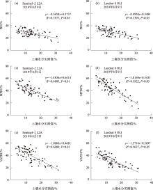
Fig. 2
Linear regression analysis of three drought indices and soil moisture measured data from two remote sensing images"
Tab. 3
Accuracy of three soil water inversion models with Sentinel-2 L2A and Landsat 8 OLI data"
| 数据源 | 干旱指数 | R2 | MAE/% | MRE/% | RMSE/% |
|---|---|---|---|---|---|
| Sentinel-2 L2A | PDI | 0.3764 | 8.66 | 7.56 | 6.25 |
| MPDI | 0.6924 | 4.13 | 4.24 | 3.24 | |
| VAPDI | 0.5713 | 7.42 | 5.74 | 5.41 | |
| Landsat 8 OLI | PDI | 0.3325 | 9.43 | 7.92 | 6.87 |
| MPDI | 0.5792 | 4.73 | 4.59 | 3.96 | |
| VAPDI | 0.4916 | 8.54 | 6.81 | 5.84 |
Fig. 3
Spatial distribution of soil moisture in the north and south mountains of Lanzhou City based on Sentinel-2 L2A and Landsat 8 OLI remote sensing images"

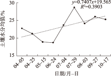
Fig. 4
Remote sensing inversion of soil water changes in the north and south mountains of Lanzhou City, April-October 2019"


Fig. 5
Distribution of drought levels in the north and south mountains of Lanzhou City based on Sentinel-2 L2A"

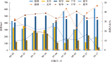
Fig. 6
Areas and proportions of different drought levels in the north and south mountains of Lanzhou City"

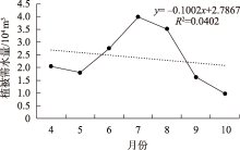
Fig. 7
The average value and change of vegetation water demand in the north and south mountains of Lanzhou City from April to October"


Fig. 8
Spatial distribution of vegetation water demand in the north and south mountains of Lanzhou City from April to October"

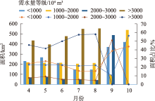
Fig. 9
Statistics of vegetation water requirements of various grades and their proportions to the total area of woodland, grassland and cultivated land in the north and south mountains of Lanzhou City from April to October"

| [1] |
Seneviratne S I, Corti T, Davin E L, et al. Investigating soil moisture-climate interactions in a changing climate: A review[J]. Earth-Science Reviews, 2010, 99(3-4): 125-161.
doi: 10.1016/j.earscirev.2010.02.004 |
| [2] | D’Odorico P, Laio F, Porporato A, et al. Ecohydrol-ogy of terrestrial ecosystems[J]. Bio-Science, 2010, 60(11): 898-907. |
| [3] | Huang X Y, Han Y G, Han L. Temporal and spatial variation of soil moisture in artificial forests in Hedong Sandy area and its relationship with meteorological factors[J]. Journal of Northeast Forestry University, 2020, 48(5): 29-34. |
| [4] |
Ma J Y, Li Z B, Ma B. Influences of revegetation mode on soil water dynamic in gully slope of the Chinese loess hilly-gully region[J]. Natural Hazards, 2020, 104(1): 51-72.
doi: 10.1007/s11069-020-04157-8 |
| [5] | 高露, 张圣微, 朱仲元, 等. 干旱半干旱区退化草地土壤水分变化及其对降雨时间格局的响应[J]. 水土保持学报, 2020, 34(1): 195-201. |
| [Gao Lu, Zhang Shengwei, Zhu Zhongyuan, et al. Soil moisture changes in degraded grassland and its response to rainfall temporal pattern in arid and semi-arid areas[J]. Journal of Soil and Water Conservation, 2020, 34(1): 195-201.] | |
| [6] | 杨娜, 郭兴国. 基于NDVI分区的全国草地生态系统覆盖区土壤水分遥感反演[J]. 水土保持研究, 2022, 29(3): 147-155. |
| [Yang Na, Guo Xingguo. Research for remote sensing retrieval of soil moisture in grassland ecosystem in China based on NDVI partition[J]. Research of Soil and Water Conservation, 2022, 29(3): 147-155.] | |
| [7] |
Wilson T B, Witkowski E T F. Water requirements for germination and early seedling establishment in four African savanna woody plant species[J]. Journal of Arid Environments, 1998, 38(4): 541-550.
doi: 10.1006/jare.1998.0362 |
| [8] | 张丽, 董增川, 赵斌. 干旱区天然植被生态需水量计算方法[J]. 水科学进展, 2003, 14(6): 745-748. |
| [Zhang Li, Dong Zengchuan, Zhao Bin. Method for estimating ecological water requirement of natural vegetation in arid area[J]. Advances in Water Science, 2003, 14(6): 745-748.] | |
| [9] | 郭巧玲, 杨云松, 陈志辉, 等. 额济纳绿洲植被生态需水及其估算[J]. 水资源与水工程学报, 2010, 21(3): 80-84. |
| [Guo Qiaoling, Yang Yunsong, Chen Zhihui, et al. Ecological water requirements of vegetation in Ejina Oasis[J]. Journal of Water Resources and Water Engineering, 2010, 21(3): 80-84.] | |
| [10] | 康绍忠, 张书函, 张富仑, 等. 积水入渗条件下土壤水分动态变化的野外观测与分析——以内蒙古敖包小流域为例[J]. 水土保持通报, 1997, 17(1): 10-15. |
| [Kang Shaozhong, Zhang Shuhan, Zhang Fulun, et al. Observation and analysis of soil moisture dynamic state during infiltration period in Anbao water basin of Inner Mongolia[J]. Bulletin of Soil and Water Conservation, 1997, 17(1): 10-15.] | |
| [11] | 郑曼迪, 刘忠, 许昭辉, 等. 基于微波遥感的土壤水分反演估算研究进展[J/OL]. 土壤学报: 2023, 1-13. |
| [Zheng Mandi, Liu Zhong, Xu Zhaohui et al. Research progress of soil moisture estimation based on microwave remote sensing[J/OL]. Acta Pedologica Sinica: 2023, 1-13.] | |
| [12] |
Kong J L, Yang J, Zhen P P, et al. A coupling model for soil moisture retrieval in sparse vegetation covered areas based on microwave and optical remote sensing data[J]. IEEE Transactions on Geoscience and Remote Sensing, 2018, 56(12): 7162-7173.
doi: 10.1109/TGRS.2018.2849009 |
| [13] | Petropoulos G P, Ireland G, Barrett B. Surface soil moisture retrievals from remote sensing: Current status, products & future trends[J]. Physics and Chemistry of the Earth, Parts A/B/C, 2015, 83: 36-56. |
| [14] |
Groeneveld D P, Baugh W M, Sanderson J S, et al. Annual groundwater evapotranspiration mapped from single satellite scenes[J]. Journal of Hydrology, 2007, 344(1-2): 146-156.
doi: 10.1016/j.jhydrol.2007.07.002 |
| [15] | 谷祥辉, 张英, 桑会勇, 等. 基于哨兵2号时间序列组合植被指数的作物分类研究[J]. 遥感技术与应用, 2020, 35(3): 702-711. |
| [Gu Xianghui, Zhang Ying, Sang Huiyong, et al. Research on crop classification method based on Sentinel-2 time series combined vegetation index[J]. Remote Sensing Technology and Applications, 2020, 35(3): 702-711.] | |
| [16] | 姜灵海. 基于哨兵数据的土壤水分反演算法研究[D]. 成都: 电子科技大学, 2020. |
| [Jiang Linghai. Research on Soil Moisture Retreval Based on Sentinel Data[D]. Chengdu: University of Electronic Science and Technology of China, 2020.] | |
| [17] | Lee C S, Sohn E, Park J D, et al. Estimation of soil moisture using deep learning based on satellite data: A case study of South Korea[J]. GIScience &: Remote Sensing, 2019, 56(1): 43-67. |
| [18] | 杨涛, 宫辉力, 李小娟, 等. 土壤水分遥感监测研究进展[J]. 生态学报, 2010, 30(22): 6264-6277. |
| [Yang Tao, Gong Huili, Li Xiaojuan, et al. Progress of soil moisture monitoring in remote sensing[J]. Acta Ecologica Sinica, 2010, 30(22): 6264-6277.] | |
| [19] | 姚云军, 秦其明, 赵少华, 等. 基于MODIS短波红外光谱特征的土壤含水量反演[J]. 红外与毫米波学报, 2011, 30(1): 9-14, 79. |
| [Yao Yunjun, Qin Qiming, Zhao Shaohua, et al. Inversion of soil moisture content based on MODIS short wave infrared spectral characteristics[J]. Journal of Infrared and Millimeter Waves, 2011, 30(1): 9-14, 79. ] | |
| [20] |
Brosinsky A, Lausch A, Doktor D, et al. Analysis of spectral vegetation signal characteristics as a function of soil moisture conditions using hyperspectral remote sensing[J]. Journal of the Indian Society of Remote Sensing, 2014, 42(2): 311-324.
doi: 10.1007/s12524-013-0298-8 |
| [21] |
Fang L, Hain C R, Zhan X W, et al. An inter-comparison of soil moisture data products from satellite remote sensing and a land surface model[J]. International Journal of Applied Earth Observation and Geoinformation, 2016, 48: 37-50.
doi: 10.1016/j.jag.2015.10.006 |
| [22] | 杨媛媛, 徐长春, 罗映雪, 等. 基于植被蒸散发法的孔雀河流域天然植被生态需水估算[J]. 灌溉排水学报, 2020, 39(4): 106-115. |
| [Yang Yuanyuan, Xu Changchun, Luo Yingxue, et al. Estimation of ecological water requirement for the natural vegetation in the Kongque River Basin based on vegetation evapotranspiration[J]. Journal of Irrigation and Drainage, 2020, 39(4): 106-115.] | |
| [23] | 孙栋元, 胡想全, 金彦兆, 等. 疏勒河中游绿洲天然植被生态需水量估算与预测研究[J]. 干旱区地理, 2016, 39(1): 154-161. |
| [Sun Dongyuan, Hu Xiangquan, Jin Yanzhao, et al. Prediction and evaluation of ecological water requirement of natural vegetation in the middle reaches oasis of Shulehe River Basin[J]. Arid Land Geography, 2016, 39(1): 154-161.] | |
| [24] | 曹雷, 丁建丽, 牛增懿. 基于TVDI的艾比湖地区土壤水分含量时空变化分析[J]. 水土保持研究, 2016, 23(3): 43-47. |
| [Cao Lei, Ding Jianli, Niu Zengyi. Analysis of spatiotemporal change of soil moisture of the Ebinur Lake area based on TVDI[J]. Research of Soil and Water conservation, 2016, 23(3): 43-47.] | |
| [25] | 何连, 秦其明, 任华忠, 等. 利用多时相Sentinel-1 SAR数据反演农田地表土壤水分[J]. 农业工程学报, 2016, 32(3): 142-148. |
| [He Lian, Qin Qiming, Ren Huazhong, et al. Soil moisture retrieval using multi-temporal Sentinel-1 SAR data in agricultural areas[J]. Transactions of the Chinese Society of Agricultural Engineering, 2016, 32(3): 142-148.] | |
| [26] |
Han D, Yang G Lv, G. Ecological water requirement of vegetation and water stress assessment in the middle reaches of the Keriya river basin[J]. Remote Sensing, 2023, 15(18): 4638.
doi: 10.3390/rs15184638 |
| [27] |
Chen J, Wang C, Jiang H, et al. Estimating soil moisture using temperature-vegetation dryness index (TVDI) in the huang-huaihai (HHH) plain[J]. International Journal of Remote Sensing, 2011, 32(4): 1165-1177.
doi: 10.1080/01431160903527421 |
| [28] | 胡广录, 赵文智. 干旱半干旱区植被生态需水量计算方法评述[J]. 生态学报, 2008, 28(12): 6282-6291. |
| [Hu Guanglu, Zhao Wenzhi. Reviews on calculating methods of vegetation ecological water requirement in arid and semiarid regions[J]. Acta Ecologica Sinica, 2008, 28(12): 6282-6291.] | |
| [29] | 詹志明, 秦其明, 阿布都瓦斯提·吾拉木, 等. 基于NIR-Red光谱特征空间的土壤水分监测新方法[J]. 中国科学D辑: 地球科学, 2006, 36(11): 1020-1026. |
| [Zhan Zhiming, Qin Qiming, Abduwasti Gulam, et al. NIR-red spectral space based new method for soil moisture monitoring[J]. Science in China Ser. D Earth Sciences, 2006, 36(11): 1020-1026.] | |
| [30] | Kauth R J, Thomas G S. The tasselled cap-a graphic description of the spectral-temporal development of agricultural crops as seen by Landsat[C]// Proceedings of the Symposium on Machine Processing of Remotely Sensed Date, Purdue University of West Lafayette, Indiana, 1976: 41-51. |
| [31] | 聂艳, 贾付生, 朱亚星, 等. 基于高分一号影像的江汉平原表层土壤湿度指数反演研究[J]. 长江流域资源与环境, 2018, 27(5): 1124-1131. |
| [Nie Yan, Jia Fusheng, Zhu Yaxing, et al. Research on surface soil moisture index inversion in Jianghan plain based on GF-1 WFV image[J]. Resources and Environment in the Yangtze Basin, 2018, 27(5): 1124-1131.] | |
| [32] | 杨学斌, 秦其明, 姚云军, 等. PDI与MPDI在内蒙古干旱监测中的应用和比较[J]. 武汉大学学报(信息科学版), 2011, 36(2): 195-198. |
| [Yang Xuebin, Qin Qiming, Yao Yunjun, et al. Comparison and application of PDI and MPDI for drought monitoring in inner Mongolia[J]. Geomatics and Information Science of Wuhan University, 2011, 36(2): 195-198.] | |
| [33] |
Ghulam A, Qin Q, Teyip T, et al. Modified perpendicular drought index (MPDI): A real-time drought monitoring method[J]. ISPRS Journal of Photogrammetry and Remote Sensing, 2007, 62(2): 150-164.
doi: 10.1016/j.isprsjprs.2007.03.002 |
| [34] |
张琨, 吕一河, 傅伯杰, 等. 黄土高原植被覆盖变化对生态系统服务影响及其阈值[J]. 地理学报, 2020, 75(5): 949-960.
doi: 10.11821/dlxb202005005 |
| [Zhang Kun, Lv Yihe, Fu Bojie, et al. The effects of vegetation coverage changes on ecosystem service and their threshold in the Loess Plateau[J]. Acta Geography Sinica, 2020, 75(5): 949-960.] | |
| [35] | 吴春雷, 秦其明, 李梅, 等. 基于光谱特征空间的农田植被区土壤湿度遥感监测[J]. 农业工程学报, 2014, 30(16): 106-112. |
| [Wu Chunlei, Qin Qiming, Li Mei, et al. Soil moisture monitoring of vegetative area in farmland by remote sensing based on spectral feature space[J]. Transactions of the CSAE, 2014, 30(16): 106-112.] | |
| [36] |
Hain C R, Mecikalski J R, Anderson M C. Retrieval of an available water-based soil moisture proxy from thermal infrared remote sensing. Part I: methodology and validation[J]. Journal of Hydrometeorology, 2009, 10(3): 665-683.
doi: 10.1175/2008JHM1024.1 |
| [37] | 李仁强, 黄从红, 张文娟, 等. 林业生态系统服务功能评估手册[M]. 北京: 北京林业大学, 2014. |
| [Li Renqiang, Huang Conhong, Zhang Wenjuan, et al. Handbook of Forest Ecosystem Service Function Assessment[M]. Beijing: Beijing Forestry University, 2014.] | |
| [38] | Allen R G, Pereira L S, Raes D, et al. Crop evapotranspiration-Guidelines for computing crop water requirements-FAO Irrigation and drainage paper 56[J]. FAO Rome, 1998, 300(9): 37-58. |
| [39] | 聂艳, 马泽玥, 周逍峰, 等. 阿克苏河流域土壤湿度反演与监测研究[J]. 生态学报, 2019, 39(14): 5138-5148. |
| [Nie Yan, Ma Zeyue, Zhou Xiaofeng, et al. Soil moisture retrieval and monitoring in the Aksu River Basin[J]. Acta Ecologica Sinica, 2019, 39(14): 5138-5148.] | |
| [40] | 谷亚超, 于立武, 代庆. 干旱分类及常用计算方法概述[J]. 东北水利水电, 2011, 29(5): 37-39. |
| [Gu Yachao, Yu Liwu, Dai Qing. Drought classification and common calculation methods[J]. Northeast Water Resources and Hydropower, 2011, 29(5): 37-39.] | |
| [41] | 杜绍杰, 赵天杰, 施建成, 等. Sentinel-1和Sentinel-2协同反演地表土壤水分[J]. 遥感技术与应用, 2022, 37(6): 1404-1413. |
| [Du Shaojie, Zhao Tianjie, Shi Jiancheng, et al. Sentinel-1 and Sentinel-2 synergistic retrieval of surface soil moisture[J]. Remote Sensing Technology and Application, 2022, 37(6): 1404-1413.] | |
| [42] | 汪海娇, 田丽慧, 张登山, 等. 青海湖东沙地不同植被恢复措施下土壤水分变化特征[J]. 干旱区研究, 2021, 38(1): 76-86. |
| [Wang Haijiao, Tian Lihui, Zhang Dengshan, et al. Variation of soil moisture content in vegetation restoration area of sandy land at east shore of Qinghai Lake[J]. Arid Zone Research, 2021, 38(1): 76-86.] | |
| [43] | 董爽, 贾玉华, 樊向国, 等. 陕北六道沟流域地形破碎区土壤水分时空分布及其预测[J]. 土壤通报, 2023, 54(5): 1032-1040. |
| [Dong Shuang, Jia Yuhua, Fan Xiangguo, et al. The spatial-temporal distribution of soil moisture and its prediction in the fragmented terrain of Liudaogou Catchment[J]. Chinese Journal of Soil Science, 2023, 54(5): 1032-1040.] | |
| [44] | 马耘秀, 夏露, 范毅, 等. 不同土地利用和地形条件对黄土丘陵区土壤水分的影响[J]. 灌溉排水学报, 2022, 41(9): 77-84. |
| [Ma Yunxiu, Xia Lu, Fan Yi, et al. The combined effects of land usage and topography on soil moisture change in a loess area[J]. Journal of Irrigation and Drainage, 2022, 41(9): 77-84.] | |
| [45] | 石建周, 刘贤德, 田青, 等. 六盘山半干旱区华北落叶松林坡面土壤含水量的降雨响应[J]. 干旱区研究, 2023, 40(4): 594-604. |
| [Shi Jianzhou, Liu Xiande, Tian Qing, et al. Rainfall response of soil water content on a slope of Larix principis-rupprechtii plantation in the semi-arid Liupan Mountains[J]. Arid Zone Research, 2023, 40(4): 594-604.] | |
| [46] | 姚晓军, 张晓, 孙美平, 等. 1960-2010年中国西北地区水分盈亏量时空特征[J]. 地理研究, 2013, 32(4): 607-616. |
|
[Yao Xiaojun, Zhang Xiao, Sun Meiping, et al. Spatial-temporal characteristics of water deficit in Northwest China from 1960 to 2010[J]. Geographical Research, 2013, 32(4): 607-616.]
doi: 10.11821/yj2013040003 |
|
| [47] | 林莎, 贺康宁, 王莉, 等. 基于地统计学的黄土高寒区典型林地土壤水分盈亏状况研究[J]. 生态学报, 2020, 40(2): 728-737. |
| [Lin Sha, He Kangning, Wang Li, et al. Soil moisture surplus and loss of typical forestland in loess alpine area by the geostatistical analyst method[J]. Acta Ecologica Sinica, 2020, 40(2): 728-737.] | |
| [48] | 高琪, 王玉珍, 冯春晖, 等. 基于改进型光谱指数的荒漠土壤水分遥感反演[J]. 自然资源遥感, 2022, 34(1): 142-150. |
| [Gao Qi, Wang Yuzhen, Feng Chunhui, et al. Remote sensing inversion of desert soil moisture based on improved spectral indices[J]. Remote Sensing for Natural Resources, 2022, 34(1): 142-150.] | |
| [49] |
Huang S, Ding J, Zou J, et al. Soil moisture retrival based on sentinel-1 imagery under sparse vegetation coverage[J]. Sensors, 2019, 19(3): 589.
doi: 10.3390/s19030589 |
| [1] | WAN Jiayi, SHI Jiayu, ZHANG Huamin, LI Lanhui, DING Mingjun. Soil moisture variation characteristics of alpine meadow with different cover types in the Three-River Source Region [J]. Arid Zone Research, 2024, 41(8): 1343-1353. |
| [2] | YANG Zhuqing, WANG Lei, ZHANG Xue, SHEN Jianxiang, ZHANG Yijing, LI Xinyu, ZHANG Bo, NIU Jinshuai. Seed germination and seedling growth of typical sand-fixing plants in response to soil moisture [J]. Arid Zone Research, 2024, 41(5): 830-842. |
| [3] | HU Guanglu, LIU Peng, LI Jia’nan, TAO Hu, ZHOU Chengqian. Characteristics of soil moisture dynamics and influencing factors of three landscape types at the oasis edge in the middle reaches of the Heihe River [J]. Arid Zone Research, 2024, 41(4): 550-565. |
| [4] | SONG Dacheng, MA Quanlin, LIU Shiquan, WEI Linyuan, WU Hao, DUAN Xiaofeng, GUO Shujiang. Species diversity in Minqin clay sand barrier-artificial Haloxylon ammodendron plantations and the characteristics of soil moisture changes [J]. Arid Zone Research, 2024, 41(4): 618-628. |
| [5] | WANG Bo, ZHANG Jianjun, LAI Zongrui, ZHAO Jiongchang, HU Yawei, YANG Zhou, LI Yang, WEI Zhaoyang. Effect of soil moisture content on the accuracy of root configuration detection by ground penetrating radar [J]. Arid Zone Research, 2024, 41(3): 456-466. |
| [6] | LI Jiannan, SHI Haibin, MIAO Qingfeng, SHAN Dan, RONG Hao, WEN Yaqin. Effect of environmental factors on the transpiration water consumption of various artificial arbor stands [J]. Arid Zone Research, 2023, 40(8): 1312-1321. |
| [7] | JIJI Jiamen, CHENG Yiben, CHEN Linglong, WAN Pengxiang, ZHANG Yihui, YANG Wenbin, BAI Xuying, WANG Tao. Dynamic changes in soil moisture and its response to rainfall in Pinus sylvestris var. mongolica plantation in Horqin Sandy Land [J]. Arid Zone Research, 2023, 40(5): 756-766. |
| [8] | XUE Zhixuan, ZHANG Li, WANG Xinjun, LI Yongkang, ZHANG Guanhong, LI Peiyao. Downscaling analysis of SMAP soil moisture products in Gurbantunggut Desert [J]. Arid Zone Research, 2023, 40(4): 583-593. |
| [9] | SHI Jianzhou, LIU Xiande, TIAN Qing, YU Pengtao, WANG Yanhui. Rainfall response of soil water content on a slope of Larix principis-rupprechtii plantation in the semi-arid Liupan Mountains [J]. Arid Zone Research, 2023, 40(4): 594-604. |
| [10] | YANG Shuangqi, SONG Naiping, WANG Xing, CHEN Xiaoying, CHANG Daoqin. Spatiotemporal characteristics of sierozem and aeolian soil moisture levels in a desert steppe [J]. Arid Zone Research, 2023, 40(10): 1625-1636. |
| [11] | YUAN Limin,YANG Zhiguo,XUE Bo,GAO Haiyan,HAN Zhaorigetu. Heterogeneity of soil moisture of blowouts in HulunBuir grassland [J]. Arid Zone Research, 2022, 39(5): 1598-1606. |
| [12] | QIANG Yuquan,XU Xianying,ZHANG Jinchun,LIU Hujun,GUO Shujiang,DUAN Xiaofeng. Characteristics of stem sap flow of Haloxylon ammodendron and its response to environmental factors in Qingtu Lake, Minqin [J]. Arid Zone Research, 2022, 39(4): 1143-1154. |
| [13] | YANG Ziwei,CHE Zihan,LIU Fumei,CHEN Kelong. Precipitation gradient influence on daily greenhouse gas emission fluxes from a Qinghai Lake wetland [J]. Arid Zone Research, 2022, 39(3): 754-766. |
| [14] | WANG Jia,TIAN Qing,WANG Lide,HE Hongsheng,SONG Dacheng,GUO Chunxiu. Effects of different years of returning farmland on soil moisture and species diversity in Minqin Qingtu Lake area [J]. Arid Zone Research, 2022, 39(2): 605-614. |
| [15] | CHENG Mengyuan,CAO Guangchao,ZHAO Meiliang,DIAO Erlong,HE Qixin,GAO Siyuan,QIU Xunxun,CHENG Guo. Temporal and spatial variation characteristics and influencial factors of soil moisture in the Xiangride-Qaidam River Basin [J]. Arid Zone Research, 2022, 39(2): 615-624. |
|
||