Arid Zone Research ›› 2022, Vol. 39 ›› Issue (2): 615-624.doi: 10.13866/j.azr.2022.02.28
• Ecology and Environment • Previous Articles Next Articles
CHENG Mengyuan1,2,3( ),CAO Guangchao2,3,4(),ZHAO Meiliang1,2,3,DIAO Erlong1,2,3,HE Qixin1,2,3,GAO Siyuan1,2,3,QIU Xunxun1,2,3,CHENG Guo1,2,3
Received:2021-07-13
Revised:2021-09-15
Online:2022-03-15
Published:2022-03-30
Contact:
Guangchao CAO
E-mail:chengmengyuan2527@163.com;caoguangchao@126.com
CHENG Mengyuan,CAO Guangchao,ZHAO Meiliang,DIAO Erlong,HE Qixin,GAO Siyuan,QIU Xunxun,CHENG Guo. Temporal and spatial variation characteristics and influencial factors of soil moisture in the Xiangride-Qaidam River Basin[J].Arid Zone Research, 2022, 39(2): 615-624.
Add to citation manager EndNote|Reference Manager|ProCite|BibTeX|RefWorks
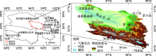
Fig. 1
Location of Xiangride-Qaidam River Basin"

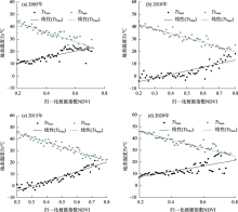
Fig. 2
The Ts-NDVI feature space in June 2005, 2010, 2015 and 2020"

Tab. 1
The dry and wet edge equations in the Xiangride-Qaidam River basin growing season in 2005, 2010, 2015 and 2020"
| 日期/年-月 | 干边方程 | 湿边方程 |
|---|---|---|
| 2005-05 | y=-52.4066x+325.323(R2=0.67) | y=33.4943x+272.560(R2=0.26) |
| 2005-06 | y=-37.8626x+323.323(R2=0.85) | y=25.0348x+278.239(R2=0.65) |
| 2005-07 | y=-32.2040x+325.900(R2=0.84) | y=25.7602x+270.864(R2=0.78) |
| 2005-08 | y=-34.9882x+321.051(R2=0.90) | y=19.6983x+275.720(R2=0.78) |
| 2005-09 | y=-64.4123x+319.680(R2=0.83) | y=31.7887x+264.923(R2=0.69) |
| 2010-05 | y=-54.7465x+322.947(R2=0.88) | y=9.75978x+281.279(R2=0.05) |
| 2010-06 | y=-35.1560x+321.496(R2=0.91) | y=30.8990x+262.305(R2=0.67) |
| 2010-07 | y=-31.6394x+328.951(R2=0.87) | y=11.9408x+287.259(R2=0.42) |
| 2010-08 | y=-28.3611x+315.728(R2=0.90) | y=12.2574x+280.724(R2=0.50) |
| 2010-09 | y=-48.1733x+313.477(R2=0.82) | y=22.8277x+269.387(R2=0.74) |
| 2015-05 | y=-74.4990x+329.596(R2=0.81) | y=52.4601x+263.142(R2=0.69) |
| 2015-06 | y=-40.6154x+326.026(R2=0.92) | y=40.5084x+260.587(R2=0.89) |
| 2015-07 | y=-25.4209x+324.712(R2=0.88) | y=20.5190x+284.490(R2=0.55) |
| 2015-08 | y=-33.8357x+323.004(R2=0.75) | y=23.2733x+278.474(R2=0.55) |
| 2015-09 | y=-40.7949x+312.469(R2=0.83) | y=23.3449x+276.902(R2=0.34) |
| 2020-05 | y=-74.9227x+329.098(R2=0.86) | y=22.6295x+272.789(R2=0.12) |
| 2020-06 | y=-32.8359x+324.519(R2=0.85) | y=20.9803x+275.909(R2=0.44) |
| 2020-07 | y=-36.4775x+329.062(R2=0.93) | y=13.3870x+279.855(R2=0.39) |
| 2020-08 | y=-38.1032x+324.959(R2=0.88) | y=11.6917x+282.224(R2=0.48) |
| 2020-09 | y=-42.4479x+314.101(R2=0.87) | y=16.5646x+278.758(R2=0.25) |
Tab. 2
TVDI value in 2005, 2010, 2015 and 2020"
| 年份 | 月份 | |||||
|---|---|---|---|---|---|---|
| 5月 | 6月 | 7月 | 8月 | 9月 | 生长季平均值 | |
| 2005 | 0.54 | 0.65 | 0.66 | 0.64 | 0.57 | 0.61 |
| 2010 | 0.54 | 0.65 | 0.65 | 0.66 | 0.54 | 0.61 |
| 2015 | 0.59 | 0.62 | 0.73 | 0.67 | 0.59 | 0.64 |
| 2020 | 0.51 | 0.62 | 0.62 | 0.59 | 0.58 | 0.58 |

Fig. 3
Area share of TVDI classification results in 2005, 2010, 2015 and 2020"

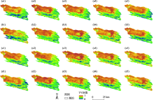
Fig. 4
TVDI inversion results of vegetation growing season in Xiangride-Qaidam River Basin"

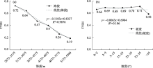
Fig. 5
The relationship between TVDI and altitude, TVDI and slope"

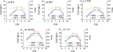
Fig. 6
Relations between average temperature and TVDI in Xiangride-Qaidam River Basin"

| [1] | 李海霞, 杨井, 陈亚宁, 等. 基于MODIS数据的新疆地区土壤湿度反演[J]. 草业学报, 2017, 26(6):16-27. |
| [ Li Haixia, Yang Jing, Chen Yaning, et al. Retrieval of soil moisture information in Xinjiang using MODIS[J]. Journal of Acta Prataculturae Sinica, 2017, 26(6):16-27. ] | |
| [2] |
邓雅文, 凌子燕, 孙娜, 等. 基于广义回归神经网络的京津冀地区土壤湿度遥感逐日估算研究[J]. 地球信息科学学报, 2021, 23(4):749-761.
doi: 10.12082/dqxxkx.2021.200149 |
|
[ Deng Yawen, Ling Ziyan, Sun Na, et al. Daily estimation of soil moisture over Beijing-Tianjin-Hebei Region based on General Regression Neural Network Model[J]. Journal of Geo-information Science, 2021, 23(4):749-761. ]
doi: 10.12082/dqxxkx.2021.200149 |
|
| [3] | 王娜, 易桂花, 张廷斌, 等. 基于TVDI的青藏高原腹地生长季土壤湿度时空变化及其气候响应[J]. 草业科学, 2020, 37(11):2185-2197. |
| [ Wang Na, Yi Guihua, Zhang Tingbin, et al. Spatiotemporal and climate-related variations in soil moisture during the growing season in the hinterland of the Qinghai-Tibet Plateau: An analysis using the temperature-vegetation dryness index[J]. Pratacultural Science, 2020, 37(11):2185-2197. ] | |
| [4] | 王佳新, 萨楚拉, 毛克彪, 等. 蒙古高原土壤湿度时空变化格局及其对气候变化的响应[J]. 国土资源遥感, 2021, 33(1):231-239. |
| [ Wang Jiaxin, Sa Chula, Mao Kebiao, et al. Temporal and spatial variation of soil moisture in the Mongolian Plateau and its response to climate change[J]. Remote Sensing for Land and Resources, 2021, 33(1):231-239. ] | |
| [5] | 杨玲, 杨艳昭. 基于TVDI的西辽河流域土壤湿度时空格局及其影响因素[J]. 干旱区资源与环境, 2016, 30(2):76-81. |
| [ Yang Ling, Yang Yanzhao. The spatial and temporal pattern of soil moisture in the west Liaohe river basin based on TVDI method and its influencing factors[J]. Journal of Arid Land Resources and Environment, 2016, 30(2):76-81. ] | |
| [6] | 聂艳, 马泽玥, 周逍峰, 等. 阿克苏河流域土壤湿度反演与监测研究[J]. 生态学报, 2019, 39(14):5138-5148. |
| [ Nie Yan, Ma Zeyue, Zhou Xiaofeng, et al. Soil moisture retrieval and monitoring in the Aksu River basin[J]. Acta Ecologica Sinica, 2019, 39(14):5138-5148. ] | |
| [7] | Waston K, Pohn H A. Thermal interia mapping from satellite discrimination of geology unit in Oman[J]. Journal of Research of the U. S. Geological Survey, 1974, 2(2):147-158. |
| [8] | 王静, 方锋, 黄鹏程, 等. AMSR-E土壤水分产品评价及在干旱监测中的应用[J]. 干旱区研究, 2021, 38(3):650-664. |
| [ Wang Jing, Fang Feng, Huang Pengcheng, et al. Evaluation of advanced microwave scanning radiometer for EOS(AMSR-E) soil moisture products over China and its application in drought monitoring[J]. Arid Zone Research, 2021, 38(3):650-664. ] | |
| [9] | 李占杰, 陈基培, 刘艳民, 等. 土壤水分遥感反演研究进展[J]. 北京师范大学学报(自然科学版), 2020, 56(3):474-481. |
| [ Li Zhanjie, Chen Jipei, Liu Yanmin, et al. Soil moisture retrieval from remote sensing[J]. Journal of Beijing Normal University(Natural Science), 2020, 56(3):474-481. ] | |
| [10] | 李毅, 陈新国, 赵会超, 等. 土壤干旱遥感监测的最新研究进展[J]. 水利与建筑工程学报, 2021, 19(1):1-7. |
| [ Li Yi, Chen Xinguo, Zhao Huichao, et al. Latest advances of soil drought and its monitoring based on remote sensing[J]. Journal of Water Resources and Architectural Engineering, 2021, 19(1):1-7. ] | |
| [11] | 刘一哲, 冯文兰, 扎西央宗, 等. 基于MODIS TVDI和模糊数学方法的藏北地区旱情等级遥感监测[J]. 干旱区研究, 2020, 37(1):86-96. |
| [ Liu Yizhe, Feng Wenlan, Zhaxi Yangzong, et al. Remote sensing monitoring of drought level in north Tibet based on MODIS TVDI and Fuzzy Mathematics[J]. Arid Zone Research, 2020, 37(1):86-96. ] | |
| [12] |
Cao Xiaoming, Feng Yixing, Shi Zhongjie. Spatio-temporal variations in drought with remote sensing from the Mongolian Plateau during 1982-2018[J]. Chinese Geographical Science, 2020, 30(6):1081-1094.
doi: 10.1007/s11769-020-1167-3 |
| [13] | 毛军. 柴达木盆地香日德绿洲灌溉对地下水的影响及生态响应研究[D]. 北京: 北京林业大学, 2007. |
| [ Mao Jun. Study on the Impact of Irrigation on Groundwater and its Ecological Response of Xiangride Oasis in Qaidum Basin[D]. Beijing: Beijing Forestry University, 2007. ] | |
| [14] | 王发科, 雷玉红, 都占良, 等. 气候变化对柴达木盆地主要农作物产量的影响[J]. 中国农学通报, 2020, 36(14):107-112. |
| [ Wang Fake, Lei Yuhong, Du Zhanliang, et al. Climate change affects major crops’yield in Qaidam Basin[J]. Chinese Agricultural Science Bulletin, 2020, 36(14):107-112. ] | |
| [15] | 张家好. 香日德-诺木洪山前平原地区地下水资源评价[D]. 北京: 中国地质大学, 2013. |
| [ Zhang Jiahao. Groundwater Resource Evaluation of Xiangride-Nuomuhong Piedmont Plain[D]. Beijing: China University of Geosciences, 2013. ] | |
| [16] | 朱明帮. 基于3S技术的都兰县土地利用变化及枸杞地光谱识别研究[D]. 青海: 青海大学, 2017. |
| [ Zhu Mingbang. Study on Land Use Change and Spectral Recognition of Lycium barbarum L. Area Based on “3S” Technique in Dulan County[D]. Qinghai: Qinghai University, 2017. ] | |
| [17] | 肖洋, 张翔, 朱才荣, 等. 土壤湿度动态变化研究进展[J]. 中国农村水利水电, 2014, 56(12):9-12, 16. |
| [ Xiao Yang, Zhang Xiang, Zhu Cairong, et al. Research on the dynamics of soil moisture[J]. China Rural Water and Hydropower, 2014, 56(12):9-12, 16. ] | |
| [18] |
Sandholt I, Rasmussen K, Andersen J. A simple interpretation of the surface temperature/vegetation index space for assessment of surface moisture status[J]. Remote Sensing of Environment, 2002, 79(2):213-224.
doi: 10.1016/S0034-4257(01)00274-7 |
| [19] | 高雅, 王晓飞, 高懋芳, 等. 基于温度植被干旱指数的曲靖市干旱监测研究[J]. 中国农学通报, 2020, 36(9):37-45. |
| [ Gao Ya, Wang Xiaofei, Gao Maofang, et al. Drought monitoring in Qujing based on temperature vegetation drought index[J]. Chinese Agricultural Science Bulletin, 2020, 36(9):37-45. ] | |
| [20] | 叶伟林, 周自强, 石三娥, 等. 基于TVDI的甘肃黑方台土壤湿度分布及影响因素分析[J]. 甘肃科学学报, 2020, 32(6):50-58. |
| [ Ye Weilin, Zhou Ziqiang, Shi San’e, et al. Analysis of spatio-temporal distribution of soil moisture and influencing factors in Hei-fangtai area based on TVDI[J]. Journal of Gansu Sciences, 2020, 32(6):50-58. ] | |
| [21] | 徐建华. 现代地理学中的数学方法[M]. 第二版. 北京: 高等教育出版社, 2002. |
| [ Xu Jianhua. Mathematical Modem Geography[M]. 2th Ed. Beijing: Higher Education Press, 2002. ] | |
| [22] | 王汉文, 原喜忠, 雷胜友, 等. 基于TVDI的不同土地类型土壤湿度趋势研究[J]. 河南理工大学学报(自然科学版), 2020, 39(5):50-60. |
| [ Wang Hanwen, Yuan Xizhong, Lei Shengyou, et al. Study on soil moisture trend of different land types based on TVDI[J]. Journal of Henan Polytechnic University(Natural Science), 2020, 39(5):50-60. ] | |
| [23] | 杨茹, 高超, 查芊郁, 等. 不同植被指数在基于TVDI方法反演土壤水分中的应用[J]. 测绘与空间地理信息, 2020, 43(2):33-37. |
| [ Yang Ru, Gao Chao, Zha Qianyu, et al. Application of different vegetation indexes in soil moisture inversion based on TVDI[J]. Geomatics & Spatial Information Technology, 2020, 43(2):33-37. ] | |
| [24] |
李彩瑛, 阎建忠, 刘林山, 等. 基于TVDI的羌塘高原夏季土壤湿度变化分析[J]. 地理研究, 2017, 36(11):2101-2111.
doi: 10.11821/dlyj201711006 |
|
[ Li Caiying, Yan Jianzhong, Liu Linshan, et al. Analysis of soil moisture variation in summer of Qiangtang Plateau based on TVDI[J]. Geographical Research, 2017, 36(11):2101-2111. ]
doi: 10.11821/dlyj201711006 |
|
| [25] | 吴英杰, 全强, 陈晓俊, 等. 2000—2018年锡林郭勒地区干旱时空变化及其气候响应[J]. 干旱区地理, 2020, 43(5):1289-1297. |
| [ Wu Yingjie, Quan Qiang, Chen Xiaojun, et al. Temporal and spatial variations of drought and climatic response in the Xilingol grassland from 2000 to 2018[J]. Arid Land Geography, 2020, 43(5):1289-1297. ] | |
| [26] | 张斯琦. 2000—2015年柴达木盆地植被覆盖度时空变化及其与环境因子的关系[D]. 河北: 河北师范大学, 2019. |
| [ Zhang Siqi. Spatial and Temporal Variation of Fractional Vegetation Cover and Its Relationship with Environmental Factors in Qaidam Basin during 2000-2015[D]. Hebei: Hebei Normal University, 2019. ] | |
| [27] | 钟祥浩, 刘淑珍. 中国山地分类研究[J]. 山地学报, 2014, 32(2):129-140. |
| [ Zhong Xianghao, Liu Shuzhen. Research on the mountain classification in China[J]. Mountain Research, 2014, 32(2):129-140. ] | |
| [28] | 覃艺, 张廷斌, 易桂花, 等. 2000年以来内蒙古生长季旱情变化遥感监测及其影响因素分析[J]. 自然资源学报, 2021, 36(2):459-475. |
| [ Qin Yi, Zhang Tingbin, Yi Guihua, et al. Remote sensing monitoring and analysis of influencing factors of drought in Inner Mongolia growing season since 2000[J]. Journal of Natural Resources, 2021, 36(2):459-475. ] |
| [1] | LI Jiannan, SHI Haibin, MIAO Qingfeng, SHAN Dan, RONG Hao, WEN Yaqin. Effect of environmental factors on the transpiration water consumption of various artificial arbor stands [J]. Arid Zone Research, 2023, 40(8): 1312-1321. |
| [2] | JIJI Jiamen, CHENG Yiben, CHEN Linglong, WAN Pengxiang, ZHANG Yihui, YANG Wenbin, BAI Xuying, WANG Tao. Dynamic changes in soil moisture and its response to rainfall in Pinus sylvestris var. mongolica plantation in Horqin Sandy Land [J]. Arid Zone Research, 2023, 40(5): 756-766. |
| [3] | XUE Zhixuan, ZHANG Li, WANG Xinjun, LI Yongkang, ZHANG Guanhong, LI Peiyao. Downscaling analysis of SMAP soil moisture products in Gurbantunggut Desert [J]. Arid Zone Research, 2023, 40(4): 583-593. |
| [4] | SHI Jianzhou, LIU Xiande, TIAN Qing, YU Pengtao, WANG Yanhui. Rainfall response of soil water content on a slope of Larix principis-rupprechtii plantation in the semi-arid Liupan Mountains [J]. Arid Zone Research, 2023, 40(4): 594-604. |
| [5] | YANG Hang,HOU Jingwei,MA Caihong,YANG Chen,WANG Yanjuan. Spatio-temporal differentiation of the composite ecosystem resilience in the ecologically fragile area in the upper reaches of the Yellow River: A case study in Ningxia [J]. Arid Zone Research, 2023, 40(2): 303-312. |
| [6] | HUI Rong, TAN Huijuan, HUANG Lei, LI Xinrong. Characteristics of nutrient and enzyme activity in salt-affected soils of the Qaidam Basin [J]. Arid Zone Research, 2023, 40(11): 1776-1784. |
| [7] | NIU Zilu, WANG Lei, QI Tuoye, ZHANG Yijing, SHEN Jianxiang, YANG Zhuqing, WANG Entian, JIANG Shuting. Soil salinization characteristics in irrigation region of Yellow River of Hongsipu, Ningxia [J]. Arid Zone Research, 2023, 40(11): 1785-1796. |
| [8] | YANG Shuangqi, SONG Naiping, WANG Xing, CHEN Xiaoying, CHANG Daoqin. Spatiotemporal characteristics of sierozem and aeolian soil moisture levels in a desert steppe [J]. Arid Zone Research, 2023, 40(10): 1625-1636. |
| [9] | YAO Jia,CHEN Qihui,LI Qiongfang,CUI Gang,ZHANG Liangjing. Spatial and temporal variability of evapotranspiration and influencing factors in the Ili River-Balkhash Lake Basin [J]. Arid Zone Research, 2022, 39(5): 1564-1575. |
| [10] | YUAN Limin,YANG Zhiguo,XUE Bo,GAO Haiyan,HAN Zhaorigetu. Heterogeneity of soil moisture of blowouts in HulunBuir grassland [J]. Arid Zone Research, 2022, 39(5): 1598-1606. |
| [11] | QIANG Yuquan,XU Xianying,ZHANG Jinchun,LIU Hujun,GUO Shujiang,DUAN Xiaofeng. Characteristics of stem sap flow of Haloxylon ammodendron and its response to environmental factors in Qingtu Lake, Minqin [J]. Arid Zone Research, 2022, 39(4): 1143-1154. |
| [12] | YANG Ziwei,CHE Zihan,LIU Fumei,CHEN Kelong. Precipitation gradient influence on daily greenhouse gas emission fluxes from a Qinghai Lake wetland [J]. Arid Zone Research, 2022, 39(3): 754-766. |
| [13] | HE Qixin,CAO Guangchao,CAO Shengkui,CHENG Mengyuan,DIAO Erlong,GAO Siyuan,QIU Xunxun,ZHAO Meiliang,CHENG Guo. Hydrogen-oxygen isotope characteristics of water bodies in the Xiangride-Qaidam River Basin and its influencing factors [J]. Arid Zone Research, 2022, 39(3): 820-828. |
| [14] | YANG Fucheng,LIU Changyi,HU Xiasong,LI Xilai,FU Jiangtao,LU Haijing,SHEN Ziyan,XU Tong,YAN Cong,HE Weipeng. Study on physical and chemical properties and shear strength characteristics of root-soil composite system with different degradation degrees of alpine grassland in the source region of the Yellow River [J]. Arid Zone Research, 2022, 39(2): 560-571. |
| [15] | WANG Jia,TIAN Qing,WANG Lide,HE Hongsheng,SONG Dacheng,GUO Chunxiu. Effects of different years of returning farmland on soil moisture and species diversity in Minqin Qingtu Lake area [J]. Arid Zone Research, 2022, 39(2): 605-614. |
|
||