Arid Zone Research ›› 2022, Vol. 39 ›› Issue (6): 1706-1716.doi: 10.13866/j.azr.2022.06.02
• Weather and Applied Climate • Previous Articles Next Articles
LI Yankun1,2( ),GAO Liming1,2,3,ZHANG Lele1,2,3(),WU Xueqing1,2,LIU Xuanchen1,2,QI Wen1,2
Received:2022-04-16
Revised:2022-09-07
Online:2022-11-15
Published:2023-01-17
Contact:
Lele ZHANG
E-mail:liyankunkkk@163.com;zhang1986lele@163.com
LI Yankun,GAO Liming,ZHANG Lele,WU Xueqing,LIU Xuanchen,QI Wen. Comparison of downscaling methods for TRMM 3B43 precipitation data in the Qinghai Lake Basin and its surrounding areas[J].Arid Zone Research, 2022, 39(6): 1706-1716.
Add to citation manager EndNote|Reference Manager|ProCite|BibTeX|RefWorks
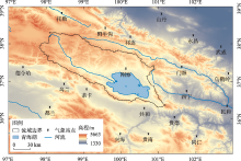
Fig. 1
Location of the study area and distribution of meteorological sites"

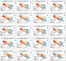
Fig. 2
Spatial distribution map of downscaling results in Qinghai Lake Basin"


Fig. 3
The elevation division of the study area (a) and the change of precipitation with elevation (b)"
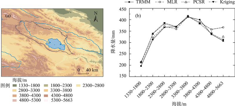

Fig. 4
Annual average scatter plot of measured precipitation and TRMM data and its downscaled data"


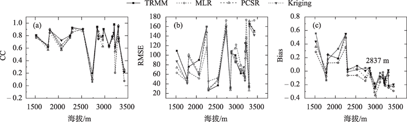
Fig. 5
Spatial distribution of CC (a-d), PCSR (e-h) and Bias (i-l) of TRMM, MLR, PCSR and Kriging on yearly scale"
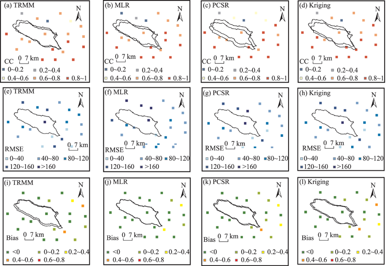
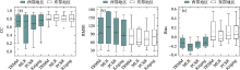
Fig. 6
Comparison of boxplots for accuracy evaluation of TRMM and three types of downscaled data in the eastern and western regions on the annual scale"
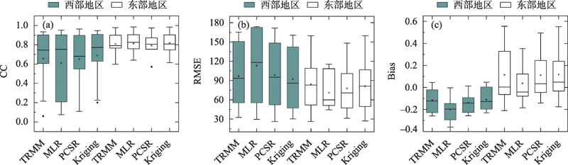

Fig. 7
Accuracy comparison between TRMM data and downscaled quarterly average data"
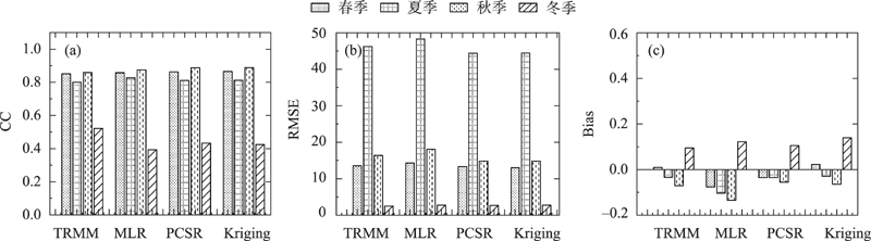
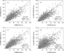
Fig. 8
Scatter plot of TRMM original monthly precipitation, downscaled monthly precipitation and measured monthly precipitation"

Fig. 9
Statistics of the accuracy evaluation indicators of the altitude and grid data of each station"
| [1] | 沈思民, 赵军, 刘佳茹, 等. 祁连山TRMM降水数据降尺度不同方法比较研究[J]. 山地学报, 2019, 37(6): 923-931. |
| [ Shen Simin, Zhao Jun, Liu Jiaru, et al. Comparative study on different downscaling methods of TRMM satellite precipitation data over the Qilian Mountains, China[J]. Mountain Research, 2019, 37(6): 923-931. ] | |
| [2] | 张乐乐, 高黎明, 陈克龙. 高分辨率遥感降水资料在青海湖流域及周边区域的适用性评价[J]. 水文, 2020, 40(5): 15-21. |
| [ Zhang Lele, Gao Liming, Chen Kelong. Applicability evaluation of high-resolution remote sensing precipitation data in Qinghai Lake basin and surrounding areas[J]. Journal of China Hydrology, 2020, 40(5): 15-21. ] | |
| [3] |
Ma Y, Tang G, Long D, et al. Similarity and error intercomparison of the GPM and its predecessor-TRMM multisatellite precipitation analysis using the best available hourly gauge network over the Tibetan Plateau[J]. Remote Sensing, 2016, 8(7): 569. ]
doi: 10.3390/rs8070569 |
| [4] | 袁飞, 赵晶晶, 任立良, 等. TRMM多卫星测雨数据在赣江上游径流模拟中的应用[J]. 天津大学学报: 自然科学与工程技术版, 2013, 46(7): 611-616. |
| [ Yuan Fei, Zhao Jingjing, Ren Liliang, et al. Application of TRMM multi-satellite rainfall data in runoff simulation of the upper reaches of Ganjiang River[J]. Journal of Tianjin University: Science and Technology, 2013, 46(7): 611-616. ] | |
| [5] | 窦世卿, 张寒博, 徐勇, 等. TRMM降水数据在长江流域的降尺度分析与校正[J]. 中国农业气象, 2021, 42(5): 377-389. |
| [ Dou Shiqing, Zhang Hanbo, Xu Yong, et al. Downscaling analysis and correction of TRMM precipitation data in the Yangtze River Basin[J]. Chinese Journal of Agrometeorology, 2021, 42(5): 377-389. ] | |
| [6] | 宋海清, 朱仲元, 李云鹏. 陆面同化及再分析降水资料在内蒙古地区的适用性[J]. 干旱区研究, 2021, 38(6): 1624-1636. |
| [ Song Haiqing, Zhu Zhongyuan, Li Yunpeng. Validation of land data assimilation and reanalysis precipitation datasets over Inner Mongolia[J]. Arid Zone Research, 2021, 38(6): 1624-1636. ] | |
| [7] | 杜军凯, 贾仰文, 李晓星, 等. 基于TRMM卫星降水的太行山区降水时空分布格局[J]. 水科学进展, 2019, 30(1): 1-13. |
| [ Du Junkai, Jia Yangwen, Li Xiaoxing, et al. Study on the spatial-temporal distribution pattern of precipitation in the Taihang Mountain region using TRMM data[J]. Advances in Water Science, 2019, 30(1): 1-13 ] | |
| [8] | 温婷婷, 郭英香, 董少睿, 等. 1979—2017年CRU, ERA5, CMFD格点降水数据在青藏高原适用性评估[J]. 干旱区研究, 2022, 39(3): 684-697. |
| [ Wen Tingting, Guo Yingxiang, Dong Shaorui, et al. Assessment of CRU, ERA5, CMFD grid precipitation data for the Tibetan Plateau from 1979 to 2017[J]. Arid Zone Research, 2022, 39(3): 684-697. ] | |
| [9] | 谷黄河, 余钟波, 杨传国, 等. 卫星雷达测雨在长江流域的精度分析[J]. 水电能源科学, 2010, 20(8): 3-6. |
| [ Gu Huanghe, Yu Zhongbo, Yang Chuanguo, et al. Accuracy analysis of satellite radar rain measurement in the Yangtze basin[J]. Water Resource And Power, 2010, 20(8): 3-6. ] | |
| [10] | 崔路明, 王思梦, 刘轶欣, 等. TRMM和GPM卫星降水数据在中国三大流域的降尺度对比研究[J]. 长江流域资源与环境, 2021, 30(6): 1317-1328. |
| [ Cui Luming, Wang Simeng, Liu Yixin, et al. Comparative study on downscaling of TRMM and GPM satellite precipitation data in three major river basins in China[J]. Resources and Environment in The Yangtze Basin, 2021, 30(6): 1317-1328. ] | |
| [11] | 孙铭悦, 吕海深, 朱永华, 等. 2套气象数据在资料缺乏地区的适用性评估——以呼图壁河流域为例[J]. 干旱区研究, 2022, 39(1): 94-103. |
| [ Sun Mingyue, Lv Haishen, Zhu Yonghua, et al. Applicability assessment of two meteorological datasets in areas lacking data with the Hutubi River Basin as an example[J]. Arid Zone Research, 2022, 39(1): 94-103. ] | |
| [12] | 盛夏, 石玉立, 丁海勇. 青藏高原GPM降水数据空间降尺度研究[J]. 遥感技术与应用, 2021, 36(3): 571-580. |
| [ Sheng Xia, Shi Yuli, Ding Haiyong. Spatial Downscaling of GPM Precipitation over the Tibetan Plateau[J]. Remote Sensing Technology and Application, 2021, 36(3): 571-580. ] | |
| [13] | 宁珊, 张正勇, 刘琳, 等. TRMM偏最小二乘降尺度降水模型在新疆不同地貌的适应性[J]. 农业工程学报, 2020, 36(12): 99-109. |
| [ Ning Shan, Zhang Zhengyong, Liu Lin, et al. Adaptability of precipitation estimation method based on TRMM data combined with partial least squares downscaling in different landforms of Xinjiang, China[J]. Transactions of the Chinese Society of Agricultural Engineering, 2020, 36(12): 99-109. ] | |
| [14] | Zhang T, Yang Y, Dong Z, et al. A multiscale assessment of three satellite precipitation products (TRMM, CMORPH, and PERSIANN) in the Three Gorges Reservoir Area in China[J]. Advances in Meteorology, 2021, 9979216: 1-27. |
| [15] |
Adler R F, Sapiano M R P, Huffman G J, et al. The Global Precipitation Climatology Project (GPCP) monthly analysis (new version 2.3) and a review of 2017 global precipitation[J]. Atmosphere, 2018, 9(4): 138.
doi: 10.3390/atmos9040138 |
| [16] | 李麒崙, 张万昌, 易路, 等. GPM与TRMM 降水数据在中国大陆的精度评估与对比[J]. 水科学进展, 2018, 29(3): 303-313. |
| [ Li Qilun, Zhang Wanchang, Yi Lu, et al. Accuracy evaluation and comparison of GPM and TRMM precipitation product over Mainland China[J]. Advances in Water Science, 2018, 29(3): 303-313. ] | |
| [17] |
Dhib S, Chaney N, Mannaerts C M, et al. Comparison of two bias correction methods for TRMM 3B42 satellite daily rainfall estimates over Northern Tunisia[J]. Arabian Journal of Geosciences, 2021, 14(7): 1-18.
doi: 10.1007/s12517-020-06304-8 |
| [18] |
刘江涛, 徐宗学, 赵焕, 等. 不同降水卫星数据反演降水量精度评价——以雅鲁藏布江流域为例[J]. 高原气象, 2019, 38(2): 386-396.
doi: 10.7522/j.issn.1000-0534.2018.00092 |
|
[ Liu Jiangtao, Xu Zongxue, Zhao Huan, et al. Accuracy assessment for two satellite precipitation products: Case studies in the Yarlung Zangbo River Basin[J]. Plateau Meteorology, 2019, 38(2): 386-396. ]
doi: 10.7522/j.issn.1000-0534.2018.00092 |
|
| [19] |
Prakash S, Mitra A K, AghaKouchak A, et al. A preliminary assessment of GPM-based multi-satellite precipitation estimates over a monsoon dominated region[J]. Journal of Hydrology, 2018, 556: 865-876.
doi: 10.1016/j.jhydrol.2016.01.029 |
| [20] |
Elnashar A, Zeng H, Wu B, et al. Downscaling TRMM monthly precipitation using google earth engine and google cloud computing[J]. Remote Sensing, 2020, 12(23): 3860.
doi: 10.3390/rs12233860 |
| [21] | 范雪薇, 刘海隆. 天山山区 TRMM 降水数据的空间降尺度研究[J]. 自然资源学报, 2018, 33(3): 478-488. |
| [ Fan Xuewei, Liu Hailong. Downscaling method of TRMM satellite precipitation data over the Tianshan Mountains[J]. Journal of Natural Resources, 2018, 33(3): 478-488. ] | |
| [22] | 张寒博, 窦世卿, 温颖, 等. 遥感降水数据空间降尺度及干旱时空监测[J]. 水土保持学报, 2022, 36(1): 153-160. |
| [ Zhang Hanbo, Dou Shiqing, Wen Ying, et al. Spatial downscaling of remote sensing precipitation data and spatiotemporal monitoring of drought[J]. Journal of Soil and Water Conservation, 2022, 36(1): 153-160. ] | |
| [23] | 李豪, 雷苑, 李鹏, 等. 复杂地形下 TRMM 降水数据的降尺度研究: 以四川省为例[J]. 中国农业气象, 2019, 40(10): 607-619. |
| [ Li Hao, Lei Yuan, Li Peng, et al. Downscaling of TRMM precipitation data under complex terrain: A case study of Sichuan Province[J]. Chinese Journal of Agrometeorology, 2019, 40(10): 607-619. ] | |
| [24] | 徐彬仁, 魏瑗瑗. 基于随机森林算法对青藏高原 TRMM 降水数据进行空间统计降尺度研究[J]. 国土资源遥感, 2018, 30(3): 181-188. |
| [ Xu Binren, Wei Yuanyuan. Spatial statistics of TRMM precipitation in the Tibetan Plateau using random forest algorithm[J]. Remote Sensing for Land & Resources, 2018, 30(3): 181-188. ] | |
| [25] |
Ghorbanpour A K, Hessels T, Moghim S, et al. Comparison and assessment of spatial downscaling methods for enhancing the accuracy of satellite-based precipitation over Lake Urmia Basin[J]. Journal of Hydrology, 2021, 596: 126055.
doi: 10.1016/j.jhydrol.2021.126055 |
| [26] | 高黎明, 张乐乐, 陈克龙, 等. 青海湖流域高寒湿地光合有效辐射特征[J]. 干旱区研究, 2018, 35(1): 50-56. |
| [ Gao Liming, Zhang Lele, Chen Kelong, et al. Characteristics of the photosynthetically active radiation in the alpine wetland, Qinghai lake watershed[J]. Arid Zone Research, 2018, 35(1): 50-56. ] | |
| [27] | 刘彩红, 王朋岭, 温婷婷, 等. 1960—2019 年黄河源区气候变化时空规律研究[J]. 干旱区研究, 2021, 38(2): 293-302. |
| [ Liu Caihong, Wang Pengling, Wen Tingting, et al. Spatio-temporal characteristics of climate change in the Yellow River source area from 1960 to 2019[J]. Arid Zone Research, 2021, 38(2): 293-302. ] | |
| [28] |
俞晓琴, 孟先强, 吴华武, 等. 青海湖流域有色可溶性有机物来源与特征分析[J]. 环境科学, 2022, 43(2): 826-836.
doi: 10.1021/es802638z |
|
[ Yu Xiaoqin, Meng Xianqiang, Wu Huawu, et al. Source and characteristics analysis of colored soluble organic matter in Qinghai Lake Basin[J]. Environmental Science, 2022, 43(2): 826-836. ]
doi: 10.1021/es802638z |
|
| [29] | 高晨轩. 利用多源卫星测高数据监测青海湖水位变化[D]. 兰州: 兰州交通大学, 2021. |
| [ Gao Chenxuan. Using Multi-source Satellite Altimeter Data to Monitor the Water Level Change of Qinghai Lake[D]. Lanzhou: Lanzhou Jiaotong University, 2021. ] | |
| [30] | Tang L, Duan X, Kong F, et al. Influences of climate change on area variation of Qinghai Lake on Qinghai-Tibetan Plateau since 1980s[J]. Scientific Reports, 2018, 8(1): 1-7. |
| [31] | 张晶, 鄂崇毅, 许乃军, 等. 青海湖流域气候变化对湖泊水位变化的影响[J]. 青海环境, 2021, 31(2): 71-75, 81. |
| [ Zhang Jing, E Chongyi, Xu Naijun, et al. Impact of climate change in Qinghai Lake Basin on lake water level change[J]. Journal of Qinghai Environment, 2021, 31(2): 71-75, 81. ] | |
| [32] | 王志刚, 曹生奎, 曹广超. 近15年来青海湖流域气温、降水变化对植被物候驱动分析[J]. 水土保持研究, 2022, 29(1): 249-255. |
| [ Wang Zhigang, Cao Shengkui, Cao Guangchao. Analysis on the drive of temperature and precipitation changes to vegetation phenology of the Qinghai Lake Basin in the past 15 years[J]. Research of Soil and Water Conservation, 2022, 29(1): 249-255. ] | |
| [33] | 姬凯, 王士新, 左洪超, 等. 东亚副热带急流经向位置对中国西北东部盛夏降水的影响[J]. 干旱区研究, 2020, 37(1): 10-17. |
| [ Ji Kai, Wang Shixin, Zuo Hongchao, et al. Effect of meridional position of East Asian subtropical jet on midsummer precipitation in eastern part of Northwest China[J]. Arid Zone Research, 2020, 37(1): 10-17. ] | |
| [34] | 杨昭明, 张调风. 1961—2017 年青藏高原东北部雨季降水量变化及其贡献度分析[J]. 干旱区研究, 2021, 38(1): 22-28. |
| [ Yang Zhaoming, Zhang Tiaofeng. Analysis of precipitation change and its contribution in the rainy season in the northeast Qinghai-Tibet Plateau from 1961 to 2017[J]. Arid Zone Research, 2021, 38(1): 22-28. ] | |
| [35] | 卢新玉, 魏鸣, 王秀琴, 等. TRMM-3B43降水产品在新疆地区的适用性研究[J]. 国土资源遥感, 2016, 28(3): 166-173. |
| [ Lu Xinyu, Wei Ming, Wang Xiuqin, et al. Applicability research on TRMM-3B43 precipitation over Xinjiang[J]. Remote Sensing for Land & Resources, 2016, 28(3): 166-173. ] | |
| [36] |
Xu R, Tian F, Yang L, et al. Ground validation of GPM IMERG and TRMM 3B42V7 rainfall products over southern Tibetan Plateau based on a high-density rain gauge network[J]. Journal of Geophysical Research: Atmospheres, 2017, 122(2): 910-924.
doi: 10.1002/2016JD025418 |
| [37] |
张乐乐, 高黎明, 赵林, 等. 降水观测误差修正研究进展[J]. 地球科学进展, 2017, 32(7): 723-730.
doi: 10.11867/j.issn.1001-8166.2017.07.0723 |
|
[ Zhang Lele, Gao Liming, Zhao Lin, et al. Review on correction of errors in precipitation measurement[J]. Advances in Earth Science, 2017, 32(7): 723-730. ]
doi: 10.11867/j.issn.1001-8166.2017.07.0723 |
|
| [38] |
Shi Y, Song L. Spatial downscaling of monthly TRMM precipitation based on EVI and other geospatial variables over the Tibetan Plateau from 2001 to 2012[J]. Mountain Research and Development, 2015, 35(2): 180-194.
doi: 10.1659/MRD-JOURNAL-D-14-00119.1 |
| [39] | 何晓波, 叶柏生, 丁永建. 青藏高原唐古拉山区降水观测误差修正分析[J]. 水科学进展, 2009, 20(3): 403-408. |
| [ He Xiaobo, Ye Baisheng, Ding Yongjian. Bias correction for precipitation mesuament in Tanggula Mountain Tibetan Plateau[J]. Advances in Water Science, 2009, 20(3): 403-408. ] | |
| [40] | 吴建峰, 陈阿林, 嵇涛, 等. TRMM 降水数据在复杂山地的精度评估——以重庆市为例[J]. 水土保持通报, 2014, 34(4): 201-207. |
| [ Wu Jianfeng, Chen Alin, Ji Tao, et al. Accuracy evaluation of tropical rainfall measuring mission [recipitation data in complex mountainous areas: Taking Chongqing City as an example[J]. Bulletin of Soil and Water Conservation, 2014, 34(4): 201-207. ] | |
| [41] | 李琼, 杨梅学, 万国宁, 等. TRMM 3B43降水数据在黄河源区的适用性评价[J]. 冰川冻土, 2016, 38(3): 620-633. |
| [ Li Qiong, Yang Meixue, Wan Guoning, et al. Analysis of the accuracy of TRMM 3B43 precipitation data in the source region of the Yellow River[J]. Journal of Glaciology and Geocryology, 2016, 38(3): 620-633. ] | |
| [42] |
Sapiano M R P, Arkin P A. An intercomparison and validation of high-resolution satellite precipitation estimates with 3-hourly gauge data[J]. Journal of Hydrometeorology, 2009, 10(1): 149-166.
doi: 10.1175/2008JHM1052.1 |
| [43] | Ren W, Yao T, Yang X, et al. Implications of variations in δ18O and δD in precipitation at Madoi in the eastern Tibetan Plateau[J]. Quaternary International, 2013, 313: 56-61. |
| [1] | ZHANG Jiaqi, LIU Zhao, HAN Zhongqing, WANG Lixia, ZHANG Jinxia, YUE Jiayin, GUAN Zilong. Trend change and prediction of blue-green water in the Jinghe River Basin under climate change [J]. Arid Zone Research, 2024, 41(12): 2045-2055. |
| [2] | ZHANG Yin, SUN Congjian, LIU Geng, CHAO Jinlong, GENG Tianwei. Response of NDSI in the Tarim River Basin mountainous areas to climate change over the past 20 years [J]. Arid Zone Research, 2024, 41(10): 1639-1648. |
| [3] | LI Yongguang, YUAN Guanghui. Biophysical effects of the different underlying factors on land the surface temperature in the Qinghai Lake Basin [J]. Arid Zone Research, 2024, 41(1): 24-35. |
| [4] | XUE Zhixuan, ZHANG Li, WANG Xinjun, LI Yongkang, ZHANG Guanhong, LI Peiyao. Downscaling analysis of SMAP soil moisture products in Gurbantunggut Desert [J]. Arid Zone Research, 2023, 40(4): 583-593. |
| [5] | SUN Guanfang, GAO Zhaoliang, ZHU Yan, YANG Jinzhong, QU Zhongyi. Spatio-temporal patterns of soil salinity in Hetao Irrigation District based on spatio-temporal Kriging [J]. Arid Zone Research, 2023, 40(2): 182-193. |
| [6] | WU Xueqing, ZHANG Lele, GAO Liming, LI Yankun, LIU Xuanchen. Dynamic change and driving force of net primary productivity in Qinghai Lake Basin [J]. Arid Zone Research, 2023, 40(11): 1824-1832. |
| [7] | CUI Jiaqi,LI Xianyue,SHI Haibin,SUN Yanan,MA Hongyu,JIAN Wenhao. Temporal and spatial variation change of groundwater environment in the salinized irrigation districts under the background of water-saving reconstruction [J]. Arid Zone Research, 2022, 39(3): 841-852. |
| [8] | YUCHI Wensi,MIAO Henglu,WANG Xingtian,GAO Tianming,WU Jiabin. Analysis of meteorological factors affecting drought in a desert steppe of the northern foot of Yinshan Mountain [J]. Arid Zone Research, 2021, 38(5): 1327-1334. |
| [9] | . Desertification and its driving factors in the Ordos Plateau,from 1986 to 2015 [J]. Arid Zone Research, 2020, 37(3): 749-. |
| [10] | HAN Peng-fei, WANG Xu-sheng, HU Xiao-nong, JIANG Xiao-wei, ZHOU Yan-yi. Dynamic Relationship between Lake Surface Evaporation and Meteorological Factors in the Badain Jaran Desert [J]. , 2018, 35(5): 1012-1020. |
| [11] | GAO Li-Ming, ZHANG Le-Le, CHEN Ke-Long, MAO Ya-Hui. Characteristics of the Photosynthetically Active Radiation in the Alpine Wetland, Qinghai lake watershed [J]. , 2018, 35(01): 50-56. |
| [12] | LI Cheng-Xiu, LI Xiao-Yan, YANG Tai-Bao, LI Yue-Tan-. Structure and Species Diversity of Meadow Community along the Shaliu River in the Qinghai Lake Basin [J]. , 2013, 30(6): 1028-1035. |
| [13] | ZHANG Jie, BAI Hong-Ying, YUAN Bo, MA Xin-Ping. Statistical Downscaling of Air Temperature Change in the Qinling Mountains [J]. , 2013, 30(2): 322-328. |
| [14] | CHAO Zhen-Hua. Study on Statistical Downscaling of Air Temperature in West China [J]. , 2011, 28(5): 879-884. |
| [15] | CAO Li-Guo, LIU Pu-Xing, ZHANG Ke-Xin, WANG Hong-Yan. Analysis on Response of Grasslands to Climate Change and Its Spatial Difference in Xilingol League [J]. , 2011, 28(5): 789-794. |
|
||