Arid Zone Research ›› 2023, Vol. 40 ›› Issue (2): 182-193.doi: 10.13866/j.azr.2023.02.03
• Land and Water Resources • Previous Articles Next Articles
SUN Guanfang1( ),GAO Zhaoliang1,ZHU Yan2(),YANG Jinzhong2,QU Zhongyi3
Received:2022-08-12
Revised:2022-10-12
Online:2023-02-15
Published:2023-03-08
SUN Guanfang, GAO Zhaoliang, ZHU Yan, YANG Jinzhong, QU Zhongyi. Spatio-temporal patterns of soil salinity in Hetao Irrigation District based on spatio-temporal Kriging[J].Arid Zone Research, 2023, 40(2): 182-193.
Add to citation manager EndNote|Reference Manager|ProCite|BibTeX|RefWorks
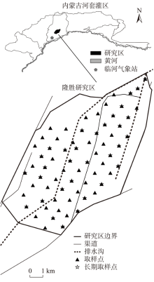
Fig. 1
Longsheng study area and soil salinity sampling locations"
Tab. 1
Statistical characteristics of soil salinity at four sampling times"
| 土层/m | 时间 | 观测数 | 均值 / (dS·m-1) | 中位数 / (dS·m-1) | 标准差 / (dS·m-1) | 变异 系数 | 峰度 | 偏度 | 最小值 / (dS·m-1) | 最大值 / (dS·m-1) |
|---|---|---|---|---|---|---|---|---|---|---|
| 0~0.2 | Y1705 | 65 | 0.34 | 0.23 | 0.39 | 1.14 | 18.52 | 4.18 | 0.13 | 2.34 |
| Y1709 | 66 | 0.35 | 0.23 | 0.28 | 0.78 | 5.1 | 2.12 | 0.1 | 1.55 | |
| Y1805 | 67 | 0.28 | 0.23 | 0.13 | 0.45 | 3.34 | 1.69 | 0.14 | 0.77 | |
| Y1809 | 66 | 0.28 | 0.2 | 0.21 | 0.77 | 11.34 | 3.18 | 0.08 | 1.29 | |
| 0.2~0.4 | Y1705 | 65 | 0.3 | 0.25 | 0.18 | 0.6 | 3.84 | 1.87 | 0.12 | 0.99 |
| Y1709 | 66 | 0.33 | 0.24 | 0.24 | 0.74 | 3.39 | 1.97 | 0.12 | 1.19 | |
| Y1805 | 67 | 0.29 | 0.23 | 0.15 | 0.52 | 1.39 | 1.42 | 0.13 | 0.76 | |
| Y1809 | 66 | 0.3 | 0.23 | 0.21 | 0.71 | 9.18 | 2.87 | 0.08 | 1.23 | |
| 0.4~0.6 | Y1705 | 65 | 0.31 | 0.27 | 0.21 | 0.66 | 10.29 | 2.74 | 0.11 | 1.35 |
| Y1709 | 66 | 0.32 | 0.26 | 0.2 | 0.63 | 1.99 | 1.57 | 0.07 | 0.96 | |
| Y1805 | 67 | 0.32 | 0.24 | 0.2 | 0.63 | 2.58 | 1.64 | 0.12 | 1.02 | |
| Y1809 | 66 | 0.32 | 0.26 | 0.2 | 0.63 | 3.14 | 1.77 | 0.1 | 1.03 | |
| 0.6~0.8 | Y1705 | 65 | 0.33 | 0.26 | 0.2 | 0.6 | 4.3 | 1.88 | 0.1 | 1.18 |
| Y1709 | 66 | 0.29 | 0.26 | 0.15 | 0.53 | 1.27 | 1.21 | 0.07 | 0.74 | |
| Y1805 | 67 | 0.33 | 0.26 | 0.2 | 0.61 | 2.22 | 1.62 | 0.12 | 1.03 | |
| Y1809 | 66 | 0.31 | 0.24 | 0.2 | 0.64 | 3.73 | 1.87 | 0.09 | 1.06 | |
| 0.8~1.0 | Y1705 | 65 | 0.33 | 0.27 | 0.19 | 0.57 | 5.64 | 2.06 | 0.1 | 1.18 |
| Y1709 | 66 | 0.28 | 0.27 | 0.13 | 0.47 | 1.94 | 1.17 | 0.07 | 0.73 | |
| Y1805 | 67 | 0.33 | 0.27 | 0.18 | 0.54 | 2.17 | 1.53 | 0.12 | 0.92 | |
| Y1809 | 66 | 0.29 | 0.22 | 0.17 | 0.61 | 3.3 | 1.8 | 0.09 | 0.89 | |
| 1.0~1.2 | Y1705 | 64 | 0.31 | 0.26 | 0.16 | 0.52 | 3.7 | 1.76 | 0.06 | 0.9 |
| Y1709 | 66 | 0.28 | 0.25 | 0.13 | 0.46 | 0.71 | 1.1 | 0.09 | 0.63 | |
| Y1805 | 67 | 0.33 | 0.27 | 0.17 | 0.53 | 2.26 | 1.53 | 0.11 | 0.9 | |
| Y1809 | 66 | 0.28 | 0.23 | 0.18 | 0.62 | 8.86 | 2.63 | 0.09 | 1.13 | |
| 1.2~1.4 | Y1705 | 51 | 0.29 | 0.24 | 0.15 | 0.51 | 5.79 | 1.98 | 0.12 | 0.92 |
| Y1709 | 66 | 0.26 | 0.24 | 0.12 | 0.44 | 1.83 | 1.24 | 0.09 | 0.68 | |
| Y1805 | 65 | 0.31 | 0.25 | 0.15 | 0.48 | 0.78 | 1.26 | 0.11 | 0.72 | |
| Y1809 | 66 | 0.27 | 0.23 | 0.15 | 0.56 | 4.2 | 1.85 | 0.1 | 0.91 | |
| 1.4~1.6 | Y1705 | 45 | 0.28 | 0.23 | 0.15 | 0.54 | 4.49 | 1.82 | 0.12 | 0.88 |
| Y1709 | 66 | 0.25 | 0.24 | 0.11 | 0.43 | 0.89 | 1.05 | 0.1 | 0.55 | |
| Y1805 | 64 | 0.29 | 0.24 | 0.13 | 0.46 | 2.4 | 1.53 | 0.14 | 0.78 | |
| Y1809 | 66 | 0.26 | 0.22 | 0.13 | 0.51 | 6.12 | 2.17 | 0.08 | 0.86 | |
| 1.6~1.8 | Y1705 | 29 | 0.32 | 0.27 | 0.19 | 0.61 | 5.14 | 2.04 | 0.12 | 1.01 |
| Y1709 | 66 | 0.26 | 0.24 | 0.12 | 0.48 | 5.72 | 1.76 | 0.07 | 0.81 | |
| Y1805 | 58 | 0.27 | 0.22 | 0.12 | 0.45 | 3.16 | 1.52 | 0.11 | 0.77 | |
| Y1809 | 66 | 0.25 | 0.23 | 0.12 | 0.47 | 2.99 | 1.64 | 0.08 | 0.65 |
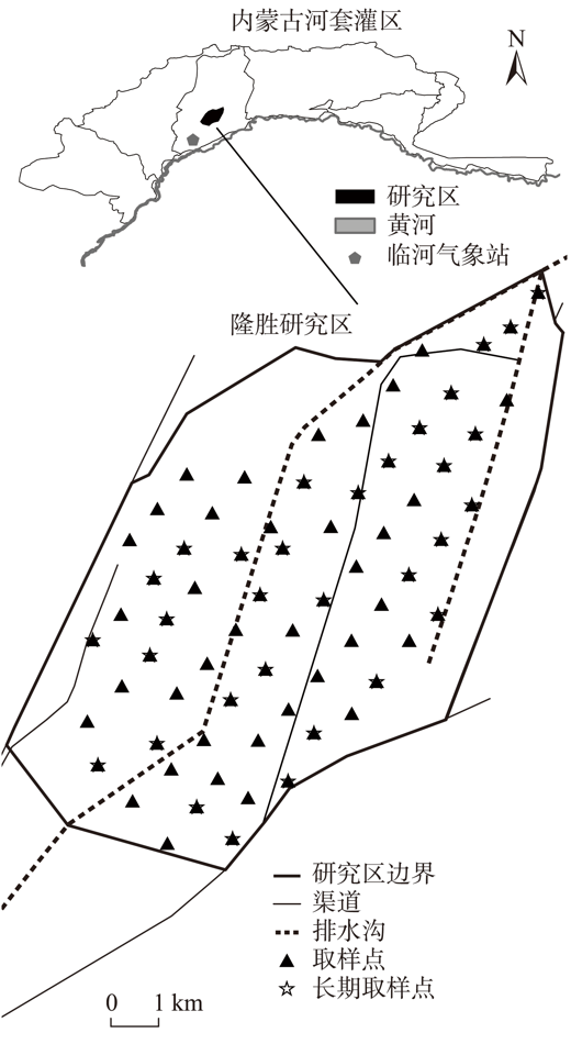
Fig. 2
Empirical (blue circle) and fitted spatio-temporal semivariogram surfaces of the soil salinity in each layer"

Tab. 2
The semivariogram models and parameters of soil salinity"
| 土层/m | C0 | 空间参数 | 时间参数 | 联合参数 | ||||||||
|---|---|---|---|---|---|---|---|---|---|---|---|---|
| CS | aS | CT | aT | CST | aST | α | ||||||
| 0~0.2 | 0.0063 | 0.0240 | 957.00 | 0.0282 | 292.70 | 0.0032 | 235.01 | 0.1000 | ||||
| 0.2~0.4 | 0.0081 | 0.0143 | 1438.69 | 0.0201 | 287.37 | 0.0092 | 1217.14 | 0.6647 | ||||
| 0.4~0.6 | 0.0186 | 0.0152 | 1001.61 | 0.0073 | 289.24 | 0.0162 | 1868.67 | 0.1000 | ||||
| 0.6~0.8 | 0.0080 | 0.0249 | 1615.07 | 0.0147 | 227.55 | 0.0074 | 1003.57 | 0.1856 | ||||
| 0.8~1.0 | 0.0055 | 0.0259 | 1916.53 | 0.0188 | 209.64 | 0.0009 | 1003.37 | 0.4790 | ||||
| 1.0~1.2 | 0.0028 | 0.0257 | 1323.09 | 0.0158 | 220.30 | 0.0009 | 955.91 | 3.0303 | ||||
| 1.2~1.4 | 0.0069 | 0.0169 | 863.06 | 0.0061 | 147.70 | 0.0093 | 1930.13 | 0.2737 | ||||
| 1.4~1.6 | 0.0061 | 0.0187 | 1127.09 | 0.0063 | 175.33 | 0.0061 | 1879.02 | 1.1730 | ||||
| 1.6~1.8 | 0.0042 | 0.0010 | 1863.53 | 0.0132 | 293.88 | 0.0241 | 1827.54 | 0.0978 | ||||
| 0~0.6 | 0.0089 | 0.0280 | 1250.41 | 0.0046 | 246.15 | 0.0017 | 1861.18 | 0.0244 | ||||
| 0.6~1.2 | 0.0054 | 0.0290 | 1945.91 | 0.0090 | 244.73 | 0.0013 | 1259.28 | 0.0391 | ||||
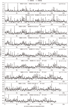
Fig. 3
Soil salinity cross-validation results for the spatio-temporal Kriging"
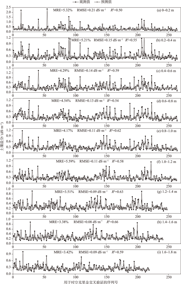

Fig. 4
The cross-validation results of traditional spatial Kriging and spatio-temporal Kriging"
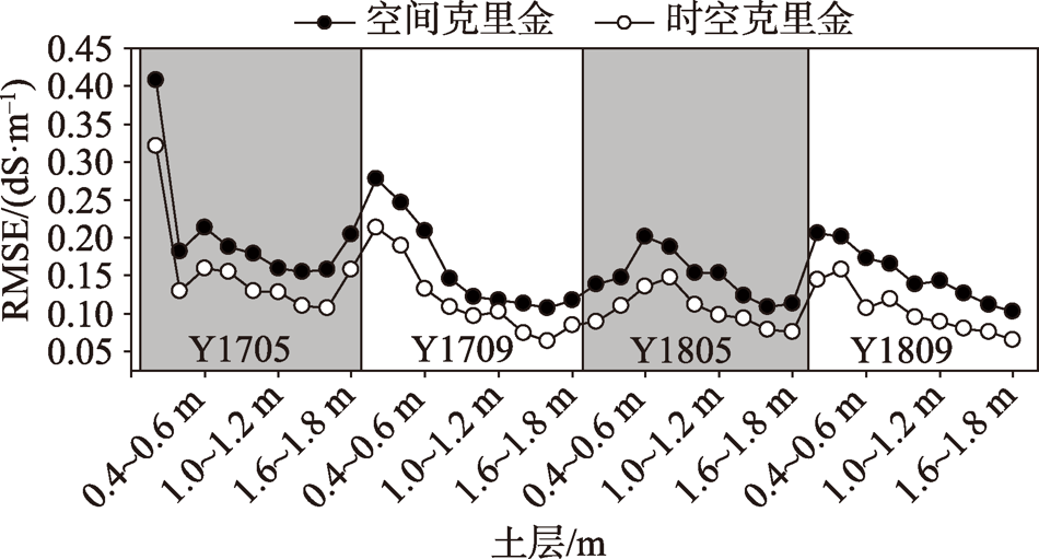
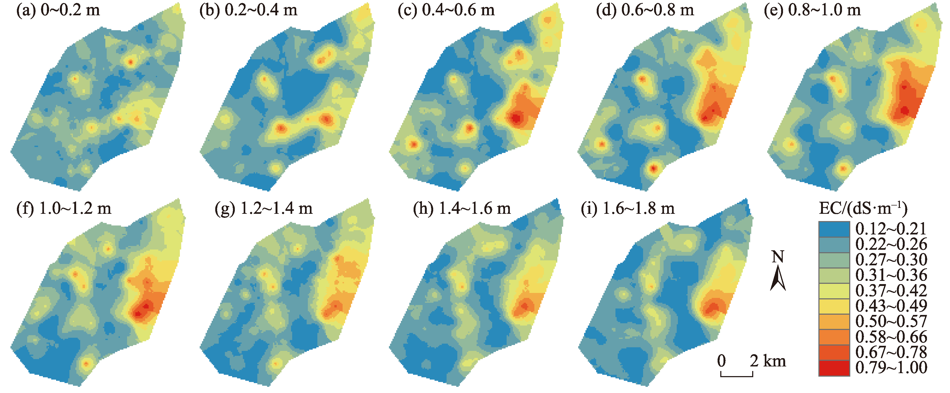
Fig. 5
Soil salinity maps of different soil layers within the depth 0-1.8 m in Y1805"
Tab. 3
Cross-validation results for 0-0.6 m and 0.6-1.2 m layer soil salinity with all soil salinity monitoring locations (ASML) and long-term soil salinity monitoring locations (LSML)"
| 土层/m | ASML | LSML | |||||
|---|---|---|---|---|---|---|---|
| MRE/% | RMSE/(dS·m-1) | R2 | MRE/% | RMSE/(dS·m-1) | R2 | ||
| 0~0.6 | 3.60 | 0.13 | 0.64 | 2.52 | 0.12 | 0.73 | |
| 0.6~1.2 | 3.11 | 0.10 | 0.65 | 2.54 | 0.09 | 0.70 | |
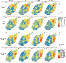
Fig. 6
The spatial distribution of root zone (within the depth of 0-0.6 m) and 0.6-1.2 m layer soil salinity determined by all soil salinity monitoring locations (ASML) and long-term soil salinity monitoring locations (LSML) at the 4 sampling times"

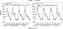
Fig. 7
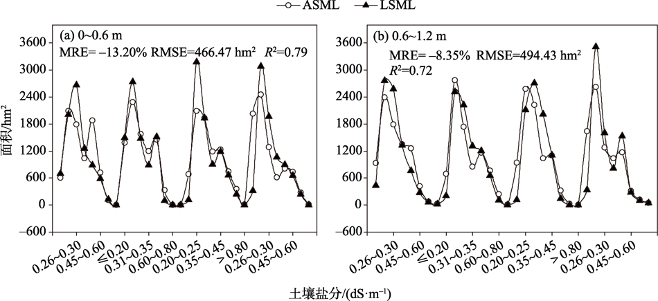
The area of different soil salinity determined by all soil salinity monitoring locations (ASML) and long-term soil salinity monitoring locations (LSML)"
Tab. 4
Comparison of ability of spatio-temporal Kriging and ordinary Kriging to obtain soil salinity dynamics under sparse monitoring locations"
| 土层/m | 时空克里金 | 普通克里金 | |||||
|---|---|---|---|---|---|---|---|
| MRE/% | RMSE/hm2 | R2 | MRE/% | RMSE/hm2 | R2 | ||
| 0~0.6 | -13.20 | 466.47 | 0.79 | 26.14 | 412.99 | 0.78 | |
| 0.6~1.2 | -8.35 | 494.43 | 0.72 | 120.09 | 731.13 | 0.48 | |
| [1] |
Sun G, Zhu Y, Ye M, et al. Development and application of long-term root zone salt balance model for predicting soil salinity in arid shallow water table area[J]. Agricultural Water Management, 2019, 213(3): 486-498.
doi: 10.1016/j.agwat.2018.10.043 |
| [2] | 史海滨, 杨树青, 李瑞平, 等. 内蒙古河套灌区节水灌溉与水肥高效利用研究展望[J]. 灌溉排水学报, 2020, 39(11): 1-12. |
| [Shi Haibin, Yang Shuqing, Li Ruiping, et al. Water-saving irrigation and utilization efficiency of water and fertilizer in Hetao Irrigation District of Inner Mongolia: Prospect for future research[J]. Journal of Irrigation and Drainage, 2020, 39(11): 1-12.] | |
| [3] |
Zheng Z, Zhang F, Ma F, et al. Identifying change in spatial accumulation of soil salinity in an inland river watershed, China[J]. Science of the Total Environment, 2018, 621: 177-185.
doi: 10.1016/j.scitotenv.2017.11.222 |
| [4] |
Zheng Z, Zhang F, Ma F, et al. Spatiotemporal changes in soil salinity in a drip-irrigated field[J]. Geoderma, 2009, 149: 243-248.
doi: 10.1016/j.geoderma.2008.12.002 |
| [5] | 徐英. 土壤水盐时空变异的稳健性分析和条件模拟研究[D]. 呼和浩特: 内蒙古农业大学, 2002. |
| [Xu Ying. Conditional Simulation and Robust Analysis of Time-space Variability of Soil Water and Salt[D]. Hohhot: Inner Mongolia Agricultural University, 2002.] | |
| [6] | 陈亚新, 徐英, 魏占民, 等. 基于稳健统计学的水盐空间变差函数逼近方法[J]. 水利学报, 2004, 35(9): 46-51. |
| [Chen Yaxin, Xu Ying, Wei Zhanmin, et al. Approximation method for spatial variogram of water and salinity in soil based on robust statistics[J]. Journal of Hydraulic Engineering, 2004, 35(9): 46-51.] | |
| [7] | 刘全明. 非参数统计与人工智能技术在水土空间变异中的应用研究[D]. 呼和浩特: 内蒙古农业大学, 2009. |
| [Liu Quanming. Application of Non-parametric Statistics and Artificial Intelligence Technology in Spatial Variability of Water and Soil[D]. Hohhot: Inner Mongolia Agricultural University, 2009.] | |
| [8] | 史海滨, 吴迪, 闫建文, 等. 盐渍化灌区节水改造后土壤盐分时空变化规律研究[J]. 农业机械学报, 2020, 51(2): 318-331. |
| [Shi Haibin, Wu Di, Yan Jianwen, et al. Spatial-temporal variation of soil salinity after water saving transformation in salinized Irrigation District[J]. Transactions of the Chinese Society for Agricultural Machinery, 2020, 51(2): 318-331.] | |
| [9] | 王瑞萍, 万核洋, 陈帅, 等. 河套灌区乌拉特灌域春季土壤盐碱化空间分布特征[J]. 农业工程学报, 2021, 37(15): 105-113. |
| [Wang Ruiping, Wan Heyang, Chen Shuai, et al. Spatial distribution pattern of soil salinization in farmland of Wulate sub-irrigation areas in Hetao Irrigation District in Inner Mongolia in spring[J]. Transactions of the Chinese Society of Agricultural Engineering (Transactions of the CSAE), 2021, 37(15): 105-113.] | |
| [10] |
Snepvangers J J J C, Heuvelink G B M, Huisman J A. Soil water content interpolation using spatio-temporal Kriging with external drift[J]. Geoderma, 2003, 112: 253-271.
doi: 10.1016/S0016-7061(02)00310-5 |
| [11] |
Hamzehpour N, Bogaert P. Improved spatiotemporal monitoring of soil salinity using filtered Kriging with measurement errors: An application to the West Urmia Lake, Iran[J]. Geoderma, 2017, 295: 22-33.
doi: 10.1016/j.geoderma.2017.02.004 |
| [12] |
Ruybal C J, Hoguel T S, McCray J E. Evaluation of Groundwater Levels in the Arapahoe Aquifer Using Spatiotemporal Regression Kriging[J]. Water Resources Research, 2019, 55: 2820-2837.
doi: 10.1029/2018WR023437 |
| [13] |
Bogaert P. Comparison of Kriging techniques in a space-time context[J]. Mathematical Geology, 1996, 28: 73-84.
doi: 10.1007/BF02273524 |
| [14] | Varouchakis E A, Hristopulos D T. Comparison of spatiotemporal variogram functions based on a sparse dataset of groundwater level variations[J]. Spatial Statistics, 2019, 34: 1-18. |
| [15] |
Gräler B, Pebesma E, Heuvelink G. Spatio-temporal interpolation using gstat[J]. The R Journal, 2016, 8: 204-218.
doi: 10.32614/RJ-2016-014 |
| [16] |
Hu H, Hu Z, Zhong K, et al. Satellite-based high-resolution mapping of ground-level PM2.5 concentrations over East China using a spatiotemporal regression Kriging model[J]. Science of The Total Environment, 2019, 672: 479-490.
doi: 10.1016/j.scitotenv.2019.03.480 |
| [17] |
Cressie N, Huang H C. Classes of nonseparable, Spatio-temporal stationary covariance functions[J]. Journal of the American Statistical Association, 1999, 94: 1330-1339.
doi: 10.1080/01621459.1999.10473885 |
| [18] |
Raja N B, Aydin O, Türkoğlu N, et al. Space-time Kriging of precipitation variability in Turkey for the period 1976-2010[J]. Theoretical and Applied Climatology, 2016, 129: 293-304.
doi: 10.1007/s00704-016-1788-8 |
| [19] |
Varouchakis E A, Theodoridou P G, Karatzas G P. Spatiotemporal geostatistical modeling of groundwater levels under a Bayesian framework using means of physical background[J]. Journal of Hydrology, 2019, 575: 487-498.
doi: 10.1016/j.jhydrol.2019.05.055 |
| [20] |
Yang Y, Wu J, Christakos G. Prediction of soil heavy metal distribution using spatiotemporal Kriging with trend model[J]. Ecological Indicators, 2015, 56: 125-133.
doi: 10.1016/j.ecolind.2015.03.034 |
| [21] |
Douaik A, Van Meirvenne M, Tóth T. Soil salinity mapping using spatio-temporal Kriging and Bayesian maximum entropy with interval soft data[J]. Geoderma, 2005, 128: 234-248.
doi: 10.1016/j.geoderma.2005.04.006 |
| [22] |
Gasch C K, Hengl T, Gräler B, et al. Spatio-temporal interpolation of soil water, temperature, and electrical conductivity in 3D + T: The Cook Agronomy Farm data set[J]. Spatial Statistics, 2015, 14: 70-90.
doi: 10.1016/j.spasta.2015.04.001 |
| [23] | 孙贯芳. 干旱区多尺度土壤盐分动态及长期均衡模型研究[D]. 武汉: 武汉大学, 2020. |
| [Sun Guanfang. Study on Soil Salinity Dynamics at Multiple Scales and Long-term Solute Balance Models in Arid Area[D]. Wuhan: Wuhan University, 2020.] | |
| [24] |
Sun G, Zhu Y, Ye M, et al. Regional soil salinity spatiotemporal dynamics and improved temporal stability analysis in arid agricultural areas[J]. Journal of Soils and Sediments, 2022, 22: 272-292.
doi: 10.1007/s11368-021-03074-y |
| [25] | 张仁铎. 空间变异理论及应用[M]. 北京: 科学出版社, 2005: 27-31. |
| [Zhang Renduo. Spatial Variation Theory and Its Application[M]. Beijing: Science Press, 2005: 27-31.] | |
| [26] |
Hu W, Shao M, Han F, et al. Watershed scale temporal stability of soil water content[J]. Geoderma, 2010, 158: 181-198.
doi: 10.1016/j.geoderma.2010.04.030 |
| [27] | 杨勇, 梅杨, 张楚天, 等. 基于时空克里格的土壤重金属时空建模与预测[J]. 农业工程学报, 2014, 30(21): 249-255. |
| [Yang Yong, Mei Yang, Zhang Chutian, et al. Spatio-temporal modeling and prediction of soil heavy metal based on spatio-temporal Kriging[J]. Transactions of the Chinese Society of Agricultural Engineering (Transactions of the CSAE), 2014, 30(21): 249-255.] | |
| [28] | 雷志栋, 杨诗秀, 谢森传. 土壤水动力学[M]. 北京: 清华大学出版社, 1988: 334-337. |
| [Lei Zhidong, Yang Shixiu, Xie Senchuan. Soil Hydrodynamics[M]. Beijing: Tsinghua University Press, 1988: 334-337.] | |
| [29] | 梅杨. 时空克里格方法关键技术及其应用研究[D]. 武汉: 华中农业大学, 2016. |
| [Mei Yang. Key Technology and Its Application for Spatio-temporal Kriging[D]. Wuhan: Huazhong Agricultural University, 2016.] | |
| [30] | 孙贯芳, 屈忠义, 杜斌, 等. 不同灌溉制度下河套灌区玉米膜下滴灌水热盐运移规律[J]. 农业工程学报, 2017, 33(12): 144-152. |
| [Sun Guanfang, Qu Zhongyi, Du Bin, et al. Water-heat-salt effects of mulched drip irrigation maize with different irrigation scheduling in Hetao Irrigation District[J]. Transactions of the Chinese Society of Agricultural Engineering (Transactions of the CSAE), 2017, 33(12): 144-152.] | |
| [31] |
Yang Y, Christakos G, Yang X, et al. Spatiotemporal characterization and mapping of PM2.5 concentrations in southern Jiangsu Province, China[J]. Environmental Pollution, 2018, 234: 794-803.
doi: 10.1016/j.envpol.2017.11.077 |
|
||