Arid Zone Research ›› 2021, Vol. 38 ›› Issue (5): 1464-1473.doi: 10.13866/j.azr.2021.05.29
• Ecology and Environment • Previous Articles Next Articles
CHEN Zhenqi1( ),ZHANG Jing1,2(),ZHANG Yilong1,LIU Rui1
Received:2021-03-16
Revised:2021-06-03
Online:2021-09-15
Published:2021-09-24
Contact:
Jing ZHANG
E-mail:1051373495@qq.com;zhangjing@dlnu.edu.cn
CHEN Zhenqi,ZHANG Jing,ZHANG Yilong,LIU Rui. Spatio-temporal patterns variation of ecological vulnerability in Otindag Sandy Land based on a vulnerability scoping diagram[J].Arid Zone Research, 2021, 38(5): 1464-1473.
Add to citation manager EndNote|Reference Manager|ProCite|BibTeX|RefWorks
Tab. 1
The ecological vulnerability evaluation indices system and weight"
| 目标层(权重) | 要素层(权重) | 指标层a | 指标方向 | 指标权重 |
|---|---|---|---|---|
| 暴露度 (0.4934) | B1人口社会压力 (0.2470) | 人口密度/(人·km-2) | + | 0.0384 |
| 人均草地面积/(km2·人-1) | - | 0.0488 | ||
| 牲畜数量/(头·km-2) | + | 0.1598 | ||
| B2干旱灾害 (0.2465) | 地温/℃ | + | 0.0156 | |
| 年降水变化率/(mm·a-1) | + | 0.1027 | ||
| 生长季降水间隔/d | + | 0.1112 | ||
| 极端最高温天数/d | + | 0.0170 | ||
| 敏感性 (0.3108) | B3植被覆盖 (0.1726) | NDVI | - | 0.0940 |
| 景观多样性 | - | 0.0245 | ||
| 景观破碎度 | + | 0.0541 | ||
| B4气候 (0.1382) | 年均降水量/mm | - | 0.1382 | |
| 适应能力 (0.1958) | B5自我调节 (0.1958) | NPP/(g·m-2·a-1) | - | 0.1305 |
| NDVI变化率 | + | 0.0653 |
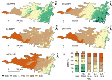
Fig. 1
The spatial distribution of ecological vulnerability in Otindag Sandy Land from 2000 to 2019"
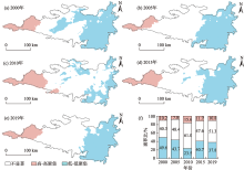
Fig. 2
Moran’s I cluster diagram of ecological vulnerability of Otindag Sandy Land from 2000 to 2019"

Tab. 2
Ecological vulnerability index of different land use types from 2000 to 2019"
| 土地利用类型(2019年面积比) | 2000年 | 2005年 | 2010年 | 2015年 | 2019年 | 平均值 |
|---|---|---|---|---|---|---|
| 耕地(3.18%) | 0.377 | 0.356 | 0.447 | 0.424 | 0.425 | 0.406 |
| 林地(0.83%) | 0.375 | 0.363 | 0.430 | 0.413 | 0.419 | 0.400 |
| 草地(77.96%) | 0.407 | 0.412 | 0.469 | 0.463 | 0.498 | 0.450 |
| 水域(1.69%) | 0.419 | 0.437 | 0.482 | 0.470 | 0.521 | 0.466 |
| 居民工矿用地(0.31%) | 0.386 | 0.371 | 0.455 | 0.435 | 0.446 | 0.419 |
| 未利用土地(16.03%) | 0.410 | 0.417 | 0.472 | 0.469 | 0.508 | 0.455 |
Tab. 3
The load matrix of principal components from 2000 to 2019"
| 评价指标 | 2000年 | 2005年 | 2010年 | 2015年 | 2019年 | |||||
|---|---|---|---|---|---|---|---|---|---|---|
| PC1 | PC2 | PC1 | PC2 | PC1 | PC2 | PC1 | PC2 | PC1 | PC2 | |
| 人口密度 | 0.76 | 0.77 | ||||||||
| 人均草地面积 | 0.86 | 0.71 | ||||||||
| 牲畜数量 | 0.84 | 0.90 | 0.81 | |||||||
| 地温 | 0.79 | 0.77 | 0.81 | 0.80 | ||||||
| 年降水变化率 | 0.90 | 0.91 | ||||||||
| 生长季降水间隔 | 0.92 | 0.93 | 0.89 | 0.93 | 0.94 | |||||
| 极端最高温天数 | 0.84 | 0.92 | 0.87 | 0.82 | ||||||
| NDVI | 0.83 | 0.84 | 0.85 | 0.87 | 0.85 | |||||
| 景观多样性 | -0.71 | -0.79 | ||||||||
| 景观破碎度 | ||||||||||
| 年均降水 | 0.96 | 0.96 | 0.96 | 0.95 | 0.95 | |||||
| NPP | 0.88 | 0.85 | 0.87 | 0.83 | ||||||
| NDVI变化率 | ||||||||||
| 贡献率/% | 51.62 | 10.46 | 59.33 | 9.76 | 54.14 | 10.94 | 53.73 | 10.74 | 53.86 | 11.01 |
| [1] |
李永化, 范强, 王雪, 等. 基于SRP模型的自然灾害多发区生态脆弱性时空分异研究——以辽宁省朝阳县为例[J]. 地理科学, 2015, 35(11): 1452-1459.
doi: 10.13249/j.cnki.sgs.2015.011.1452 |
|
[ Li Yonghua, Fan Qiang, Wang Xue, et al. Spatial and temporal differentiation of ecological vulnerability under the frequency of natural hazard based on SRP Model: A case study in Chaoyang County[J]. Scientia Geographica Sinica, 2015, 35(11): 1452-1459. ]
doi: 10.13249/j.cnki.sgs.2015.011.1452 |
|
| [2] |
Shao H, Liu M, Shao Q, et al. Research on eco-environmental vulnerability evaluation of the Anning River Basin in the upper reaches of the Yangtze River[J]. Environmental Earth Sciences, 2014, 72(5): 1555-1568.
doi: 10.1007/s12665-014-3060-9 |
| [3] | Lavorel S, Flannigan M D, Lambin E F, et al. Vulnerability of land systems to fire: Interactions among humans, climate, the atmosphere, and ecosystems[J]. Mitigation & Adaptation Strategies for Global Change, 2007, 12(1): 33-53. |
| [4] |
Guo B, Zang W, Luo W. Spatial-temporal shifts of ecological vulnerability of Karst Mountain ecosystem-impacts of global change and anthropogenic interference[J]. Science of The Total Environment, 2020, 741: 140256.
doi: 10.1016/j.scitotenv.2020.140256 |
| [5] | Williams L R R, Kapustka L A. Ecosystem vulnerability: A complex interface with technical components[J]. Environmental Toxicology and Chemistry, 2000, 19(4): 1055-1058. |
| [6] | 马子惠, 马书明, 张树深. 大连市生态脆弱性评价及其不确定性分析[J]. 水土保持通报, 2019, 39(3): 237-242. |
| [ Ma Zihui, Ma Shuming, Zhang Shushen. Ecological vulnerability assessment and its uncertainty analysis of Dalian City[J]. Bulletin of Soil and Water Conservation, 2019, 39(3): 237-242. ] | |
| [7] | 马一丁, 付晓, 田野, 等. 锡林郭勒盟煤电基地开发生态脆弱性评价[J]. 生态学报, 2017, 37(13): 4505-4510. |
| [ Ma Yiding, Fu Xiao, Tian Ye, et al. Analysis of the ecological vulnerability of the coal-electricity base area in Xilinguole League[J]. Acta Ecologica Sinica, 2017, 37(13): 4505-4510. ] | |
| [8] |
朱琪, 周旺明, 贾翔, 等. 长白山国家自然保护区及其周边地区生态脆弱性评估[J]. 应用生态学报, 2019, 30(5): 1633-1641.
doi: 10.13287/j.1001-9332.201905.030 pmid: 31107020 |
|
[ Zhu Qi, Zhou Wangming, Jia Xiang, et al. Ecological vulnerability assessment on Changbai Mountain National Nature Reserve and its surrounding areas, Northeast China[J]. Chinese Journal of Applied Ecology, 2019, 30(5): 1633-1641. ]
doi: 10.13287/j.1001-9332.201905.030 pmid: 31107020 |
|
| [9] | 封建民, 郭玲霞, 李晓华. 基于景观格局的榆阳区生态脆弱性评价[J]. 水土保持研究, 2016, 23(6): 179-184. |
| [ Feng Jianmin, Guo Lingxia, Li Xiaohua. Analysis of ecological vulnerability in Yuyang District based on landscape pattern[J]. Research of Soil and Water Conservation, 2016, 23(6): 179-184. ] | |
| [10] | 王介勇, 赵庚星, 杜春先. 基于景观空间结构信息的区域生态脆弱性分析——以黄河三角洲垦利县为例[J]. 干旱区研究, 2005, 22(3): 317-321. |
| [ Wang Jieyong, Zhao Gengxing, Du Chunxian. Analysis on the regional ecological environment vulnerability based on the information of spatial structure of landscapes: A case study in Kenli Country located in the Yellow River Delta[J]. Arid Zone Research, 2005, 22(3): 317-321. ] | |
| [11] | 蒋友严, 韩涛, 王有恒, 等. 石羊河调水10 a来民勤绿洲生态脆弱性变化[J]. 干旱区研究, 2014, 31(1): 157-162. |
| [ Jiang Youyan, Han Tao, Wang Youheng, et al. Change of ecological vulnerability in the Minqin Oasis since diversion of the Shiyang River Basin in 10 years[J]. Arid Zone Research, 2014, 31(1): 157-162. ] | |
| [12] | 陶希东, 赵鸿婕. 河西走廊生态脆弱性评价及其恢复与重建[J]. 干旱区研究, 2002, 19(4): 7-12. |
| [ Tao Xidong, Zhao Hongjie. Study on the vulnerability assessment, restoration and regeneration of the ecology in the Hexi Corridor[J]. Arid Zone Research, 2002, 19(4): 7-12. ] | |
| [13] |
Zang Z, Zou X, Zuo P, et al. Impact of landscape patterns on ecological vulnerability and ecosystem service values: An empirical analysis of Yancheng Nature Reserve in China[J]. Ecological Indicators, 2017, 72: 142-152.
doi: 10.1016/j.ecolind.2016.08.019 |
| [14] | Okey T A, Agbayani S, Alidina H M. Mapping ecological vulnerability to recent climate change in Canada’s Pacific marine ecosystems[J]. Ocean & Coastal Management, 2015, 106: 35-48. |
| [15] |
Jiang L, Huang X, Wang F, et al. Method for evaluating ecological vulnerability under climate change based on remote sensing: A case study[J]. Ecological Indicators, 2018, 85: 479-486.
doi: 10.1016/j.ecolind.2017.10.044 |
| [16] | 周梦云, 蔡永立, 张瑞峰, 等. 宁夏贺兰山国家级自然保护区建立前后区域生态脆弱性时空格局变化研究[J]. 生态科学, 2019, 38(5): 78-85. |
| [ Zhou Mengyun, Cai Yongli, Zhang Ruifeng, et al. The tempo-spatial pattern of regional ecological vulnerability before and after the establishment of National Nature Reserve in Helan Mountain of Ningxia[J]. Ecological Science, 2019, 38(5): 78-85. ] | |
| [17] | 张莹, 张学玲, 蔡海生. 基于地理探测器的江西省万安县生态脆弱性时空演变及驱动力分析[J]. 水土保持通报, 2018, 38(4): 207-214. |
| [ Zhang Ying, Zhang Xueling, Cai Haisheng. Temporal and spatial evolutions and its driving factors of ecological vulnerability in Wan’an County of Jiangxi Province based on geogdetector[J]. Bulletin of Soil and Water Conservation, 2018, 38(4): 207-214. ] | |
| [18] |
Zhang F, Liu X, Zhang J, et al. Ecological vulnerability assessment based on multi-sources data and SD model in Yinma River Basin, China[J]. Ecological Modelling, 2017, 349: 41-50.
doi: 10.1016/j.ecolmodel.2017.01.016 |
| [19] |
Polsky C, Neff R, Yarnal B. Building comparable global change vulnerability assessments: The vulnerability scoping diagram[J]. Global Environmental Change, 2007, 17: 472-485.
doi: 10.1016/j.gloenvcha.2007.01.005 |
| [20] | 杨俊, 关莹莹, 李雪铭, 等. 城市边缘区生态脆弱性时空演变——以大连市甘井子区为例[J]. 生态学报, 2018, 38(7): 778-787. |
| [ Yang Jun, Guan Yingying, Li Xueming, et al. Urban fringe area ecological vulnerability space-time evolution research: the case of Ganjingzi District, Dalian[J]. Acta Ecologica Sinica, 2018, 38(3): 778-787. ] | |
| [21] |
张金茜, 李红瑛, 曹二佳, 等. 多尺度流域生态脆弱性评价及其空间关联性——以甘肃白龙江流域为例[J]. 应用生态学报, 2018, 29(9): 2897-2906.
doi: 10.13287/j.1001-9332.201809.008 pmid: 30411565 |
|
[ Zhang Jinxi, Li Hongying, Cao Erjia, et al. Assessment of ecological vulnerability in multi-scale and its spatial correlation: A case study of Bailongjiang Watershed in Gansu Province, China[J]. Chinese Journal of Applied Ecology, 2018, 29(9): 2897-2906. ]
doi: 10.13287/j.1001-9332.201809.008 pmid: 30411565 |
|
| [22] | 李平星, 陈诚. 基于VSD模型的经济发达地区生态脆弱性评价——以太湖流域为例[J]. 生态环境学报, 2014, 23(2): 237-243. |
| [ Li Pingxing, Chen Cheng. Ecological vulnerability assessment of economic developed region based on VSD model: The case of Taihu basin[J]. Ecology and Environmental Sciences, 2014, 23(2): 237-243. ] | |
| [23] | 梁二敏, 张军民, 杨卫红. 新疆玛纳斯河流域绿洲景观生态脆弱性时空分异[J]. 干旱区研究, 2017, 34(4): 950-957. |
| [ Liang Ermin, Zhang Junmin, Yang Weihong. Spatiotemporal variation of landscape ecological vulnerability in Oasis in the Manas River Basin, Xinjiang[J]. Arid Zone Research, 2017, 34(4): 950-957. ] | |
| [24] |
Peng B, Huang Q, Elahi E, et al. Ecological environment vulnerability and driving force of Yangtze River urban agglomeration[J]. Sustainability, 2019, 11(23): 6623.
doi: 10.3390/su11236623 |
| [25] |
Li R, Han R, Yu Q, et al. Spatial heterogeneous of ecological vulnerability in arid and semi-arid area: A case of the Ningxia Hui Autonomous Region, China[J]. Sustainability, 2020, 12: 4401.
doi: 10.3390/su12114401 |
| [26] | 王贝贝, 丁明军, 管琪卉, 等. 基于格网的南昌市生态环境脆弱性评价[J]. 生态学报, 2019, 39(15): 5460-5472. |
| [ Wang Beibei, Ding Mingjun, Guan Qihui, et al. Gridded assessment of eco-environmental vulnerability in Nanchang city[J]. Acta Ecologica Sinica, 2019, 39(15): 5460-5472. ] | |
| [27] | 郭泽呈, 魏伟, 庞素菲, 等. 基于SPCA和遥感指数的干旱内陆河流域生态脆弱性时空演变及动因分析——以石羊河流域为例[J]. 生态学报, 2019, 39(7): 2558-2572. |
| [ Guo Zecheng, Pang Sufei, et al. Spatio-temporal evolution and motivation analysis of ecological vulnerability in Arid Inland River Basin based on SPCA and remote sensing index: A case study on the Shiyang River Basin[J]. Acta Ecologica Sinica, 2019, 39(7): 2558-2572. ] | |
| [28] | 张行, 陈海, 史琴琴, 等. 陕西省景观生态脆弱性时空演变及其影响因素[J]. 干旱区研究, 2020, 37(2): 496-505. |
| [ Zhang Hang, Chen Hai, Shi Qinqin, et al. Spatiotemporal evolution and driving factors of landscape ecological vulnerability in Shaanxi Province[J]. Arid Zone Research, 2020, 37(2): 496-505. ] | |
| [29] |
Zhao Y, Chi W, Kuang W, et al. Ecological and environmental consequences of ecological projects in the Beijing-Tianjin sand source region[J]. Ecological Indicators, 2020, 112: 106111.
doi: 10.1016/j.ecolind.2020.106111 |
| [30] | 武洁, 史明昌, 丁国栋. 浑善达克沙地正蓝旗沙漠化时空格局[J]. 中国水土保持科学, 2019, 17(5): 110-119. |
| [ Wu Jie, Shi Mingchang, Ding Guodong. On the spatio-temporal pattern of desertification in Zhenglan banner, Hunshandake sandy land[J]. Science of Soil and Water Conservation, 2019, 17(5): 110-119. ] | |
| [31] |
Yang X, Scuderi L, Wang X, et al. Groundwater sapping as the cause of irreversible desertification of Hunshandake Sandy Lands, Inner Mongolia, northern China[J]. Proceedings of the National Academy of Sciences of the United States of America, 2015: doi: 10.1073/pnas.1418090112.
doi: 10.1073/pnas.1418090112 |
| [32] | 赵媛媛, 武海岩, 丁国栋, 等. 浑善达克沙地土地沙漠化研究进展[J]. 中国沙漠, 2020, 40(5): 102-112. |
| [ Zhao Yuanyuan, Wu Haiyan, Ding Guodong, et al. A review on the aeolian desertification in the Otindag Sandy Land[J]. Journal of Desert Research, 2020, 40(5): 102-112. ] | |
| [33] | 刘洋, 李诚志, 刘志辉, 等. 1982—2013年基于GIMMS-NDVI的新疆植被覆盖时空变化[J]. 生态学报, 2016, 36(19): 6198-6208. |
| [ Liu Yang, Li Chengzhi, Liu Zhihui, et al. Assessment of spatio-temporal variations in vegetation cover in Xinjiang from 1982 to 2013 based on GIMMS-NDVI[J]. Acta Ecologica Sinica, 2016, 36(19): 6198-6208. ] | |
| [34] | 朱文泉. 中国陆地生态系统植被净初级生产力遥感估算及其与气候变化关系的研究[D]. 北京: 北京师范大学, 2005. |
| [ Zhu Wenquan.Remote Sensing Estimation of Net Primary Productivity of Terrestrial Ecosystem Vegetation in China and Its Relationship with Climate Change[D]. Beijing: Beijing Normal University, 2005. ] | |
| [35] | Allen R G, Pereira L S, Raes D, et al. Crop Evapotranspiration-Guidelines for Computing Crop Water Requirements-FAO Irrigation and Drainage Paper 56[M]. Rome: FAO-Food and Agriculture Organization of the United Nations, 1998. |
| [36] |
Zhang J, Li X, Buyantuev A, et al. How do trade-offs and synergies between ecosystem services change in the long period? The case study of Uxin, Inner Mongolia, China[J]. Sustainability, 2019, 11(21): 6041.
doi: 10.3390/su11216041 |
| [37] | Tabachnick B G, Fidell L S. Using Multivariate Statistics[M]. 5th Edition. Needham Heights, M A: Allyn & Bacon, 2007. |
| [38] | 吴明隆. 问卷统计分析实务——SPSS操作与应用[M]. 重庆: 重庆大学出版社, 2010. |
| [ Wu Minglong. Practice of Statistical Analysis of Questionnaires-Operation and Application of SPSS[M]. Chongqing: Chongqing University Press, 2010. ] | |
| [39] | 姚雪玲, 李龙, 王锋, 等. 放牧方式对浑善达克沙地榆树疏林退化的影响[J]. 生态学报, 2020, 40(5): 1663-1671. |
| [ Yao Xueling, Li Long, Wang Feng, et al. Effects of grazing management on the degradation of Ulmus pumila open forest in Otindag Sandy Land[J]. Acta Ecologica Sinica, 2020, 40(5): 1663-1671. ] | |
| [40] |
Lyu Y, Fu B, Feng X, et al. A policy-driven large scale ecological restoration: Quantifying ecosystem services changes in the Loess Plateau of China[J]. PLOS One, 2012, 7(2): e31782.
doi: 10.1371/journal.pone.0031782 |
| [41] |
徐超璇, 鲁春霞, 黄绍琳. 张家口地区生态脆弱性及其影响因素[J]. 自然资源学报, 2020, 35(6): 1288-1300.
doi: 10.31497/zrzyxb.20200603 |
|
[ Xu Chaoxuan, Lu Chunxia, Huang Shaolin. Study on ecological vulnerability and its influencing factors in Zhangjiakou area[J]. Journal of Natural Resources, 2020, 35(6): 1288-1300. ]
doi: 10.31497/zrzyxb.20200603 |
|
| [42] |
Lyu X, Xiao W, Zhao Y, et al. Drivers of spatio-temporal ecological vulnerability in an arid, coal mining region in Western China[J]. Ecological Indicators, 2019, 106: 105475.
doi: 10.1016/j.ecolind.2019.105475 |
| [43] |
史娜娜, 肖能文, 王琦, 等. 锡林郭勒植被NDVI时空变化及其驱动力定量分析[J]. 植物生态学报, 2019, 43(4): 331-341.
doi: 10.17521/cjpe.2018.0254 |
|
[ Shi Nana, Xiao Nengwen, Wang Qi, et al. Spatio-temporal dynamics of normalized differential vegetation index and its driving factors in Xilin Gol, China[J]. Chinese Journal of Plant Ecology, 2019, 43(4): 331-341. ]
doi: 10.17521/cjpe.2018.0254 |
|
| [44] | 姜晓群, 林哲艳, 时钰, 等. 美国公共放牧地管理政策演进的历史经验[J]. 草业学报, 2020, 29(11): 14. |
| [ Jiang Xiaoqun, Lin Zheyan, Shi Yu, et al. Historic experience from American public range land management policies[J]. Acta Prataculturae Sinica, 2020, 29(11): 14. ] | |
| [45] |
Zhang J, Niu J, Buyantuev A, et al. A multilevel analysis of effects of land use policy on land-cover change and local land use decisions[J]. Journal of Arid Environments, 2014, 108: 19-28.
doi: 10.1016/j.jaridenv.2014.04.006 |
| [46] | 孙特生, 包亚琴, 李文彦. 基于草地资源可持续利用的干旱半干旱区草牧业发展策略———以新疆阿勒泰地区为例[J]. 生态学杂志, 2020, 39(10): 3509-3520. |
| [ Sun Tesheng, Bao Yaqin, Li Wenyan. Strategy on the development of grass-based livestock husbandry in the arid and semi-arid region based on sustainable utilization of grassland resources: A case study of Altay, Xinjiang, China[J]. Chinese Journal of Ecology, 2020, 39(10): 3509-3520. ] |
|
||