Arid Zone Research ›› 2022, Vol. 39 ›› Issue (4): 1259-1269.doi: 10.13866/j.azr.2022.04.26
• Ecology and Environment • Previous Articles Next Articles
ZHANG Yunxia1( ),ZHANG Jinxi1,2,GONG Jie1()
Received:2022-01-26
Revised:2022-03-04
Online:2022-07-15
Published:2022-09-26
Contact:
Jie GONG
E-mail:zhangyunxia20@lzu.edu.cn;jgong@lzu.edu.cn
ZHANG Yunxia,ZHANG Jinxi,GONG Jie. Landscape pattern vulnerability and its influencing factors on a semi-arid lake basin: A case study of Liangcheng County[J].Arid Zone Research, 2022, 39(4): 1259-1269.
Add to citation manager EndNote|Reference Manager|ProCite|BibTeX|RefWorks

Fig. 1
Location of the study area"


Fig. 2
Spatial distribution of landscape types in Liangcheng Country from 1980 to 2020"
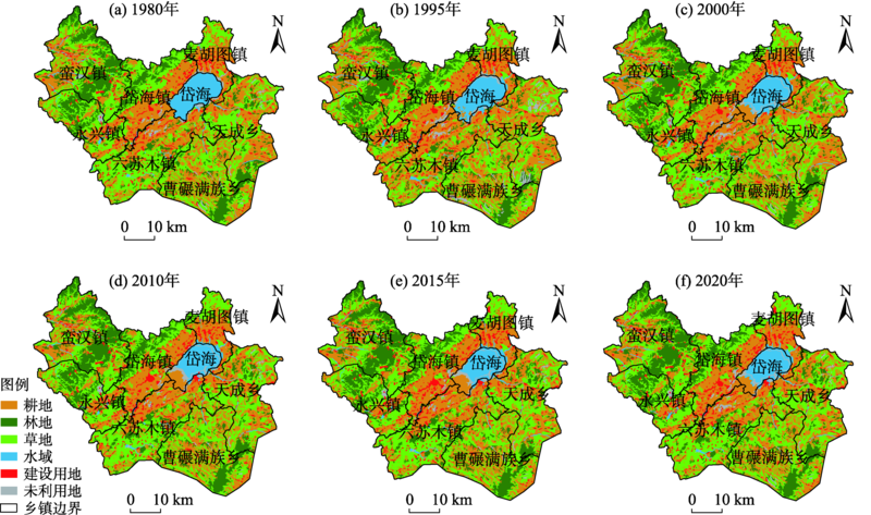
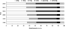
Fig. 3
Area proportion of various landscape types in Liangcheng Country from 1980 to 2020"

Fig. 4
Single landscape type dynamic degree in Liangcheng Country from 1980 to 2020"
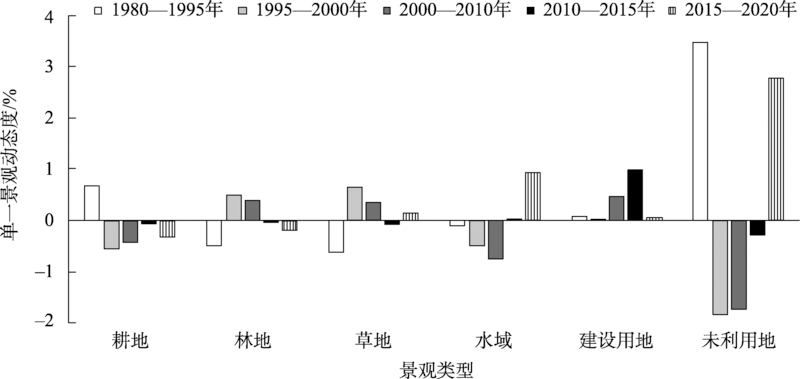

Fig. 5
Continuous spatial distribution of landscape vulnerability index in Liangcheng Country from 1980 to 2020"

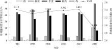
Fig. 6
Proportion of landscape pattern vulnerability level and LVII in Liangcheng Country from 1980 to 2020"

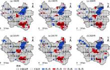
Fig. 7
Lisa aggregation map of landscape vulnerability index in Liangcheng Country from 1980 to 2020"

Tab. 1
Basic statistics of LVI of various landscape types in Liangcheng County from 1980 to 2020"
| 耕地 | 林地 | 草地 | 水域 | 建设用地 | 未利用地 | ||||||||||||
|---|---|---|---|---|---|---|---|---|---|---|---|---|---|---|---|---|---|
| 最小值 | 最大值 | 最小值 | 最大值 | 最小值 | 最大值 | 最小值 | 最大值 | 最小值 | 最大值 | 最小值 | 最大值 | ||||||
| 1980年 | 0.122 | 0.721 | 0.167 | 0.639 | 0.135 | 0.721 | 0.037 | 0.500 | 0.176 | 0.699 | 0.184 | 0.595 | |||||
| 1995年 | 0.048 | 0.936 | 0.040 | 0.747 | 0.073 | 0.865 | 0.039 | 0.530 | 0.126 | 0.902 | 0.158 | 0.690 | |||||
| 2000年 | 0.072 | 0.728 | 0.054 | 0.622 | 0.126 | 0.644 | 0.061 | 0.476 | 0.154 | 0.686 | 0.203 | 0.551 | |||||
| 2010年 | 0.086 | 0.905 | 0.094 | 0.805 | 0.108 | 0.718 | 0.049 | 0.524 | 0.141 | 0.736 | 0.208 | 0.599 | |||||
| 2015年 | 0.115 | 0.836 | 0.106 | 0.709 | 0.141 | 0.703 | 0.056 | 0.506 | 0.144 | 0.745 | 0.227 | 0.565 | |||||
| 2020年 | 0.053 | 0.522 | 0.197 | 0.540 | 0.206 | 0.590 | 0.110 | 0.443 | 0.108 | 0.494 | 0.178 | 0.580 | |||||
| 变化 | 0.693 | 0.567 | 0.575 | 0.438 | 0.569 | 0.404 | |||||||||||
Tab. 2
LVII of various landscape types in Liangcheng County from 1980 to 2020"
| 耕地 | 林地 | 草地 | 水域 | 建设用地 | 未利用地 | |
|---|---|---|---|---|---|---|
| 1980年 | 3.473 | 3.534 | 3.551 | 1.963 | 3.250 | 3.135 |
| 1995年 | 3.303 | 3.543 | 3.426 | 2.192 | 3.056 | 3.303 |
| 2000年 | 3.371 | 3.505 | 3.475 | 2.337 | 3.118 | 3.286 |
| 2010年 | 3.383 | 3.540 | 3.524 | 2.261 | 3.092 | 3.251 |
| 2015年 | 3.400 | 3.536 | 3.540 | 2.322 | 3.194 | 3.307 |
| 2020年 | 3.001 | 2.901 | 3.035 | 1.879 | 2.769 | 2.896 |
| 多年平均 | 3.322 | 3.427 | 3.425 | 2.159 | 3.080 | 3.196 |
Tab. 3
LVII on different altitudes and slopes in different levels in Liangcheng Country"
| Ⅰ | Ⅱ | Ⅲ | Ⅳ | Ⅴ | ||||||||||
|---|---|---|---|---|---|---|---|---|---|---|---|---|---|---|
| 低海拔 | 平坡 | 较低海拔 | 缓坡 | 中等海拔 | 斜坡 | 较高海拔 | 陡坡 | 高海拔 | 急坡 | |||||
| <1300 m | <5° | 1300~1500 m | 5°~15° | 1500~1700 m | 15~25° | 1700~1900 m | 25°~40° | >1900 m | >40° | |||||
| 1980年 | 2.963 | 3.224 | 3.380 | 3.512 | 3.742 | 3.593 | 3.791 | 3.603 | 3.490 | 3.486 | ||||
| 1995年 | 2.868 | 3.126 | 3.218 | 3.381 | 3.640 | 3.558 | 3.817 | 3.611 | 3.532 | 3.497 | ||||
| 2000年 | 2.968 | 3.204 | 3.308 | 3.437 | 3.657 | 3.557 | 3.782 | 3.582 | 3.440 | 3.503 | ||||
| 2010年 | 2.993 | 3.213 | 3.331 | 3.473 | 3.710 | 3.604 | 3.775 | 3.628 | 3.438 | 3.548 | ||||
| 2015年 | 3.044 | 3.245 | 3.358 | 3.489 | 3.704 | 3.604 | 3.776 | 3.617 | 3.444 | 3.542 | ||||
| 2020年 | 2.632 | 2.824 | 2.948 | 3.005 | 3.127 | 2.978 | 3.133 | 2.916 | 2.733 | 2.805 | ||||
| 多年平均 | 2.912 | 3.139 | 3.257 | 3.383 | 3.597 | 3.483 | 3.679 | 3.493 | 3.346 | 3.397 | ||||
| [1] | 孙鸿超, 张正祥. 吉林省松花江流域景观格局脆弱性变化及其驱动力[J]. 干旱区研究, 2019, 36(4): 1005-1014. |
| [Sun Hongchao, Zhang Zhengxiang. Change of landscape pattern vulnerability in the Songhua River Basin in Jilin Province and its driving forces[J]. Arid Zone Research, 2019, 36(4): 1005-1014.] | |
| [2] |
Peters M K, Hemp A, Appelhans T, et al. Climate-land-use interactions shape tropical mountain biodiversity and ecosystem functions[J]. Nature, 2019, 568(7750): 88-92.
doi: 10.1038/s41586-019-1048-z |
| [3] |
Mekonnen M M, Hoekstra A Y. Four billion people facing severe water scarcity[J]. Science Advances, 2016, 2(2): e1500323.
doi: 10.1126/sciadv.1500323 |
| [4] |
Corey L, Pedram R, Navin R. Influence of extreme weather disasters on global crop production[J]. Nature, 2016, 529(7584): 84-87.
doi: 10.1038/nature16467 |
| [5] |
Gideon B, Hirotaka M. A perception-based estimation of the ecological impacts of livelihood activities: The case of rural Ghana[J]. Ecological Indicators, 2018, 93(10): 424-433.
doi: 10.1016/j.ecolind.2018.04.074 |
| [6] |
Polsky C, Neff R, Yarnal B. Building comparable global change vulnerability assessments: The vulnerability scoping diagram[J]. Global Environmental Change, 2007, 17(3): 472-485.
doi: 10.1016/j.gloenvcha.2007.01.005 |
| [7] | 李鹤, 张平宇. 全球变化背景下脆弱性研究进展与应用展望[J]. 地理科学进展, 2011, 30(7): 920-929. |
| [Li He, Zhang Pingyu. Research progress and prospective applications of vulnerability approach under global change[J]. Progress in Geography, 2011, 30(7): 920-929.] | |
| [8] | 王让会, 赵文斐, 彭擎, 等. 气候变化及景观格局与生态系统碳储存的耦合关系——以祁连山为例[J]. 干旱区研究, 2022, 39(1): 250-257. |
| [Wang Ranghui, Zhao Wenfei, Peng Qing, et al. The relationship of climate change and landscape pattern with ecosystem carbon storage: A case study from the Qilian Mountains[J]. Arid Zone Research, 2022, 39(1): 250-257.] | |
| [9] |
Javed M, Hussein A W, Atiqur R, et al. Landscape dynamic characteristics using satellite data for a mountainous watershed of Abha, Kingdom of Saudi Arabia[J]. Environmental Earth Sciences, 2015, 72(12): 4973-4984.
doi: 10.1007/s12665-014-3408-1 |
| [10] | 梁保平, 雷艳, 覃业努, 等. 快速城市化背景下广西典型城市景观空间格局动态比较研究[J]. 生态学报, 2018, 38(12): 4526-4536. |
| [Liang Baoping, Lei Yan, Qin Yenu, et al. Comparison of changing landscape patterns in the rapidly urbanizing cities of Guangxi[J]. Acta Ecologica Sinica, 2018, 38(12): 4526-4536.] | |
| [11] | 金梦婷, 徐丽萍, 徐权. 基于FLUS-Markov模型的多情景景观生态风险评价与预测——以南疆克州为例[J]. 干旱区研究, 2021, 38(6): 1793-1804. |
| [Jin Mengting, Xu Liping, Xu Quan. FLUS-Markov model-based multiscenario evaluation and prediction of the landscape ecological risk in Kezhou, South Xinjiang[J]. Arid Zone Research, 2021, 38(6): 1793-1804.] | |
| [12] | 吴金华, 刘思雨, 白帅. 基于景观生态安全的神木市生态廊道识别与优化[J]. 干旱区研究, 2021, 38(4): 1120-1127. |
| [Wu Jinhua, Liu Siyu, Bai Shuai. Identification and optimization of ecological corridor in Shenmu City based on landscape ecological security[J]. Arid Zone Research, 2021, 38(4): 1120-1127.] | |
| [13] | 荆忠伟. 大庆市主城区景观格局时空变化及其脆弱性响应[D]. 哈尔滨: 东北林业大学, 2021. |
| [Jing Zhongwei. Spatiotemporal Change of Landscape Pattern and the Response of Vulnerability: A Case Study of the Main Urban Area in Daqing, China[D]. Harbin: Northeast Forestry University, 2021.] | |
| [14] | 张金茜. 凉城县景观格局及其脆弱性时空变化研究[D]. 兰州: 兰州大学, 2019. |
| [Zhang Jinqian. Spatiotemporal Changes of Landscape Pattern and Its Vulnerability of Liangcheng County[D]. Lanzhou: Lanzhou University, 2019.] | |
| [15] | 孙才志, 闫晓露, 钟敬秋. 下辽河平原景观格局脆弱性及空间关联格局[J]. 生态学报, 2014, 34(2): 247-257. |
| [Sun Caizhi, Yan Xiaolu, Zhong Jingqiu. Evaluation of the landscape patterns vulnerability and analysis of spatial correlation patterns in the lower reaches of Liaohe River Plain[J]. Acta Ecologica Sinica, 2014, 34(2): 247-257.] | |
| [16] |
Preston B L, Yuen E J, Westaway R M. Putting vulnerability to climate change on the map: A review of approaches, benefits, and risks[J]. Sustainability Science, 2011, 6(2): 177-202.
doi: 10.1007/s11625-011-0129-1 |
| [17] |
Min K, Song K, Chon J. Key coastal landscape patterns for reducing flood vulnerability[J]. Science of the Total Environment, 2020, 759(3): 143454.
doi: 10.1016/j.scitotenv.2020.143454 |
| [18] | 张佳辰, 高鹏, 董学德, 等. 基于景观格局分析的青岛市海岸带生态脆弱性评价[J]. 生态与农村环境学报, 2021, 37(8): 1022-1030. |
| [Zhang Jiachen, Gao Peng, Dong Xuede, et al. Ecological vulnerability assessment of Qingdao coastal zone based on landscape pattern analysis[J]. Journal of Ecology and Rural Environment, 2021, 37(8): 1022-1030.] | |
| [19] |
黄木易, 仲勇, 冯少茹, 等. 1970s以来巢湖流域水环境保护区景观生态脆弱性时空特征及驱动解析[J]. 湖泊科学, 2020, 32(4): 977-988.
doi: 10.18307/2020.0407 |
|
[Huang Muyi, Zhong Yong, Feng Shaoru, et al. Spatial-temporal characteristic and driving analysis of landscape ecological vulnerability in water environment protection area of Chaohu Basin since 1970s[J]. Journal of Lake Sciences, 2020, 32(4): 977-988.]
doi: 10.18307/2020.0407 |
|
| [20] | 郭佳乐. 岱海湖生态的政府治理机制建设研究[D]. 呼和浩特: 内蒙古大学, 2020. |
| [Guo Jiale. Research on Government Governance Mechanism of Daihai Lake Ecology[D]. Hohhot: Inner Mongolia University, 2020.] | |
| [21] |
刘纪远, 张增祥, 徐新良, 等. 21世纪初中国土地利用变化的空间格局与驱动力分析[J]. 地理学报, 2009, 64(12): 1411-1420.
doi: 10.11821/xb200912001 |
|
[Liu Jiyuan, Zhang Zengxiang, Xu Xinliang, et al. Spatial patterns and driving forces of land use change in China in the early 21st century[J]. Acta Geographica Sinica, 2009, 64(12): 1411-1420.]
doi: 10.11821/xb200912001 |
|
| [22] |
姜勇, 张玉革, 梁文举, 等. 沈阳市苏家屯区耕层土壤养分空间变异性研究[J]. 应用生态学报, 2003, 14(10): 1673-1676.
pmid: 14986363 |
|
[Jiang Yong, Zhang Yuge, Liang Wenju, et al. Spatial variability of soil nutrients in cultivated surface soil of in Sujiatun district, Shenyang City[J]. Chinese Journal of Applied Ecology, 2003, 14(10): 1673-1676.]
pmid: 14986363 |
|
| [23] | 暴向平, 周瑞平, 宋永永. 乌兰察布市生态安全与新型城镇化耦合协调度及其影响因素[J]. 西北师范大学学报(自然科学版), 2021, 57(5): 64-70. |
| [Bao Xiangping, Zhou Ruiping, Song Yongyong. The coupling coordination and and influencing factors of ecological safety and new-type urbanization in Ulanqab City[J]. Journal of Northwest Normal University(Natural Science Edition), 2021, 57(5): 64-70.] | |
| [24] | 孔萌. 乌兰察布市耕地动态与干暖化时空特征以及生态脆弱性影响[D]. 呼和浩特: 内蒙古师范大学, 2014. |
| [Kong Meng. Ulanqab Cultivated Land Dynamics and the Spatial-Temporal Characteristics of Dry Warming and the Impact of Ecological Fragility[D]. Hohhot: Inner Mongolia Normal University, 2014.] | |
| [25] |
陈桃, 包安明, 郭浩, 等. 中亚跨境流域生态脆弱性评价及其时空特征分析——以阿姆河流域为例[J]. 自然资源学报, 2019, 34(12): 2643-2657.
doi: 10.31497/zrzyxb.20191213 |
|
[Chen Tao, Bao Anming, Guo Hao, et al. Ecological vulnerability assessment for a transboundary basin in Central Asia and its spatiotemporal characteristics analysis: Taking Amu Darya River Basin as an example[J]. Journal of Natural Resources, 2019, 34(12): 2643-2657.]
doi: 10.31497/zrzyxb.20191213 |
|
| [26] |
冯琰玮, 甄江红, 马晨阳. 内蒙古生态承载力评价及生态安全格局优化[J]. 地理研究, 2021, 40(4): 1096-1110.
doi: 10.11821/dlyj020200132 |
|
[Feng Yanwei, Zhen Jianghong, Ma Chenyang. Evaluation of ecological carrying capacity and optimization of ecological security pattern in Inner Mongolia[J]. Geographical Research, 2021, 40(4): 1096-1110.]
doi: 10.11821/dlyj020200132 |
|
| [27] | 徐智超, 刘华民, 韩鹏, 等. 内蒙古生态安全时空演变特征及驱动力[J]. 生态学报, 2021, 41(11): 4354-4366. |
| [Xu Zhichao, Liu Huamin, Han Peng, et al. Analysis of the characteristics and driving forces of the temporal and spatial evolution of ecological security in Inner Mongolia[J]. Acta Ecologica Sinica, 2021, 41(11): 4354-4366.] | |
| [28] | 赖其力孟格. 农牧交错区土地生态安全评价——以内蒙古乌兰察布市为例[D]. 武汉: 武汉大学, 2017. |
| [Lai Qilimengge. Land Ecological Safety Evaluation in Agro-Pastoral Zone: A Case of Ulanchap in Inner Mongolia[D]. Wuhan: Wuhan University, 2017.] | |
| [29] | 李金雷. 基于GGDP、GEP和GEEP的岱海流域绿色发展核算[D]. 呼和浩特: 内蒙古大学, 2021. |
| [Li Jinlei. Green Development Accounting of Daihai Basin Based on GGDP, GEP GEEP[D]. Hohhot: Inner Mongolia University, 2021.] | |
| [30] | 李建飞, 李小兵, 周义. 2000—2015年乌兰察布市生长季NDVI时空变化及其影响因素[J]. 干旱区研究, 2019, 36(5): 1238-1249. |
| [Li Jianfei, Li Xiaobing, Zhou Yi. Spatiotemporal variation of NDVI and its affecting factors in Ulanqab city in growing season from 2000 to 2015[J]. Arid Zone Research, 2019, 36 (5): 1238-1249.] | |
| [31] | 梁旭, 刘华民, 纪美辰, 等. 北方半干旱区土地利用/覆被变化对湖泊水质的影响:以岱海流域为例(2000—2018年)[J]. 湖泊科学, 2021, 33(3): 727-738. |
| [Liang Xu, Liu Huamin, Ji Meichen, et al. Effects of land use /cover change on lake water quality in the semi-arid region of northern China: A case study in Lake Daihai Basin (2000-2018)[J]. Lake Science, 2021, 33(3): 727-738.] | |
| [32] | 陈海英, 安莉娟, 张锦龙. 岱海湖水面面积演变特征及与气象因子关联度分析研究[J]. 环境科学与管理, 2018, 43(12): 62-65. |
| [Chen Haiying, An Lijuan, Zhang Jinlong. Characteristics of water surface area evolution and correlation analysis with meteorological factors in Bohai Lake[J]. Environmental Science and Management, 2018, 43(12): 62-65.] |
|
||