Arid Zone Research ›› 2023, Vol. 40 ›› Issue (9): 1438-1445.doi: 10.13866/j.azr.2023.09.07
• Land and Water Resources • Previous Articles Next Articles
LIU Junyan1,2,3,4( ),WANG Shijie1,2,3,4()
Received:2023-02-28
Revised:2023-04-13
Online:2023-09-15
Published:2023-09-28
Contact:
Shijie WANG
E-mail:3258174509@qq.com;wangshijie@mail.lzjtu.cn
LIU Junyan,WANG Shijie. Monitoring of Hulun Lake water level changes based on ICESat-2 satellite altimetry data[J].Arid Zone Research, 2023, 40(9): 1438-1445.
Add to citation manager EndNote|Reference Manager|ProCite|BibTeX|RefWorks
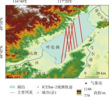
Fig. 1
Overview of the study area and ICESat-2 satellite observation trajectories"

Tab. 1
Basic parameters of the ICESat-2 satellite"
| ICESat-2卫星 | 参数 | ICESat-2卫星 | 参数 |
|---|---|---|---|
| 高度计 | ATLAS | 脉冲宽度 | 1 ns |
| 运行时间 | 2018年至今 | 波长 | 532 nm |
| 轨道高度 | 500 km | 波束数 | 6 束 |
| 重复周期 | 91 d | 光斑间隔 | 0.7 m |
| 轨道倾角 | 92° | 光斑直径 | 17 m |
| 脉冲能量 | 0.2~1.2 mJ | 单次测距标称精度 | 2.3 cm |
| 脉冲重复频率 | 10 kHz | 相邻波束间隔 | 90 m |
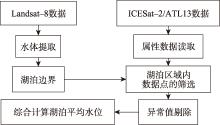
Fig. 2
ICESat-2/ATL13 data processing flow"


Fig. 3
Changes in the daily average water level of Hulun Lake from November 2018-January 2022"

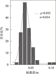
Fig. 4
Histogram of standard deviation per period of ICESat-2 data"
Tab. 2
Comparison of results in the calculation of Lake Hulun water level from different water level product data"
| 产品水位差 | Max/cm | Min/cm | STD/cm | RMS/cm |
|---|---|---|---|---|
| DAHITI-本研究 | 16.7 | -13.7 | 6.8 | 7.0 |
| Hydroweb-本研究 | 24.1 | -26.0 | 10.8 | 10.8 |
| DAHITI-Hydroweb | 21.7 | -26.4 | 9.7 | 9.8 |
| G-REALM-本研究 | 28.1 | -21.0 | 10.6 | 11.2 |
| G-REALM-DAHITI | 27.5 | -23..4 | 10.7 | 11.1 |
| G-REALM-Hydroweb | 16.9 | -10.6 | 5.8 | 6.6 |
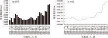
Fig. 5
Lake area (a) and water level (b) change from 2018 to 2021"

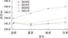
Fig. 6
Seasonal variation characteristics of lake water level"

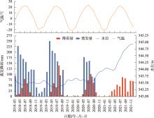
Fig. 7
Statistical analysis of ICESat-2 monitoring water level with air temperature, precipitation and evaporation"

| [1] |
Pekel J F, Cottam A, Gorelick N, et al. High-resolution mapping of global surface water and its long-term changes[J]. Nature, 2016, 540(7633): 418-422.
doi: 10.1038/nature20584 |
| [2] | 赵云, 廖静娟, 沈国状, 等. 卫星测高数据监测青海湖水位变化[J]. 遥感学报, 2017, 21(4): 633-644. |
| [Zhao Yun, Liao Jingjuan, Shen Guozhuang, et al. Monitoring the water level changes in Qinghai Lake with satellite altimetry data[J]. Journal of Remote Sensing, 2017, 21(4): 633-644.] | |
| [3] | 葛莉, 习晓环, 王成, 等. ICESat-1/GLAS数据湖泊水位监测研究进展[J]. 遥感技术与应用, 2017, 32(1): 14-19. |
| [Ge Li, Xi Xiaohuan, Wang Cheng, et al. Research Progress of ICESat-1/GLAS in Lake Level Monitoring[J]. Remote Sensing Technology and Application, 2017, 32(1): 14-19.] | |
| [4] |
Song C, Huang B, Ke L, et al. Seasonal and abrupt changes in the water level of closed lakes on the Tibetan Plateau and implications for climate impacts[J]. Journal of Hydrology, 2014, 514(6): 131-144.
doi: 10.1016/j.jhydrol.2014.04.018 |
| [5] |
Yuan C, Gong P, Liu C, et al. Water-volume variations of Lake Hulun estimated from serial Jason altimeters and Landsat TM/ETM+ images from 2002 to 2017[J]. International Journal of Remote Sensing, 2019, 40(2): 670-692.
doi: 10.1080/01431161.2018.1516316 |
| [6] | 廖静娟, 沈国状, 赵云. 多源雷达高度计全球典型湖泊水位变化数据集(2002—2016)[J]. 全球变化数据学报, 2018, 2(3): 295-302, 184-191. |
| [Liao Jingjuan, Shen Guozhuang, Zhao Yun. Dataset of global lake level changes using multialtimeter data (2002-2016)[J]. Journal of Global Change Data & Discovery, 2018, 2(3): 295-302, 184-191.] | |
| [7] |
Yan T L, Yi C L, Jen Y H. Automatic water-level detection using single-camera images with varied poses[J]. Measurement, 2018, 127(139): 167-174.
doi: 10.1016/j.measurement.2018.05.100 |
| [8] |
Narin O G, Abdikan S. Multi-temporal analysis of inland water level change using ICESat-2 ATL-13 data in lakes and dams[J]. Environmental Science and Pollution Research, 2022, 30(6): 15364-15376.
doi: 10.1007/s11356-022-23172-9 |
| [9] | Guo X, Jin S, Zhang Z.Evaluation of water level estimation in the upper Yangtze River from ICESat-2 data[C]// Hangzhou: Photonics & Electromagnetics Research Symposium (PIERS), 2021, 2260-2264. |
| [10] | Ryan J C, Smith L C, Cooley S W, et al. Global characterization of inland water reservoirs using ICESat-2 altimetry and climate reanalysis[J]. Geophysical Research Letters, 2020, 47(17): e2020GL-088543. |
| [11] | 马山木, 甘甫平, 吴怀春, 等.ICESat-2数据监测青藏高原湖泊2018—2021年水位变化[J]. 自然资源遥感, 2022, 34(3): 164-172. |
| [Ma Shanmu, Gan Fuping, Wu Huaichun, et al. ICESat-2 data-based monitoring of 2018-2021 variations in the water levels of lakes in the Qinghai-Tibet Plateau[J]. Remote Sensing of Natural Resources, 2022, 34(3): 164-172.] | |
| [12] | 吴红波, 王宁练, 郭忠明. ICESat-2/ATLAS测高数据在青海湖湖泊水位估计中的应用[J]. 水资源与水工程学报, 2021, 32(5): 11-18, 26. |
| [Wu Hongbo, Wang Ninglian, Guo Zhongming. Application of ICESat-2/ATLAS altimetry data to the estimation of the Qinghai Lake level[J]. Journal of Water Resources and Water Engineering, 2021, 32(5): 11-18, 26.] | |
| [13] | 孙伟, 金建文, 李国元, 等. 激光测高卫星ICESat-2监测太湖水位精度评价[J]. 测绘科学, 2021, 46(11): 6-11. |
| [Sun Wei, Jin Jianwen, Li Guoyuan, et al. Accuracy evaluation of laser altimetry satellite ICESat-2 in monitoring water level of Taihu Lake[J]. Geomatics Science, 2021, 46(11): 6-11.] | |
| [14] |
Liu C, Hu R, Wang Y, et al. Monitoring water level and volume changes of lakes and reservoirs in the Yellow River Basin using ICESat-2 laser altimetry and Google Earth Engine[J]. Journal of Hydro-environment Research, 2022, 44(12): 53-64.
doi: 10.1016/j.jher.2022.07.005 |
| [15] |
Xu N, Ma Y, Zhang W H, et al. Monitoring annual changes of lake water levels and volumes over 1984-2018 using landsat imagery and ICESat-2 data[J]. Remote Sensing, 2020, 12(23): 4004.
doi: 10.3390/rs12234004 |
| [16] | 郭孝祖, 金双根. 利用ICESat-2激光测高监测长江三峡水位变化[J]. 测绘科学, 2022, 47(7): 21-26. |
| [Guo Xiaozu, Jin Shuanggen. Water level changes in the Three Gorges of the Yangtze River from ICESat-2 laser altimetry[J]. Geomatics Science, 2022, 47(7): 21-26.] | |
| [17] | 李国元. 对地观测卫星激光测高数据处理方法与工程实践[D]. 武汉: 武汉大学, 2017. |
| [Li Guoyuan. Earth Observation Satellite Laser Altimetry Data Processing Methods and Engineering Practices[D]. Wuhan: Wuhan University, 2017.] | |
| [18] |
Crétaux J F, Calmant S, Romanovski V, et al. An absolute calibration site for radar altimeters in the continental do-main: Lake Issykkul in Central Asia[J]. Journal of Geodesy, 2019, 83(8): 723-735.
doi: 10.1007/s00190-008-0289-7 |
| [19] |
Schwatke C, Dettmering D, Bosch W et al. DAHITI-an innovative approach for estimating water level time series over inland waters using multi-mission satellite altimetry[J]. Hydrology and Earth System Sciences, 2015, 19(10): 4345-4364.
doi: 10.5194/hess-19-4345-2015 |
| [20] |
Leys C, Ley C, Klein O, et al. Detecting outliers: Do not use standard deviation around the mean, use absolute deviation around the median[J]. Journal of Experimental Social Psychology, 2013, 49(4): 764-766.
doi: 10.1016/j.jesp.2013.03.013 |
| [21] | 孙明智, 刘新, 汪海洪, 等. 多源卫星测高数据监测拉昂错1992—2020年水位变化[J]. 遥感学报, 2022, 26(1): 126-137. |
| [Sun Mingzhi, Liu Xin, Wang Haihong, et al. Monitoring water level changes in La-ang Co from 1992-2020 using multi-source data[J]. Journal of Remote Sensing, 2022, 26(1): 126-137.] | |
| [22] | 王文种, 黄对, 刘九夫, 等.基于Landsat与Sentinel-3A卫星数据的当惹雍错1988—2018年湖泊水位—水量变化及归因[J]. 湖泊科学, 2020, 32(5): 1552-1563. |
| [Wang Wenzhong, Huang Dui, Liu Jiufu, et al. Patterns and causes of changes in water level and volume in Tangra Yumco from 1988 to 2018 based on Landsat images and Sentinel-3A synthetic aperture radar[J]. Lake Sciences, 2020, 32(5): 1552-1563.] |
|
||