Arid Zone Research ›› 2022, Vol. 39 ›› Issue (1): 282-291.doi: 10.13866/j.azr.2022.01.27
Previous Articles Next Articles
WANG Yufang( ),ZHAO Chengzhang(),ZENG Hongxia,KANG Manping,ZHAO Tingting,TANG Yurui
Received:2021-01-18
Revised:2021-03-15
Online:2022-01-15
Published:2022-01-24
Contact:
Chengzhang ZHAO
E-mail:1481977435@qq.com;zhaocz601@163.com
WANG Yufang,ZHAO Chengzhang,ZENG Hongxia,KANG Manping,ZHAO Tingting,TANG Yurui. Spatial-temporal evolution of wetland landscape patterns and its influencing factors in the middle reaches of the Shule River[J].Arid Zone Research, 2022, 39(1): 282-291.
Add to citation manager EndNote|Reference Manager|ProCite|BibTeX|RefWorks
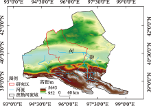
Fig. 1
Schematic diagram of study area location"

Tab. 1
Landscape types and interpretation marks in alpine wetland of middle reaches of the Shule River"
| 湿地类 | 湿地型 | 景观特征 | 遥感影像特征 | 543波段 组合显示 | 野外实地图片 |
|---|---|---|---|---|---|
| 河流湿地 | 永久性河流湿地 | 有明显水面、河道以及水流痕迹 | 呈条带状分布,边界清晰,呈绿色、浅绿色,影纹均匀 | 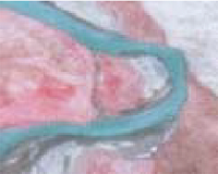 | 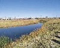 |
| 人工湿地 | 库塘湿地 | 水面规则明显,不杂乱,无其他景观交叉 | 形状规则,纹理均一,呈深蓝色 | 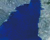 | 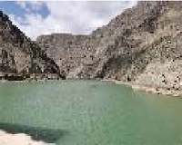 |
| 沼泽湿地 | 草本沼泽 | 分布于水体边缘,团状、块状簇拥集中,参杂裸露水面 | 形状不规则,呈黑红色或深红色,影纹不均、粗糙 | 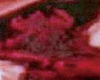 | 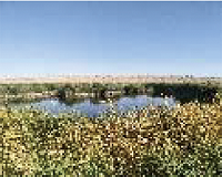 |
| 沼泽化草甸 | 分布于草本沼泽边缘,地势平坦、低洼处,景观较为均质,植被以苔草、嵩草为主 | 片状分布,边界不规则,呈浅红色,纹理比较均匀 |  | 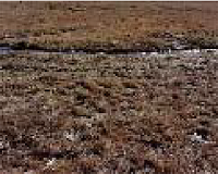 | |
| 内陆盐沼 | 集中连片,生长着芨芨草、赖草、芦苇,因植被盖度和类型不一,景观有明显的穿插现象 | 片状分布,有交叉纹路,呈淡红色或浅灰色 | 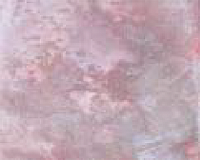 |  | |
| 主要以泌盐植物柽柳为优势种,地表长有高度较低的芦苇和赖草,面积较大 | 有点状、团簇状的红色斑点,质地粗糙 | 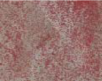 | 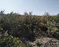 |
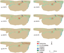
Fig. 2
Wetland types in the middle reaches of Shule River from 1987 to 2017"


Fig. 3
Map of area changes of wetlands"
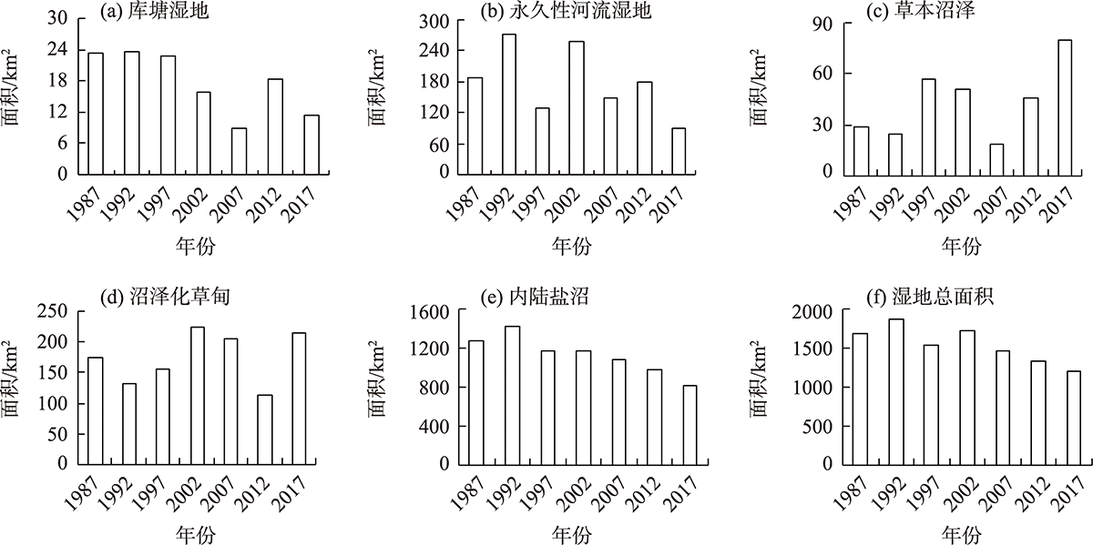
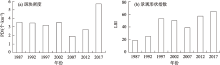
Fig. 4
Inter-annual changes of PD and LSI in landscape-level"

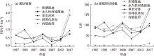
Fig. 5
Inter-annual changes of PD and LSI in class-level"

Tab. 2
Main social and economic indicators of Guazhou County"
| 年份 | 总人口/108 人 | 地区生产总值/108 元 | 耕地面积/104 hm2 | 第一产业值/108 元 |
|---|---|---|---|---|
| 1987 | 6.8 | 0.67 | 1.45 | 0.35 |
| 1992 | 7.6 | 1.47 | 1.53 | 0.64 |
| 1997 | 9.07 | 5.22 | 1.58 | 2.05 |
| 2002 | 9.79 | 7.86 | 1.61 | 3.13 |
| 2007 | 11.71 | 17.52 | 2.40 | 5.01 |
| 2012 | 14.72 | 60.64 | 3.71 | 8.24 |
| 2017 | 14.96 | 72.41 | 3.68 | 11.89 |
Tab. 3
Principal component factor load matrix of climate, human factors and wetland type change"
| 指标 | 主成分1 | 主成分2 |
|---|---|---|
| 年均温/℃ | 0.23 | 0.93 |
| 年降水量/mm | 0.67 | -0.58 |
| 总人口/人 | 0.97 | 0.01 |
| 地区生产总值/元 | 0.97 | 0.04 |
| 耕地面积/hm2 | 0.89 | 0.29 |
| 第一产业值/元 | 0.96 | 0.17 |
| 方差贡献率/% | 68.89 | 22.09 |
| [1] |
Zhao Wenzhi, Liu Bing, Zhang Zhihui. Water requirements of maize in the middle Heihe River Basin, China[J]. Agricultural Water Management, 2009, 97(2): 215-223.
doi: 10.1016/j.agwat.2009.09.011 |
| [2] | 徐晓龙, 王新军, 朱新萍, 等. 1996—2015年巴音布鲁克天鹅湖高寒湿地景观格局演变分析[J]. 自然资源学报, 2018, 33(11): 1897-1911. |
| [Xu Xiaolong, Wang Xinjun, Zhu Xinping, et al. Landscape pattern changes in alpine wetland of Bayanbulak Swan Lake during 1996-2015[J]. Journal of Natural Resources, 2018, 33(11): 1897-1911. ] | |
| [3] |
Cui Lu, Zhao Yonghua, Liu Jianchao, et al. Landscape ecological risk assessment in Qinling Mountain[J]. Geological Journal, 2018, 53: 342-351.
doi: 10.1002/gj.v53.S1 |
| [4] |
Gong Peng, Niu Zhengguo, Cheng Xiao, et al. China’s wetland change (1990-2000) determined by remote sensing[J]. Science China (Earth Sciences), 2010, 53(7): 1036-1042.
doi: 10.1007/s11430-010-4002-3 |
| [5] | 黄犁, 徐丽萍. 玛纳斯河流域绿洲时空演变及其景观格局变化[J]. 干旱区研究, 2019, 36(5): 1261-1269. |
| [Huang Li, Xu Liping. Spatiotemporal evolution of the oasis and change of landscape pattern in the Manas River Basin[J]. Arid Zone Research, 2019, 36(5): 1261-1269. ] | |
| [6] | 吴金华, 房世峰, 刘宝军, 等. 乌裕尔河—双阳河流域湿地景观格局演变及其驱动机制[J]. 生态学报, 2020, 40(13): 4279-4290. |
| [Wu Jinhua, Fang Shifeng, Liu Baojun, et al. Landscape pattern evolution of wetland and its driving mechanism in Wuyuer-Shuangyang River Basin[J]. Acta Ecologica Sinica, 2020, 40(13): 4279-4290. ] | |
| [7] | 孙鸿超, 张正祥. 吉林省松花江流域景观格局脆弱性变化及其驱动力[J]. 干旱区研究, 2019, 36(4): 1005-1014. |
| [Sun Hongchao, Zhang Zhengxiang. Change of landscape pattern vulnerability in the Songhua River Basin in Jilin Province and its driving forces[J]. Arid Zone Research, 2019, 36(4): 1005-1014. ] | |
| [8] | 王晓峰, 延雨, 李月皓, 等. 银川市湿地景观演变及其驱动因素[J]. 干旱区研究, 2021, 38(3): 855-866. |
| [Wang Xiaofeng, Yan Yu, Li Yuehao, et al. Wetland landscape evolution and its driving factors in Yinchuan[J]. Arid Zone Research, 2021, 38(3): 855-866. ] | |
| [9] |
Chen Ang, Sui Xin, Wang Dongsheng, et al. Landscape and avifauna changes as an indicator of Yellow River Delta Wetland restoration[J]. Ecological Engineering, 2016, 86: 162-173.
doi: 10.1016/j.ecoleng.2015.11.017 |
| [10] | 王效科, 欧阳志云, 苗鸿. 中国西北干旱地区湿地生态系统的形成、演变和保护对策[J]. 国土与自然资源研究, 2003, 25(4): 52-54. |
| [Wang Xiaoke, Ouyang Zhiyun, Miao Hong. Formation, evalution and protection of wetland ecosystems in arid region, Northwestern China[J]. Territory and Natural Resources Study, 2003, 25(4): 52-54. ] | |
| [11] | 姚鑫, 杨桂山, 万荣荣, 等. 水位变化对河流、湖泊湿地植被的影响[J]. 湖泊科学, 2014, 26(6): 813-821. |
| [Yao Xin, Yang Guishan, Wan Rongrong, et al. Impact of water level change on wetland vegetation of rivers and lakes[J]. Journal of Lake Sciences, 2014, 26(6): 813-821. ] | |
| [12] | 章光新, 武瑶, 吴燕锋, 等. 湿地生态水文学研究综述[J]. 水科学进展, 2018, 29(5): 737-749. |
| [Zhang Guangxin, Wu Yao, Wu Yanfeng, et al. A review of research on wetland ecohydrology[J]. Advances in Water Science, 2018, 29(5): 737-749. ] | |
| [13] |
Liu Guilin, Zhang Luocheng, Zhang Qian, et al. Spatio-temporal dynamics of wetland landscape patterns based on remote sensing in Yellow River Delta, China[J]. Wetlands, 2014, 34(4): 787-801.
doi: 10.1007/s13157-014-0542-1 |
| [14] |
Zhang Yujuan, Qu Jianguang, Li Dan. Evolution and prediction of coastal wetland landscape pattern: An exploratory study[J]. Journal of Coastal Research, 2020, 106(Suppl.): 553-556.
doi: 10.2112/SI106-125.1 |
| [15] | 王根绪, 李元寿, 王一博, 等. 近40 a来青藏高原典型高寒湿地系统的动态变化[J]. 地理科学, 2007, 62(5): 481-491. |
| [Wang Genxu, Li Yuanshou, Wang Yibo, et al. Typical alpine wetland system changes on the Qinghai-Tibet Plateau in recent 40 years[J]. Acta Geographica Sinica, 2007, 62(5): 481-491. ] | |
| [16] | 赵锐锋, 姜朋辉, 赵海莉, 等. 黑河中游湿地景观破碎化过程及其驱动力分析[J]. 生态学报, 2013, 33(14): 4436-4449. |
| [Zhao Ruifeng, Jiang Penghui, Zhao Haili, et al. Fragmentation process of wetlands landscape in the middle reaches of the Heihe River and its driving forces analysis[J]. Acta Ecologica Sinica, 2013, 33(14): 4436-4449. ] | |
| [17] | 曾光, 高会军, 朱刚. 塔里木河三源流区湿地演化特征遥感分析[J]. 干旱区资源与环境, 2014, 28(3): 68-73. |
| [Zeng Guang, Gao Huijun, Zhu Gang. Wetland evolution process of the three headwaters in the upper reaches of the Tarim River watershed based on RS[J]. Journal of Arid Land Resources and Environment, 2014, 28(3): 68-73. ] | |
| [18] | 周亚军, 刘廷玺, 段利民, 等. 锡林河流域上游河谷湿地景观格局演变及其驱动力[J]. 干旱区研究, 2020, 37(3): 580-590. |
| [Zhou Yajun, Liu Tingxi, Duan Limin, et al. Driving force analysis and landscape pattern evolution in the upstream valley of Xilin River Basin[J]. Arid Zone Research, 2020, 37(3): 580-590. ] | |
| [19] | 岳东霞, 陈冠光, 朱敏翔, 等. 近20 a疏勒河流域生态承载力和生态需水研究[J]. 生态学报, 2019, 39(14): 5178-5187. |
| [Yue Dongxia, Chen Guanguang, Zhu Minxiang, et al. Biocapacity and ecological water demand in Shule River Basin over the past 20 Years[J]. Acta Ecologica Sinica, 2019, 39(14): 5178-5187. ] | |
| [20] | 岳东霞, 苗俊霞, 朱敏翔, 等. 疏勒河流域陆地水储量与植被指数的时空耦合关系[J]. 生态学报, 2019, 39(14): 5268-5278. |
| [Yue Dongxia, Miao Junxia, Zhu Minxiang, et al. Spatio-temporal coupling between terrestrial water storage and Vegetation Index in Shule River Basin[J]. Acta Ecologica Sinica, 2019, 39(14): 5268-5278. ] | |
| [21] | 潘竟虎, 刘晓. 疏勒河流域景观生态风险评价与生态安全格局优化构建[J]. 生态学杂志, 2016, 35(3): 791-799. |
| [Pan Jinghu, Liu Xiao. Landscape ecological risk assessment and landscape security pattern optimization in Shule River Basin[J]. Chinese Journal of Ecology, 2016, 35(3): 791-799. ] | |
| [22] | Da Fuwen, Chen Xingpeng, Qi Jinghui. Spatiotemporal characteristic of land use/land cover changes in the middle and lower reaches of Shule River Basin based on an intensity analysis[J]. Sustainbility, 2019, 11(5): 1-19. |
| [23] | 章予舒, 王立新, 张红旗, 等. 疏勒河流域土地利用变化驱动因素分析——以安西县为例[J]. 地理科学进展, 2003, 22(3): 170-178. |
| [Zhang Yushu, Wang Lixin, Zhang Hongqi, et al. An analysis on land use changes and their driving factors in Shule River: An example from Anxi County[J]. Progress in Geography, 2003, 22(3): 170-178. ] | |
| [24] | 杜际增, 王根绪, 杨燕, 等. 长江黄河源区湿地分布的时空变化及成因[J]. 生态学报, 2015, 35(18): 6173-6182. |
| [Du Jizeng, Wang Genxu, Yang Yan, et al. Temporal and spatial variation of the distributive patterns and driving force analysis in the Yangtze River and Yellow River source regions wetland[J]. Acta Ecologica Sinica, 2015, 35(18): 6173-6182. ] | |
| [25] | 常跟应, 张文侠. 基于生态文明的疏勒河流域大规模移民反思[J]. 兰州大学学报(自然科学版), 2014, 50(3): 405-409. |
| [Chang Genying, Zhang Wenxia. Ecological civilization-based rethinking of large-scale immigration and land development along Shule River[J]. Journal of Landzhou University (Natural Sciences), 2014, 50(3): 405-409. ] | |
| [26] | 章光新, 武瑶, 吴燕锋, 等. 湿地生态水文学研究综述[J]. 水科学进展, 2018, 29(5): 737-749. |
| [Zhang Guangxin, Wu Yao, Wu Yanfeng, et al. A review of research on wetland ecohydrology[J]. Advances in Water Science, 2018, 29(5): 737-749. ] | |
| [27] | 李山羊, 郭华明, 黄诗峰, 等. 1973—2014年河套平原湿地变化研究[J]. 资源科学, 2016, 38(1): 19-29. |
| [Li Shanyang, Guo Huaming, Huang Shifeng, et al. Variation in Hetao Basin wetlands from 1973 to 2014[J]. Resources Science, 2016, 38(1): 19-29. ] | |
| [28] | 刘彩红, 王翀, 曾平, 等. 丹江口水库水源地生态节地型人工湿地设计——以内乡县温家堰河内源治理与湿地修复工程为例[J]. 农业开发与装备, 2020, 25(3): 77-78. |
| [Liu Caihong, Wang Chong, Zeng Ping, et al. Design of ecological land saving constructed wetland in Danjiangkou Reservoir: Taking wenjiayan river source control and wetland restoration project in Neixiang County as an example[J]. Agricultural Development Equipments, 2020, 25(3): 77-78. ] | |
| [29] | 吕金霞, 蒋卫国, 王文杰, 等. 近30 a来京津冀地区湿地景观变化及其驱动因素[J]. 生态学报, 2018, 38(12): 4492-4503. |
| [Lyu Jinxia, Jiang Weiguo, Wang Wenjie, et al. Wetland landscape pattern change and its driving forces in Beijing-Tianjin-Hebei region in recent 30 years[J]. Acta Ecologica Sinica, 2018, 38(12): 4492-4503. ] | |
| [30] | 张敏, 宫兆宁, 赵文吉, 等. 近30 a来白洋淀湿地景观格局变化及其驱动机制[J]. 生态学报, 2016, 36(15): 4780-4791. |
| [Zhang Min, Gong Zhaoning, Zhao Wenji, et al. Landscape pattern change and the driving forces in Baiyangdian wetland from 1984 to 2014[J]. Acta Ecologica Sinica, 2016, 36(15): 4780-4791. ] | |
| [31] | 赵锐锋, 姜朋辉, 赵海莉, 等. 土地利用/覆被变化对张掖黑河湿地国家级自然保护区景观破碎化的影响[J]. 自然资源学报, 2013, 28(4): 583-595. |
| [Zhao Ruifeng, Jiang Penghui, Zhao Haili, et al. Effect of land use/cover change on landscape fragmentation of Zhangye Heihe National Wetland Nature Reserve[J]. Journal of Natural Resources, 2013, 28(4): 583-595. ] | |
| [32] |
Yu Haiyang, Zhang Fei, Kung Hsiang Te, et al. Analysis of land cover and landscape change patterns in Ebinur Lake Wetland National Nature Reserve, China from 1972 to 2013[J]. Wetlands Ecology and Management, 2017, 25(5): 619-637.
doi: 10.1007/s11273-017-9541-3 |
| [33] | 刘吉平, 李艾玉, 田学智, 等. 三江平原孤立湿地的形成及主要类型[J]. 湿地科学, 2014, 12(2): 141-147. |
| [Liu Jiping, Li Aiyu, Tian Xuezhi, et al. Formation and main types of isolated wetlands in Sanjiang Plain[J]. Wetland Science, 2014, 12(2): 141-147. ] | |
| [34] |
张金茜, 巩杰, 柳冬青. 地理探测器方法下甘肃白龙江流域景观破碎化与驱动因子分析[J]. 地理科学, 2018, 38(8): 1370-1378.
doi: 10.13249/j.cnki.sgs.2018.08.020 |
|
[Zhang Jinxi, Gong Jie, Liu Dongqing. Dynamics and driving factors of landscape fragmentation based on Geo Detector in the Bailongjiang Watershed of Gansu Province[J]. Scientia Geographica Sinica, 2018, 38(8): 1370-1378. ]
doi: 10.13249/j.cnki.sgs.2018.08.020 |
|
||