Arid Zone Research ›› 2022, Vol. 39 ›› Issue (1): 292-300.doi: 10.13866/j.azr.2022.01.28
Previous Articles Next Articles
LIU Chang1( ),ZHANG Hong2,3(),ZHANG Xiaoyu2,3,YANG Guoting2,LIU Yong1,3
Received:2021-04-14
Revised:2021-06-23
Online:2022-01-15
Published:2022-01-24
Contact:
Hong ZHANG
E-mail:912555609@qq.com;zhanghong@sxu.edu.cn
LIU Chang,ZHANG Hong,ZHANG Xiaoyu,YANG Guoting,LIU Yong. Spatio-temporal evolution and prediction of land use in semi-arid mining areas[J].Arid Zone Research, 2022, 39(1): 292-300.
Add to citation manager EndNote|Reference Manager|ProCite|BibTeX|RefWorks

Fig. 1
Diagram of the study area"

Tab. 1
Data source"
| 数据类型 | 数据名称 | 数据来源 |
|---|---|---|
| 自然因子 | 高程 | 中国科学院资源环境科学数据中心( |
| 坡度、坡向 | 基于高程(DEM)数据提取 | |
| 气温、降水 | 中国气象数据网( | |
| 社会经济因子 | 煤矿生产能力 | 采用实际调查获取 |
| 人口 | 中国科学院资源环境科学数据中心( | |
| 距离因子 | 距公路、铁路、水系距离 | 采用ArcGIS 10.5中欧氏距离算法计算 |
| 距设施点、居民点距离 | POI数据采用网络爬虫技术获取服务设施 | |
| 土地利用数据 | 1985年、1995年、2005年、2015年遥感影像 | 中国科学院资源环境科学数据中心( |
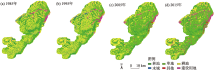
Fig. 2
Spatial distribution of land use in Datong coal mining area from 1985 to 2015"


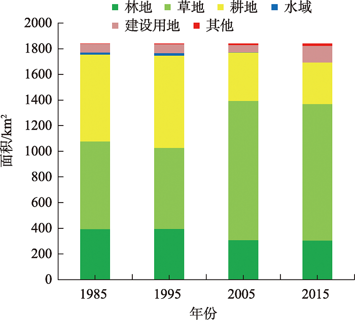
Fig. 3
Changes of land type area in Datong coal mining area in each year"
Tab. 2
Land use transfer probability matrix in Datong coal mining area from 1985 to 2015 /%"
| 年份 | 土地利用类型 | 林地 | 草地 | 耕地 | 水域 | 建设用地 | 其他 |
|---|---|---|---|---|---|---|---|
| 1985—1995 | 林地 | 86.88 | 3.69 | 8.54 | 0.45 | 0.44 | - |
| 草地 | 5.26 | 77.63 | 16.49 | 0.31 | 0.20 | 0.11 | |
| 耕地 | 14.87 | 8.82 | 73.60 | 0.58 | 1.94 | 0.19 | |
| 水域 | 17.31 | 23.64 | 5.41 | 52.47 | 1.17 | - | |
| 建设用地 | 6.72 | 3.18 | 6.27 | 4.02 | 77.55 | 2.25 | |
| 其他 | 26.68 | 1.64 | - | - | 2.35 | 69.33 | |
| 1995—2005 | 林地 | 10.44 | 55.93 | 31.2 | 0.10 | 2.07 | 0.27 |
| 草地 | 35.7 | 49.14 | 13.26 | 0.14 | 1.07 | 0.68 | |
| 耕地 | 13.36 | 72.58 | 11.59 | 0.12 | 1.75 | 0.60 | |
| 水域 | 21.23 | 31.28 | 33.39 | 0.33 | 13.47 | 0.30 | |
| 建设用地 | 4.17 | 32.89 | 27.64 | 0.05 | 32.92 | 2.33 | |
| 其他 | 7.02 | 47.12 | 7.08 | 0.37 | 28.75 | 9.66 | |
| 2005—2015 | 林地 | 99.20 | - | 0.06 | - | 0.30 | 0.44 |
| 草地 | - | 97.54 | 0.05 | - | 2.24 | 0.18 | |
| 耕地 | - | 1.03 | 85.99 | - | 12.97 | 0.01 | |
| 水域 | - | 2.12 | 3.52 | - | 94.35 | ||
| 建设用地 | - | - | - | - | 100.00 | - | |
| 其他 | - | - | - | - | - | 100.00 |
Fig. 4
The importance of different types of influencing factors in Datong coal mining area in 2015"
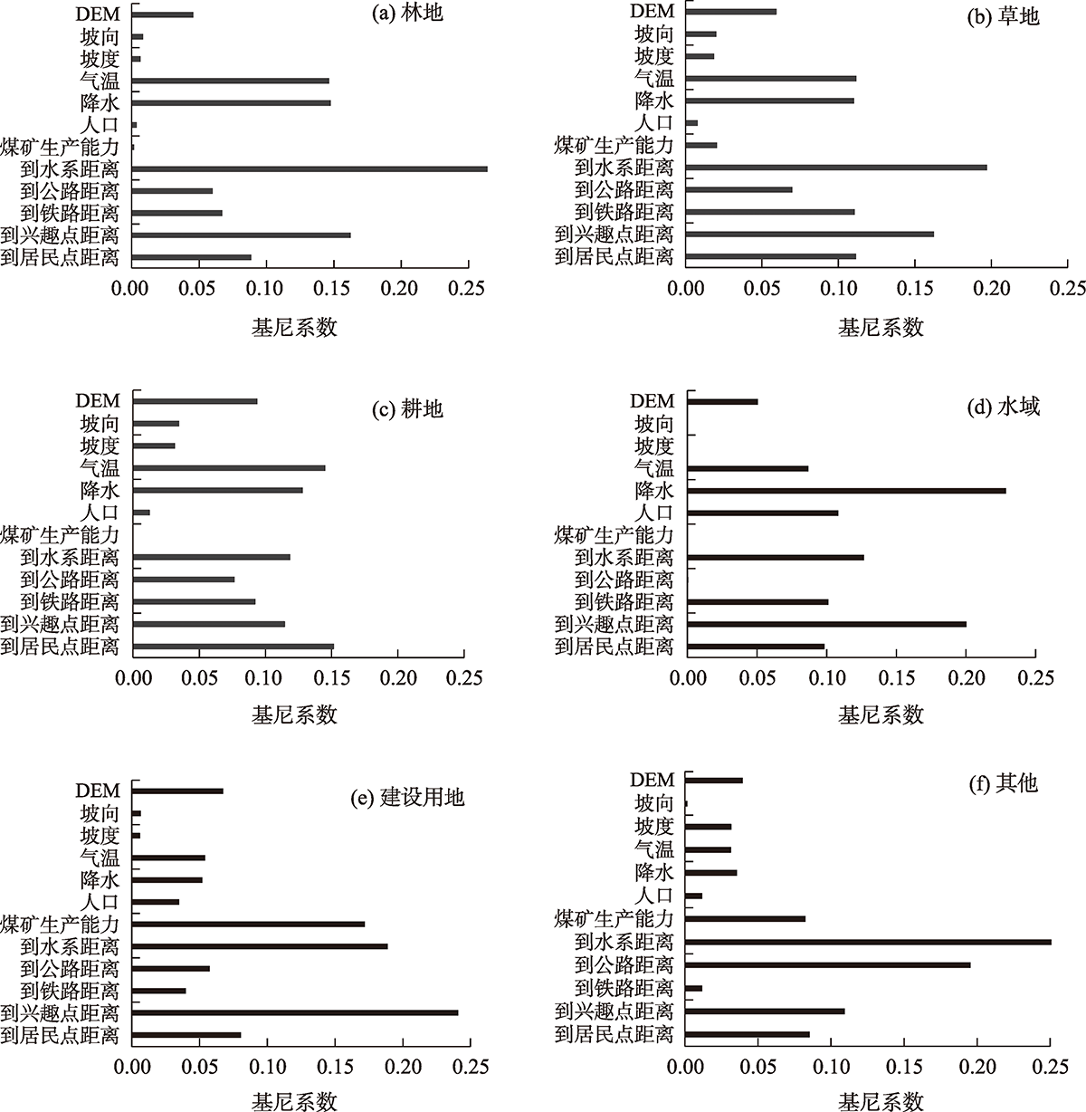

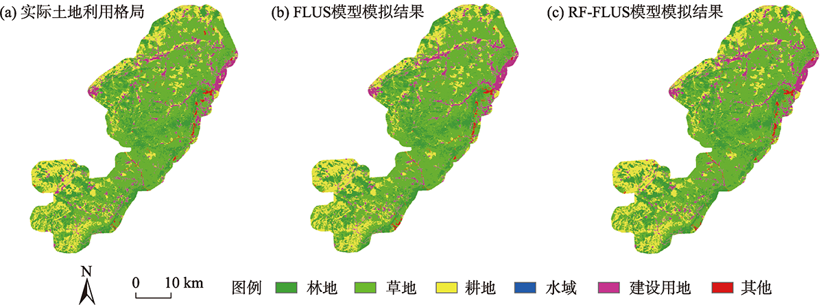
Fig. 5
Land use pattern and model simulation results in Datong coal mining area in 2015"
Tab. 3
Confusion matrix of RF-FLUS model and FLUS model /%"
| RF-FLUS模型 | FLUS模型 | ||||||||||||
|---|---|---|---|---|---|---|---|---|---|---|---|---|---|
| 林地 | 草地 | 耕地 | 水域 | 建设用地 | 其他 | 林地 | 草地 | 耕地 | 水域 | 建设用地 | 其他 | ||
| 林地 | 95.03 | 1.73 | 1.35 | 0.00 | 0.00 | 0.20 | 林地 | 93.25 | 2.14 | 1.80 | 0.00 | 0.00 | 0.33 |
| 草地 | 2.35 | 95.71 | 2.60 | 0.00 | 0.00 | 5.71 | 草地 | 2.94 | 95.33 | 2.32 | 10.00 | 0.00 | 6.03 |
| 耕地 | 2.02 | 1.20 | 94.57 | 0.00 | 0.00 | 0.26 | 耕地 | 2.54 | 1.62 | 93.52 | 0.00 | 0.00 | 0.26 |
| 水域 | 0.00 | 0.00 | 0.00 | 100.00 | 0.00 | 0.00 | 水域 | 0.00 | 0.00 | 0.00 | 90.00 | 0.00 | 0.00 |
| 建设用地 | 0.28 | 1.17 | 1.40 | 0.00 | 100.00 | 0.13 | 建设用地 | 0.66 | 0.85 | 2.05 | 0.00 | 100.00 | 0.20 |
| 其他 | 0.32 | 0.19 | 0.08 | 0.00 | 0.00 | 93.70 | 其他 | 0.61 | 0.06 | 0.31 | 0.00 | 0.00 | 93.18 |
| 总计 | 100.00 | 100.00 | 100.00 | 100.00 | 100.00 | 100.00 | 总计 | 100.00 | 100.00 | 100.00 | 100.00 | 100.00 | 100.00 |
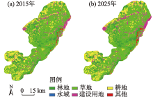
Fig. 6
Distribution pattern of land use in Datong coal mining area in 2015 and 2025"

| [1] | 李胜鹏, 柳建玲, 林津, 等. 基于1980—2018年土地利用变化的福建省生境质量时空演变[J]. 应用生态学报, 2020, 31(12): 4080-4090. |
| [Li Shengpeng, Liu Jianling, Lin Jin, et al. Spatial and temporal evolution of habitat quality in Fujian Province, China based on the land use change from 1980 to 2018[J]. Chinese Journal of Applied Ecology, 2020, 31(12): 4080-4090. ] | |
| [2] | 刘纪远, 张增祥, 庄大方, 等. 20世纪90年代中国土地利用变化时空特征及其成因分析[J]. 地理研究, 2003, 22(1): 1-12. |
| [Liu Jiyuan, Zhang Zengxiang, Zhuang Dafang, et al. A study on the spatial-temporal dynamic changes of land-use and driving forces analyses of China in the 1990s[J]. Geographical Research, 2003, 22(1): 1-12. ] | |
| [3] |
Veldkamp A, Lambin E F. Predicting land-use change[J]. Agriculture, Ecosystems and Environment, 2001, 85(1): 1-6.
doi: 10.1016/S0167-8809(01)00199-2 |
| [4] | 李保杰, 顾和和, 纪亚洲. 基于CLUE-S模型的矿区土地利用变化情景模拟——以徐州市贾汪矿区为例[J]. 热带地理, 2018, 38(2): 274-281. |
| [Li Baojie, Gu Hehe, Ji Yazhou. Simulation of land use change in coal mining area under different scenarios based on the CLUE-S model: A case study of jiawang mining area in Xuzhou city[J]. Tropical Geography, 2018, 38(2): 274-281. ] | |
| [5] | 刘彦文, 刘成武, 何宗宜, 等. 基于地理加权回归模型的武汉城市圈生态用地时空演变及影响因素[J]. 应用生态学报, 2020, 31(3): 987-998. |
| [Liu Yanwen, Liu Chengwu, He Zongyi, et al. Spatial-temporal evolution of ecological land and influence factors in Wuhan urban agglomeration based on geographically weighted regression model[J]. Chinese Journal of Applied Ecology, 2020, 31(3): 987-998. ] | |
| [6] |
孙毅中, 杨静, 宋书颖, 等. 多层次矢量元胞自动机建模及土地利用变化模拟[J]. 地理学报, 2020, 75(10): 2164-2179.
doi: 10.11821/dlxb202010009 |
|
[Sun Yizhong, Yang Jing, Song Shuying, et al. Modeling of multilevel vector cellular automata and its simulation of land use change[J]. Acta Geographica Sinica, 2020, 75(10): 2164-2179. ]
doi: 10.11821/dlxb202010009 |
|
| [7] | 徐红涛, 陈春波, 郑宏伟, 等. 基于相关分析和自适应遗传算法的盐渍化建模变量和参数优选[J]. 地球信息科学学报, 2020, 22(7): 1497-1509. |
| [Xu Hongtao, Chen Chunbo, Zheng Hongwei, et al. Correlation analysis and adaptive genetic algorithm based feature subset and model parameter optimization in salinization monitoring[J]. Journal of Geo-information Science, 2020, 22(7): 1497-1509. ] | |
| [8] | 王梓洋, 石培基, 张学斌, 等. 基于多智能体模型的兰州市城镇用地扩展模拟[[J]. 应用生态学报, 2021, 32(6): 2169-2179. |
| [Wang Ziyang, Shi Peiji, Zhang Xuebin, et al. Simulation of Lanzhou urban land expansion based on multi-agent model[J]. Chinese Journal of Applied Ecology, 2021, 32(6): 2169-2179. ] | |
| [9] |
戴尔阜, 马良. 土地变化模型方法综述[J]. 地理科学进展, 2018, 37(1): 152-162.
doi: 10.18306/dlkxjz.2018.01.016 |
|
[Dai Erfu, Ma Liang. Review on land change modeling approaches[J]. Progress in Geography, 2018, 37(1): 152-162. ]
doi: 10.18306/dlkxjz.2018.01.016 |
|
| [10] | 周成虎, 欧阳, 马廷, 等. 地理系统模拟的CA模型理论探讨[J]. 地理科学进展, 2009, 28(6): 833-838. |
| [Zhou Chenghu, Ou Yang, Ma Ting, et al. Theoretical perspectives of CA-based geographical system modeling[J]. Progress in Geography, 2009, 28(6): 833-838. ] | |
| [11] | 黎夏, 刘小平. 基于案例推理的元胞自动机及大区域城市演变模拟[J]. 地理学报, 2007, 75(10): 1097-1109. |
| [Li Xia, Liu Xiaoping. Case-based cellular automaton for simulating urban development in a large complex region[J]. Acta Geographica Sinica, 2007, 75(10): 1097-1109. ] | |
| [12] |
Wu F L. Calibration of stochastic cellular automata: The application to rural-urban land conversions[J]. International Journal of Geographical Information Science, 2002, 16(8): 795-818.
doi: 10.1080/13658810210157769 |
| [13] | 杨青生, 黎夏. 基于遗传算法自动获取CA模型的参数——以东莞市城市发展模拟为例[J]. 地理研究, 2007, 26(2): 229-237. |
| [Yang Qingsheng, Li Xia. Calibrating urban cellular automata using genetic algorithms[J]. Geographical Research, 2007, 26(2): 229-237. ] | |
| [14] | 张大川, 刘小平, 姚尧, 等. 基于随机森林CA的东莞市多类土地利用变化模拟[J]. 地理与地理信息科学, 2016, 32(5): 29-36. |
| [Zhang Dachuan, Liu Xiaoping, Yao Yao, et al. Simulating spatiotemporal change of multiple land use types in Dongguan by using random forest based on cellular automata[J]. Geography and Geo-Information Science, 2016, 32(5): 29-36. ] | |
| [15] |
马慧娟, 高小红, 谷晓天. 随机森林方法支持的复杂地形区土地利用/土地覆被分类研究[J]. 地球信息科学学报, 2019, 21(3): 359-371.
doi: 10.12082/dpxxkx.2019.180346 |
|
[Ma Huijuan, Gao Xiaohong, Gu Xiaotian. Random forest classification of Landsat 8 imagery for the complex terrain area based on the combination of spectral, topographic and texture information[J]. Journal of GeoInformation Science, 2019, 21(3): 359-371. ]
doi: 10.12082/dpxxkx.2019.180346 |
|
| [16] |
陈凯, 刘凯, 柳林, 等. 基于随机森林的元胞自动机城市扩展模拟——以佛山市为例[J]. 地理科学进展, 2015, 34(8): 937-946.
doi: 10.18306/dlkxjz.2015.08.001 |
|
[Chen Kai, Liu Kai, Liu Lin, et al. Urban expansion simulation by random-forest-based cellular automata: A case study of Foshan City[J]. Progress in Geography, 2015, 34(8): 937-946. ]
doi: 10.18306/dlkxjz.2015.08.001 |
|
| [17] | 卞正富, 张燕平. 徐州煤矿区土地利用格局演变分析[J]. 地理学报, 2006, 61(4): 349-358. |
| [Bian Zhengfu, Zhang Yanping. Land use changes in Xuzhou coal mining area[J]. Acta Geographica Sinica, 2006, 61(4): 349-358. ] | |
| [18] | 段语凤, 张玉秀, 余创. 煤炭井工开采对干旱荒漠区植被动态变化的影响[J]. 生态学报, 2020, 40(23): 8717-8728. |
| [Duan Yufeng, Zhang Yuxiu, Yu Chuang. Effects of the underground coal mining on the dynamic changes of vegetation in arid desert area[J]. Acta Ecologica Sinica, 2020, 40(23): 8717-8728. ] | |
| [19] | 史晓琼, 杨泽元, 张艳娜, 等. 陕北高强度采煤对生态环境影响的研究进展[J]. 煤炭技术, 2016, 35(1): 314-316. |
| [Shi Xiaoqiong, Yang Zeyuan, Zhang Yanna, et al. Reviews of influence by high-intensity coal mining on ecological environment in Northern Shanxi[J]. Coal Technology, 2016, 35(1): 314-316. ] | |
| [20] | 邹雅婧, 闫庆武, 谭学玲, 等. 渭北矿区土壤侵蚀评估及驱动因素分析[J]. 干旱区地理, 2019, 42(6): 1387-1394. |
| [Zou Yajing, Yan Qingwu, Tan Xueling, et al. Evaluation of soil erosion and driving factors analysis in Weibei mining area[J]. Arid Land Geography, 2019, 42(6): 1387-1394. ] | |
| [21] |
Ye T T, Zhao N Z, Yang X C, et al. Improved population mapping for China using rely sensed and points-of-interest data within a random forests model[J]. Science of the Total Environment, 2019, 658: 936-946.
doi: 10.1016/j.scitotenv.2018.12.276 |
| [22] |
Liu X P, Liang X, Li X, et al. A future land use simulation model (FLUS) for simulating multiple land use scenarios by coupling human and natural effects[J]. Landscape and Urban Planning, 2017, 168: 94-116.
doi: 10.1016/j.landurbplan.2017.09.019 |
| [23] |
Li X, Anthony Gar-On Yeh. Neural-network-based cellular automata for simulating multiple land use changes using GIS[J]. International Journal of Geographical Information Science, 2002, 16(4): 323-343.
doi: 10.1080/13658810210137004 |
| [24] |
张经度, 梅志雄, 吕佳慧, 等. 纳入空间自相关的FLUS模型在土地利用变化多情景模拟中的应用[J]. 地球信息科学学报, 2020, 22(3): 531-542.
doi: 10.12082/dqxxkx.2020.190359 |
|
[Zhang Jingdu, Mei Zhixiong, Lyu Jiahui, et al. Simulating multiple land use scenarios based on the FLUS model considering spatial autocorrelation[J]. Journal of GeoInformation Science, 2020, 22(3): 531-542. ]
doi: 10.12082/dqxxkx.2020.190359 |
|
| [25] | 秦埼瑞, 李雪梅, 陈庆伟, 等. 基于FLUS模型的天山山区未来土地利用变化预估[J]. 干旱区研究, 2019, 36(5): 1270-1279. |
| [Qin Qirui, Li Xuemei, Chen Qingwei, et al. Estimation of future land use change in the Tianshan mountainous based on FLUS model[J]. Arid Zone Research, 2019, 36(5): 1270-1279. ] | |
| [26] | 孙鸿超, 张正祥. 吉林省松花江流域景观格局脆弱性变化及其驱动力[J]. 干旱区研究, 2019, 36(4): 1005-1041. |
| [Sun Hongchao, Zhang Zhengxiang. Changes of landscape pattern vulnerability of Songhua River Basin in Jilin Province and its drivingforces[J]. Arid Zone Research, 2019, 36(4): 1005-1041. ] | |
| [27] |
Mariana B, Lucian D. Random forest in remote sensing: A review of applications and future directions[J]. Journal of Photogrammetry and Remote Sensing, 2016, 114: 24-31.
doi: 10.1016/j.isprsjprs.2016.01.011 |
| [28] |
Hadi M, Siva K B, Jamal B T, et al. Validation of CA-Markov for simulation of land use and cover change in the Langat Basin, Malaysia[J]. Journal of Geographic Information System, 2012, 4(6): 542-554.
doi: 10.4236/jgis.2012.46059 |
|
||