Arid Zone Research ›› 2022, Vol. 39 ›› Issue (3): 841-852.doi: 10.13866/j.azr.2022.03.17
Previous Articles Next Articles
CUI Jiaqi1( ),LI Xianyue1(),SHI Haibin1,SUN Yanan1,MA Hongyu1,JIAN Wenhao2
Received:2021-09-03
Revised:2021-12-14
Online:2022-05-15
Published:2022-05-30
Contact:
Xianyue LI
E-mail:897237672@qq.com;lixianyue80@126.com
CUI Jiaqi,LI Xianyue,SHI Haibin,SUN Yanan,MA Hongyu,JIAN Wenhao. Temporal and spatial variation change of groundwater environment in the salinized irrigation districts under the background of water-saving reconstruction[J].Arid Zone Research, 2022, 39(3): 841-852.
Add to citation manager EndNote|Reference Manager|ProCite|BibTeX|RefWorks
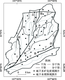
Fig. 1
Groundwater observation wells in study area"

Tab. 1
Indicator semivariogram models of groundwater depth and groundwater salinity in study area"
| 变量 | 时期 | 阈值 | 理论模型 | Co | Sill | 变程/km | Co/Sill/% |
|---|---|---|---|---|---|---|---|
| 地下水埋深/m | 节水改造前 (1998—2000年) | 1.5 | 球状模型 | 0.068 | 0.130 | 0.04 | 52.3 |
| 2.0 | 球状模型 | 0.063 | 0.135 | 0.11 | 46.5 | ||
| 2.5 | 球状模型 | 0.039 | 0.084 | 0.09 | 47.1 | ||
| 节水改造初期 (2001—2006年) | 1.5 | 球状模型 | 0.053 | 0.124 | 0.15 | 43.3 | |
| 2.0 | 球状模型 | 0.042 | 0.107 | 0.10 | 39.4 | ||
| 2.5 | 球状模型 | 0.052 | 0.151 | 0.09 | 34.4 | ||
| 节水改造中期 (2007—2012年) | 1.5 | 球状模型 | 0.060 | 0.122 | 0.10 | 49.0 | |
| 2.0 | 球状模型 | 0.044 | 0.107 | 0.09 | 41.2 | ||
| 2.5 | 球状模型 | 0.053 | 0.126 | 0.09 | 42.1 | ||
| 节水改造后期 (2013—2018年) | 1.5 | 球状模型 | 0.055 | 0.121 | 0.19 | 45.2 | |
| 2.0 | 球状模型 | 0.058 | 0.125 | 0.10 | 46.5 | ||
| 2.5 | 球状模型 | 0.061 | 0.132 | 0.09 | 45.9 | ||
| 年均 (1998—2018年) | 1.5 | 球状模型 | 0.063 | 0.147 | 0.11 | 42.7 | |
| 2.0 | 球状模型 | 0.057 | 0.121 | 0.09 | 46.5 | ||
| 2.5 | 球状模型 | 0.053 | 0.130 | 0.09 | 40.8 | ||
| 地下水矿化度/(g·L-1) | 节水改造前 (1998—2000年) | 2.0 | 球状模型 | 0.072 | 0.169 | 0.23 | 42.9 |
| 2.5 | 球状模型 | 0.073 | 0.183 | 0.44 | 40.1 | ||
| 3.0 | 球状模型 | 0.073 | 0.186 | 0.21 | 39.2 | ||
| 节水改造初期 (2001—2006年) | 2.0 | 球状模型 | 0.073 | 0.171 | 0.22 | 42.9 | |
| 2.5 | 球状模型 | 0.079 | 0.180 | 0.22 | 43.9 | ||
| 3.0 | 球状模型 | 0.071 | 0.154 | 0.60 | 46.3 | ||
| 节水改造中期 (2007—2012年) | 2.0 | 球状模型 | 0.071 | 0.177 | 0.21 | 39.9 | |
| 2.5 | 球状模型 | 0.068 | 0.155 | 0.60 | 43.6 | ||
| 3.0 | 球状模型 | 0.068 | 0.166 | 0.60 | 40.6 | ||
| 节水改造后期 (2013—2018年) | 2.0 | 球状模型 | 0.071 | 0.177 | 0.22 | 39.9 | |
| 2.5 | 球状模型 | 0.060 | 0.150 | 0.22 | 40.3 | ||
| 3.0 | 球状模型 | 0.051 | 0.130 | 0.22 | 39.2 | ||
| 年均 (1998—2018年) | 2.0 | 球状模型 | 0.069 | 0.178 | 0.21 | 38.5 | |
| 2.5 | 球状模型 | 0.066 | 0.155 | 0.22 | 42.4 | ||
| 3.0 | 球状模型 | 0.068 | 0.145 | 0.60 | 46.5 |

Fig. 2
Model building flow chart"

Tab. 2
Statistical characteristic values of groundwater depth and groundwater salinity in different periods before and after water-saving transformation"
| 变量 | 节水改造前 (1998—2000年) | 节水改造初期 (2001—2006年) | 节水改造中期 (2007—2012年) | 节水改造后期 (2013—2018年) | 年均 (1998—2018年) | |||||||||
|---|---|---|---|---|---|---|---|---|---|---|---|---|---|---|
| 范围 | 均值 | 范围 | 均值 | 范围 | 均值 | 范围 | 均值 | 范围 | 均值 | |||||
| 地下水埋深/m | 1.36~5.64 | 2.03 | 1.33~5.55 | 2.07 | 1.04~6.53 | 2.16 | 0.99~6.93 | 2.39 | 1.24~6.12 | 2.18 | ||||
| 地下水矿化度/(g·L-1) | 1.24~3.78 | 2.40 | 0.99~16.85 | 3.30 | 0.94~22.03 | 3.62 | 1.06~22.61 | 3.77 | 1.13~17.99 | 3.42 | ||||
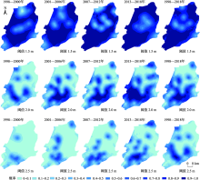
Fig. 3
Probability distribution diagram of groundwater depth with different thresholds before and after water-saving transformation"

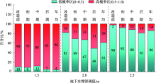
Fig. 4
Proportion composition of groundwater depth area under different thresholds"


Fig. 5
The probability distribution between the average annual groundwater depth and salinity from 1998 to 2018"


Fig. 6
Probability distribution of groundwater salinity at different thresholds"
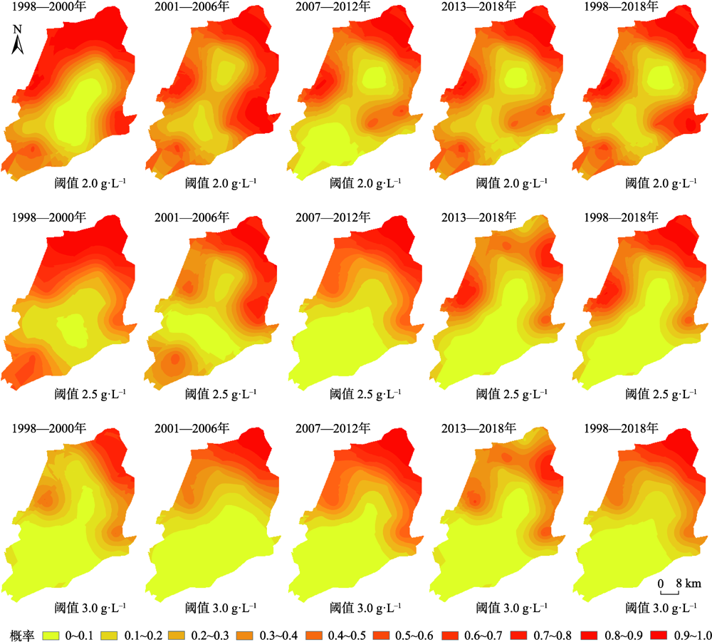

Fig. 7
Proportion composition of groundwater mineralization area under different thresholds"
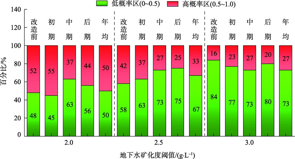
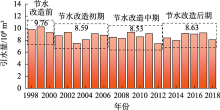
Fig. 8
Changes of irrigation water diversion in Yongji irrigation area from 1998 to 2018"

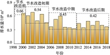
Fig. 9
Changes of irrigation displacement in Yongji irrigation area from 2000 to 2018"

| [1] | 於昊天, 马腾, 邓娅敏, 等. 江汉平原东部地区浅层地下水水化学特征[J]. 地球科学, 2017, 42(5): 685-692. |
| [ Yu Haotian, Ma Teng, Deng Yamin, et al. Hydrochemical characteristics of shallow groundwater in eastern Jianghan plain[J]. Earth Science, 2017, 42(5): 685-692. ] | |
| [2] | 艾力哈木·艾克拉木, 周金龙, 张杰, 等. 伊犁河谷西北部地下水化学特征及成因分析[J]. 干旱区研究, 2021, 38(2): 504-512. |
| [ Ailihamu Aikelamu, Zhou Jinlong, Zhang Jie, et al. Difference and consistency of responses of five sandy shrubs to changes in groundwater level in the Hailiutu River Basin[J]. Arid Zone Research, 2021, 38(2): 504-512. ] | |
| [3] | 卢龙辉, 瓦哈甫·哈力克, 彭菲, 等. 新疆克里雅绿洲地下水与表层土壤特征的最优插值[J]. 干旱区研究, 2017, 34(6): 1304-1312. |
| [ Lu Longhui, Wahap Halik, Peng Fei, et al. Optimal interpolation methods for characteristics of shallow groundwater and topsoil in the Keriya oasis, Xinjiang[J]. Arid Zone Research, 2017, 34(6): 1304-1312. ] | |
| [4] |
Ibrahimi M K, Miyazaki T, Nishimura T, et al. Contribution of shallow groundwater rapid fluctuation to soil salinization under arid and semiarid climate[J]. Arabian Journal of Geosciences, 2014, 7: 3901-3911.
doi: 10.1007/s12517-013-1084-1 |
| [5] | 吐尔逊·艾山, 塔西甫拉提·特依拜, 买买提·阿扎提, 等. 渭干河灌区地下水埋深与矿化度时空分布动态[J]. 地理科学, 2011, 31(9): 1131-1137. |
| [ Tursun Hasan, Tashoplat Tiyip, Mamat Gazat, et al. Spatial and temporal dynamic distribution of groundwater depth and mineralization in Weigan river irrigation district[J]. Scientia Geographica Sinica, 2011, 31(9): 1131-1137. ] | |
| [6] | 孟建, 姚旭擎, 杨晓琳, 等. 地下水超采区农业种植结构与作物耗水时空演变研究[J]. 农业机械学报, 2020, 51(11): 302-312. |
| [ Meng Jian, Yao Xuqing, Yang Xiaolin, et al. Spatial and temporal evolution of agricultural planting structure and crop water consumption in groundwater overdraft area[J]. Transactions of the Chinese Society for Agricultural Machinery, 2020, 51(11): 302-312. ] | |
| [7] |
Wang J Z, Wu J L, Jia H J. Analysis of spatial variation of soil salinization using a hydrochemical and stable isotopic method in a semiarid irrigated basin, Hetao plain, Inner Mongolia, North China[J]. Environmental Processes, 2016, 3: 723-733.
doi: 10.1007/s40710-016-0179-6 |
| [8] | 夏江宝, 赵西梅, 赵自国, 等. 不同潜水埋深下土壤水盐运移特征及其交互效应[J]. 农业工程学报, 2015, 31(15): 93-100. |
| [ Xia Jiangbao, Zhao Ximei, Zhao Ziguo, et al. Migration characteristics of soil water and salt and their interaction under different groundwater levels[J]. Transactions of the Chinese Society of Agricultural Engineering, 2015, 31(15): 93-100. ] | |
| [9] | 郭姝姝. 基于遥感及CLUE-S模型的内蒙古河套灌区土壤盐渍化时空演变与调控研究[D]. 北京: 中国水利水电科学研究院, 2018. |
| [ Guo Shushu. Study on Spatiotemporal Evolution and Regulation of Soil Salinization in Hetao Irrigation District, Inner Mongolia, China Using Remote Sensing and CLUE-S Model[D]. Beijing: China Institute of Water Resources and Hydropower Research, 2018. ] | |
| [10] | 刘丽娟, 李小玉. 干旱区土壤盐分积累过程研究进展[J]. 生态学杂志, 2019, 38(3): 891-898. |
| [ Liu Lijuan, Li Xiaoyu. Progress in the study of soil salt accumulation in arid region[J]. Chinese Journal of Ecology, 2019, 38(3): 891-898. ] | |
| [11] | 周利颖, 李瑞平, 苗庆丰, 等. 内蒙古河套灌区紧邻排干沟土壤盐渍化与肥力特征分析[J]. 干旱区研究, 2021, 38(1): 114-122. |
| [ Zhou Liying, Li Ruiping, Miao Qingfeng, et al. Characteristics of salinization and fertility of saline-alkali soil adjacent to drainage ditch in Hetao Irrigation Area of Inner Mongolia[J]. Arid Zone Research, 2021, 38(1): 114-122. ] | |
| [12] | 王刚. 乌梁素海生态需水及补水策略研究[D]. 郑州: 华北水利水电学院, 2012. |
| [ Wang Gang. Study on Ecological Water Demand and Water Replenishment Strategy in Wuliangsuhai[D]. Zhengzhou: North China Institute of Water Resources and Hydropower, 2012. ] | |
| [13] | 杜军, 杨培玲, 李云开, 等. 河套灌区年内地下水埋深与矿化度的时空变化[J]. 农业工程学报, 2010, 26(7): 26-31. |
| [ Du Jun, Yang Peiling, Li Yunkai, et al. Analysis of spatial and temporal variations of groundwater level and its salinity in Hetao irrigation district[J]. Transactions of the Chinese Society of Agricultural Engineering, 2010, 26(7): 26-31. ] | |
| [14] | 蔡守华, 徐英, 王俊生, 等. 土壤水分和养分时空变异性与作物产量的关系[J]. 农业工程学报, 2009, 25(12): 26-31. |
| [ Cai Shouhua, Xu Ying, Wang Junsheng, et al. Relationship between spatio-temporal variability of soil moisture and nutrients and crop yield[J]. Transactions of the Chinese Society of Agricultural Engineering, 2009, 25(12): 26-31. ] | |
| [15] | 吕建树, 张祖陆, 刘洋, 等. 日照市土壤重金属来源解析及环境风险评价[J]. 地理学报, 2012, 67(7): 971-984. |
| [ Lyu Jianshu, Zhang Zulu, Liu Yang, et al. Sources identification and hazardous risk delineation of heavy metals contamination in Rizhao City[J]. Acta Geographica Sinica, 2012, 67(7): 971-984. ] | |
| [16] | 杨奇勇, 杨劲松, 余世鹏. 禹城市耕地土壤盐分与有机质的指示克里格分析[J]. 生态学报, 2011, 31(8): 2196-2202. |
| [ Yang Qiyong, Yang Jinsong, Yu Shipeng. Evaluation on spatial distribution of soil salinity and soil organic matter by indicator Kriging in Yucheng City[J]. Acta Ecologica Sinica, 2011, 31(8): 2196-2202. ] | |
| [17] | Castrignanó A, Buttafuoco G, Giasi C. Assessment of Groundwater Salinisation Risk Using Multivariate Geostatics[D]. Soares A: Geostatistics for Environmental Applications, 2008, 15: 191-202. |
| [18] | Ducci D, De Melo M T C, Preziosi E, et al. Combining natural background levels (NBLs) assessment with indicator kriging analysis to improve groundwater quality data interpretation and management[J]. Science of the Total Environment, 2016, 569: 569-570. |
| [19] |
Demir Y, Ersahin S, Güler M, et al. Spatial variability of depth and salinity of groundwater under irrigated usti-fluvents in the Middle Black Sea Region of Turkey[J]. Environmental Monitoring and Assessment, 2009, 158: 279-294.
doi: 10.1007/s10661-008-0582-1 |
| [20] | 马金慧, 杨树青, 张武军, 等. 河套灌区节水改造对地下水环境的影响[J]. 人民黄河, 2011, 33(1): 68-69. |
| [ Ma Jinhui, Yang Shuqing, Zhang Wujun, et al. The influence of water saving transformation on groundwater environment in Hetao Irrigation District[J]. Yellow River, 2011, 33(1): 68-69. ] | |
| [21] | 孙亚楠, 李仙岳, 史海滨, 等. 基于多源数据融合的盐分遥感反演与季节差异性研究[J]. 农业机械学报, 2020, 51(6): 169-180. |
| [ Sun Yanan, Li Xianyue, Shi Haibin, et al. Remote sensing inversion of soil salinity and seasonal difference analysis based on multi-source data fusion[J]. Transactions of the Chinese Society for Agricultural Machinery, 2020, 51(6): 169-180. ] | |
| [22] |
Journel A G. Non-parametric estimation of spatial distribution[J]. Journal of Mathematical Geology, 1983, 15(3): 445-468.
doi: 10.1007/BF01031292 |
| [23] | 梅杨, 张文婷, 杨勇, 等. 基于时空指示克里格的PM2. 5不确定性分布[J]. 中国环境科学, 2018, 38(1): 35-43. |
| [ Mei Yang, Zhang Wenting, Yangyong, et al. Uncertainty assessment of PM2. 5 probability mapping by using spatio-temporal indicator Kriging[J]. China Environmental Science, 2018, 38(1): 35-43. ] | |
| [24] |
管孝艳, 王少丽, 高占义, 等. 盐渍化灌区土壤盐分的时空变异特征及其与地下水埋深的关系[J]. 生态学报, 2012, 32(4): 1202-1210.
doi: 10.5846/stxb201012281863 |
|
[ Guan Xiaoyan, Wang Shaoli, Gao Zhanyi, et al. Spatiotemporal variability of soil salinity and its relationship with the depth to groundwater in salinization irrigation district[J]. Acta Ecologica Sinica, 2012, 32(4): 1202-1210. ]
doi: 10.5846/stxb201012281863 |
|
| [25] | 李海学, 程旭学, 李林阳, 等. 宁夏海原盆地地下水淡水-微咸水分布规律[J]. 干旱区资源与环境, 2019, 33(4): 182-188. |
| [ Li Haixue, Cheng Xuxue, Li Linyang, et al. Distribution law of ground freshwater-brackishwater in the Haiyuan basin, Ningxia[J]. Journal of Arid Land Resources and Environment, 2019, 33(4): 182-188. ] | |
| [26] | 李伟. 河套灌区解放闸灌域土壤盐渍化影响因素及防治措施研究[D]. 扬州: 扬州大学, 2018. |
| [ Li Wei. Study on Influencing Factors and Prevention Measures of Soil Salinization in Jiefangzha Irrigation Field of the Hetao Irrigation District[D]. Yangzhou: Yangzhou University, 2018. ] | |
| [27] | 杨树青, 叶志刚, 史海滨, 等. 内蒙河套灌区咸淡水交替灌溉模拟及预测[J]. 农业工程学报, 2010, 26(8): 8-17. |
| [ Yang Shuqing, Ye Zhigang, Shi Haibin, et al. Simulation and prediction of rotational irrigation with salty and flesh water in the Hetao irrigation area of Inner Mongolia[J]. Transactions of the Chinese Society of Agricultural Engineering, 2010, 26(8): 8-17. ] | |
| [28] | 徐英, 葛洲, 王娟, 等. 基于指示Kriging法的土壤盐渍化与地下水埋深关系研究[J]. 农业工程学报, 2019, 35(1): 123-130. |
| [ Xu Ying, Ge Zhou, Wang Juan, et al. Study on relationship between soil salinization and groundwater table depth based on indicator Kriging[J]. Transactions of the Chinese Society of Agricultural Engineering, 2019, 35(1): 123-130. ] | |
| [29] | 周在明, 张光辉, 王金哲, 等. 环渤海低平原区土壤盐渍化风险的多元指示克立格评价[J]. 水利学报, 2011, 42(10): 1144-1151. |
| [ Zhou Zaiming, Zhang Guanghui, Wang Jinzhe, et al. Multiple indicators of soil salinization risk in the low plain area of the Bohai Sea[J]. Journal of Hydraulic Engineering, 2011, 42(10): 1144-1151. ] | |
| [30] | 张源沛, 胡克林, 李保国, 等. 银川平原土壤盐分及盐渍土的空间分布格局[J]. 农业工程学报, 2009, 25(7): 19-24. |
| [ Zhang Yuanpei, Hu Kelin, Li Baoguo, et al. Spatial distribution pattern of soil salinity and saline soil in Yinchuan plain of China[J]. Transactions of the Chinese Society of Agricultural Engineering, 2009, 25(7): 19-24. ] | |
| [31] | 赵宣, 韩霁昌, 王欢元, 等. 毛乌素沙漠-黄土高原过渡带土壤养分空间异质性[J]. 生态学报, 2016, 36(22): 7446-7452. |
| [ Zhao Xuan, Han Jichang, Wang Huanyuan, et al. Soil nutrient spatial heterogeneity in the Mu Us Desert-Loess Plateau Transition Zone[J]. Acta Ecologica Sinica, 2016, 36(22): 7446-7452. ] | |
| [32] | 郑睛之, 王楚栋, 王诗涵, 等. 典型小城市土壤重金属空间异质性及其风险评价: 以临安市为例[J]. 环境科学, 2018, 39(6): 2875-2883. |
| [ Zheng Jingzhi, Wang Chudong, Wang Shihan, et al. Spatial variation of soil heavy metals in Lin’an City and its potential risk evaluation[J]. Environmental Science, 2018, 39(6): 2875-2883. ] | |
| [33] | 刘文波, 冯翠娥, 高存荣. 河套平原地下水环境背景值[J]. 地学前缘, 2014, 21(4): 147-157. |
| [ Liu Wenbo, Feng Cui’e, Gao Cunrong, et al. Background value of groundwater environment in Hetao plain[J]. Earth Science Frontiers, 2014, 21(4): 147-157. ] | |
| [34] | 卫雄. 浅谈内蒙古河套灌区续建配套与节水改造工程存在的问题及建议[J]. 内蒙古水利, 2016(5): 40-41. |
| [ Wei Xiong. A brief discussion on the problems and suggestions on the continuation of supporting facilities and water-saving renovation projects in Hetao Irrigation District, Inner Mongolia[J]. Inner Mongolia Water Conservancy, 2016(5): 40-41. ] | |
| [35] | 张倩, 全强, 李健, 等. 河套灌区节水条件下地下水动态变化分析[J]. 灌溉排水学报, 2018, 37(增刊2): 97-101. |
| [ Zhang Qian, Quan Qiang, Li Jian, et al. Groundwater dynamic changing under water-saving irrigation conditions of Hetao Irrigation District[J]. Journal of Irrigation and Drainage, 2018, 37(Suppl. 2): 97-101. ] | |
| [36] | 马金慧. 内蒙古河套灌区不同引水水平对地下水环境变化的预测研究[D]. 呼和浩特: 内蒙古农业大学, 2010. |
| [ Ma Jinhui. Prediction and Research on the Change of Groundwater Environment on the Conditions of Different Diversion Level in Hetao Irrigation District of Inner Mongolia[D]. Hohhot: Inner Mongolia Agricultural University, 2010. ] | |
| [37] |
Bahceci I, Nacar A S. Subsurface drainage and salt leaching in irrigated land in South-east Turkey[J]. Irrigation and Drainage, 2009, 58(3): 346-356.
doi: 10.1002/ird.400 |
| [38] |
Huang G X, Liu C Y, Sun C Y, et al. A regional scale investigation on factors controlling the groundwater chemistry of various aquifers in a rapidly urbanized area: A case study of the Pearl River delta[J]. Science of the Total Environment, 2018, 625: 510-518.
doi: 10.1016/j.scitotenv.2017.12.322 |
| [39] |
Hu Q L, Yang Y H, Han S M, et al. Degradation of agricultural drainage water quantity and quality due to farmland expansion and water-saving operations in arid basins[J]. Agricultural Water Management, 2019, 213: 185-192.
doi: 10.1016/j.agwat.2018.10.019 |
| [40] |
Yan J F, Chen X, Luo G P, et al. Temporal and spatial variability response of groundwater level to land use/land cover change in oases of arid areas[J]. Chinese Science Bulletin, 2006, 51: 51-59.
doi: 10.1007/s11434-006-8207-y |
| [41] | Xiao D N, Li X Y, Song D M, et al. Temporal and spatial dynamical simulation of groundwater characteristics in Minqin Oasis[J]. Science in China Series D: Earth Sciences, 2007, 50(2): 261-273. |
| [42] |
Mi L N, Tian J C, Si J N, et al. Evolution of groundwater in Yinchuan oasis at the upper reaches of the Yellow River after water-saving transformation and its driving factors[J]. International Journal of Environmental Research and Public Health, 2020, 17(4): 1304-1321.
doi: 10.3390/ijerph17041304 |
|
||