Arid Zone Research ›› 2024, Vol. 41 ›› Issue (5): 894-904.doi: 10.13866/j.azr.2024.05.16
• Agricultural Ecology • Previous Articles
HONG Guojun1,2,3( ), XIE Junbo4, ZHANG Ling1, FAN Zhenqi2,3, YU Caili5, FU Xianbing1, LI Xu2,3()
Received:2023-10-26
Revised:2023-12-27
Online:2024-05-15
Published:2024-05-29
HONG Guojun, XIE Junbo, ZHANG Ling, FAN Zhenqi, YU Caili, FU Xianbing, LI Xu. Monitoring soil salinization of cotton fields in the Aral Reclamation Area using multispectral imaging[J].Arid Zone Research, 2024, 41(5): 894-904.
Add to citation manager EndNote|Reference Manager|ProCite|BibTeX|RefWorks
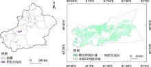
Fig. 1
Overview of the study area"


Fig. 2
Sampling points and spatial distribution of soil salinity in Alar Reclamation Area"

Tab. 1
Expression of the spectral index"
| 光谱指数 | 表达式 | 参考文献 |
|---|---|---|
| SI | [ | |
| SI1 | [ | |
| SI2 | [ | |
| SI3 | [ | |
| S1 | [ | |
| S2 | [ | |
| S3 | [ | |
| S5 | [ | |
| CRSI | [ | |
| MSAVI | [ | |
| NDVI | [ | |
| RVI | [ | |
| DVI | [ | |
| GNDVI | [ | |
| EVI | [ | |
| OSAVI | [ | |
| SAVI | [ | |
| NDWI | [ | |
| GBNDVI | [ | |
| GRNDVI | [ |
Tab. 2
Modeling combination"
| 遥感影像 | 特征选择 | 相关性(R2) | 组合 |
|---|---|---|---|
| Sentinel-2 SR | S3, GBNDVI | 0.93 | 组合1 |
| S3, GBNDVI, MSAVI, SI1 | 0.91 | 组合2 | |
| S3, EVI, GBNDVI, MSAVI | 0.90 | 组合3 | |
| Landsat-9 OLI | SI, NDVI | 0.87 | 组合1 |
| SI, SI3, NDVI | 0.85 | 组合2 | |
| SI, NDVI, GRNDVI | 0.84 | 组合3 |
Tab. 3
Analysis of conductivity training based on different models of Sentinel-2 SR images"
| 数据源 | 模型 | 机器学习模 型评价指标 | 组合1 | 组合2 | 组合3 |
|---|---|---|---|---|---|
| Sentinel-2 SR | KNN | R2 | 0.80 | 0.78 | 0.78 |
| MSE | 0.04 | 0.04 | 0.04 | ||
| MAPE | 0.15 | 0.16 | 0.16 | ||
| RF | R2 | 0.90 | 0.87 | 0.87 | |
| MSE | 0.02 | 0.02 | 0.03 | ||
| MAPE | 0.10 | 0.10 | 0.11 | ||
| DNN | R2 | 0.85 | 0.84 | 0.82 | |
| MSE | 0.03 | 0.03 | 0.03 | ||
| MAPE | 0.12 | 0.14 | 0.16 | ||
| XGB | R2 | 0.92 | 0.90 | 0.88 | |
| MSE | 0.02 | 0.02 | 0.02 | ||
| MAPE | 0.09 | 0.09 | 0.010 |
Tab. 4
Analysis of conductivity training based on different models of Landsat-9 OLI images"
| 数据源 | 模型 | 机器学习模 型评价指标 | 组合1 | 组合2 | 组合3 |
|---|---|---|---|---|---|
| Landsat-9 OLI | KNN | R2 | 0.77 | 0.76 | 0.72 |
| MSE | 0.04 | 0.04 | 0.05 | ||
| MAPE | 0.15 | 0.15 | 0.16 | ||
| RF | R2 | 0.82 | 0.81 | 0.78 | |
| MSE | 0.03 | 0.04 | 0.04 | ||
| MAPE | 0.11 | 0.12 | 0.11 | ||
| DNN | R2 | 0.81 | 0.80 | 0.76 | |
| MSE | 0.04 | 0.04 | 0.05 | ||
| MAPE | 0.14 | 0.15 | 0.16 | ||
| XGB | R2 | 0.85 | 0.84 | 0.82 | |
| MSE | 0.03 | 0.03 | 0.04 | ||
| MAPE | 0.10 | 0.11 | 0.11 |
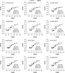
Fig. 3
Analysis of conductivity validation set models based on different models of Sentinel-2 SR images"


Fig. 4
Analysis of conductivity validation set models based on different models of Landsat-9 OLI images"

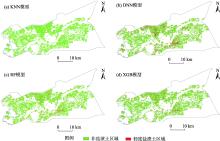
Fig. 5
Spatial inversion of saline soil in cotton fields of Alar Reclamation Area based on different models of Sentinel-2 SR images"

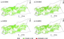
Fig. 6
Spatial inversion map of saline soil in cotton fields of Alar Reclamation Area based on different models of Landsat-9 OLI images"

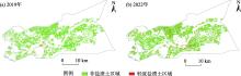
Fig. 7
Dynamic changes of soil salinization in Aral Reclamation Area from 2019 to 2022"

| [1] | 黄晶, 孔亚丽, 徐青山, 等. 盐渍土壤特征及改良措施研究进展[J]. 土壤, 2022, 54(1): 18-23. |
| [Huang Jing, Kong Yali, Xu Qingshan, et al. Progress for characteristics and amelioration measures of saline soil[J]. Soils, 2022, 54(1): 18-23.] | |
| [2] | 杨劲松, 姚荣江, 王相平, 等. 中国盐渍土研究: 历程、现状与展望[J]. 土壤学报, 2022, 59(1): 10-27. |
| [Yang Jingsong, Yao Rongjiang, Wang Xiangping, et al. Research on salt-affected soils in China: History, Status Quo and Prospect[J]. Acta Pedologica Sinica, 2022, 59(1): 10-27.] | |
| [3] | Xiao Y, Zhao G, Li T, et al. Soil salinization of cultivated land in Shandong Province, China-Dynamics during the past 40 years[J]. Land Degradation & Development, 2019, 30(4): 426-436. |
| [4] | Li J, Pu L, Han M, et al. Soil salinization research in China: Advances and prospects[J]. Journal of Geographical Sciences, 2014, 24(5): 943-960. |
| [5] | Li P, Wu J, Qian H. Regulation of secondary soil salinization in semi-arid regions: A simulation research in the Nanshantaizi area along the Silk Road, Northwest China[J]. Environmental Earth Sciences, 2016, 75: 1-12. |
| [6] | Stavi I, Thevs N, Priori S. Soil salinity and sodicity in drylands: A review of causes, effects, monitoring, and restoration measures[J]. Frontiers in Environmental Science, 2021, 330: 712831. |
| [7] | Fan J, Xu Y, Ge H, et al. Vegetation growth variation in relation to topography in Horqin Sandy Land[J]. Ecological Indicators, 2020, 113: 106215. |
| [8] | 杜瑞麒, 陈俊英, 张智韬, 等. Sentinel-2 多光谱卫星遥感反演植被覆盖下的土壤盐分变化[J]. 农业工程学报, 2021, 37(17): 107-115. |
| [Du Ruiqi, Chen Junying, Zhang Zhitao, et al. Inversing soil salinity under vegetation cover using Sentinel-2 multispectral satellite remote sensing[J]. Transactions of the Chinese Society of Agricultural Engineering, 2021, 37(17): 107-115.] | |
| [9] | Abuelgasim A, Ammad R. Mapping soil salinity in arid and semi-arid regions using Landsat 8 OLI satellite data[J]. Remote Sensing Applications: Society and Environment, 2018, 13: 415-425. |
| [10] | Wu W, Zucca C, Muhaimeed A S, et al. Soil salinity prediction and mapping by machine learning regression in Central Mesopotamia, Iraq[J]. Land Degradation & Development, 2018, 29(11): 4005-4014. |
| [11] | Wang J, Peng J, Li H, et al. soil salinity mapping using machine learning algorithms with the Sentinel-2 MSI in Arid Areas, China[J]. Remote Sensing, 2021, 13: 305. |
| [12] | Wang S, Chen Y, Wang M, et al. Performance comparison of machine learning algorithms for estimating the soil salinity of salt-affected soil using field spectral data[J]. Remote Sensing, 2018, 11(22): 2605. |
| [13] | 王遵亲, 祝寿泉, 尤文瑞, 等. 中国盐渍土[M]. 北京: 科学出版社, 1993. |
| [Wang Zunqin, Zhu Shouquan, You Wenrui, et al. Saline Soil in China[M]. Beijing: Science Press, 1993.] | |
| [14] | Staff U S S, Diagnosis and improvement of saline and alkali soils[J]. Agriculture Handbook, 1954, 60: 83-100. |
| [15] | Tamiminia H, Salehi B, Mahdianpari M, et al. Google Earth Engine for geo-big data applications: A meta-analysis and systematic review[J]. ISPRS Journal of Photogrammetry Remote Sensing, 2020, 164: 152-170. |
| [16] | 陈俊英, 王新涛, 张智韬, 等. 基于无人机-卫星遥感升尺度的土壤盐渍化监测方法[J]. 农业机械学报, 2019, 50(12):161-169. |
| [Chen Junying, Wang Xintao, Zhang Zhitao, et al. Soil salinization monitoring method based on UAV-Satellite remote sensing scale-up[J]. Transactions of the Chinese Society for Agricultural Machinery, 2019, 50(12): 161-169.] | |
| [17] | 刘旭辉, 白云岗, 柴仲平, 等. 基于多光谱遥感的典型绿洲棉田春季土壤盐分反演及验证[J]. 干旱区地理, 2022, 45(4): 1165-1175. |
| [Liu Xuhui, Bai Yungang, Chai Zhongping, et al. Inversion and validation of soil salinity based on multispectral remote sensing in typical oasis cotton field in spring[J]. Arid Land Geography, 2022, 45(4): 1165-1175.] | |
| [18] | 张术伟, 常春艳, 王卓然, 等. 基于卫星遥感的黄三角濒海区土壤水盐及其耦合关系时空分析[J]. 农业资源与环境学报, 2023, 40(4): 792-804. |
| [Zhang Shuwei, Chang Chunyan, Wang Zhuoran, et al. Spatio-temporal analysis of soil water and salt and their coupling relationship in the Yellow River Delta coastal area based on satellite remote sensing[J]. Journal of Agricultural Resources and Environment, 2023, 40(4): 792-804.] | |
| [19] | 冯娟, 丁建丽, 杨爱霞, 等. 干旱区土壤盐渍化信息遥感建模[J]. 干旱地区农业研究, 2018, 36(1): 266-273. |
| [Feng Juan, Ding Jianli, Yang Aixia, et al. Remote sensing modeling of soil salinization information in arid areas[J]. Agricultural Research in the Arid Areas, 2018, 36(1): 266-273.] | |
| [20] | 黄晓宇, 王雪梅, 卡吾恰提·白山. 基于Landsat8 OLI影像干旱区绿洲土壤含盐量反演[J]. 自然资源遥感, 2023, 35(1): 189-197. |
| [Huang Xiaoyu, Wang Xuemei, Kawuqiati Baishan, et al, Inversion of soil salinity of an oasis in an arid area based on Landsat8 OLI images[J]. Remote Sensing for Natural Resources, 2023, 35(1): 189-197.] | |
| [21] | 姚金玺, 肖成志, 张志, 等. 基于GEE多源遥感数据的干旱区植被地物类型提取[J]. 干旱区研究, 2024, 41(1): 157-168. |
| [Yao Jinxi, Xiao Chengzhi, Zhang Zhi, et al. Vegetation feature type extraction in arid regions based on GEE multi-source remote sensing data[J]. Arid Zone Research, 2024, 41(1): 157-168.] | |
| [22] | Guo B, Lu M, Fan Y, et al. A novel remote sensing monitoring index of salinization based on three-dimensional feature space model and its application in the Yellow River Delta of China[J]. Geomatics, Natural Hazards and Risk, 2023, 14(1): 95-116. |
| [23] | 代云豪, 管瑶, 张钦凯, 等. 阿拉尔垦区土壤盐渍化遥感监测及时空特征分析[J]. 干旱区地理, 2022, 45(4): 1176-1185. |
| [Dai Yunhao, Guan Yao, Zhang Qinkai, et al, Remote sensing monitoring and temporal and spatial characteristics of soil salinization in Aral Reclamation Area[J]. Arid Land Geography, 2022, 45(4): 1176-1185.] | |
| [24] | 马浩文, 王永芳, 郭恩亮. 基于GEE的翁牛特旗土地沙漠化遥感监测[J]. 干旱区研究, 2023, 40(3): 504-516. |
| [Ma Haowen, Wang Yongfang, Guo Enliang. Remote sensing monitoring of aeolian desertification in Ongniud Banner based on GEE[J]. Arid Land Geography, 2023, 40(3): 504-516.] | |
| [25] | 谢俊博, 王兴鹏, 何帅, 等. 基于光谱指数建模的沙井子灌区土壤盐分反演[J]. 干旱区地理, [2024-02-05]. http://kns.cnki.net/kcms/detail/65.1103.X.20240202.1806.002.html. |
| [Xie Junbo, Wang Xingpeng, He Shuai, et al. Soil salinity inversion in the Shajingzi irrigation scheme based on spectral index modeling[J]. Arid Land Geography, [2024-02-05]. http://kns.cnki.net/kcms/detail/65.1103.X.20240202.1806.002.html.] | |
| [26] | LMa S, He B, Xie B, et al. Investigation of the spatial and temporal variation of soil salinity using Google Earth Engine: A case study at Werigan-Kuqa Oasis, West China[J]. Scientific Reports, 2023, 13(1): 2754. |
| [27] | Hong G, Bai T, Wang X, et al. Extraction and analysis of soil salinization information in an Alar Reclamation Area based on spectral index modeling[J]. Applied Sciences, 2023, 13(6): 3440. |
| [28] | Moltó E. Fusion of different image sources for improved monitoring of agricultural plots[J]. Sensors, 2022, 22(17): 6642. |
| [29] |
朱大运, 熊康宁, 肖华, 等. 基于植被指数的GF-1与Landsat-OLI石漠化识别能力对比评价[J]. 自然资源学报, 2016, 31(11): 1949-1957.
doi: 10.11849/zrzyxb.20151393 |
|
[Zhu Dayun, Xiong Kangning, Xiao Hua, et al, Comparison of rocky desertification detection ability of GF-1 and Landsat-OLI based on vegetation index[J]. Journal of Natural Resources, 2016, 31(11): 1949-1957.]
doi: 10.11849/zrzyxb.20151393 |
|
| [30] |
Lobell D B, Lesch S M, Corwin D L, et al. Regional-scale assessment of soil salinity in the Red River Valley using multi-year MODIS EVI and NDVI[J]. Journal of Environmental Quality, 2010, 39(1): 35-41.
doi: 10.2134/jeq2009.0140 pmid: 20048292 |
| [31] | 李小雨, 贾科利, 魏慧敏, 等. 基于随机森林算法的土壤含盐量预测[J]. 干旱区研究, 2023, 40(8): 1258-1267. |
| [Li Xiaoyu, Jia Keli, Wei Huimin, et al, Prediction of soil salt content based on the random forest algorithm[J]. Arid Land Geography, 2023, 40(8): 1258-1267.] | |
| [32] | 李霞, 刘廷玺, 段利民, 等. 半干旱区沙丘、草甸作物系数模拟及蒸散发估算[J]. 干旱区研究, 2020, 37(5):1246-1255. |
| [Li Xia, Liu Tingxi, Duan Limin, et al, Crop coefficient simulation and evapotranspiration estimation of dune and meadow in a semiarid area[J]. 2020, 37(5): 1246-1255.] | |
| [33] | Gao B C. NDWI—A normalized difference water index for remote sensing of vegetation liquid water from space[J]. Remote Sensing of Environment, 1996, 58(3): 257-266. |
| [34] | Zhao X, Zhao Z, Zhao F, et al. An estimation of the leaf nitrogen content of apple tree canopies based on multispectral unmanned aerial vehicle imagery and machine learning methods[J]. Agronomy, 2024, 14(3): 552. |
| [35] | Naimi S, Ayoubi S, Zeraatpisheh M, et al. Ground observations and environmental covariates integration for mapping of soil salinity: a machine learning-based approach[J]. Remote Sensing, 2021, 13(23): 4825. |
| [36] | Taşan M, Taşan S, Demir Y. Estimation and uncertainty analysis of groundwater quality parameters in a coastal aquifer under seawater intrusion: a comparative study of deep learning and classic machine learning methods[J]. Environmental Science and Pollution Research, 2023, 30(2): 2866-2890. |
| [1] | XIAO Sentian, Ilyas NURMEMET, Nuerbiye MUHETAER, Zhao Jing, Adilai ABULAITI. Spatial and temporal analysis of soil salinity in Yutian Oasis by combined optical and radar multi-source remote sensing [J]. Arid Zone Research, 2023, 40(1): 59-68. |
| [2] | SU Chunli,JI Qiannan,TAO Yanzhen,XIE Xianjun,PAN Hongjie. Differentiation characteristics and main influencing factors of soil salinization in the West of Hetao Irrigation Area [J]. Arid Zone Research, 2022, 39(3): 916-923. |
| [3] | BAI Jianduo,PENG Jie,SHI Zhou,WANG Yuzhen,LIU Weiyang,LI Hongyi. Precise management zoning in arid soil croplands based on multi-source data [J]. Arid Zone Research, 2022, 39(2): 646-655. |
| [4] | SONG Qi,SHI Zhou,FENG Chunhui,MA Ziqiang,JI Wenjun,PENG Jie,GAO Qi,JIANG Xuewei. Analysis of landscape pattern from 1990 to 2019 based on multi-temporal imagery in arid oasis [J]. Arid Zone Research, 2022, 39(2): 594-604. |
| [5] | YANG Si-cun, CHE Zong-xian, WANG Cheng-bao, HUO Lin , JIANG Wan-li. Soil Salinization and Its Causes in the Irrigated Areas along the Yellow River in Gansu Province [J]. , 2014, 31(1): 57-64. |
| [6] | CHEN Chun-Xiu, TIAN Chang-Yan. Relationship between Osmotic Potential and Total Salt Content in Saline or Alkaline Soil in Xinjiang [J]. , 2013, 30(6): 998-1003. |
| [7] | DU Hai-Yan, ZHOU Zhi-Bin, LIU Feng-Shan, YAN Bing. Variation of Fractal Dimension of Soil Particle Size Distribution in the Aral Reclamation Area in Oasis Development [J]. , 2013, 30(4): 615-622. |
| [8] | CHEN Dong-Qiang, WANG Rang-Hui. Total Soil Salinity in Artificial Forest in the Junggar Basin Based on Hyperspectrum [J]. , 2013, 30(3): 444-448. |
| [9] | JI Li-Li-?A-Bu-Du-Wai-Li, A Yi-Gu-Li-?Mai-Mai-Ti, TANG Yang. Soil Salinization in the Manas River Basin in Spring [J]. , 2013, 30(2): 189-195. |
| [10] | CUI Yong-qin, MA Jian-ying, SUN Wei, LIU Xiao-ning, WANG Shao-ming. Application of Stable Isotope Techniques in the Study on Soil Salinization [J]. , 2011, 28(3): 401-407. |
|
||