Arid Zone Research ›› 2022, Vol. 39 ›› Issue (2): 646-655.doi: 10.13866/j.azr.2022.02.31
• Others • Previous Articles Next Articles
BAI Jianduo1( ),PENG Jie1(),SHI Zhou2,WANG Yuzhen1,LIU Weiyang1,LI Hongyi3
Received:2021-08-21
Revised:2021-12-03
Online:2022-03-15
Published:2022-03-30
Contact:
Jie PENG
E-mail:bjdzky@163.com;pjzky@163.com
BAI Jianduo,PENG Jie,SHI Zhou,WANG Yuzhen,LIU Weiyang,LI Hongyi. Precise management zoning in arid soil croplands based on multi-source data[J].Arid Zone Research, 2022, 39(2): 646-655.
Add to citation manager EndNote|Reference Manager|ProCite|BibTeX|RefWorks
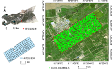
Fig. 1
Location of the study area and distribution of sample points"

Tab. 1
Descriptive statistics of apparent electrical conductivity at different depths"
| 表观电导率 | 最小值/(mS·m-1) | 最大值/(mS·m-1) | 平均值/(mS·m-1) | 变异系数/% | 峰度 | 偏度 |
|---|---|---|---|---|---|---|
| ECh0.375 | 2.39 | 300.98 | 59.39 | 81.82 | 1.54 | 1.87 |
| ECh0.75 | 3.23 | 287.15 | 55.58 | 71.95 | 1.32 | 1.83 |
| ECv0.75 | 1.17 | 280.04 | 54.67 | 74.52 | 1.16 | 1.72 |
| ECv1.5 | 2.24 | 290.43 | 54.19 | 78.97 | 2.82 | 1.02 |
Tab. 2
Spatial heterogeneity analysis of apparent electrical conductivity at different depths"
| 表观电导率 | 模型 | 块金值 | 基台值 | 块金值/基台值/% | 变程/m | 决定系数 | 残差 |
|---|---|---|---|---|---|---|---|
| ECh0.375 | 指数 | 5.33 | 10.79 | 49.38 | 2579.00 | 0.96 | 0.92 |
| ECh0.75 | 指数 | 3.59 | 7.18 | 49.99 | 2148.00 | 0.94 | 0.68 |
| ECv0.75 | 指数 | 4.82 | 9.64 | 49.99 | 2067.00 | 0.94 | 1.27 |
| ECv1.5 | 指数 | 3.05 | 6.27 | 48.61 | 1383.00 | 0.93 | 0.52 |
Tab. 3
Correlation analysis table of apparent electrical conductivity with spectral index and DEM data"
| 光谱指数及地形数据 | 相关系数 | 计算公式 | |
|---|---|---|---|
| 植被指数 | 比值植被指数(RVI) | -0.11** | NIR/R |
| 差值植被指数(DVI) | -0.02 | NIR-R | |
| 绿度差值植被指数(GDVI) | -0.02 | NIR-G | |
| 绿度比值植被指数(GRVI) | -0.12** | NIR/G | |
| 归一化植被指数(NDVI) | -0.09** | (NIR-R)/(NIR+R) | |
| 增强植被指数(EVI) | -0.11** | 2.5×(NIR-R)/(NIR+6×R-7.5×B+1) | |
| 近红外归一化(NNIR) | -0.09** | NIR/(NIR+R+G) | |
| 红光归一化指数(NR) | -0.09** | R/(NIR+R+G) | |
| 绿光归一化指数(NG) | 0.09** | G/(NIR+R+G) | |
| 土壤盐分指数 | 归一化差值盐分指数(NDSI) | 0.11** | (R-NIR)/(R+NIR) |
| 盐渍化指数1(S1) | 0.02 | B/R | |
| 盐渍化指数2(S2) | 0.03 | (B-R)/(B+R) | |
| 盐渍化指数3(S3) | 0.07* | (G×R)/B | |
| 盐渍化指数5(S5) | 0.10** | (B×R)/G | |
| 盐渍化指数6(S6) | -0.03 | (R×NIR)/G | |
| 盐渍化指数(SI-T) | 0.10** | (R/NIR)×100 | |
| 盐分指数(SI) | 0.08* | SQRT(B×R) | |
| 盐分指数1(SI1) | 0.07* | SQRT(G×R) | |
| 盐分指数2(SI2) | 0.04 | SQRT(G^2+R^2+NIR^2) | |
| 盐分指数3(SI3) | 0.07* | SQRT(G^2+R^2) | |
| 强度指数1(Int1) | 0.07* | (G+R)/2 | |
| 强度指数2(Int2) | 0.05 | (G+R+NIR)/2 | |
| 地形数据 | 地形数据(DEM) | -0.01 | - |
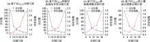
Fig. 2
Segmentation evaluation index"
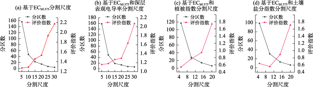
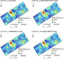
Fig. 3
Optimal management zones under different variables"

Tab. 4
Partition evaluation based on different dataset"
| 分区信息 | 分区内变异系数/% | 分区间莫兰指数 |
|---|---|---|
| ECh0.375 | 13.60 | 0.1281 |
| ECh0.375+深层表观电导率 | 15.84 | 0.0075 |
| ECh0.375+植被指数 | 18.65 | 0.0184 |
| ECh0.375+土壤盐分指数 | 16.30 | 0.0168 |
| [1] | 杨劲松. 中国盐渍土研究的发展历程与展望[J]. 土壤学报, 2008, 45(5):837-845. |
| [ Yang Jingsong. Development and prospect of the research on salt-affected soils in China[J]. Acta Pedologica Sinica, 2008, 45(5):837-845. ] | |
| [2] | Maas E V, Hoffman G J. Crop salt tolerance: Evaluation of existing data[C]// Managing Saline Water for Irrigation. Proceedings of the International Salinity Conference, 1977. |
| [3] |
Serrano J, Shahidian S, Marques da Silva J, et al. Mapping management zones based on soil apparent electrical conductivity and remote sensing for implementation of variable rate irrigation: Case study of corn under a center pivot[J]. Water, 2020, 12(12):3427.
doi: 10.3390/w12123427 |
| [4] | 刘焕军, 殷悦, 鲍依临, 等. 黑土区田块尺度精准管理遥感分区时空格局与成因分析[J]. 农业工程学报, 2021, 37(3):147-154. |
| [ Liu Huanjun, Yin Yue, Bao Yilin, et al. Spatial-temporal pattern and cause analysis for accurate management of remote sensing zoning at field scale in black soil areas[J]. Transactions of the Chinese Society of Agricultural Engineering, 2021, 37(3):147-154. ] | |
| [5] |
Haghverdi A, Leib B G, Washington-Allen R A, et al. Perspectives on delineating management zones for variable rate irrigation[J]. Computers and Electronics in Agriculture, 2015, 117:154-167.
doi: 10.1016/j.compag.2015.06.019 |
| [6] |
Córdoba M, Bruno C, Costa J, et al. Subfield management class delineation using cluster analysis from spatial principal components of soil variables[J]. Computers and Electronics in Agriculture, 2013, 97:6-14.
doi: 10.1016/j.compag.2013.05.009 |
| [7] | 李茂娜, 孙宇, 严海军, 等. 基于土壤表观电导率的变量灌溉管理分区方法[J]. 农业工程学报, 2020, 36(22):172-180. |
| [ Li Maona, Sun Yu, Yan Haijun, et al. Method for variable rate irrigation management zone delineation based on apparent soil electrical conductivity[J]. Transactions of the Chinese Society of Agricultural Engineering, 2020, 36(22):172-180. ] | |
| [8] | 朱昌达, 高明秀, 王文倩, 等. 基于GIS的滨海盐渍化农田土壤空间变异及其分区管理[J]. 生态学报, 2020, 40(19):6982-6990. |
| [ Zhu Changda, Gao Mingxiu, Wang Wenqian, et al. Spatial variability and zoning management of coastal salinized farmland soil based on GIS[J]. Acta Ecologica Sinica, 2020, 40(19):6982-6990. ] | |
| [9] |
Zeraatpisheh M, Bakhshandeh E, Emadi M, et al. Integration of PCA and fuzzy clustering for delineation of soil management zones and cost-efficiency analysis in a citrus plantation[J]. Sustainability, 2020, 12(14):5809.
doi: 10.3390/su12145809 |
| [10] |
Karydas C, Iatrou M, Iatrou G, et al. Management zone delineation for site-specific fertilization in rice crop using multi-temporal rapidEye imagery[J]. Remote Sensing, 2020, 12(16):2604.
doi: 10.3390/rs12162604 |
| [11] | 刘焕军, 邱政超, 孟令华, 等. 黑土区田块尺度遥感精准管理分区[J]. 遥感学报, 2017, 21(3):470-478. |
| [ Liu Huanjun, Qiu Zhengchao, Meng Linghua, et al. Site-specific management zone of field scale based on remote sensing image in a black soil area[J]. National Remote Sensing Bulletin, 2017, 21(3):470-478. ] | |
| [12] |
Damian J M, Pias O H C, Cherubin M R, et al. Applying the NDVI from satellite images in delimiting management zones for annual crops[J]. Scientia Agricola, 2020, 77(1):0055. doi: 10.1590/1678-992X-2018-0055.
doi: 10.1590/1678-992X-2018-0055 |
| [13] | 刘焕军, 鲍依临, 徐梦园, 等. 基于SOM和NDVI的黑土区精准管理分区对比[J]. 农业工程学报, 2019, 35(13):177-183. |
| [ Liu Huanjun, Bao Yilin, Xu Mengyuan, et al. Comparison of precision management zoning methods in black soil area based on SOM and NDVI[J]. Transactions of the Chinese Society of Agricultural Engineering, 2019, 35(13):177-183. ] | |
| [14] | 周林虎, 王昊宇, 张秉来, 等. 硫酸盐渍土表观电导率与水分、盐分及粒径关系研究[J]. 干旱区研究, 2021, 38(4):1020-1030. |
| [ Zhou Linhu, Wang Haoyu, Zhang Binglai, et al. The relationship between ECa of sulfate saline soil and moisture content, salt content, and particle size[J]. Arid Zone Research, 2021, 38(4):1020-1030. ] | |
| [15] |
Moral F J, Terrón J M, Da Silva J R M. Delineation of management zones using mobile measurements of soil apparent electrical conductivity and multivariate geostatistical techniques[J]. Soil and Tillage Research, 2010, 106(2):335-343.
doi: 10.1016/j.still.2009.12.002 |
| [16] |
Rhoades J D, van Schilfgaarde J. An electrical conductivity probe for determining soil salinity[J]. Soil Science Society of America Journal, 1976, 40(5):647-651.
doi: 10.2136/sssaj1976.03615995004000050016x |
| [17] |
Rhoades J D, Lesch S M, LeMert R D, et al. Assessing irrigation/drainage/salinity management using spatially referenced salinity measurements[J]. Agricultural Water Management, 1997, 35(1-2):147-165.
doi: 10.1016/S0378-3774(97)00017-6 |
| [18] |
Yao R J, Yang J S, Liu G M. Calibration of soil electromagnetic conductivity in inverted salinity profiles with an integration method[J]. Pedosphere, 2007, 17(2):246-256.
doi: 10.1016/S1002-0160(07)60031-9 |
| [19] |
Tetteh G O, Gocht A, Conrad C. Optimal parameters for delineating agricultural parcels from satellite images based on supervised Bayesian optimization[J]. Computers and Electronics in Agriculture, 2020, 178:105696.
doi: 10.1016/j.compag.2020.105696 |
| [20] |
Benz U C, Hofmann P, Willhauck G, et al. Multi-resolution, object-oriented fuzzy analysis of remote sensing data for GIS-ready information[J]. ISPRS Journal of Photogrammetry and Remote Sensing, 2004, 58(3-4):239-258.
doi: 10.1016/j.isprsjprs.2003.10.002 |
| [21] |
Chang D, Zhang J, Zhu L, et al. Delineation of management zones using an active canopy sensor for a tobacco field[J]. Computers and Electronics in Agriculture, 2014, 109:172-178.
doi: 10.1016/j.compag.2014.09.019 |
| [22] | 陈春雷, 武刚. 面向对象的遥感影像最优分割尺度评价[J]. 遥感技术与应用, 2011, 26(1):96-102. |
| [ Chen Cunlei, Wu Gang. Evaluation of optimal segmentation scale with object-oriented method in remote sensing[J]. Remote Sensing Technology and Application, 2011, 26(1):96-102. ] | |
| [23] | 彭杰. 荒漠土壤盐渍化遥感监测与开垦方案分析——以空台里克冲积扇为例[D]. 杭州: 浙江大学, 2019. |
| [ Peng Jie. Salinzation Monitoring and Reclamation Strategy Analysis in of Desert Soil Using Remote Sensing: A Case Study in the Kongtailike Alluvial Fan[D]. Hangzhou: Zhejiang University, 2019. ] | |
| [24] | 刘宁. 不同土地利用方式下黄河三角洲土壤特性空间变异研究[D]. 泰安: 山东农业大学, 2007. |
| [ Liu Ning. Spatial Variability of Soil Characteristics on Different Land Use Types in the Yellow River Delta[D]. Tai’an: Shandong Agricultural University, 2007. ] | |
| [25] | 白建铎, 彭杰, 白子金, 等. 干旱区棉田表层土壤盐渍化时空变异研究[J]. 土壤通报, 2021, 52(3):527-534. |
| [ Bai Jianduo, Peng Jie, Bai Zijin, et al. Clarifying spatial-temporal variability of surface soil salinization in arid cotton fields[J]. Chinese Journal of Soil Science, 2021, 52(3):527-534. ] | |
| [26] | 许盼盼. 基于高时空分辨率数据的湿地精细分类研究[D]. 北京: 中国科学院大学, 2018. |
| [ Xu Panpan. Study on Finer Mapping of Wetlands Based on High Temporal and High Spatial Resolution Date[D]. Beijing: University of Chinese Academy of Sciences, 2018. ] | |
| [27] | 黄万里. 基于高分卫星数据多尺度图像分割方法的天山森林小班边界提取研究[D]. 福州: 福建师范大学, 2015. |
| [ Huang Wanli. Study on Sub-compartment Division of Tiansan Forest Based on High Spatial Resolution Satellite Images and Multi-Scale Image Segmentation Methods[D]. Fuzhou: Fujian Normal University, 2015. ] |
| [1] | LYU Zhuangzhuang, QIAO Qingqing, DONG Sunyi, WANG Dong. Paleoclimatic evolution and driving mechanisms in arid areas of inland Asia during the Middle Miocene Climatic Optimum in the context of global climate warming [J]. Arid Zone Research, 2024, 41(8): 1309-1322. |
| [2] | WANG Yiwen, MA Yaoyao, SHI Peijun, ZHANG Gangfeng. The impact of photovoltaic power plant operation on local ecological environments in arid areas [J]. Arid Zone Research, 2024, 41(8): 1423-1433. |
| [3] | LONG Weiyi, SHI Jianfei, LI Shuangyuan, SUN Jinjin, WANG Yugang. Evaluation of multimodel inversion effects on soil salinity in oasis basin [J]. Arid Zone Research, 2024, 41(7): 1120-1130. |
| [4] | YE Hu, PEI Hao, JIANG Yanfeng, NA Qing, ZHANG Liwei. Properties of aerosol scattering and its influencing factors in semiarid areas of Inner Mongolia [J]. Arid Zone Research, 2024, 41(5): 730-741. |
| [5] | HONG Guojun, XIE Junbo, ZHANG Ling, FAN Zhenqi, YU Caili, FU Xianbing, LI Xu. Monitoring soil salinization of cotton fields in the Aral Reclamation Area using multispectral imaging [J]. Arid Zone Research, 2024, 41(5): 894-904. |
| [6] | YUAN Ping, HAN Huan, ZHAO Hongmei, LI Congjuan. Effects of bare versus sand burial on the decomposition and nutrient release of apophyges in extremely arid zones [J]. Arid Zone Research, 2024, 41(2): 293-300. |
| [7] | WANG Xiang, LYU Haishen, ZHU Yonghua, GUO Chenyu. Application and comparison of two channel flood routing methods in Xinjiang mountainous areas [J]. Arid Zone Research, 2023, 40(8): 1240-1247. |
| [8] | LU Yuanbo, YAN Cheng, SONG Chunwu, LI Yajuan, LAI Zhaoyun. Response of plant community distribution in the pre-montane desert grassland on the southern slope of Tianshan Mountain to environmental factors: A case study in Baicheng County [J]. Arid Zone Research, 2023, 40(8): 1346-1357. |
| [9] | MENG Na, ZHANG Ying. Identification of priority areas for forest land expansion in Shanxi Province [J]. Arid Zone Research, 2023, 40(1): 111-122. |
| [10] | XIAO Sentian, Ilyas NURMEMET, Nuerbiye MUHETAER, Zhao Jing, Adilai ABULAITI. Spatial and temporal analysis of soil salinity in Yutian Oasis by combined optical and radar multi-source remote sensing [J]. Arid Zone Research, 2023, 40(1): 59-68. |
| [11] | PANG Haiwei,YU Dian,REN Chengbao,ZHANG Yu,ZHENG Caizhi,GUO Jiacheng,BIAN Zhen,SANG Guoqing. Remote sensing classification characteristics of typical plant communities in the semi-arid areas of eastern Ningxia [J]. Arid Zone Research, 2022, 39(6): 1930-1941. |
| [12] | LUO Chengyan,CHEN Fulong,HE Chaofei,LONG Aihua,QIAO Changlu. Applicability of CMADS in runoff simulation of Yulong Kashi River [J]. Arid Zone Research, 2022, 39(4): 1090-1101. |
| [13] | LU Fangyuan,JIA Debin,GAO Ruizhong,SU Wenxu,ZHAO Hang,YANG Li’na. Dynamic simulation and carrying capacity analysis of a water resource system in Kubuqi Desert [J]. Arid Zone Research, 2022, 39(4): 1102-1111. |
| [14] | SU Chunli,JI Qiannan,TAO Yanzhen,XIE Xianjun,PAN Hongjie. Differentiation characteristics and main influencing factors of soil salinization in the West of Hetao Irrigation Area [J]. Arid Zone Research, 2022, 39(3): 916-923. |
| [15] | WANG Xuyang,LI Dianpeng,SUN Tao,SUN Xia,JIA Hongtao,LI Jun,LI Xinhu. Effects of soil mulching on the greenhouse gas emissions of crops farmland in an arid area of Xinjiang [J]. Arid Zone Research, 2022, 39(1): 176-184. |
|
||