Arid Zone Research ›› 2023, Vol. 40 ›› Issue (8): 1240-1247.doi: 10.13866/j.azr.2023.08.04
• Land and Water Resources • Previous Articles Next Articles
WANG Xiang1,2( ),LYU Haishen1,2(),ZHU Yonghua1,2,GUO Chenyu1,2
Received:2022-11-14
Revised:2023-06-08
Online:2023-08-15
Published:2023-08-24
WANG Xiang, LYU Haishen, ZHU Yonghua, GUO Chenyu. Application and comparison of two channel flood routing methods in Xinjiang mountainous areas[J].Arid Zone Research, 2023, 40(8): 1240-1247.
Add to citation manager EndNote|Reference Manager|ProCite|BibTeX|RefWorks
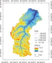
Fig. 1
Schematic diagram of the watershed of the study area"

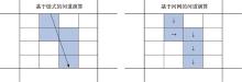
Fig. 2
Channel routing on a vector/link network (left)or via the high-resolution grid (right)"

Tab. 1
Parameters’ range and calibration results of WRF-Hydro model"
| 参数 | 参数含义 | 参数范围[ | 率定结果 |
|---|---|---|---|
| REFKDT | 径流入渗参数 | 0.6~6.0 | 2.5 |
| SLOPE | 深层排水系数 | 0.0~1.0 | 0.2 |
| MANNFAC | 河道曼宁糙率乘子 | 0.3~2.0 | 0.9 |

Fig. 3
Simulation results driven by data"

Tab. 2
Flow simulation results using different method"
| 模式 | 年份 | NSE | MRE/% | R2 | 用时 |
|---|---|---|---|---|---|
| 马斯京根-康吉 | 2016年 | 0.667 | 3.89 | 0.688 | 112 min |
| 2017年 | 0.631 | 9.81 | 0.695 | ||
| 2018年 | 0.638 | 7.41 | 0.678 | ||
| 2019年 | 0.591 | 5.99 | 0.685 | ||
| 扩散波 | 2016年 | 0.652 | 3.51 | 0.696 | 296 min |
| 2017年 | 0.663 | 9.88 | 0.722 | ||
| 2018年 | 0.665 | 3.49 | 0.678 | ||
| 2019年 | 0.658 | 5.80 | 0.747 |
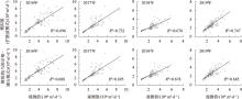
Fig. 4
R-square values for the different flood routing models and years"

Tab. 3
Accuracy analysis of hydrological model"
| 演进方法 | 洪水场次 | 实测洪峰 /(m3·s-1) | 预测洪峰 /(m3·s-1) | 洪峰相对误差/% | 精度评价 |
|---|---|---|---|---|---|
| 扩散波法 | 1 | 103 | 105.62 | 2.54 | √ |
| 2 | 151 | 152.64 | 1.09 | √ | |
| 3 | 89.47 | 96.29 | 7.62 | - | |
| 4 | 129 | 123.92 | 3.94 | √ | |
| 马斯京根-康吉法 | 1 | 103 | 103.31 | 0.30 | √ |
| 2 | 151 | 145.76 | 3.47 | √ | |
| 3 | 89.47 | 97.22 | 8.66 | - | |
| 4 | 129 | 121.04 | 6.17 | - |
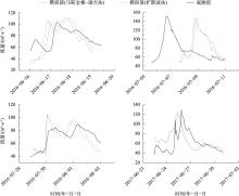
Fig. 5
The flood hydrograph"

| [1] | 夏军. 水文学科发展与思考[J]. 中国科学基金, 2000(5): 39-43. |
| [ Xia Jun. Perspective and ponderaction in hydrological science[J]. Bulletin of National Natural Science Foundation of China, 2000(5): 39-43. ] | |
| [2] | Nikoo M, Ramezani F, Hadzima-Nyarko M, et al. Flood-routing modeling with neural network optimized by social-based algorithm[J]. Natural Hazards, 2016, 82(1): 1-24. |
| [3] | Usda. National Engineering Handbook, Section 4: Hydrology Chapter 17 Flood Routing[M]. Washington, DC. 1972: 2-4. |
| [4] | 陈亚宁, 杨青, 罗毅, 等. 西北干旱区水资源问题研究思考[J]. 干旱区地理, 2012, 35(1): 1-9. |
| [ Chen Yaning, Yang Qing, Luo Yi, et al. Ponder on the issues of water resources in the arid region of northwest China[J]. Arid Land Geography, 2012, 35(1): 1-9. ] | |
| [5] | 穆振侠. 天山西部山区分布式水文模型的研究[D]. 乌鲁木齐: 新疆农业大学, 2007. |
| [ Mu Zhenxia. Research on Distributed Hydrological Model in Western Tianshan Moutains[D]. Urumqi: Xinjiang Agricultural University, 2007. ] | |
| [6] | 孟伟, 张远, 郑丙辉. 辽河流域水生态分区研究[J]. 环境科学学报, 2007, 27(6): 911-918. |
| [ Meng Wei, Zhang Yuan, Zheng Binghui. Study of aquatic eco region in Liao River Basin[J]. Acta Scientiae Circumstantiae, 2007, 27(6): 911-918. ] | |
| [7] | 陈庭兴, 吕海深, 朱永华. 基于GEV分布的西营河流域洪水特性分析[J]. 干旱区研究, 2021, 38(6): 1563-1569. |
| [ Chen Tingxing, Lyu Haishen, Zhu Yonghua. Analysis of flood characteristics in Xiying River Basin based on GEV distribution[J]. Arid Zone Research, 2021, 38(6): 1563-1569. ] | |
| [8] |
刘玉环, 李致家, 刘志雨, 等. 半湿润半干旱流域空间组合模型研究[J]. 湖泊科学, 2020, 32(3): 826-839.
doi: 10.18307/2020.0322 |
|
[ Liu Yuhuan, Li Zhijia, Liu Zhiyu, et al. Spatial combination model for semi-humid and semi-arid watersheds[J]. Journal of Lake Sciences, 2020, 32(3): 826-839. ]
doi: 10.18307/2020.0322 |
|
| [9] | 刘昱辰, 刘佳, 李传哲, 等. WRF-Hydro模式在水文模拟与预报应用中的研究进展[J]. 水电能源科学, 2019, 37(11): 1-5. |
| [ Liu Yuchen, Liu Jia, Li Chuanzhe, et al. Advances of WRF-Hydro and its application in hydrological simulation and forecasting[J]. Water Resources and Power, 2019, 37(11): 1-5. ] | |
| [10] | 刘洪波, 菅浩然, 孙明坤. WRF-Hydro模型在典型中小流域的日径流模拟研究[J]. 水文, 2021, 41(4): 48-55. |
| [ Liu Hongbo, Jian Haoran, Sun Mingkun. Daily discharge simulation of small and medium-sized humid and semi-humid basins using WRF-Hydro model[J]. Journal of China Hydrology, 2021, 41(4): 48-55. ] | |
| [11] |
Sun M, Li Z, Yao C, et al. Evaluation of flood prediction capability of the WRF-Hydro model based on multiple forcing scenarios[J]. Water, 2020, 12(3): 874.
doi: 10.3390/w12030874 |
| [12] |
Davy Q G M L, Joël A, Browne K N A, et al. Potential of the coupled WRF/WRF-Hydro modeling system for flood forecasting in the Ouémé River (West Africa)[J]. Water, 2022, 14(8): 1192.
doi: 10.3390/w14081192 |
| [13] | 王岚, 刘志辉, 姚俊强, 等. 1978—2011年呼图壁河径流的变化趋势[J]. 水土保持通报, 2015, 35(3): 62-67. |
| [ Wang Lan, Liu Zhihui, Yao Junqiang, et al. Runoff variation trend of Hutubi River during 1978-2011[J]. Bulletin of Soil and Water Conservation, 2015, 35(3): 62-67. ] | |
| [14] | 耿峻岭, 高玲, 陈建江, 等. 新疆呼图壁河流域水文特征分析[J]. 干旱区研究, 2005, 22(3): 371-376. |
| [ Geng Junling, Gao Ling, Chen Jianjiang, et al. Analysis on the hydrological characteristics in the Hutubi River Basin, Xinjiang[J]. Arid Zone Research, 2005, 22(3): 371-376. ] | |
| [15] |
Shen Y, Xiong A. Validation and comparison of a new gauge-based precipitation analysis over mainland China[J]. International Journal of Climatology, 2016, 36(1): 252-265.
doi: 10.1002/joc.4341 |
| [16] | 孙铭悦, 吕海深, 朱永华, 等. 2套气象数据在资料缺乏地区的适用性评估——以呼图壁河流域为例[J]. 干旱区研究, 2022, 39(1): 94-103. |
| [ Sun Mingyue, Lyu Haishen, Zhu Yonghua, et al. Applicability assessment of two meteorological datasets in areas lacking data with the Hutubi River Basin as an example[J]. Arid Zone Research, 2022, 39(1): 94-103. ] | |
| [17] | 朱仟. 气候变化下降水输入和水文模型参数对水文模拟的影响[D]. 杭州: 浙江大学, 2017. |
| [ Zhu Qian. Effects of Precipitation Products and Parameters in Hydrological Model on Hydrological Simulation under Climate Change[D]: Hangzhou: Zhejiang University, 2017. ] | |
| [18] |
Ryu Y, Lim Y J, Ji H S, et al. Applying a coupled hydrometeorological simulation system to flash flood forecasting over the Korean Peninsula[J]. Asia-Pacific Journal of Atmospheric Sciences, 2017, 53(4): 421-430.
doi: 10.1007/s13143-017-0045-0 |
| [19] |
Naabil E, Lamptey B, Arnault J, et al. Water resources management using the WRF-Hydro modelling system: Case-study of the Tono dam in West Africa[J]. Journal of Hydrology: Regional Studies, 2017, 12: 196-209.
doi: 10.1016/j.ejrh.2017.05.010 |
| [20] | Silver M, Karnieli A, Giant H, et al. An innovative method for determining hydrological calibration parameters for the WRF-Hydro model in arid regions[J]. Environmental Modelling & software, 2017, 91: 47-69. |
| [1] | LI Xiaofeng, HUI Tingting, LI Yaoming, MAO Jiefei, WANG Guangyu, FAN Lianlian. Effects of different grazing management strategies on plant diversity in the mountain grassland of Xinjiang, China [J]. Arid Zone Research, 2024, 41(1): 124-134. |
| [2] | WANG Chao, MA Zhancang, PAN Chengnan, WU Xingyue, SONG Wendan, YAN Ping. New records of Amaranthus in Xinjiang [J]. Arid Zone Research, 2023, 40(8): 1280-1288. |
| [3] | Gulistan ANWAR, Turgun NURDIN, Dilhumar ABDUKERIM, Mamtimin SULAYMAN. New records of mosses of Leskeaceae to Xinjiang [J]. Arid Zone Research, 2023, 40(8): 1289-1293. |
| [4] | LI Hong, LI Zhongqin, CHEN Puchen, PENG Jiajia. Spatio-temporal variation of snow cover in Altai Mountains of Xinjiang in recent 20 years and its influencing factors [J]. Arid Zone Research, 2023, 40(7): 1040-1051. |
| [5] | XU Junli, HAN Haidong, WANG Jian. Recharge sources and potential source areas of atmospheric PM2.5 in Xinjiang [J]. Arid Zone Research, 2023, 40(6): 874-884. |
| [6] | XUE Yibo, HUANG Shuangyan, ZHANG Xiaoxiao, LEI Jiaqiang, LI Shengyu. Study on the strong winter airborne dustfall mixed rain and snow events in Xinjiang, China in 2018 [J]. Arid Zone Research, 2023, 40(5): 681-690. |
| [7] | ZHAO Keming, SUN Mingjing, LI Xia, SHI Junjie, AN Dawei, XU Tingting. Comparison of the distribution and applicability of two typical atmospheric diffusion indices in Xinjiang [J]. Arid Zone Research, 2023, 40(5): 691-702. |
| [8] | ZHAO Yuzhi,YANG Jianjun. Spatio-temporal pattern of water resource carrying capacity, coupling and coordination of subsystems in southern Xinjiang [J]. Arid Zone Research, 2023, 40(2): 213-223. |
| [9] | DONG Hanlin, WANG Wenting, XIE Yun, Aydana YESINALI, JIANG Yuantian, XU Jiaqi. Climate dry-wet conditions, changes, and their driving factors in Xinjiang [J]. Arid Zone Research, 2023, 40(12): 1875-1884. |
| [10] | WU Xiaodan,LUO Min,MENG Fanhao,SA Chula,YIN Chaohua,BAO Yuhai. New characteristics of spatio-temporal evolution of extreme climate events in Xinjiang under the background of warm and humid climate [J]. Arid Zone Research, 2022, 39(6): 1695-1705. |
| [11] | JIANG Lei,ZHAO Yi,ZHANG Pengwei,HE Liang,BAI Xiang. Study on influence degree of phreatic evaporation based on hydrogen and oxygen isotope characteristics [J]. Arid Zone Research, 2022, 39(6): 1793-1800. |
| [12] | Mamtimin SULAYMAN,Alanur KAHAR,LIANG Lingwei,Mamurbieke MAKAN,WANG Pengjun. Discovery of a moss family Schistostegaceae in Xinjiang, China [J]. Arid Zone Research, 2022, 39(6): 1852-1855. |
| [13] | Gulistan ANWAR,WANG Pengjun,Alanur KAHAR,Mamtimin SULAYMAN. Buxbaumia viridis, a newly recorded species in Xinjiang, China and its historical correction in China’s distribution [J]. Arid Zone Research, 2022, 39(6): 1856-1861. |
| [14] | LU Yayan,XU Xiaoliang,LI Jicai,FENG Xiaohua,LIU Luyuan. Research on the spatio-temporal variation of carbon storage in the Xinjiang Tianshan Mountains based on the InVEST model [J]. Arid Zone Research, 2022, 39(6): 1896-1906. |
| [15] | WANG Jiaoyan. Study on spatiotemporal characteristics of drought in Xinjiang based on Multi-Source Weighted-Ensemble Precipitation multi-source merged precipitation product [J]. Arid Zone Research, 2022, 39(5): 1398-1409. |
|
||