Arid Zone Research ›› 2024, Vol. 41 ›› Issue (7): 1120-1130.doi: 10.13866/j.azr.2024.07.04
• Land and Water Resources • Previous Articles Next Articles
LONG Weiyi1,2,3( ), SHI Jianfei1,2,3, LI Shuangyuan1,2,3, SUN Jinjin1,2,3, WANG Yugang1,2,3()
Received:2024-03-12
Revised:2024-04-05
Online:2024-07-15
Published:2024-08-01
LONG Weiyi, SHI Jianfei, LI Shuangyuan, SUN Jinjin, WANG Yugang. Evaluation of multimodel inversion effects on soil salinity in oasis basin[J].Arid Zone Research, 2024, 41(7): 1120-1130.
Add to citation manager EndNote|Reference Manager|ProCite|BibTeX|RefWorks
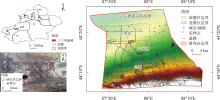
Fig. 1
Overview of the study area and distribution of sampling points"

Tab. 1
Data and sources"
| 数据名称 | 数据精度 | 数据格式 | 简介及来源 |
|---|---|---|---|
| 气象数据 | 1 km | TIFF | 气象数据包括气温和降水数据,采用的1901—2022年中国1 km逐月平均气温和降水量数据集,数据来源于国家科技基础条件平台—国家地球系统科学数据中心( |
| 高程数据 | 30 m | TIFF | 高程数据包括高程、坡向、坡度,数据来源于美国NASA和NGA的航天飞机雷达地形测绘项目(Shuttle Radar Topography Mission,SRTM)的成果产品,下载地址为 |
| 土壤湿度数据 | 1 km | TIFF | 土壤湿度数据采用2000—2020年中国1 km土壤湿度日尺度数据集,数据来源于“国家青藏高原科学数据中心”( |
| NDVI数据 | 30 m | TIFF | NDVI数据基于Google Earth Engine(GEE)平台,选择可用的Landsat 8数据的波段4(红光波段,R)和波段5(近红外波段,NIR)计算NDVI,其中NDVI=(NIR-R)/(NIR+R) |
| 矿化度数据 | 30 m | TIFF | 地下水矿化度数据采用研究区历史数据 |
| pH数据 | 30 m | TIFF | pH数据采用研究区实测数据 |
Tab. 2
Descriptive statistics of soil salinity in the Sangong River Basin"
| 盐渍化等级 | 含盐量/(g·kg-1) | 数量占比/% | 均值/(g·kg-1) | 最小值/(g·kg-1) | 最大值/(g·kg-1) | 变异系数/% |
|---|---|---|---|---|---|---|
| 非盐渍化 | <3 | 68 | 1.02 | 0.29 | 2.86 | 66.81 |
| 轻度盐渍化 | 3~6 | 10 | 4.36 | 3.01 | 5.95 | 28.67 |
| 中度盐渍化 | 6~9 | 7 | 7.67 | 6.27 | 8.74 | 13.82 |
| 重度盐渍化 | 9~12 | 7 | 10.57 | 9.25 | 11.61 | 8.50 |
| 盐土化 | >12 | 8 | 20.79 | 13.40 | 30.18 | 27.86 |
| 总体样本 | 100 | 4.06 | 0.29 | 30.18 | 149.73 | |
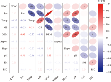
Fig. 2
Correlation of soil salinity with different characterization factors"
Tab. 3
Statistical of soil salinity inversion models based on different methods"
| 模型 | 指标 | 最小值 /(g·kg-1) | 最大值 /(g·kg-1) | 均值 /(g·kg-1) | 标准差 /(g·kg-1) |
|---|---|---|---|---|---|
| RF | R2 | 0.66 | 0.87 | 0.73 | 0.05 |
| RMSE | 1.02 | 4.20 | 1.89 | 0.44 | |
| MAE | 0.86 | 3.11 | 1.49 | 0.33 | |
| SVM | R2 | 0.61 | 0.79 | 0.66 | 0.04 |
| RMSE | 1.35 | 1.92 | 1.73 | 0.15 | |
| MAE | 1.31 | 1.76 | 1.57 | 0.12 | |
| DT | R2 | 0.67 | 0.74 | 0.70 | 0.02 |
| RMSE | 0.56 | 2.33 | 1.66 | 0.42 | |
| MAE | 0.73 | 2.16 | 1.53 | 0.32 | |
| OK | R2 | 0.23 | 0.32 | 0.28 | 0.03 |
| RMSE | 3.74 | 5.23 | 4.46 | 0.41 | |
| MAE | 2.81 | 3.69 | 3.27 | 0.25 |
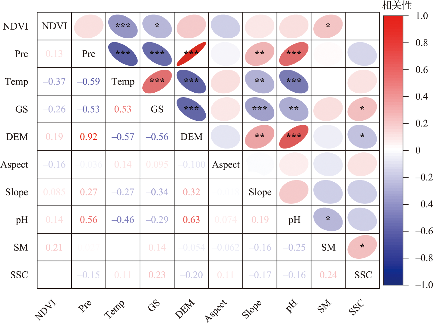
Fig. 3
Correlation between predicted and measured values of different models"

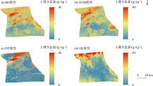
Fig. 4
Spatial distribution of soil salinity predicted by different models"

Tab. 4
Statistical of soil salinity prediction by different models"
| 模型 | 最小值 /(g·kg-1) | 均值 /(g·kg-1) | 最大值 /(g·kg-1) | 标准差 /(g·kg-1) |
|---|---|---|---|---|
| RF | 0.50 | 4.80 | 22.41 | 2.37 |
| SVM | 0.50 | 4.03 | 21.00 | 2.22 |
| DT | 0.29 | 3.91 | 30.18 | 5.26 |
| OK | 0.46 | 4.71 | 36.22 | 3.96 |
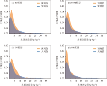
Fig. 5
Plot of soil salinity density between predicted and measured values in different models"

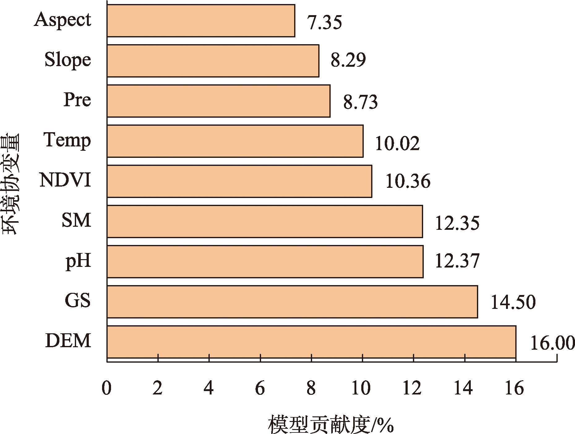
Fig. 6
Contribution rates of different environmental covariates to the RF mode"
| [1] | Ivushkin K, Bartholomeus H, Bregt A K, et al. Global mapping of soil salinity change[J]. Remote Sensing of Environment, 2019, 231(51): 111260. |
| [2] | Zhang H R, Fu X, Zhang Y N, et al. Mapping multi-depth soil salinity using remote sensing-enabled machine learning in the yellow river delta, China[J]. Remote Sensing, 2023, 15(24): 5640. |
| [3] | 杨真, 王宝山. 中国盐渍土资源现状及改良利用对策[J]. 山东农业科学, 2015, 47(4): 125-130. |
| [Yang Zhen, Wang Baoshan. Present status of saline soil resources and countermeasures for improvement and utilization in China[J]. Shandong Agricultural Sciences, 2015, 47(4): 125-130.] | |
| [4] |
Hassani A, Azapagic A, Shokri N. Predicting long-term dynamics of soil salinity and sodicity on a global scale[J]. Proceedings of the National Academy of Sciences of the United States of America, 2020, 117(52): 33017-33027.
doi: 10.1073/pnas.2013771117 pmid: 33318212 |
| [5] | Li J, Zhang T T, Shao Y, et al. Comparing machine learning algorithms for soil salinity mapping using topographic factors and Sentinel-1/2 data: A case study in the yellow river delta of China[J]. Remote Sensing, 2023, 15(9): 2332. |
| [6] | Wang Y G, Li Y. Land exploitation resulting in soil salinization in a desert-oasis ecotone[J]. Catena, 2013, 100: 50-56. |
| [7] | Wang J Z, Ding J L, Yu D L, et al. Capability of Sentinel-2 MSI data for monitoring and mapping of soil salinity in dry and wet seasons in the Ebinur Lake Region, Xinjiang, China[J]. Geoderma, 2019, 353(53): 172-187. |
| [8] | 彭杰, 王家强, 向红英, 等. 土壤含盐量与电导率的高光谱反演精度对比研究[J]. 光谱学与光谱分析, 2014, 34(2): 510-514. |
|
[Peng Jie, Wang Jiaqiang, Xiang Hongying, et al. Comparative study on hyperspectral inversion accuracy of soil salt content and electrical conductivity[J]. Spectroscopy and Spectral Analysis, 2014, 34(2): 510-514.]
pmid: 24822430 |
|
| [9] | Harti A E, Lhissou R, Chokmani K, et al. Spatiotemporal monitoring of soil salinization in irrigated Tadla Plain (Morocco) using satellite spectral indices[J]. International Journal of Applied Earth Observation and Geoinformation, 2016, 50(18): 64-73. |
| [10] | 李建国, 濮励杰, 朱明, 等. 土壤盐渍化研究现状及未来研究热点[J]. 地理学报, 2012, 67(9): 1233-1245. |
|
[Li Jianguo, Pu Lijie, Zhu Ming, et al. The present situation and hot issues in the salt-affected soil research[J]. Acta Geographica Sinica, 2012, 67(9): 1233-1245.
doi: 10.11821/xb201209008 |
|
| [11] | Wang Y G, Deng C Y, Liu Y, et al. Identifying change in spatial accumulation of soil salinity in an inland river watershed, China[J]. Science of The Total Environment, 2018, 621(47): 177-185. |
| [12] | Li H Y, Shi Z, Webster R, et al. Mapping the three-dimensional variation of soil salinity in a rice-paddy soil[J]. Geoderma, 2013, 195(47): 31-41. |
| [13] | Wang J Q, Peng J, Li H Y, et al. Soil salinity mapping using machine learning algorithms with the Sentinel-2 MSI in arid areas, China[J]. Remote Sensing, 2021, 13(2): 305. |
| [14] | Vermeulen D, Niekerk A V. Machine learning performance for predicting soil salinity using different combinations of geomorphometric covariates[J]. Geoderma, 2017, 299(51): 1-12. |
| [15] | Mohamed S A, Metwaly M M, Metwalli M R, et al. Integrating active and passive remote sensing data for mapping soil salinity using machine learning and feature selection approaches in arid regions[J]. Remote Sensing, 2023, 15(7): 1751. |
| [16] | Farifteh J, Meer F V D, Atzberger C, et al. Quantitative analysis of salt-affected soil reflectance spectra: A comparison of two adaptive methods (PLSR and ANN)[J]. Remote Sensing of Environment, 2007, 110(1): 59-78. |
| [17] | Golestani M, Ghahfarokhi Z M, Esfandiarpour-Boroujeni I, et al. Evaluating the spatiotemporal variations of soil salinity in Sirjan Playa, Iran using Sentinel-2A and Landsat-8 OLI imagery[J]. Catena, 2023, 231(51): 107375. |
| [18] | 李小雨, 贾科利, 魏慧敏, 等. 基于随机森林算法的土壤含盐量预测[J]. 干旱区研究, 2023, 40(8): 1258-1267. |
| [Li Xiaoyu, Jia Keli, Wei Huimin, et al. Prediction of soil salt content based on the random forest algorithm[J]. Arid Zone Research, 2023, 40(8): 1258-1267.] | |
| [19] | 蒙莉娜, 丁建丽, 王敬哲, 等. 基于环境变量的渭干河-库车河绿洲土壤盐分空间分布[J]. 农业工程学报, 2020, 36(1): 175-181. |
| [Meng Lina, Ding Jianli, Wang Jingzhe, et al. Spatial distribution of soil salinity in Ugan-Kuqa River delta oasis based on environmental variables[J]. Transactions of the Chinese Society of Agricultural Engineering, 2020, 36(1): 175-181.] | |
| [20] | 杨清, 范晓梅, 王林林, 等. 基于贝叶斯最大熵的黄河三角洲土壤含盐量空间分布预测[J]. 土壤, 2024, 56(2): 406-414. |
| [Yang Qing, Fan Xiaomei, Wang Linlin, et al. Prediction of spatial distribution of soil salinity content in Yellow River Delta based on Bayesian Maximum Entropy Model[J]. Soils, 2024, 56(2): 406-414.] | |
| [21] | 鲁如坤. 土壤农业化学分析方法[M]. 北京: 中国农业科技出版社, 2000. |
| [Lu Rukun, The Analysis Method of Soil Agricultural Chemistry[M]. Beijing: China Agricultural Science and Technology Press, 2000.] | |
| [22] | 陈炳铭, 冯文婷, 王玉刚, 等. 脱硫石膏在碱土改良中的无机固碳作用[J]. 土壤学报, 2024, 61(1): 247-257. |
| [Chen Bingming, Feng Wenting, Wang Yugang, et al. Inorganic carbon sequestration effect of desulfurized gypsum in alkaline soil improvement[J]. Acta Pedologica Sinica, 2024, 61(1): 247-257.] | |
| [23] | Sarkar S K, Rudra R R, Sohan A R, et al. Coupling of machine learning and remote sensing for soil salinity mapping in coastal area of Bangladesh[J]. Scientific Reports, 2023, 13(1): 17056. |
| [24] | 朱婉怡, 张振克, 郭新亚, 等. 马拉河流域植被生态需水特征及估算[J]. 生态学报, 2023, 43(18): 7523-7535. |
| [Zhu Wanyi, Zhang Zhenke, Guo Xinya, et al. Characteristics and estimation of vegetation ecological water demand in the Mara River Basin[J]. Acta Ecologica Sinica, 2023, 43(18): 7523-7535.] | |
| [25] | 马国林, 丁建丽, 韩礼敬, 等. 基于变量优选与机器学习的干旱区湿地土壤盐渍化数字制图[J]. 农业工程学报, 2020, 36(19): 124-131. |
| [Ma Guolin, Ding Jianli, Han Lijing, et al. Digital mapping of soil salinization in arid area wetland based on variable optimized selection and machine learning[J]. Transactions of the Chinese Society of Agricultural Engineering, 2020, 36(19): 124-131.] | |
| [26] | Huang Y, Zhao L. Review on landslide susceptibility mapping using support vector machines[J]. Catena, 2018, 165(46): 520-529. |
| [27] | 王海江, 蒋天池, Yunger J A, 等. 基于支持向量机的土壤主要盐分离子高光谱反演模型[J]. 农业机械学报, 2018, 49(5): 263-270. |
| [Wang Haijiang, Jiang Tianchi, Yonger J A, et al. Hyperspectral inverse model for soil salt ions based on support vector machine[J]. Transactions of the Chinese Society for Agricultural Machinery, 2018, 49(5): 263-270.] | |
| [28] | Haq Y U, Shahbaz M, Asif H M S, et al. Spatial mapping of soil salinity Using Machine Learning and Remote Sensing in Kot Addu, Pakistan[J]. Sustainability, 2023, 15(17): 12943. |
| [29] | Bouquet A, Laabir M, Rolland J l, et al. Prediction of Alexandrium and Dinophysis algal blooms and shellfish contamination in French Mediterranean Lagoons using decision trees and linear regression: A result of 10 years of sanitary monitoring[J]. Harmful Algae, 2022, 115(21): 102234. |
| [30] | 韩文霆, 崔家伟, 崔欣, 等. 基于特征优选与机器学习的农田土壤含盐量估算研究[J]. 农业机械学报, 2023, 54(3): 328-337. |
| [Han Wenting, Cui Jiawei, Cui Xin, et al. Estimation of farmland soil salinity content based on feature optimization and machine learning algorithms[J]. Transactions of the Chinese Society for Agricultural Machinery, 2023, 54(3): 328-337.] | |
| [31] | 陈琳, 任春颖, 王宗明, 等. 基于克里金插值的耕地表层土壤有机质空间预测[J]. 干旱区研究, 2017, 34(4): 798-805. |
| [Chen Lin, Ren Chunying, Wang Zongming, et al. Prediction of spatial distribution of topsoil organic matter content in cultivated land using Kriging methods[J]. Arid Zone Research, 2017, 34(4): 798-805.] | |
| [32] | 刘新, 郝媛媛, 花立民. 石羊河下游民勤盆地土壤盐分空间分异特征[J]. 干旱区研究, 2023, 40(10): 1615-1624. |
| [Liu Xin, Hao Yuanyuan, Hua Limin. Spatial differentiation characteristics of soil salinity in Minqin Basin, downstream of Shiyang River, China[J]. Arid Zone Research, 2023, 40(10): 1615-1624.] | |
| [33] | 王瑾杰, 丁建丽, 张子鹏, 等. 基于多模型对比的土壤盐分制图及不确定性研究[J]. 新疆大学学报(自然科学版), 2022, 39(5): 513-521, 529. |
| [Wang Jinjie, Ding Jianli, Zhang Zipeng, et al. Study on soil salinity mapping and uncertainty based on multi model comparison[J]. Journal of Xinjiang University (Natural Science Edition in Chinese and English), 2022, 39(5): 513-521, 529.] | |
| [34] | 王飞, 杨胜天, 丁建丽, 等. 环境敏感变量优选及机器学习算法预测绿洲土壤盐分[J]. 农业工程学报, 2018, 34(22): 102-110. |
| [Wang Fei, Yang Shengtian, Ding Jianli, et al. Environmental sensitive variable optimization and machine learning algorithm using in soil salt prediction at oasis[J]. Transactions of the Chinese Society of Agricultural Engineering, 2018, 34(22): 102-110.] | |
| [35] | 段梦琦, 张晓光, 王豹. 黄河三角洲典型区土壤盐分空间分布预测方法研究[J]. 中国农业资源与区划, 2021, 42(8): 243-250. |
| [Duan Mengqi, Zhang Xiaoguang, Wang Bao. Prediction method of spatial distribution for soil salinity in typical areas of the yellow river delta[J]. Chinese Journal of Agricultural Resources and Regional Planning, 2021, 42(8): 243-250.] | |
| [36] | 颜安, 蒋平安, 盛建东, 等. 玛纳斯河流域表层土壤盐分空间变异特征研究[J]. 土壤学报, 2014, 51(2): 410-414. |
| [Yan An, Jiang Ping’an, Sheng Jiandong, et al. Spatial variability of surface soil salinity in Manas River Basin[J]. Acta Pedologica Sinica, 2014, 51(2): 410-414.] | |
| [37] | Ge X Y, Ding J L, Teng D X, et al. Updated soil salinity with fine spatial resolution and high accuracy: The synergy of Sentinel-2 MSI, environmental covariates and hybrid machine learning approaches[J]. Catena, 2022, 212(50): 106054. |
| [38] |
卫雨西, 陈丽娟, 席海洋, 等. 石羊河流域土壤水分和电导率的空间分布特征[J]. 中国沙漠, 2023, 43(3): 264-273.
doi: 10.7522/j.issn.1000-694X.2023.00038 |
|
[Wei Yuxi, Chen Lijuan, Xi Haiyang, et al. Spatial differentiation of soil moisture and conductivity in Shiyang River Basin[J]. Journal of Desert Research, 2023, 43(3): 264-273.]
doi: 10.7522/j.issn.1000-694X.2023.00038 |
|
| [39] | 徐英, 葛洲, 王娟, 等. 基于指示Kriging法的土壤盐渍化与地下水埋深关系研究[J]. 农业工程学报, 2019, 35(1): 123-130. |
| [Xu Ying, Ge Zhou, Wang Juan, et al. Study on relationship between soil salinization and groundwater table depth based on indicator Kriging[J]. Transactions of the Chinese Society of Agricultural Engineering, 2019, 35(1): 123-130.] | |
| [40] | 陈永宝, 胡顺军, 罗毅, 等. 新疆喀什地下水浅埋区弃荒地表层土壤积盐与地下水的关系[J]. 土壤学报, 2014, 51(1): 75-81. |
| [Chen Yongbao, Hu Shunjun, Luo Yi, et al. Relationship between salt accumulation in topsoil of deserted land and groundwater in areas with shallow groundwater table in Kashi, Xinjiang[J]. Acta Pedologica Sinica, 2014, 51(1): 75-81.] | |
| [41] | 麦麦提吐尔逊·艾则孜, 米热古力·艾尼瓦尔, 古丽孜巴·艾尼瓦尔, 等. 伊犁绿洲土壤盐渍化与浅层地下水水化学特征分析[J]. 干旱地区农业研究, 2015, 33(5): 193-200, 257. |
| [Mamattursun Eziz, Mihrigul Anwar, Gulziba Anwar, et al. Analysis on soil salinization and hydrochemical characteristics of shallow ground water in Ili Oasis[J]. Agricultural Research in the Arid Areas, 2015, 33(5): 193-200, 257.] | |
| [42] | 高婷婷, 丁建丽, 哈学萍, 等. 基于流域尺度的土壤盐分空间变异特征——以渭干河-库车河流域三角洲绿洲为例[J]. 生态学报, 2010, 30(10): 2695-2705. |
| [Gao Tingting, Ding Jianli, Ha Xueping, et al. The spatial variability of salt content based on river basin scale: A case study of the delta oasis in Weigan-Kuqa Watershed[J]. Acta Ecologica Sinica, 2010, 30(10): 2695-2705.] |
|
||