Arid Zone Research ›› 2021, Vol. 38 ›› Issue (3): 589-599.doi: 10.13866/j.azr.2021.03.01
• Water Resources and Ulilization • Next Articles
GUO Jing1,2,3( ),WANG Guangyan4,XU Shengwu4,ZHANG Guangpeng1,2,3,YUAN Kaiye1,2,3,LING Hongbo1,2(),Xiayidan Wumaierjiang5
Received:2020-05-08
Revised:2020-07-03
Online:2021-05-15
Published:2021-06-17
Contact:
Hongbo LING
E-mail:guojing18@mails.ucas.edu.cn;linghongbo0929@163.com
GUO Jing,WANG Guangyan,XU Shengwu,ZHANG Guangpeng,YUAN Kaiye,LING Hongbo,Xiayidan Wumaierjiang. Dynamic assessment of Tarim River carbon storage under enhanced water resources management[J].Arid Zone Research, 2021, 38(3): 589-599.
Add to citation manager EndNote|Reference Manager|ProCite|BibTeX|RefWorks
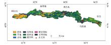
Fig. 1
Maps showing land use/cover in the mainstream area of the Tarim River"

Tab. 1
Caron density of different land use types in the mainstream area of the Tarim River"
| 土地利用类型 | 碳密度/(t·hm-2) | 来源文献 | ||||||||
|---|---|---|---|---|---|---|---|---|---|---|
| 地上 | 地下 | 死亡有机物 | ||||||||
| 2000年 | 2010年 | 2018年 | 2000年 | 2010年 | 2018年 | 2000年 | 2010年 | 2018年 | ||
| 有林地 | 0.22 | 0.34 | 0.31 | 0.08 | 0.12 | 0.11 | 0.09 | 0.14 | 0.13 | [ |
| 疏林地 | 0.18 | 0.31 | 0.27 | 0.06 | 0.10 | 0.09 | 0.07 | 0.12 | 0.10 | [ |
| 灌木林 | 0.19 | 0.32 | 0.28 | 0.07 | 0.12 | 0.10 | 0.05 | 0.08 | 0.07 | [ |
| 草地 | 0.17 | 0.24 | 0.28 | 1.05 | 1.48 | 1.72 | 0.23 | 0.31 | 0.36 | [ |
| 耕地 | 0.48 | 0.60 | 0.63 | 0 | 0 | 0 | 0 | 0 | 0 | [ |
| 水域 | 0 | 0 | 0 | 0 | 0 | 0 | 0 | 0 | 0 | [ |
| 建设用地 | 0 | 0 | 0 | 0 | 0 | 0 | 0 | 0 | 0 | [ |
| 未利用地 | 0 | 0 | 0 | 0 | 0 | 0 | 0 | 0 | 0 | [ |
Tab. 2
Land use area and proportion in the mainstream area of the Tarim River during 2000-2018"
| 土地利用类型 | 2000年 | 2010年 | 2018年 | |||||
|---|---|---|---|---|---|---|---|---|
| 面积 /104 hm2 | 比例 /% | 面积 /104 hm2 | 比例 /% | 面积 /104 hm2 | 比例 /% | |||
| 耕地 | 17.93 | 12.94 | 25.96 | 18.74 | 29.59 | 21.36 | ||
| 林地 | 48.21 | 34.79 | 45.43 | 32.79 | 43.15 | 31.14 | ||
| 草地 | 43.75 | 31.57 | 37.38 | 26.98 | 34.66 | 25.01 | ||
| 水域 | 5.29 | 3.82 | 5.66 | 4.09 | 7.11 | 5.14 | ||
| 建设用地 | 0.44 | 0.31 | 0.60 | 0.43 | 0.87 | 0.63 | ||
| 未利用地 | 22.94 | 16.55 | 23.53 | 16.98 | 23.17 | 16.72 | ||
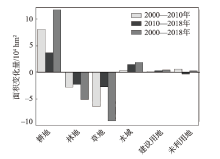
Fig. 2
Change of land use in the mainstream area of the Tarim River during 2000-2008"
Tab. 3
Transition matrix of land use in the mainstream area of the Tarim River during 2000-2018/hm2"
| 时段 | 土地利用类型 | 耕地 | 林地 | 草地 | 水域 | 建设用地 | 未利用地 |
|---|---|---|---|---|---|---|---|
| 2000—2010年 | 耕地 | 176896.61 | 177.60 | 383.39 | 48.73 | 766.23 | 1719.71 |
| 林地 | 27648.10 | 449204.76 | 2058.00 | 667.94 | 154.98 | 2464.06 | |
| 草地 | 54605.15 | 3316.68 | 368312.73 | 7598.88 | 597.20 | 3475.37 | |
| 水域 | 1339.27 | 1311.52 | 2278.57 | 48370.14 | 0.00 | 79.32 | |
| 建设用地 | 7.52 | 0.00 | 0.00 | 0.00 | 4300.22 | 64.12 | |
| 未利用地 | 649.42 | 305.54 | 767.32 | 0.00 | 167.28 | 227538.47 | |
| 2010—2018年 | 耕地 | 236148.40 | 8436.27 | 10940.27 | 1674.75 | 2659.61 | 396.42 |
| 林地 | 32228.98 | 390551.31 | 16857.65 | 9479.26 | 98.81 | 5177.07 | |
| 草地 | 21869.35 | 21526.50 | 312625.53 | 7388.01 | 285.49 | 10240.00 | |
| 水域 | 635.14 | 2276.26 | 2314.57 | 51460.21 | 0.00 | 0.01 | |
| 建设用地 | 54.55 | 0.00 | 181.14 | 208.42 | 5367.00 | 167.28 | |
| 未利用地 | 5649.12 | 8854.76 | 3787.17 | 976.56 | 318.39 | 215738.47 |

Fig. 3
Changes of carbon storage/caron density under different land use types in the mainstream area of the Tarim River during 2000-2018"
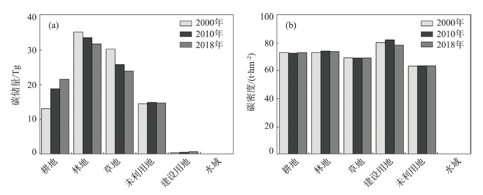
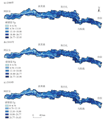
Fig. 4
Spatial distribution of carbon storage in the mainstream area of the Tarim River during 2000-2018"

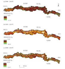
Fig. 5
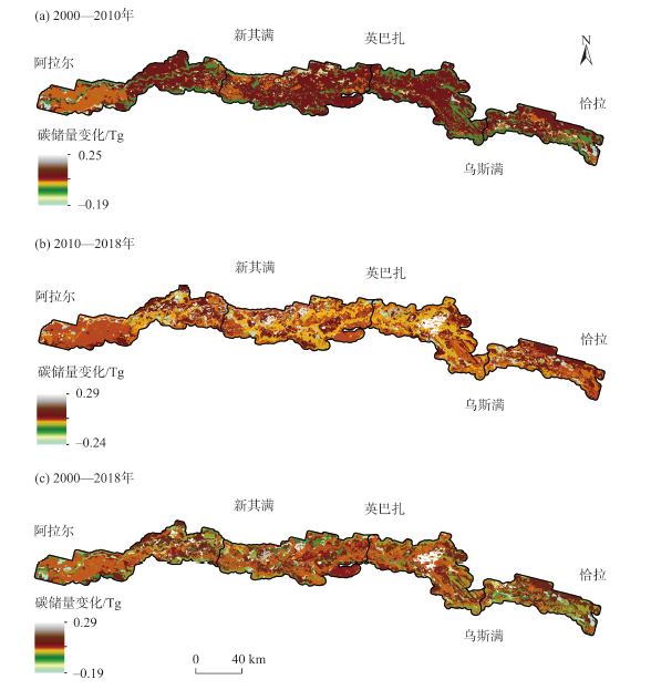
Spatial distribution of carbon storage change in the mainstream area of the Tarim River during 2000-2018"
| [1] | He Chunyang, Zhang Da, Huang Qingxu, et al. Assessing the potential impacts of urban expansion on regional carbon storage by linking the LUSD-urban and InVEST models[J]. Environmental Modelling & Software, 2016,75:44-58. |
| [2] | 王渊刚, 罗格平, 赵树斌, 等. 新疆耕地变化对区域碳平衡的影响[J]. 地理学报, 2014,69(1):110-120. |
| [ Wang Yuangang, Luo Geping, Zhao Shubin, et al. Effects of arable land change on regional carbon balance in Xinjiang[J]. Acta Geographica Sinica, 2014,69(1):110-120. ] | |
| [3] |
Sterling S M, Ducharne Agnès, Polcher J. The impact of global land-cover change on the terrestrial water cycle[J]. Nature Climate Change, 2012,3(4):385-390.
doi: 10.1038/nclimate1690 |
| [4] |
Vitousek P M, Mooney H A, Lubchenco J, et al. Human domination of earth's ecosystems[J]. Science, 1997,277(5325):494-499.
doi: 10.1126/science.277.5325.494 |
| [5] | 高扬, 何念鹏, 汪亚峰. 生态系统固碳特征及其研究进展[J]. 自然资源学报, 2013,28(7):1264-1274. |
| [ Gao Yang, He Nianpeng, Wang Yafeng. Characteristics of carbon sequestration by ecosystem and progress in its research[J]. Journal of Natural Resources, 2013,28(7):1264-1274. ] | |
| [6] | 张云倩, 张晓祥, 陈振杰, 等. 基于InVEST模型的江苏海岸带生态系统碳储量时空变化研究[J]. 水土保持研究, 2016,23(3):100-105. |
| [ Zhang Yunqian, Zhang Xiaoxiang, Chen Zhenjie, et al. Research on the spatiotemporal variation of carbon storage in coastal zone ecosystem of Jiangsu based on InVEST Model[J]. Research of Soil and Water Conservation, 2016,23(3):100-105. ] | |
| [7] |
Andreetta A, Huertas A D, Lotti M, et al. Land use changes affecting soil organic carbon storage along a mangrove swamp rice chronosequence in the Cacheu and Oio regions (northern Guinea-Bissau)[J]. Agriculture, Ecosystems and Environment, 2016,216:314-321.
doi: 10.1016/j.agee.2015.10.017 |
| [8] |
Gelaw A M, Singh B R, Lal R. Soil organic carbon and total nitrogen stocks under different land uses in a semi-arid watershed in Tigray, Northern Ethiopia[J]. Agriculture, Ecosystems and Environment, 2014,188:256-263.
doi: 10.1016/j.agee.2014.02.035 |
| [9] | 方精云, 郭兆迪, 朴世龙, 等. 1981—2000年中国陆地植被碳汇的估算[J]. 中国科学(D辑: 地球科学), 2007,37(6):804-812. |
| [ Fang Jingyun, Guo Zhaodi, Piao Shilong, et al. Assessment of China terrestrial vegetation carbon sinks in 1981-2000[J]. Science in China(Series D), 2007,37(6):804-812. ] | |
| [10] | 方精云, 刘国华, 徐嵩龄. 我国森林植被的生物量和净生产量[J]. 生态学报, 1996,16(5):497-508. |
| [ Fang Jingyun, Liu Guohua, Xu Songling. Biomass and net production of porest vegetation in China[J]. Acta Ecologica Sinica, 1996,16(5):497-508. ] | |
| [11] | 朴世龙, 方精云, 贺金生, 等. 中国草地植被生物量及其空间分布格局[J]. 植物生态学报, 2004,28(4):491-498. |
| [ Piao Shilong, Fang Jingyun, He Jinjie, et al. Spatial distribution of grassland biomass in China[J]. Acta Phytoecologica Sinica, 2004,28(4):491-498. ] | |
| [12] | 王淑君, 管东生, 黎夏, 等. 广州森林碳储量时空演变及异质性分析[J]. 环境科学学报, 2008,28(4):778-785. |
| [ Wang Shujun, Guan Dongsheng, Li Xia, et al. The spatial-temporal evolution and heterogeneity analysis of forest carbon storage in Guangzhou, China[J]. Acta Scientiae Circumstantiae, 2008,28(4):778-785. ] | |
| [13] | 杨玉海, 陈亚宁, 李卫红, 等. 塔里木河干流土地利用/覆被变化对土壤有机碳储量的影响[J]. 中国环境科学, 2016,36(9):2784-2790. |
| [ Yang Yuhai, Chen Yaning, Li Weihong, et al. Effects of land use/cover change on soil organic carbon storage in the main stream of Tarim River[J]. China Environmental Science, 2016,36(9):2784-2790. ] | |
| [14] | 尚二萍, 张红旗. 1980s—2010s新疆伊犁河谷草地碳存储动态评估[J]. 资源科学, 2016,38(7):1229-1238. |
| [ Shang Erping, Zhang Hongqi. Dynamic assessment of the carbon stock of different grassland types in the Yili Valley from 1980s to2010s[J]. Resources Science, 2016,38(7):1229-1238. ] | |
| [15] | Bae J, Ryu Y. Land use and land cover changes explain spatial and temporal variations of the soil organic carbon stocks in a constructed urban park[J]. Landscape & Urban Planning, 2015,136(136):57-67. |
| [16] | 邓铭江, 周海鹰, 徐海量, 等. 塔里木河干流上中游丰枯情景下生态水调控研究[J]. 干旱区研究, 2017,34(5):959-966. |
| [ Deng Mingjiang, Zhou Haiying, Xu Hailiang, et al. Regulation of ecological water volume under high-or low-flow in the mainstream area of the Tarim River[J]. Arid Zone Research, 2017,34(5):959-966. ] | |
| [17] | 黄运梅, 徐海量, 张广朋, 等. 基于年轮信息的单株胡杨(Populus euphratica)树干年新增生物量估算方法[J]. 干旱区研究, 2018,35(4):905-911. |
| [ Huang Yunmei, Xu Hailiang, Zhang Guangpeng, et al. Estimation of annual biomass of individual Populus euphratica based on tree-ring data[J]. Arid Zone Research, 2018,35(4):905-911. ] | |
| [18] | 陈亚宁, 崔旺诚, 李卫红, 等. 塔里木河的水资源利用与生态保护[J]. 地理学报, 2003,58(2):215-222. |
| [ Chen Yaning, Cui Wang-cheng, Li Weihong, et al. The influence of groundwater on vegetation in the lower reaches of Tarim River, China[J]. Acta Geographica Sinica, 2003,58(2):215-222. ] | |
| [19] | 徐海量, 陈亚宁, 杨戈. 塔里木河下游生态输水对植被和地下水位的影响[J]. 环境科学, 2003,24(4):18-22. |
| [ Xu Hailiang, Chen Yaning, Yang Ge. Effect of translating water on vegetation at the lower reaches of Tarim River[J]. Chinese Journal of Environmental Science, 2003,24(4):18-22. ] | |
| [20] | 徐海量, 陈亚宁, 李卫红. 塔里木河下游生态输水后地下水的响应研究[J]. 环境科学研究, 2003,16(2):19-22, 38. |
| [ Xu Hailiang, Chen Yaning, Li Weihong. Study on response of groundwater after ecological water transport at the lower reaches of the Tarim River[J]. Research of Environmental Sciences, 2003,16(2):19-22, 38. ] | |
| [21] | 熊宇斐, 张广朋, 陈超群, 等. 基于水量变化的塔里木河统一管理成效评价[J]. 自然资源学报, 2016,31(11):1806-1816. |
| [ Xiong Yufei, Zhang Guangpeng, Chen Chaoqun, et al. Effectiveness evaluation of the unified management based on water change in Tarim River Basin[J]. Journal of Natural Resources, 2016,31(11):1806-1816. ] | |
| [22] |
Chen Yaning, Takeuchi K, Xu Changchun, et al. Regional climate change and its effects on river runoff in the Tarim Basin, China[J]. Hydrological Processes, 2006,20(10):2207-2216.
doi: 10.1002/(ISSN)1099-1085 |
| [23] | 徐海量, 叶茂, 宋郁东, 等. 塔里木河流域水资源变化的特点与趋势[J]. 地理学报, 2005,60(3):487-494. |
| [ Xu Hailiang, Ye Mao, Song Yudong, et al. The dynamic variation of water resources and its tendency in Tarim River Basin[J]. Acta Geographica Sinica, 2005,60(3):487-494. ] | |
| [24] | 叶茂, 徐海量, 宋郁东, 等. 塔里木河流域水资源利用面临的主要问题[J]. 干旱区研究, 2006,23(3):388-392. |
| [ Ye Mao, Xu Hailiang, Song Yudong, et al. Some problems and challenges about water resources utilization in the Tarim River Basin[J]. Arid Zone Research, 2006,23(3):388-392. ] | |
| [25] | 张广朋, 徐海量, 杜清, 等. 塔里木河流域降水量的非线性时空变化对比研究及预测[J]. 水资源与水工程学报, 2015,26(2):58-63. |
| [ Zhang Guangpeng, Xu Hailiang, Du Qing, et al. Comparative study and prediction of nonlinear temporal and spatial variation of precipitation in Tarim River Basin[J]. Journal of Water Resources and Water Engineering, 2015,26(2):58-63. ] | |
| [26] | 白元, 徐海量, 凌红波, 等. 塔里木河干流区天然植被的空间分布及生态需水[J]. 中国沙漠, 2014,34(5):1410-1416. |
| [ Bai Yuan, Xu Hailiang, Ling Hongbo, et al. Spatial distribution characteristics and ecological water requirement of natural vegetation along the mainstream of the Tarim River[J]. Journal of Desert Research, 2014,34(5):1410-1416. ] | |
| [27] | Tallis H T, Ricketts T, Guerry A D, et al. In VEST 2.6.0 user’s guide. Stanford CA: The Natural Capital Project, 2013,24-29:233-250. |
| [28] | 郑拴丽, 许文强, 杨辽, 等. 新疆阿尔泰山森林生态系统碳密度与碳储量估算[J]. 自然资源学报, 2016,31(9):1553-1563. |
| [ Zheng Shuanli, Xu Wenqiang, Yang Liao, et al. Carbon density and storage of forest ecosystem in Altay Mountains, Xinjiang[J]. Journal of Natural Resources, 2016,31(9):1553-1563. ] | |
| [29] | 徐自为, 张智杰. 基于土地利用变更调查的2010—2016年新疆尉犁县生态系统碳储量时空变化[J]. 环境科学研究, 2018,31(11):1909-1917. |
| [ Xu Ziwei, Zhang Zhijie. Spatiotemporal variation of carbon storage in Yuli County during 2010-2016[J]. Research of Environmental Sciences, 2018,31(11):1909-1917. ] | |
| [30] | 包玉斌. 基于InVEST模型的陕北黄土高原生态服务功能时空变化研究[D]. 西安: 西北大学, 2015. |
| [ Bao Yubin. Temporal and Spatial Change of Ecological Services on Loess Plateau of Shaanxi by InVEST model[D]. Xi’an: Northwest University, 2015. ] | |
| [31] | 方精云, 杨元合, 马文红, 等. 中国草地生态系统碳库及其变化[J]. 中国科学(生命科学), 2010,40(7):566-576. |
| [ Fang Jingyun, Yang Yuanhe, Ma Wenhong, et al. Ecosystem carbon stocks and their changes in China’s grasslands[J]. Scientia Sinica Vitae(Life Sciences), 2010,40(7):566-576. ] | |
| [32] | 于东升, 史学正, 孙维侠, 等. 基于1∶100万土壤数据库的中国土壤有机碳密度及储量研究[J]. 应用生态学报, 2005,16(12):2279-2283. |
| [ Yu Dongsheng, Shi Xuezheng, Sun Weixia, et al. Estimation of China soil organic carbon storage and density based on 1: 1000000 soil database[J]. Chinese Journal of Applied Ecology, 2005,16(12):2279-2283. ] | |
| [33] | 李真. 干旱内陆河流域生态系统服务空间权衡与协同研究[D]. 兰州: 西北师范大学, 2017. |
| [ Li Zhen. The Dynamic Analysis on Trade-off s and Synergies of Ecosystem Services in the Arid Inland River Basin[D]. Lanzhou: Northwest Normal University, 2017. ] | |
| [34] | 张影, 谢余初, 齐姗姗, 等. 基于InVEST模型的甘肃白龙江流域生态系统碳储量及空间格局特征[J]. 资源科学, 2016,38(8):1585-1593. |
| [ Zhang Ying, Xie Yuchu, Qi Shanshan, et al. Carbon storage and spatial distribution characteristics on the Bailongjiang watershed in Gansu based on InVEST model[J]. Resources Science, 2016,38(8):1585-1593. ] | |
| [35] | 张斯屿, 白晓永, 王世杰, 等. 基于InVEST模型的典型石漠化地区生态系统服务评估——以晴隆县为例[J]. 地球环境学报, 2014,5(5):328-338. |
| [ Zhang Siyu, Bai Xiaoyong, Wang Shijie, et al. Ecosystem services evaluation of typical rocky desertification areas based on InVEST model: A case study at Qinglong County, Guizhou Province[J]. Journal of Earth Environment, 2014,5(5):328-338. ] | |
| [36] | 李敏. 基于InVEST模型的生态系统服务功能评价研究[D]. 北京: 北京林业大学, 2016. |
| [ Li Min. Ecosystem Services Evaluation Based on InVEST Model: ACase study of Yanqing, Beijing[D]. Beijing: Beijing Forestry University, 2016. ] | |
| [37] | 贾芳芳. 基于InVEST模型的赣江流域生态系统服务功能评估[D]. 北京: 中国地质大学, 2014. |
| [ Jia Fangfang. InVEST Model Based Ecosystem Services Evaluation with case case study on Ganjiang River Basin[D]. Beijing: China University of Geosciences, 2014. ] | |
| [38] | 白元, 徐海量, 凌红波, 等. 塔里木河干流区土地利用与生态系统服务价值的变化[J]. 中国沙漠, 2013,33(6):1912-1920. |
| [ Bai Yuan, Xu Hailiang, Ling Hongbo, et al. Analysis on land use changes and ecosystem services value in the area along the Tarim River[J]. Journal of Desert Research, 2013,33(6):1912-1920. ] | |
| [39] |
戴尔阜, 翟瑞雪, 葛全胜, 等. 1980s—2010s内蒙古草地表层土壤有机碳储量及其变化[J]. 地理学报, 2014,69(11):1651-1660.
doi: 10.11821/dlxb201411006 |
|
[ Dai Erfu, Zhai Ruixue, Ge Quansheng, et al. Topsoil organic carbon storage and its changes in Inner Mongolia grassland from the 1980s to 2010s[J]. Acta Geographica Sinica, 2014,69(11):1651-1660. ]
doi: 10.11821/dlxb201411006 |
|
| [40] | 方岳, 刘华, 白志强, 等. 新疆喀纳斯保护区森林碳储量及碳密度研究[J]. 南京林业大学学报(自然科学版), 2014,38(6):17-22. |
| [ Fang Yue, Liu Hua, Bai Zhiqiang, et al. Spatial pattern of carbon storage and carbon density in forest vegetation of the Kanas National Natural Reserve[J]. Journal of Nanjing Forestry University (Natural Sciences Edition), 2014,38(6):17-22. ] | |
| [41] | 赵锐锋, 陈亚宁, 李卫红, 等. 塔里木河干流区土地覆被变化与景观格局分析[J]. 地理学报, 2009,64(1):95-106. |
| [ Zhao Ruifeng, Chen Yaning, Li Weihong, et al. Land cover change and landscape pattern in the mainstream of the Tarim River[J]. Acta Geographica Sinica, 2009,64(1):95-106. ] | |
| [42] | 孙美琴, 赵成义, 施枫芝, 等. 近20 a塔里木河干流区土地利用变化特征[J]. 干旱区研究, 2013,30(1):16-21. |
| [ Sun Meiqin, Zhao Chengyi, Shi Fengzhi, et al. Analysis on land use change in the mainstream area of the Tarim River in recent 20 years[J]. Arid Zone Research, 2013,30(1):16-21. ] |
| [1] | WU Zhaoqiao, LIN Fei, NIU Junjie, GENG Tianwei. Response of ecosystem service to land use pattern change in the Shanxi central urban agglomeration [J]. Arid Zone Research, 2024, 41(7): 1153-1166. |
| [2] | LI Bingjie, FAN Zhitao, QU Zhicheng, YAO Shunyu, SU Xiashu, LIU Dongwei, WANG Lixin. Evaluation and prediction of ecosystem carbon storage in the Inner Mongolia section of the Yellow River Basin based on the InVEST-PLUS model [J]. Arid Zone Research, 2024, 41(7): 1217-1227. |
| [3] | ZHANG Shunxin, WU Zihao, YAN Qingwu, LI Gui’e, MU Shouguo. Spatiotemporal changes in the ecosystem carbon storage on the northern slope of the Tianshan Mountains and simulations based on the PLUS-InVEST model [J]. Arid Zone Research, 2024, 41(7): 1228-1237. |
| [4] | YANG Rongqin, XIAO Yulei, CHI Miaomiao, MU Zhenxia. Temporal and spatial variations of human activities and landscape ecological risks in the Tarim River Basin, China, during the last 20 years [J]. Arid Zone Research, 2024, 41(6): 1010-1020. |
| [5] | GAO Yayu, SONG Yu, ZHAO Tinghong, GAO Jinfang, HE Wenbo, LI Zexia. Spatiotemporal evolution of water yield in the lower Malian River Basin [J]. Arid Zone Research, 2024, 41(5): 776-787. |
| [6] | CHENG Xiaoyu, LYU Jiehua. Mechanism of climate influence on carbon storage in the Tarim River Basin and attribution under topographic differentiation [J]. Arid Zone Research, 2024, 41(5): 865-875. |
| [7] | LIU Rulong, ZHAO Yuanyuan, CHEN Guoqing, CHI Wenfeng, LIU Zhengjia. Assessment of habitat quality in the Yellow River Basin in Inner Mongolia from 1990 to 2020 [J]. Arid Zone Research, 2024, 41(4): 674-683. |
| [8] | LI Jiake, SHAO Zhanlin. Spatiotemporal evolution and prediction of carbon stock in Urumqi City based on PLUS and InVEST models [J]. Arid Zone Research, 2024, 41(3): 499-508. |
| [9] | YAN Li, CAO Guangchao, KANG Ligang, LIU Menglin, YE Deli. Analysis of spatial and temporal changes in habitat quality and driving factors in Gonghe County using the InVEST model [J]. Arid Zone Research, 2024, 41(2): 314-325. |
| [10] | WANG Yang, FENG Zhuoya, XU Li, GAO Wenxin. Response and influencing factors of habitat quality and land use change in the Tarim River Basin [J]. Arid Zone Research, 2024, 41(12): 2132-2142. |
| [11] | ZHANG Yin, SUN Congjian, LIU Geng, CHAO Jinlong, GENG Tianwei. Response of NDSI in the Tarim River Basin mountainous areas to climate change over the past 20 years [J]. Arid Zone Research, 2024, 41(10): 1639-1648. |
| [12] | SHEN Cao,REN Zongping,LI Peng,WANG Kaibo,LU Kexin,REN Zhengyan,WEI Xiaoyan. Identification of priority areas for ecological compensation under soil and water conservation in Ningxia [J]. Arid Zone Research, 2023, 40(9): 1527-1536. |
| [13] | MA Jilong, SHI Junhui, WANG Xinying, Aliya BAIDOURELA, LIU Maoxiu, Aijier ABULA. Effects of flood overflow on soil organic carbon and active components of Populus euphratica forest in the middle reaches of the Tarim River [J]. Arid Zone Research, 2023, 40(8): 1248-1257. |
| [14] | ZHANG Xiaomin, ZHANG Dongmei, ZHANG Wei. Effects of human activities on carbon storage in the Irtysh River Basin [J]. Arid Zone Research, 2023, 40(8): 1333-1345. |
| [15] | BAO Yubin,WANG Yaozong,LU Feng,LIU Zizeng,MA Dawei,YANG Yong,WU Juan,ZHANG Yongkang. Construction of an ecological security pattern and zoning optimization for territorial space in the Liupan Mountain Area [J]. Arid Zone Research, 2023, 40(7): 1172-1183. |
|
||