Arid Zone Research ›› 2024, Vol. 41 ›› Issue (2): 314-325.doi: 10.13866/j.azr.2024.02.14
• Ecology and Environment • Previous Articles Next Articles
YAN Li1,2( ), CAO Guangchao1,2,3(), KANG Ligang1,2, LIU Menglin1,2, YE Deli4
Received:2023-08-10
Revised:2023-11-01
Online:2024-02-15
Published:2024-03-11
YAN Li, CAO Guangchao, KANG Ligang, LIU Menglin, YE Deli. Analysis of spatial and temporal changes in habitat quality and driving factors in Gonghe County using the InVEST model[J].Arid Zone Research, 2024, 41(2): 314-325.
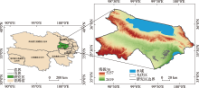
Fig. 1
Geographical location of the study area"

Tab. 1
Threat factors and weights"
| 威胁因子 | 最大影响距离/m | 权重 | 空间衰减方式 |
|---|---|---|---|
| 耕地 | 4 | 0.7 | 线性衰减 |
| 城镇用地 | 8 | 1 | 指数衰减 |
| 农村居民点 | 5 | 0.6 | 指数衰减 |
| 其他建设用地 | 8 | 0.4 | 指数衰减 |
| 未利用地 | 6 | 0.5 | 线性衰减 |
Tab. 2
Habitat suitability and sensitivity to threat factors for each land class"
| 二级地类 | 生境适宜度 | 耕地 | 城镇用地 | 农村居民点 | 其他建设用地 | 未利用地 |
|---|---|---|---|---|---|---|
| 旱地 | 0.5 | 0 | 0.6 | 0.5 | 0.5 | 0.4 |
| 灌木林 | 0.9 | 0.6 | 0.8 | 0.7 | 0.7 | 0.2 |
| 疏林地 | 0.85 | 0.7 | 0.9 | 0.8 | 0.8 | 0.2 |
| 其他林地 | 0.9 | 0.7 | 1 | 0.9 | 0.8 | 0.2 |
| 高覆盖草地 | 0.85 | 0.7 | 0.6 | 0.55 | 0.6 | 0.6 |
| 中覆盖草地 | 0.75 | 0.7 | 0.7 | 0.6 | 0.7 | 0.7 |
| 低覆盖草地 | 0.7 | 0.7 | 0.8 | 0.7 | 0.8 | 0.8 |
| 河渠 | 1 | 0.65 | 0.85 | 0.7 | 0.5 | 0.3 |
| 湖泊 | 1 | 0.7 | 0.85 | 0.7 | 0.5 | 0.3 |
| 水库坑塘 | 0.7 | 0.7 | 0.85 | 0.7 | 0.5 | 0.3 |
| 滩地 | 0.8 | 0.7 | 0.7 | 0.2 | 0.5 | 0.3 |
| 城镇用地 | 0 | 0.1 | 0 | 0 | 0.2 | 0.1 |
| 农村居民点 | 0.5 | 0.1 | 0 | 0 | 0.6 | 0.1 |
| 其他建设用地 | 0.2 | 0.1 | 0.1 | 0.1 | 0 | 0 |
| 沙地 | 0.3 | 0.2 | 0.1 | 0.1 | 0.5 | 0 |
| 戈壁 | 0.3 | 0.1 | 0.1 | 0.1 | 0.5 | 0 |
| 盐碱地 | 0.3 | 0.1 | 0.7 | 0.7 | 0.4 | 0 |
| 沼泽地 | 0.8 | 0.7 | 0.8 | 0.7 | 0.4 | 0 |
| 裸地 | 0.3 | 0.5 | 0.5 | 0.4 | 0.4 | 0 |
| 裸岩石质地 | 0.3 | 0.1 | 0.2 | 0.2 | 0.4 | 0 |
| 其他 | 0.3 | 0 | 0 | 0 | 0.2 | 0 |
Tab. 3
Habitat quality area transfer matrix and area proportion of grade type in Gonghe County from 2000 to 2010"
| 生境类型 | 2010年 | |||||||
|---|---|---|---|---|---|---|---|---|
| Ⅰ级 | Ⅱ级 | Ⅲ级 | Ⅳ级 | Ⅴ级 | 总计/km2 | 面积占比/% | ||
| Ⅰ级 | 365.38 | 59.26 | 15.89 | 11.09 | 1.86 | 453.49 | 2.63 | |
| Ⅱ 级 | 48.97 | 4230.38 | 281.82 | 185.98 | 22.21 | 4769.37 | 27.64 | |
| 2000年 | Ⅲ 级 | 2.79 | 61.37 | 2270.25 | 371.06 | 2.19 | 2707.67 | 15.69 |
| Ⅳ 级 | 1.28 | 24.47 | 61.68 | 4706.20 | 474.66 | 5268.28 | 30.54 | |
| Ⅴ 级 | 0.00 | 4.78 | 10.18 | 87.24 | 3951.26 | 4053.46 | 23.50 | |
| 总计/km2 | 418.43 | 4380.27 | 2639.81 | 5361.57 | 4452.19 | 17252.28 | ||
| 面积占比/% | 2.43 | 25.39 | 15.30 | 31.08 | 25.81 | |||
| 面积增减/km2 | -35.06 | -389.10 | -67.86 | 93.29 | 398.72 |
Tab. 4
Habitat quality area transfer matrix and area proportion of grade type in Gonghe County from 2010 to 2020"
| 生境类型 | 2020年 | |||||||
|---|---|---|---|---|---|---|---|---|
| Ⅰ级 | Ⅱ级 | Ⅲ级 | Ⅳ级 | Ⅴ级 | 总计/km2 | 面积占比/% | ||
| Ⅰ级 | 363.96 | 51.02 | 2.33 | 1.12 | 0.00 | 418.43 | 2.43 | |
| Ⅱ 级 | 20.46 | 4248.27 | 69.83 | 31.63 | 10.08 | 4380.27 | 25.39 | |
| 2010年 | Ⅲ 级 | 7.45 | 42.00 | 2525.07 | 63.45 | 1.85 | 2639.81 | 15.30 |
| Ⅳ 级 | 16.40 | 18.67 | 25.91 | 5235.35 | 65.23 | 5361.57 | 31.08 | |
| Ⅴ 级 | 1.87 | 2.78 | 1.26 | 44.45 | 4401.83 | 4452.19 | 25.81 | |
| 总计/km2 | 410.14 | 4362.74 | 2624.40 | 5376.00 | 4479.00 | 17252.28 | ||
| 面积占比/% | 2.38 | 25.29 | 15.21 | 31.16 | 25.96 | |||
| 面积增减/km2 | -8.29 | -17.53 | -15.42 | 14.43 | 26.81 |

Fig. 2
Spatial distribution and changes in habitat quality in the study area from 2000 to 2020"

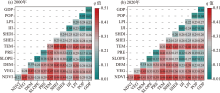
Fig. 3
Interaction detection results of habitat quality impact factors in 2000 and 2020"
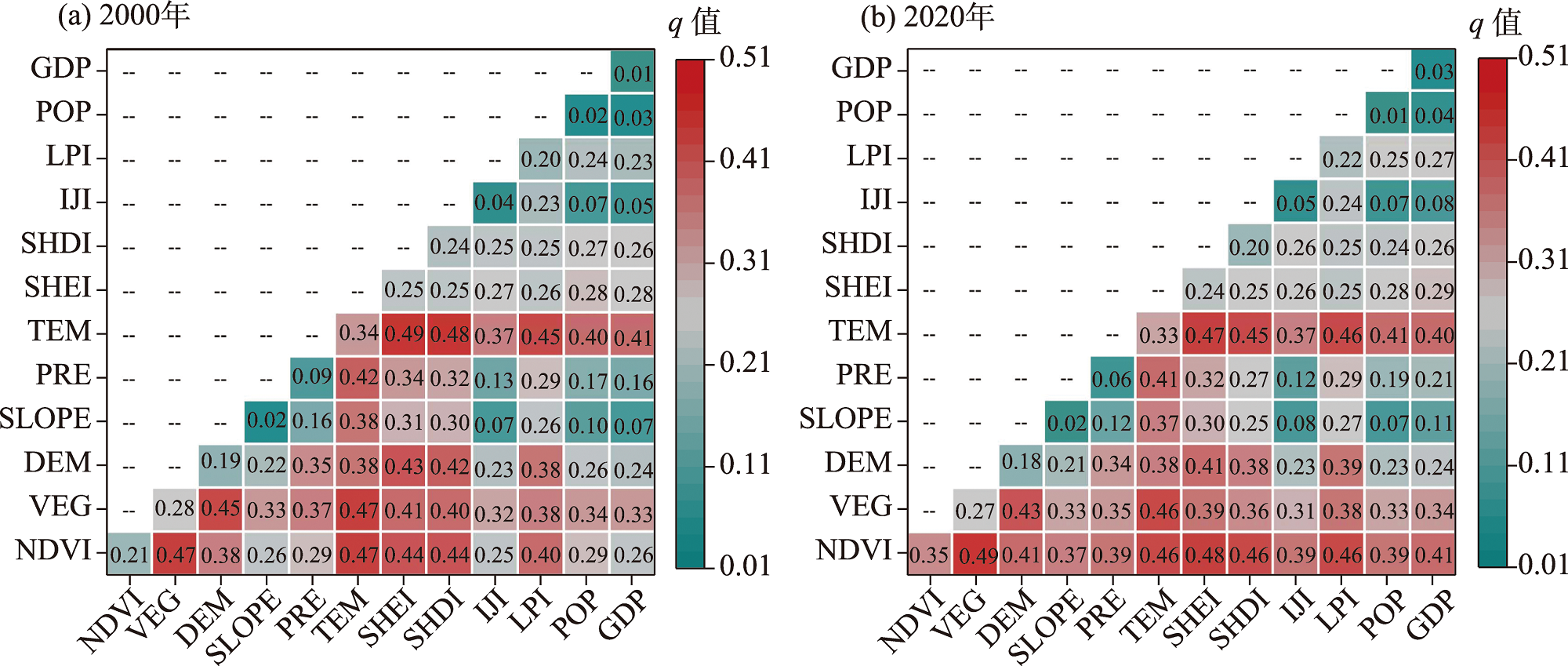

Fig. 4
Spatial characteristics of regression coefficients of influencing factors of GWR model in 2000"

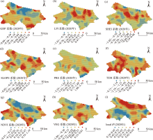
Fig. 5
Spatial characteristics of regression coefficients of influencing factors of GWR model in 2020"

| [1] | Mohan M, Kandya A. Impact of urbanization and land-use/land-cover change on diurnal temperature range: A case study of tropical urban airshed of India using remote sensing data[J]. Science of the Total Environment, 2015, 506: 453-465. |
| [2] |
Fellman J B, Hood E, Dryer W, et al. Stream physical characteristics impact habitat quality for Pacific salmon in two temperate coastal watersheds[J]. PloS one, 2015, 10(7): e0132652.
doi: 10.1371/journal.pone.0132652 |
| [3] |
Hillard E M, Nielsen C K, Groninger J W. Swamp rabbits as indicators of wildlife habitat quality in bottomland hardwood forest ecosystems[J]. Ecological Indicators, 2017, 79: 47-53.
doi: 10.1016/j.ecolind.2017.03.024 |
| [4] | 彭建, 徐飞雄, 吴见, 等. 典型旅游城市生境质量空间分异及其影响机理研究——以黄山市为例[J]. 长江流域资源与环境, 2019, 28(10): 2397-2409. |
| [Peng Jian, Xu Feixiong, Wu Jian, et al. Spatial differentiation of habitat quality in typical tourist city and their Influencing factors mechanisms: A case study of Huang shan City[J]. Resources and Environment in the Yangtze Basin, 2019, 28(10): 2397-2409.] | |
| [5] |
Dominique W, Gabriela S, Klaus E. Predicting habitat quality of protected dry grasslands using landsat NDVI phenology[J]. Ecological Indicators, 2018, 91: 447-460.
doi: 10.1016/j.ecolind.2018.03.081 |
| [6] |
Barbara R, Stefan L. A spatially explicit patch model of habitat quality, integrating spatio-structural indicators[J]. Ecological Indicators, 2018, 94: 128-141.
doi: 10.1016/j.ecolind.2017.04.027 |
| [7] | 粟一帆, 李卫明, 李金京, 等. 桥边河大型底栖动物生境适宜性[J]. 生态学报, 2020, 40(16): 5844-5854. |
| [Su Yifan, Li Weiming, Li Jinjing, et al. Habitat suitability of macroinvertebrates: A case study in Qiaobian River, atributary of Yangtze River, China[J]. Acta Ecologica Sinica, 2020, 40(16): 5844-5854.] | |
| [8] |
Boumans R, Roman J, Altman I, et al. The Multiscale Integrated Model of Ecosystem Services (MIMES): Simulating the interactions of coupled human and natural systems[J]. Ecosystem Services, 2015, 12: 30-41.
doi: 10.1016/j.ecoser.2015.01.004 |
| [9] |
刘永婷, 杨钊, 徐光来, 等. 基于MGWR模型的皖江城市带生境质量对城镇化的响应研究[J]. 地理科学, 2023, 43(2): 280-290.
doi: 10.13249/j.cnki.sgs.2023.02.010 |
|
[Liu Yongting, Yang Zhao, Xu Guanglai, et al. Impacts of urbanization on habitat quality using MGWR models in Wanjiang City Belt[J]. Scientia Geographica Sinica, 2023, 43(2): 280-290.]
doi: 10.13249/j.cnki.sgs.2023.02.010 |
|
| [10] | 提杨, 庄鸿飞, 陈敏豪, 等. 天津市自然保护地与区域生境质量的时空演变格局[J]. 生态学报, 2023, 43(7): 2770-2780. |
| [Ti Yang, Zhuang Hongfei, Chen Minhao, et al. Spatio-temporal evolution pattern of protected areas and regional habitat quality in Tianjin[J]. Acta Ecologica Sinica, 2023, 43(7): 2770-2780.] | |
| [11] | 张海涛, 李加林, 田鹏, 等. 基于土地利用变化的东海区大陆海岸带生境质量时空演变研究[J]. 生态学报, 2023, 43(3): 937-947. |
| [Zhang Haitao, Li Jialin, Tian Peng, et al. Spatio temporal evolution of habitat quality in the East China Sea continental coastal zone based on land use changes[J]. Acta Ecologica Sinica, 2023, 43(3): 937-947.] | |
| [12] | 程静, 王鹏, 陈红翔, 等. 渭河流域生境质量时空演变及其地形梯度效应与影响因素[J]. 干旱区地理, 2023, 46(3): 481-491. |
| [Cheng Jing, Wang Peng, Chen Hongxiang, et al. Spatiotemporal evolution of habitat quality in the Weihe River Basin and its topographic gradient effects and influencing factors[J]. Arid Land Geography, 2023, 46(3): 481-491.] | |
| [13] | 陈实, 金云翔, 黄银兰. 长三角中心区生境质量时空变化及其影响机制[J]. 生态学杂志, 2023, 42(5): 1175-1185. |
|
[Chen Shi, Jin Yunxiang, Huang Yinlan. Spatio-temporal variations of habitat quality and its underlying mechanism in the central region of Yangtze River Delta[J]. Chinese Journal of Ecology, 2023, 42(5): 1175-1185.]
doi: DOI: 10.13292/j.1000-4890.202305.022 |
|
| [14] | 任胤铭, 刘小平, 许晓聪, 等. 基于FLUS-InVEST模型的京津冀多情景土地利用变化模拟及其对生态系统服务功能的影响[J]. 生态学报, 2023, 43(11): 4473-4487. |
| [Ren Yinming, Liu Xiaopin, Xu Xiaocong, et al. Multi scenario simulation of land use change and its impact on ecosystem services in Beijing Tianjin Hebei region based on the FLUS-InVEST model[J]. Acta Ecologica Sinica, 2023, 43(11): 4473-4487.] | |
| [15] | 赵恒伦. 青海省社会经济统计年鉴[M]. 青海: 中国统计出版社, 1986: 251-258. |
| [Zhao Henglun. Social and Economic Statistics Yearbook of Qinghai Province[M]. Qinghai: China Statistics Press, 1986: 251-258.] | |
| [16] | 胡丰, 张艳, 郭宇, 等. 基于PLUS和InVEST模型的渭河流域土地利用与生境质量时空变化及预测[J]. 干旱区地理, 2022, 45(4): 1125-1136. |
| [Hu Feng, Zhang Yan, Guo Yu, et al. Spatial and temporal changes in land use and habitat quality in the Weihe River Basin based on the PLUS and InVEST models and predictions[J]. Arid Land Geography, 2022, 45(4): 1125-1136.] | |
| [17] |
许宝荣, 刘一川, 董莹, 等. 基于InVEST模型的兰州地区生境质量评价[J]. 中国沙漠, 2021, 41(5): 120-129.
doi: 10.7522/j.issn.1000-694X.2021.00049 |
|
[Xu Baorong, Liu Yichuan, Dong Ying, et al. Evaluation of habitat quality in Lan-zhou region based on InVEST model[J]. Journal of Desert Research, 2021, 41(5): 120-129.]
doi: 10.7522/j.issn.1000-694X.2021.00049 |
|
| [18] | 包玉斌, 刘康, 李婷, 等. 基于InVEST模型的土地利用变化对生境的影响——以陕西省黄河湿地自然保护区为例[J]. 干旱区研究, 2015, 32(3): 622-629. |
| [Bao Yubin, Liu Kang, Li Ting, et al. Effects of land use change on habitat based on InVEST model: Taking Yellow River wetland nature reserve in Shaanxi Province as an example[J]. Arid Zone Research, 2015, 32(3): 622-629.] | |
| [19] | 赵庆建, 吴晓珍. 基于InVEST模型的岷江流域土地利用变化对生境质量的影响研究[J]. 生态科学, 2022, 41(6): 1-10. |
| [Zhao Qingjian, WU Xiaozhen. Research on the impact of land use change on habitat quality in Minjiang River Basin based on InVEST Model[J]. Ecological Science, 2022, 41(6): 1-10.] | |
| [20] |
韩艳莉, 陈克龙, 于德永. 土地利用变化对青海湖流域生境质量的影响[J]. 生态环境学报, 2019, 28(10): 2035-2044.
doi: 10.16258/j.cnki.1674-5906.2019.10.014 |
| [Han Yanli, Chen Kelong, Yu Deyong. Evaluation on the impact of land use change on habitat quality in Qinghai Lake Basin[J]. Ecology and Environmental Sciences, 2019, 28(10): 2035-2044.] | |
| [21] | 潘耀, 尹云鹤, 侯文娟, 等. 基于土地利用及植被覆盖变化的黄河源区生境质量时空变化特征[J]. 生态学报, 2022, 42(19): 7978-7988. |
| [Pan Yao, Yin Yunhe, Hou Wenjuan, et al. Spatiotemporal variation of habitat quality in the Source Region of the Yellow River based on land use and vegetation cover changes[J]. Acta Ecologica Sinica, 2022, 42(19): 7978-7988.] | |
| [22] |
王劲峰, 徐成东. 地理探测器: 原理与展望[J]. 地理学报, 2017, 72(1): 116-134.
doi: 10.11821/dlxb201701010 |
|
[Wang Jinfeng, Xu Chengdong. Geodetector: Principle and prospective[J]. Acta Geographica Sinica, 2017, 72(1): 116-134.]
doi: 10.11821/dlxb201701010 |
|
| [23] | 吴艳霞, 刘方南, 陈宝童. 黄河流域下游城市群生境质量时空演变及驱动因素分析[J]. 水土保持通报, 2023, 43(4): 396-404. |
| [Wu Yanxia, Liu Fangnan, Chen Baotong. Spatial and temporal evolution and drivers of habitat quality in lower Yellow River Basin urban agglomeration[J]. Bulletin of Soil and Water Conservation, 2023, 43(4): 396-404.] | |
| [24] | 王琦琨, 武玮, 杨雪琪, 等. 陕西省生境质量时空演变及驱动机制分析[J]. 干旱区研究, 2022, 39(5): 1684-1694. |
| [Wang Qikun, Wu Wei, Yang Xueqi, et al. Spatial-temporal changes and driving factors of habitat quality in Shaanxi Province during the past 20 years[J]. Arid Zone Research, 2022, 39(5): 1684-1694.] | |
| [25] | 刘春芳, 王川. 基于土地利用变化的黄土丘陵区生境质量时空演变特征——以榆中县为例[J]. 生态学报, 2018, 38(20): 7300-7311. |
| [Liu Chunfang, Wang Chuan. Patio-temporal evolution characteristics of habitat quality in the Loess Hilly Region based on land use change: A case study in Yuzhong County[J]. Acta Ecologica Sinica, 2018, 38(20): 7300-7311.] | |
| [26] |
Brunsdon C, Fotheringham A S, Charlton M E. Geographically weighted regression: A method for exploring spatial nonstationarity[J]. Geographical Analysis, 1996, 28(4): 281-298.
doi: 10.1111/gean.1996.28.issue-4 |
| [27] | 陈慧慧. 青海湖景区开发与环湖社区参与旅游现状研究——基于江西沟乡元者村为个案的人类学调查[J]. 青藏高原论坛, 2015, 3(1): 66-71. |
| [Chen Huihui. Research on the development of Qinghai Lake scenic area and the current situation of community participation in tourism around the lake: An anthropological investigation based on Yuanzhi Village in Jiangxi Gou Township as a case study[J]. Qinghai-Tibetan Plateau Forum, 2015, 3(1): 66-71.] | |
| [28] | 杜嘉妮, 李其江, 刘希胜, 等. 青海湖1956—2017年水文变化特征分析[J]. 水生态学杂志, 2020, 41(4): 27-33. |
| [Du Jiani, Li Qijiang, Liu Xisheng, et al. Characterisation of hydrological changes in Qinghai Lake from 1956 to 2017[J]. Journal of Water Ecology, 2020, 41(4): 27-33.] | |
| [29] | 金章东, 张飞, 王红丽, 等. 2005年以来青海湖水位持续回升的原因分析[J]. 地球环境学报, 2013, 4(3): 1355-1362. |
| [Jing Zhangdong, Zhang Fei, Wang Hongli, et al. The reasons of rising water level in Lake Qinghai since 2005[J]. Journal of Earth Environment, 2013, 4(3): 1355-1362.] | |
| [30] |
张洪源, 吴艳红, 刘衍君, 等. 近20年青海湖水量变化遥感分析[J]. 地理科学进展, 2018, 37(6): 823-832.
doi: 10.18306/dlkxjz.2018.06.009 |
|
[Zhang Hongyuan, Wu Yanhong, Liu Yanjun, et al. Water storage variation of the Qinghai Lake in recent decades based on satellite observation[J]. Progress in Geography, 2018, 37(6): 823-832.]
doi: 10.18306/dlkxjz.2018.06.009 |
|
| [31] |
Pratt R N, Kopp G A. Velocity measurements around low-profile, tilted, solar arrays mounted on large flat-roofs, for wall normal wind directions[J]. Journal of Wind Engineering and Industrial Aerodynamics, 2013, 123: 226-238.
doi: 10.1016/j.jweia.2013.09.001 |
| [32] | Thorne J H, Boynton R M, Flint L E, et al. The magnitude and spatial patterns of historical and future hydrologic change in California’s watersheds[J]. Ecosphere, 2015, 6(2): 1-30. |
| [33] |
杨达, 易桂花, 张廷斌, 等. 青藏高原植被生长季NDVI时空变化与影响因素[J]. 应用生态学报, 2021, 32(4): 1361-1372.
doi: 10.13287/j.1001-9332.202104.014 |
| [Yang Da, Yi Guihua, Zhang Tingbin, et al. Spatiotemporal variation and driving factors of growing season NDVI in the Tibetan Plateau, China[J]. Chinese Journal of Applied Ecology, 2021, 32(4): 1361-1372.] | |
| [34] | 马扶林, 刘小伟, 朵莹, 等. 日尺度下水热因子变化对青藏高原高寒草原生产力的影响特征[J]. 生态学报, 2023, 43(9): 3719-3728. |
| [Ma Fulin, Liu Xiaowei, Duo Ying, et al. Effects of daily variation of hydro-thermal factors on alpine grassland productivity on the Qinghai-Tibet Plateau[J]. Acta Ecologica Sinica, 2023, 43(9): 3719-3728.] | |
| [35] |
鲍艳, 王玉琦, 南素兰, 等. 青藏高原植被对未来气候变暖的反馈[J]. 高原气象, 2023, 42(3): 553-563.
doi: 10.7522/j.issn.1000-0534.2021.00109 |
|
[Bao Yan, Wang Yuqi, Nan Sulan, et al. Response of vegetation over the Qinghai-Xizang plateau to projected warming climate[J]. Plateau Meteorology, 2023, 42(3): 553-563.]
doi: 10.7522/j.issn.1000-0534.2021.00109 |
|
| [36] | 谢宝妮. 黄土高原近30年植被覆盖变化及其对气候变化的响应[D]. 杨凌: 西北农林科技大学, 2016. |
| [Xie Baoni. Vegetation Dynamics and Climate Change on the Loess Plateau, China: 1982-2014[D]. Yangling: Northwest A & F University, 2016.] | |
| [37] | 樊应凭, 金晓斌, 陈传钊, 等. 沿海都市区景观格局与生态环境质量的时空演变及关联性分析——以海口市秀英区为例[J]. 现代城市研究, 2023(3): 116-124, 132. |
| [Fan Yingping, Jin Xiaobin, Chen Chuanzhao, et al. Spatial-temporal evolution and correlation analysis of landscape pattern and ecological environment quality in coastal metropolitan area: A case study of Xiuying District, Haikou[J]. Modern Urban Research, 2023(3): 116-124, 132.] | |
| [38] | 张杰, 张剑勇, 马蓝. 黄河流域生态保护与高质量发展耦合协调关系实证分析[J]. 人民黄河, 2024, 46(1): 19-24. |
| [Zhang Jie, Zhang Jianyong, Ma Lan. An empirical analysis of the coupled and coordinated relationship between ecological protection and high-quality development in the Yellow River Basin[J]. People’s Yellow River, 2024, 46(1): 19-24.] | |
| [39] |
Zhu C, Zhang X, Zhou M, et al. Impacts of urbanization and landscape pattern on habitat quality using OLS and GWR models in Hangzhou, China[J]. Ecological Indicators, 2020, 117: 106654.
doi: 10.1016/j.ecolind.2020.106654 |
| [1] | WU Zhaoqiao, LIN Fei, NIU Junjie, GENG Tianwei. Response of ecosystem service to land use pattern change in the Shanxi central urban agglomeration [J]. Arid Zone Research, 2024, 41(7): 1153-1166. |
| [2] | LI Bingjie, FAN Zhitao, QU Zhicheng, YAO Shunyu, SU Xiashu, LIU Dongwei, WANG Lixin. Evaluation and prediction of ecosystem carbon storage in the Inner Mongolia section of the Yellow River Basin based on the InVEST-PLUS model [J]. Arid Zone Research, 2024, 41(7): 1217-1227. |
| [3] | ZHANG Shunxin, WU Zihao, YAN Qingwu, LI Gui’e, MU Shouguo. Spatiotemporal changes in the ecosystem carbon storage on the northern slope of the Tianshan Mountains and simulations based on the PLUS-InVEST model [J]. Arid Zone Research, 2024, 41(7): 1228-1237. |
| [4] | CAI Yuqin, QI Donglin, WANG Liefu, LI Haifeng, ZHANG Deqin. Spatial and temporal evolution characteristics of different grades of cold days in Qinghai Province [J]. Arid Zone Research, 2024, 41(5): 742-752. |
| [5] | GAO Yayu, SONG Yu, ZHAO Tinghong, GAO Jinfang, HE Wenbo, LI Zexia. Spatiotemporal evolution of water yield in the lower Malian River Basin [J]. Arid Zone Research, 2024, 41(5): 776-787. |
| [6] | LIU Rulong, ZHAO Yuanyuan, CHEN Guoqing, CHI Wenfeng, LIU Zhengjia. Assessment of habitat quality in the Yellow River Basin in Inner Mongolia from 1990 to 2020 [J]. Arid Zone Research, 2024, 41(4): 674-683. |
| [7] | LI Jiake, SHAO Zhanlin. Spatiotemporal evolution and prediction of carbon stock in Urumqi City based on PLUS and InVEST models [J]. Arid Zone Research, 2024, 41(3): 499-508. |
| [8] | WANG Yang, FENG Zhuoya, XU Li, GAO Wenxin. Response and influencing factors of habitat quality and land use change in the Tarim River Basin [J]. Arid Zone Research, 2024, 41(12): 2132-2142. |
| [9] | SUN Kuan, SUN Xueyan, TANG Yan, ZHANG Yaling, LIU Fugang, FAN Kesheng, YANG Ziqiong, QU Zhiqiang. Temporal and spatial variations in multi-year surface sensible heat flux in Qinghai Province [J]. Arid Zone Research, 2024, 41(1): 36-49. |
| [10] | SHEN Cao,REN Zongping,LI Peng,WANG Kaibo,LU Kexin,REN Zhengyan,WEI Xiaoyan. Identification of priority areas for ecological compensation under soil and water conservation in Ningxia [J]. Arid Zone Research, 2023, 40(9): 1527-1536. |
| [11] | ZHANG Xiaomin, ZHANG Dongmei, ZHANG Wei. Effects of human activities on carbon storage in the Irtysh River Basin [J]. Arid Zone Research, 2023, 40(8): 1333-1345. |
| [12] | BAO Yubin,WANG Yaozong,LU Feng,LIU Zizeng,MA Dawei,YANG Yong,WU Juan,ZHANG Yongkang. Construction of an ecological security pattern and zoning optimization for territorial space in the Liupan Mountain Area [J]. Arid Zone Research, 2023, 40(7): 1172-1183. |
| [13] | CHEN Shi, HUANG Yinlan, JIN Yunxiang. Spatiotemporal changes of habitat quality before and after the implementation of Grain for Green Project in the middle reaches of the Yellow River [J]. Arid Zone Research, 2023, 40(3): 456-468. |
| [14] | WANG Peng, QIN Sitong, HU Huirong. Spatial-temporal evolution characteristics of land use change and habitat quality in the Lhasa River Basin over the past three decades [J]. Arid Zone Research, 2023, 40(3): 492-503. |
| [15] | LI Suyun, QI Donglin, WEN Tingting, SHI Feifei, QIAO Bin, XIAO Jianshe. The variation characteristics and influencing factors of vapor pressure deficit in Qinghai Province from 1961 to 2020 [J]. Arid Zone Research, 2023, 40(2): 173-181. |
| Viewed | ||||||||||||||||||||||||||||||||||||||||||||||||||
|
Full text 106
|
|
|||||||||||||||||||||||||||||||||||||||||||||||||
|
Abstract 228
|
|
|||||||||||||||||||||||||||||||||||||||||||||||||
Cited |
|
|||||||||||||||||||||||||||||||||||||||||||||||||
| Shared | ||||||||||||||||||||||||||||||||||||||||||||||||||
|
||