干旱区研究 ›› 2021, Vol. 38 ›› Issue (5): 1484-1496.doi: 10.13866/j.azr.2021.05.31 cstr: 32277.14.AZR.20210531
• 生态与环境 • 上一篇
排日海·合力力1,2( ),昝梅1,2(),阿里木江·卡斯木1,2
收稿日期:2021-01-26
修回日期:2021-07-05
出版日期:2021-09-15
发布日期:2021-09-24
作者简介:排日海·合力力(1998-),女,硕士研究生,主要从事干旱区生态环境研究. E-mail: 基金资助:
Pariha Helili1,2(),ZAN Mei1,2(),Alimjan Kasim1,2
Received:2021-01-26
Revised:2021-07-05
Published:2021-09-15
Online:2021-09-24
摘要:
生态环境质量评估对于区域社会经济的可持续发展至关重要。以新疆乌鲁木齐市为研究区,通过对2000年、2010年和2019年3期Landsat系列数据进行预处理,利用主成分分析法构建遥感生态指数(Remote Sensing Ecological Index, RSEI),使用地理探测器中单因子分析和多因子交互作用分析法对RSEI的8个影响因子(人口密度、土地利用类型、海拔高度、经济密度、绿度、湿度、热度和干度)进行影响程度的定量探测,进而揭示出影响研究区生态环境质量的主导因素。结果表明:(1) 2000年、2010年和2019年乌鲁木齐市RSEI均值分别为0.21、0.21、0.23呈增加趋势,研究期内乌鲁木齐市生态变好的面积大于变差的面积,说明乌鲁木齐市的生态环境质量处于转好的状态;(2) 近20 a研究区8个影响因子中单因子热度指标对RSEI的空间分异特征解释力最强;(3) 研究区生态环境的空间分布特征是多种影响因子共同交互作用的结果,在考虑多因子交互作用情景下人口密度,绿度指标和干度指标是区域生态环境质量状况的主要影响因素和关键驱动力。评价区域生态环境质量,了解生态环境状况及掌握其变化规律,不仅有利于促进区域经济可持续发展,而且对于城市生态文明建设具有重要的现实意义和参考价值。
排日海·合力力,昝梅,阿里木江·卡斯木. 乌鲁木齐市生态环境遥感评价及驱动因子分析[J]. 干旱区研究, 2021, 38(5): 1484-1496.
Pariha Helili,ZAN Mei,Alimjan Kasim. Remote sensing evaluation of ecological environment in Urumqi City and analysis of driving factors[J]. Arid Zone Research, 2021, 38(5): 1484-1496.
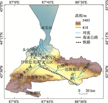
图1
研究区位置示意图"

表1
遥感生态指数的主成分分析"
| 主成分 | 2000年 | 2010年 | 2019年 | |||
|---|---|---|---|---|---|---|
| 特征值 | 贡献率/% | 特征值 | 贡献率/% | 特征值 | 贡献率/% | |
| PC1 | 0.1475 | 82.69 | 0.0629 | 89.02 | 0.0622 | 88.71 |
| PC2 | 0.0276 | 11.68 | 0.0062 | 7.89 | 0.0057 | 5.47 |
| PC3 | 0.0025 | 4.56 | 0.0013 | 2.61 | 0.0032 | 4.43 |
| PC4 | 0.0008 | 1.13 | 0.0002 | 0.48 | 0.0004 | 1.13 |
表2
乌鲁木齐市各年份指标和RSEI的变化"
| 年份 | 统计值 | NDVI | WET | LST | NDBSI | RSEI |
|---|---|---|---|---|---|---|
| 2000 | 最小值 | -1.00 | -0.02 | -20.78 | -0.90 | 0.00 |
| 最大值 | 1.00 | 0.02 | 63.64 | 0.37 | 1.00 | |
| 均值 | -0.02 | 0.01 | 8.93 | 0.02 | 0.21 | |
| 标准差 | 0.06 | 0.00 | 13.86 | 0.09 | 0.30 | |
| 2010 | 最小值 | -0.76 | -0.03 | -18.48 | -0.82 | 0.00 |
| 最大值 | 0.52 | 0.02 | 54.31 | 0.50 | 1.00 | |
| 均值 | -0.03 | 0.00 | 10.07 | 0.02 | 0.21 | |
| 标准差 | 0.10 | 0.00 | 17.25 | 0.07 | 0.32 | |
| 2019 | 最小值 | -1.00 | -0.03 | -16.21 | -0.81 | 0.00 |
| 最大值 | 0.60 | 0.02 | 54.24 | 0.72 | 1.00 | |
| 均值 | 0.03 | 0.01 | 8.87 | -0.11 | 0.23 | |
| 标准差 | 0.06 | 0.09 | 15.20 | 0.18 | 0.33 |

图2
乌鲁木齐市遥感生态指数的等级分布"
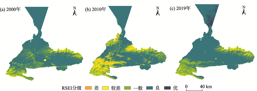
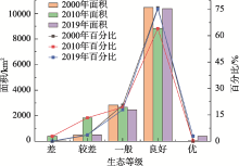
图3
各年份生态等级和面积比例统计"

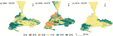
图4
2000—2019年乌鲁木齐市RSEI变化监测"

表3
2000—2019年乌鲁木齐市RSEI等级变化监测"
| 变化 | 2000—2010年 | 2010—2019年 | 2000—2019年 | |||
|---|---|---|---|---|---|---|
| 面积/km2 | 占比/% | 面积/km2 | 占比/% | 面积/km2 | 占比/% | |
| 恶化 | 0.001 | 0.00 | 0.00 | 0.00 | 0 | 0.00 |
| 变差 | 156.37 | 1.14 | 1104.65 | 8.03 | 56.91 | 0.41 |
| 不变 | 9058.09 | 65.75 | 7184.73 | 52.21 | 10621 | 77.10 |
| 变好 | 4435.82 | 32.20 | 5470.91 | 39.76 | 3097.87 | 22.49 |
| 优化 | 125.88 | 0.91 | 0.02 | 0.00 | 0.37 | 0.00 |

图5
探测因子空间分布"
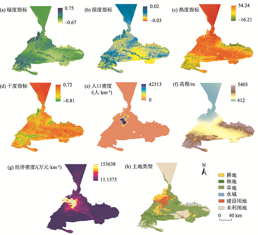
表4
单因子探测结果"
| 探测因子 | 2000年 | 2010年 | 2019年 | ||||||
|---|---|---|---|---|---|---|---|---|---|
| q值 | P值 | q排序 | q值 | P值 | q排序 | q值 | P值 | q排序 | |
| 绿度指标 | 0.179 | 0 | 7 | 0.349 | 0 | 3 | 0.095 | 0 | 5 |
| 湿度指标 | 0.526 | 0 | 2 | 0.168 | 0 | 6 | 0.326 | 0 | 3 |
| 热度指标 | 0.857 | 0 | 1 | 0.706 | 0 | 1 | 0.653 | 0 | 1 |
| 干度指标 | 0.252 | 0 | 4 | 0.368 | 0 | 2 | 0.046 | 0 | 8 |
| 人口密度 | 0.07 | 1 | 8 | 0.067 | 0 | 8 | 0.166 | 0 | 4 |
| 土地利用 | 0.235 | 0 | 5 | 0.077 | 0 | 7 | 0.091 | 0 | 6 |
| 海拔 | 0.2 | 0 | 6 | 0.345 | 0 | 4 | 0.52 | 0 | 2 |
| 经济密度 | 0.263 | 0 | 3 | 0.199 | 0 | 5 | 0.072 | 0 | 7 |
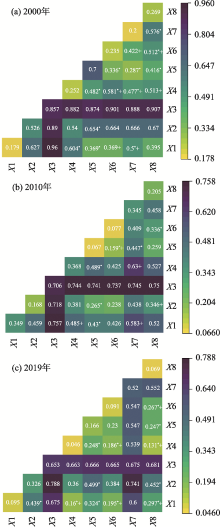
图6
交互探测器结果 注:X1表示绿度指标,X2表示湿度指标,X3表示热度指标,X4表示干度指标,X5表示人口密度,X6表示土地利用,X7表示海拔高度,X8表示经济密度;*表示非线性增强,无标记的是双因子增强,+表示没有显著性差异,无标记是显著性差异;颜色越深代表双因子增强对生态环境指数的解释力越强。"

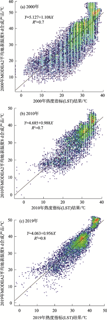
图7
反演的2000年、2010年和2019年的LST数据与MOD11A2产品的比较"

表5
探测因子组合"
| 年份 | 交互因子 | q(X1∩X2) | q(X1)+q(X2) | C | 影响模式 |
|---|---|---|---|---|---|
| 2000 | NDVI∩NDBSI | 0.604 | 0.431 | 0.173 | 非线性增强 |
| 人口密度∩NDBSI | 0.482 | 0.322 | 0.160 | 非线性增强 | |
| 人口密度∩NDVI | 0.369 | 0.249 | 0.120 | 非线性增强 | |
| DEM∩经济密度 | 0.576 | 0.463 | 0.113 | 非线性增强 | |
| 2010 | 土地利用∩经济密度 | 0.336 | 0.276 | 0.060 | 非线性增强 |
| 人口密度∩NDBSI | 0.489 | 0.435 | 0.054 | 非线性增强 | |
| 人口密度∩WET | 0.265 | 0.235 | 0.030 | 非线性增强 | |
| 人口密度∩NDVI | 0.430 | 0.416 | 0.014 | 非线性增强 | |
| 2019 | 人口密度∩NDVI | 0.324 | 0.261 | 0.063 | 非线性增强 |
| 人口密度∩NDBSI | 0.248 | 0.212 | 0.036 | 非线性增强 | |
| NDVI∩WET | 0.439 | 0.421 | 0.018 | 非线性增强 | |
| 人口密度∩经济密度 | 0.247 | 0.238 | 0.009 | 非线性增强 |
| [1] | 王东升, 王小磊, 雷泽勇. 基于遥感生态指数的阜新市生态质量评估[J]. 生态科学, 2020, 39(3): 88-94. |
| [ Wang Dongsheng, Wang Xiaolei, Lei Zeyong. Ecological change assessment of Fuxin based on remote sensing ecological index[J]. Ecological Science, 2020, 39(3): 88-94. ] | |
| [2] |
杨江燕, 吴田, 潘肖燕, 等. 基于遥感生态指数的雄安新区生态质量评估[J]. 应用生态学报, 2019, 30(1): 277-284.
doi: 10.13287/j.1001-9332.201901.017 pmid: 30907550 |
|
[ Yang Jiangyan, Wu Tian, Pan Xiaoyan, et al. Ecological quality assessment of Xiongan New Area based on remote sensing ecological index[J]. Chinese Journal of Applied Ecology, 2019, 30(1) : 277-284. ]
doi: 10.13287/j.1001-9332.201901.017 pmid: 30907550 |
|
| [3] | 宋媛, 石惠春, 谢敏慧, 等. 2000—2017年甘肃省生态环境质量时空演变格局及其影响因素[J]. 生态学杂志, 2019, 38(12): 3800-3808. |
| [ Song Yuan, Shi Huichun, Xie Minhui, et al. Spatiotemporal evolution pattern and influencing factors of eco-environmental quality in Gansu from 2000 to 2017[J]. Chinese Journal of Ecology, 2019, 38(12): 3800-3808. ] | |
| [4] | 杨胜天, 刘昌明, 杨志峰, 等. 南水北调西线调水工程区的自然生态环境评价[J]. 地理学报, 2002, 57(1): 11-18. |
| [ Yang Shengtian, Liu Changming, Yang Zhifeng, et al. Natural Eco-environmental evaluation of west route area of interbasin water transfer project[J]. Acta Geographic Sinica, 2002, 57(1): 11-18. ] | |
| [5] | 任志远, 李晶. 陕南秦巴山区植被生态功能的价值测评[J]. 地理学报, 2003, 58(4): 503-511. |
| [ Ren Zhiyuan, Li Jing. The valuation of ecological services from the vegetation ecosystems in the Qinling-Daba mountains[J]. Acta Geographic Sinica, 2003, 58(4): 503-511. ] | |
| [6] | 李晓文, 方精云, 朴世龙. 近10年来长江下游土地利用变化及其生态环境效应[J]. 地理学报, 2003, 58(5): 659-667. |
| [ Li Xiaowen, Fang Jingyun, Piao Shilong. Landuse changes and its implication to the ecological consequences in lower Yangze region[J]. Acta Geographic Sinica, 2003, 58(5): 659-667. ] | |
| [7] | 阿里木江·卡斯木. 人口密度、夜间光数据及MODIS的全球城市分类[J]. 遥感信息, 2018, 33(1): 86-92. |
| [ Alimujiang Kasimu. Global urban characterization using population density, DMSP data and MODIS data[J]. Remote Sensing Information, 2018, 33(1): 86-92. ] | |
| [8] | 高炜, 安如, 王喆. 基于微波遥感技术的干旱监测指数及其应用研究——以三江源区为例[J]. 干旱区研究, 2017, 34(3): 541-550. |
| [ Gao Wei, An Ru, Wang Zhe. Drought index and its application based on microwave remote sensing technology: A case study in the Three-River Headwaters Region[J]. Arid Zone Research, 2017, 34(3): 541-550. ] | |
| [9] |
Sullivan C A, Skeffington M S, Gormally M J, et al. The ecological status of grasslands on lowland farmlands in western Ireland and implications for grassland classification and nature value assessment[J]. Biological Conservation, 2010, 143: 1529-1539.
doi: 10.1016/j.biocon.2010.03.035 |
| [10] | Li Wangming, Wang Jianzheng, Ge Dandong. Analysis of ecological carrying capacity change and driving factors at urban fringe: A case of Hangzhou City[J]. Journal of Zhejiang University(Engineering Science), 2008, 42(1): 39-43. |
| [11] |
Ochoa-Gaona S, Kampichler C, de Jong B H J, et al. Amulti-criterion index for the evaluation of local tropical forest conditions in Mexico[J]. Forest Ecology Management, 2010, 260: 618-627.
doi: 10.1016/j.foreco.2010.05.018 |
| [12] |
阿布都米吉提·阿布力克木, 阿里木江·卡斯木, 艾里西尔·库尔班, 等. 近40年台特玛-康拉克湖泊群水域变化遥感监测[J]. 湖泊科学, 2014, 26(1): 46-54.
doi: 10.18307/2014.0106 |
|
[ Ablekim Abdimijit, Kasimu Alimujiang, Kurban Alishir, et al. Monitoring the water area changes in Tetima-Kanglayka lakes region over the past four decades by remotely sensed data[J]. Journal of Lake Sciences, 2014, 26(1): 46-54. ]
doi: 10.18307/2014.0106 |
|
| [13] |
张瑞钢, 莫兴国, 林忠辉. 滹沱河上游山区近50年蒸散变化及主要影响因子分析[J]. 地理科学, 2012, 32(5): 628-634.
doi: 10.13249/j.cnki.sgs.2012.05.628 |
|
[ Zhang Ruigang, Mo Xingguo, Lin Zhonghui. The trend and the principal influence factors of evapotranspiration in Hutuo River Basin during last 50 years[J]. Scientia Geographica Sinica, 2012, 32(5): 628-634. ]
doi: 10.13249/j.cnki.sgs.2012.05.628 |
|
| [14] | 李佩武, 李贵才, 陈莉, 等. 深圳市植被径流调节及其生态效益分析[J]. 自然资源学报, 2009, 24(7): 1223-1233. |
| [ Li Peiwu, Li Guicai, Chen Li, et al. Analysis of Shenzhen’s vegetation: Flood control and ecological benefit[J]. Journal of Natural Resources, 2009, 24(7): 1223-1233. ] | |
| [15] | 崔秋洋, 潘云, 杨雪. 基于Landsat 8遥感影像的北京市平原区不透水层盖度估算[J]. 首都师范大学学报(自然科学版), 2015, 36(2): 89-92. |
| [ Cui Qiuyang, Pan Yun, Yang Xue. Estimation of the impermeable layer coverage in the plain area of Beijing based on Landsat 8 remote sensing image[J]. Journal of Capital Normal University(Natural Science Edition), 2015, 36(2): 89-92. ] | |
| [16] | 徐涵秋. 区域生态环境变化的遥感评价指数[J]. 中国环境科学, 2013, 33(5): 889-897. |
| [ Xu Hanqiu. A remote sensing index for assessment of regional ecological changes[J]. China Environmental Science, 2013, 33(5): 889-897. ] | |
| [17] | 张亚球, 姜放, 纪梦达, 等. 基于遥感指数的区县级生态环境评价[J]. 干旱区研究, 2020, 37(6): 1598-1605. |
| [ Zhang Yaqiu, Jiang Fang, Ji Mengda, et al. Assessment of the ecological environment at district and county level based on remote sensing index[J]. Arid Zone Research, 2020, 37(6): 1598-1605. ] | |
| [18] |
王劲峰, 徐成东. 地理探测器: 原理与展望[J]. 地理学报, 2017, 72(1): 116-134.
doi: 10.11821/dlxb201701010 |
|
[ Wang Jinfeng, Xu Chengdong. Geodetector: Principle and prospective[J]. Acta Geographic Sinica, 2017, 72(1): 116-134. ]
doi: 10.11821/dlxb201701010 |
|
| [19] | 郭泽呈, 魏伟, 庞素菲, 等. 基于SPCA和遥感指数的干旱内陆河流域生态脆弱性时空演变及动因分析——以石羊河流域为例[J]. 生态学报, 2019, 39(7): 2558-2572. |
| [ Guo Zecheng, Pang Sufei, et al. Spatio-temporal evolution and motivation analysis of ecological vulnerability in Arid Inland River Basin based on SPCA and remote sensing index: A case study on the Shiyang River Basin[J]. Acta Ecologica Sinica, 2019, 39(7): 2558-2572. ] | |
| [20] | 文广超, 赵梅娟, 谢洪波, 等. 伊犁河谷西部土地植被覆盖演化及驱动力分析[J]. 干旱区研究, 2021, 38(3): 843-854. |
| [ Wan Guangchao, Zhao Meijuan, Xie Hongbo, et al. Analysis of land vegetation cover evolution and driving forces in the western part of the Ili River Valley[J]. Arid Zone Research, 2021, 38(3): 843-854. ] | |
| [21] | 张亚如, 张军民. 城镇化与经济发展的时空相互作用机制研究——以新疆为例[J]. 干旱区地理, 2020, 43(3): 839-848. |
| [ Zhang Yaru, Zhang Junmin. Spatio-temporal interaction mechanism of urbanization and economic development: A case of Xinjiang[J]. Arid Land Geography, 2020, 43(3): 839-848. ] | |
| [22] | 李世海. 乌鲁木齐市大气环境质量现状及对策[J]. 区域治理, 2019(24): 54-57. |
| [ Li Shihai. Present situation and countermeasure of atmospheric environment quality in Urumqi[J]. Regional Governance, 2019(24): 54-57. ] | |
| [23] | 魏伟, 颉耀文, 魏晓旭, 等. 基于CLUE-S模型和生态安全格局的石羊河流域土地利用优化配置[J]. 武汉大学学报(信息科学版), 2017, 42(9): 1306-1315. |
| [ Xie Yaowen, Wei Xiaoxu, et al. Land use optimization based on CLUE-S model and ecological security scenario in Shiyang river basin[J]. Geomatics and Information Science of Wuhan University, 2017, 42(9): 1306-1315. ] | |
| [24] | Liu H, Jiang D, Yang X, et al. Spatialization approach to 1 km grid GDP supported by remote sensing[J]. Geo-Information Science, 2005, 7(2): 120-123. |
| [25] | 易玲, 熊利亚, 杨小唤. 基于GIS技术的GDP空间化处理方法[J]. 甘肃科学学报, 2006, 18(2): 54-58. |
| [ Yi Ling, Xiong Liya, Yang Xiaohuan. Method of Pixelizing GDP data based on the GIS[J]. Journal of Gansu Sciences, 2006, 18(2): 54-58. ] | |
| [26] | 王志杰, 苏嫄. 南水北调中线汉中市水源地生态脆弱性评价与特征分析[J]. 生态学报, 2018, 38(2): 432-442. |
| [ Wang Zhijie, Su Yuan. Analysis of eco-environmental vulnerability characteristics of Hanzhong City, near the water source midway along the route of the south-to-north water transfer project, China[J]. Acta Ecologica Sinica, 2018, 38(2): 432-442. ] | |
| [27] | 徐涵秋. 城市遥感生态指数的创建及其应用[J]. 生态学报, 2013, 33(24): 7853-7862. |
| [ Xu Hanqiu. A remote sensing urban ecological index and its application[J]. Acta Ecologica Sinica, 2013, 33(24): 7853-7862. ] | |
| [28] | 王丽春, 焦黎, 来风兵, 等. 基于遥感生态指数的新疆玛纳斯湖湿地生态变化评价[J]. 生态学报, 2019, 39(8): 2963-2972. |
| [ Wang Lichun, Jiao Li, Lai Fengbin, et al. Evaluation of ecological changes based on a remote sensing ecological index in a Manas Lake wetland, Xinjiang[J]. Acta Ecologica Sinica, 2019, 39(8): 2963-2972. ] | |
| [29] |
Huang C, Wylie B, Yang L, et al. Derivation of a tasselled cap transformation based on Landsat 7 at satellite reflectance[J]. International Journal of Remote Sensing, 2002, 23(6): 1741-1748.
doi: 10.1080/01431160110106113 |
| [30] | 徐涵秋. 水土流失区生态变化的遥感评估[J]. 农业工程学报, 2013, 29(7): 91-97, 294. |
| [ Xu Hanqiu. Remote sensing assessment of ecological changes in soil and water loss areas[J]. Transactions of the Chinese Society of Agricultural Engineering, 2013, 29(7): 91-97, 294. ] | |
| [31] |
Nichol J. Remote sensing of urban heat islands by day and night[J]. Photogrammetric Engineering and Remote Sensing, 2005, 71(6): 613-621.
doi: 10.14358/PERS.71.5.613 |
| [32] | 蒋博文. 基于PCA变换的多光谱图像降维方法研究[J]. 信息技术, 2012, 36(8): 98-101. |
| [ Jiang Bowen. Method of multi-spectral images reduce-dimensions based on PCA[J]. Information Technology, 2012, 36(8): 98-101. ] | |
| [33] | 王静, 姚顺波, 刘天军. 退耕还林(草)工程实施以来降水利用效率演变格局及归因——以宝鸡地区为例[J]. 干旱区研究, 2020, 37(5): 1233-1245. |
| [ Wang Jing, Yao Shunbo, Liu Tianjun. The evolution pattern and attribution of rainfall use efficiency since the implementation of the project of returning farmland to forest (grass): A case study in Baoji[J]. Arid Zone Research, 2020, 37(5): 1233-1245. ] | |
| [34] | 朱增云, 阿里木江·卡斯木. 基于地理探测器的伊犁谷地生境质量时空演变及其影响因素[J]. 生态学杂志, 2020, 39(10): 3408-3420. |
| [ Zhu Zengyun, Alimujiang Kasimu. Spatial-temporal evolution of habital quality in Yili Valley based on geographical detectors and its influencing factors[J]. Chinese Journal of Ecology, 2020, 39(10): 3408-3420. ] | |
| [35] | 高鹏文, 阿里木江·卡斯木, 图尔荪阿依·如孜, 等. 哈密市生态环境效益时空分析[J]. 干旱区研究, 2020, 37(4): 1057-1067. |
| [ Gao Pengwen, Alimujiang Kasimu, Tursunayi Ruzi, et al. Temporal and spatial analysis of ecological environment improvement in Hami City[J]. Arid Zone Research, 2020, 37(4): 1057-1067. ] | |
| [36] | 杨保华, 杨清华, 陈剑虹. 关于《生态环境状况评价技术规范(试行)》中土地退化指数的权重及计算方法的探讨[J]. 生态与农村环境学报, 2011, 27(3): 103-107. |
| [ Yang Baohua, Yang Qinghua, Chen Jianhong. Weight of land (soil) degradation indeces and optimization of their calculation in “echnical criteria or evaluation of ecological environment (Trial)”[J]Journal of Ecology and Rural environment, 2011, 27(3): 103-107. ] | |
| [37] | 蔡贤, 杜晓初. 基于遥感生态指数的鄂州市生态环境质量评估[J]. 湖北大学学报(自然科学版), 2020, 42(3): 233-239, 246. |
| [ Cai Xian, Du Xiaochu. Eco-environment quality assessment of Ezhou City based on RSEI[J]. Journal of Hubei University (Natural Science Edition), 2020, 42(3): 233-239, 246. ] | |
| [38] | 孙灏, 马立茹, 蔡创创, 等. 干旱区地表温度和热岛效应演变研究——以宁夏沿黄城市带为例[J]. 干旱区地理, 2020, 43(3): 694-705. |
| [ Sun Hao, Ma Liru, Cai Chuangchuang, et al. Evolution of surface temperature and heat island effect in arid areas: A case of city belt along the Yellow River in Ningxia[J]. Arid Land Geography, 2020, 43(3): 694-705. ] | |
| [39] | 高焕霖, 张廷龙, 樊华烨, 等. 基于地理探测器的杨凌示范区生态环境质量影响因素定量分析[J]. 西北林学院学报, 2020, 35(5): 185-194. |
| [ Gao Huanlin, Zhang Tinglong, Fan Huaye, et al. Quantitative analysis of the factors affecting ecological environment quality in Yangling demonstration zone based on geograohical detector[J]. Journal of Northwest Forestry University, 2020, 35(5): 185-194. ] | |
| [40] |
宋慧敏, 薛亮. 基于遥感生态指数模型的渭南市生态环境质量动态监测与分析[J]. 应用生态学报, 2016, 27(12): 3913-3919.
doi: 10.13287/j.1001-9332.201612.024 pmid: 29704350 |
|
[ Song Huimin, Xue Liang. Dynamic monitoring and analysis of ecological environment in Weinan City, Northwest China based on RSEI model[J]. Chinese Journal of Applied Ecology, 2016, 27(12): 3913-3919. ]
doi: 10.13287/j.1001-9332.201612.024 pmid: 29704350 |
|
| [41] | Song Y, Wang J, Ge Y, et al. An optimal parameters-based geographical detector model enhances geographic characteristics of explanatory variables for spatial heterogeneity analysis: Cases with different types of spatial data[J]GIScience & Remote Sensing, 2020, 5: 593-610. |
| [1] | 张文睿, 孙栋元, 王亦可, 杨俊, 兰立军, 靳虎甲, 徐裕. 河西走廊水资源-生态环境-社会经济系统耦合关系及时空分异[J]. 干旱区研究, 2024, 41(9): 1527-1537. |
| [2] | 魏疆, 宋丹丹, 赵丽莉, 赵彩欣, 王凌羲. 乌鲁木齐市PM2.5中碳组分污染特征及来源解析[J]. 干旱区研究, 2024, 41(8): 1323-1330. |
| [3] | 王怡雯, 马瑶瑶, 史培军, 张钢锋. 干旱区光伏电站运营对局地生态环境的影响[J]. 干旱区研究, 2024, 41(8): 1423-1433. |
| [4] | 周建伟, 罗君, 马雪洋. 拉萨河流域土地利用与生态系统服务价值时空演变及驱动因素[J]. 干旱区研究, 2024, 41(6): 1021-1031. |
| [5] | 侯嘉烨, 李建华, 王佳蓉, 马海涛, 强泽楷, 樊新刚. 基于SA-RSEI模型的盐池县生态质量演变研究[J]. 干旱区研究, 2024, 41(6): 1045-1058. |
| [6] | 唐可欣, 郭建斌, 何亮, 陈林, 万龙. 中国旱区GPP时空演变特征及影响因素研究[J]. 干旱区研究, 2024, 41(6): 964-973. |
| [7] | 李文秀, 燕振刚. 基于地理探测器的甘肃农牧交错带土地利用时空演化及其驱动机制[J]. 干旱区研究, 2024, 41(4): 590-602. |
| [8] | 赵东颖, 蒙仲举, 孟芮冰, 马泽. 乌兰布和沙漠风沙入黄段植被覆盖动态变化特征及驱动力[J]. 干旱区研究, 2024, 41(4): 639-649. |
| [9] | 刘如龙, 赵媛媛, 陈国清, 迟文峰, 刘正佳. 内蒙古黄河流域1990—2020年生境质量评估[J]. 干旱区研究, 2024, 41(4): 674-683. |
| [10] | 徐铭璟, 冯强, 吕萌. 生态系统服务权衡及其影响因素——以黄河流域山西段为例[J]. 干旱区研究, 2024, 41(3): 467-479. |
| [11] | 程秋连, 刘杰, 杨治纬, 张天意, 王斌. 独库高速阿尔先沟段雪崩空间分布及因子探测[J]. 干旱区研究, 2024, 41(2): 220-229. |
| [12] | 许宁, 李治国, 梁雪悦, 周晓莹. 基于地形梯度的青藏高原冰川分布格局及成因[J]. 干旱区研究, 2024, 41(2): 230-239. |
| [13] | 严莉, 曹广超, 康利刚, 刘梦琳, 叶得力. 基于InVEST模型的共和县生境质量时空变化及驱动因素[J]. 干旱区研究, 2024, 41(2): 314-325. |
| [14] | 王思楠, 吴英杰, 王宏宙, 黎明扬, 王飞, 张雯颖, 马小茗, 于向前. 基于地理探测器的鄂尔多斯干旱时空变化驱动因素分析[J]. 干旱区研究, 2024, 41(12): 1981-1991. |
| [15] | 马正权, 闫劲烨, 帕丽达·牙合甫, 阿力木·阿巴斯. 乌鲁木齐市和喀什市近地面O3变化特征及潜在源研究[J]. 干旱区研究, 2024, 41(12): 2004-2014. |
|
||