干旱区研究 ›› 2024, Vol. 41 ›› Issue (9): 1527-1537.doi: 10.13866/j.azr.2024.09.09
张文睿1( ), 孙栋元1(), 王亦可1, 杨俊2, 兰立军2, 靳虎甲2, 徐裕2
收稿日期:2023-10-28
修回日期:2023-12-19
出版日期:2024-09-15
发布日期:2024-09-25
通讯作者:
孙栋元. E-mail: sundy@gsau.edu.cn作者简介:张文睿(2001-),女,硕士研究生,主要从事水文与水资源研究. E-mail: zhangwr@st.gsau.edu.cn
基金资助:
ZHANG Wenrui1(), SUN Dongyuan1(), WANG Yike1, YANG Jun2, LAN Lijun2, JIN Hujia2, XU Yu2
Received:2023-10-28
Revised:2023-12-19
Published:2024-09-15
Online:2024-09-25
摘要:
推进水资源、生态环境与社会经济系统协调发展为促进区域经济增长、社会进步和生态和谐与高质量发展提供技术支撑。文章基于修正耦合协调度模型评价河西走廊水资源-生态环境-社会经济系统耦合协调水平,运用灰色关联度模型和泰尔指数揭示驱动因素和空间异质性,并利用趋势面映射耦合协调度全域分布。结果表明:(1) 由经济发展带动水资源-经济-生态系统综合发展水平逐年上升,综合发展指数由2006年0.29增长至2021年0.65。(2) 河西走廊水资源子系统、经济子系统、生态子系统两两之间的耦合协调度呈不同趋势上升,水资源-生态-经济系统耦合度发展处于颉颃阶段向磨合阶段升级;协调度经历“轻度失调衰退-濒临失调衰退-勉强协调发展-初级协调发展-中级协调发展”五个阶段。(3) 区域空间异质性逐渐发展为减小趋势,2021年空间分布表现出东南部发展优于西北部格局,金昌和张掖逐步成为河西发展优势区域。(4) 城市化率、排污总量、节水灌溉面积对河西走廊水资源-生态环境-社会经济耦合发展起到较大的驱动作用。研究结果对河西走廊经济-生态-水资源系统协同发展具有一定的借鉴意义。
张文睿, 孙栋元, 王亦可, 杨俊, 兰立军, 靳虎甲, 徐裕. 河西走廊水资源-生态环境-社会经济系统耦合关系及时空分异[J]. 干旱区研究, 2024, 41(9): 1527-1537.
ZHANG Wenrui, SUN Dongyuan, WANG Yike, YANG Jun, LAN Lijun, JIN Hujia, XU Yu. Coupling relationship and spatiao-temporal differentiation of the water resources-ecological environment-social economic system in the Hexi Corridor[J]. Arid Zone Research, 2024, 41(9): 1527-1537.
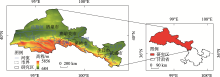
图1
研究区示意图"

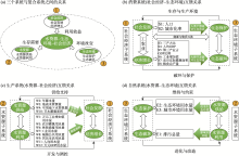
图2
耦合关系层次关联图"
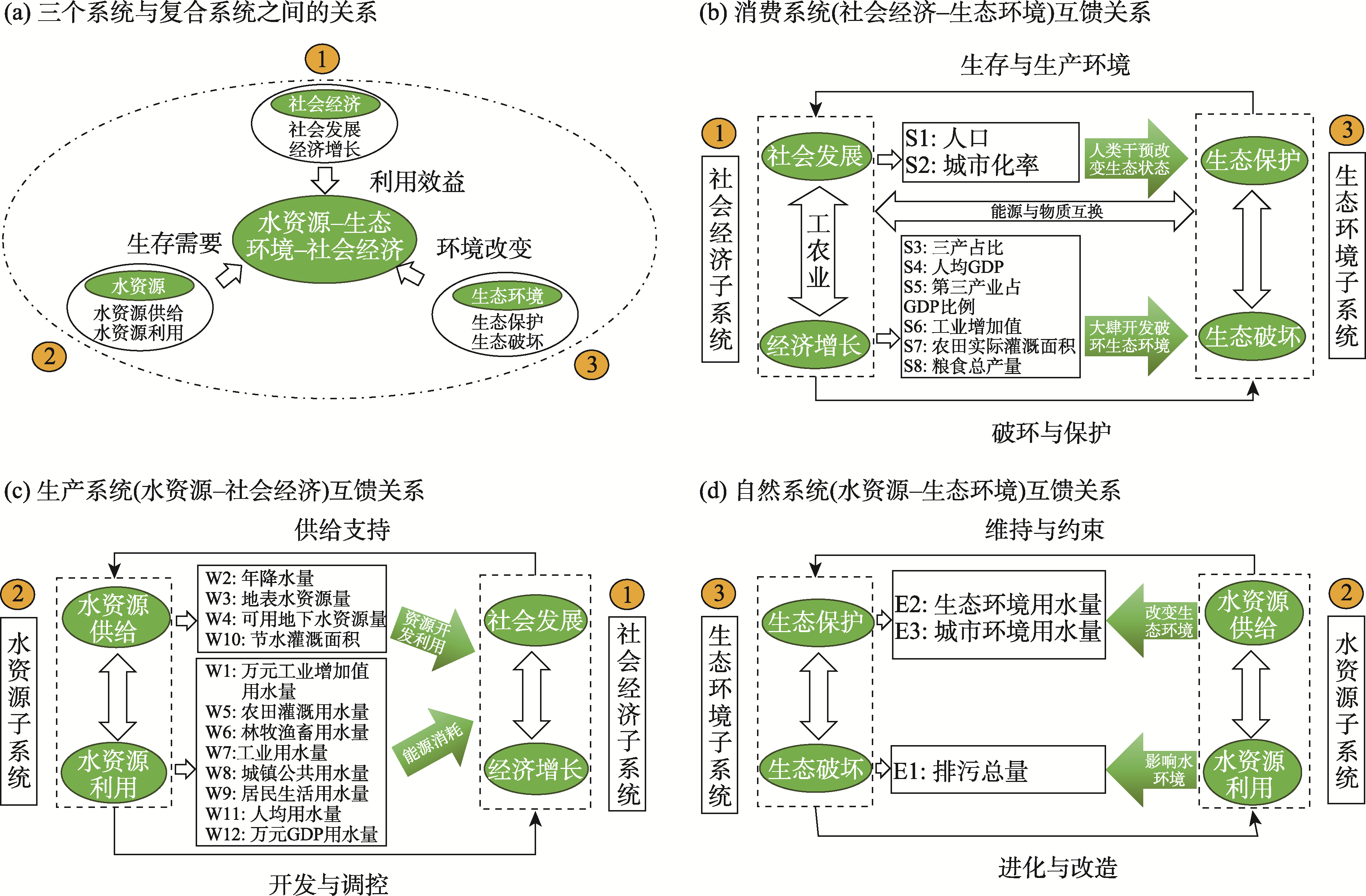
表1
指标体系构建"
| 目标层 | 指标层 | 指标属性 | 指标编号 | 变异系数法权重 | 层次分析法权重 | 综合权重 |
|---|---|---|---|---|---|---|
| 社会经济 | 人口/104人 | + | S1 | 0.02 | 0.07 | 0.04 |
| 城市化率/% | + | S2 | 0.06 | 0.11 | 0.09 | |
| 三产占比/% | + | S3 | 0.29 | 0.10 | 0.19 | |
| 人均GDP/104元 | + | S4 | 0.17 | 0.12 | 0.15 | |
| 第三产业占GDP比例/% | + | S5 | 0.14 | 0.17 | 0.15 | |
| 工业增加值/108元 | + | S6 | 0.17 | 0.15 | 0.16 | |
| 农田实际灌溉面积/hm2 | + | S7 | 0.06 | 0.13 | 0.10 | |
| 粮食总产量/104 t | + | S8 | 0.09 | 0.15 | 0.12 | |
| 生态环境 | 排污总量/108 t | - | E1 | 0.07 | 0.16 | 0.12 |
| 生态环境用水量/108 m3 | + | E2 | 0.46 | 0.54 | 0.50 | |
| 城市环境用水量/108 m3 | + | E3 | 0.47 | 0.30 | 0.38 | |
| 水资源 | 万元工业增加值用水量/108 m3 | - | W1 | 0.10 | 0.08 | 0.09 |
| 年降水量/mm | + | W2 | 0.04 | 0.09 | 0.06 | |
| 地表水供水量/108 m3 | + | W3 | 0.03 | 0.08 | 0.06 | |
| 地下水供水量/108 m3 | + | W4 | 0.09 | 0.08 | 0.08 | |
| 农田灌溉用水量/108 m3 | - | W5 | 0.03 | 0.09 | 0.06 | |
| 林牧渔畜用水量/108 m3 | - | W6 | 0.03 | 0.08 | 0.06 | |
| 工业用水量/108 m3 | - | W7 | 0.07 | 0.08 | 0.08 | |
| 城镇公共用水量/108 m3 | - | W8 | 0.07 | 0.08 | 0.08 | |
| 居民生活用水量/108 m3 | - | W9 | 0.07 | 0.09 | 0.08 | |
| 节水灌溉面积/hm2 | + | W10 | 0.05 | 0.08 | 0.06 | |
| 人均用水量/L | - | W11 | 0.17 | 0.09 | 0.13 | |
| 万元GDP用水量/m3 | - | W12 | 0.25 | 0.08 | 0.16 |
表2
系统耦合度与协调发展的区间划分评价标准"
| 不可接受区间 | 可接受区间 | |||||
|---|---|---|---|---|---|---|
| 区间 | 协调发展度 | 耦合度 | 区间 | 协调发展度 | 耦合度 | |
| 0~0.09 | 极度失调衰退 | 低水平耦合状态 | 0.50~0.59 | 勉强协调发展 | 磨合阶段 | |
| 0.10~0.19 | 严重失调衰退 | 0.60~0.69 | 初级协调发展 | |||
| 0.20~0.29 | 中度失调衰退 | 0.70~0.79 | 中级协调发展 | |||
| 0.30~0.39 | 轻度失调衰退 | 颉颃阶段 | 0.80~0.89 | 良好协调发展 | 高水平耦合阶段 | |
| 0.40~0.49 | 濒临失调衰退 | 0.90~1.00 | 优质协调发展 | |||
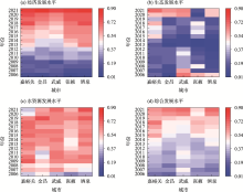
图3
河西走廊水资源-社会经济-生态综合评价指数"

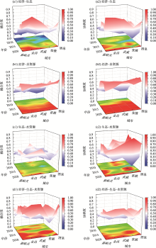
图4
河西走廊水资源-社会经济-生态子系统间的耦合协调度 注:图4a1~4d1为耦合度;图4a2~4d2为耦合协调度。"

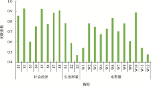
图5
河西走廊复合系统驱动因素关联系数 注:图中指标编号的含义参见表1。"

表3
河西走廊水资源-生态-社会经济系统耦合协调度空间分异"
| 年份 | 耦合协调度 | 泰尔指数 | 年份 | 耦合协调度 | 泰尔指数 |
|---|---|---|---|---|---|
| 2006年 | 0.34 | 0.0119 | 2014年 | 0.43 | 0.0151 |
| 2007年 | 0.38 | 0.0058 | 2015年 | 0.50 | 0.0122 |
| 2008年 | 0.37 | 0.0050 | 2016年 | 0.56 | 0.0067 |
| 2009年 | 0.36 | 0.0037 | 2017年 | 0.60 | 0.0038 |
| 2010年 | 0.42 | 0.0050 | 2018年 | 0.61 | 0.0138 |
| 2011年 | 0.45 | 0.0080 | 2019年 | 0.58 | 0.0024 |
| 2012年 | 0.45 | 0.0046 | 2020年 | 0.65 | 0.0188 |
| 2013年 | 0.38 | 0.0093 | 2021年 | 0.70 | 0.0067 |
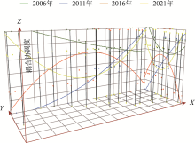
图6
河西走廊水资源-生态-经济系统耦合协调度全域分析"

| [1] | 张恬姿, 王小军, 齐广平, 等. 甘肃省水资源-经济社会-生态环境耦合协调驱动因素研究[J]. 水利水运工程学报, 2023(3): 38-46. |
| [Zhang Tianzi, Wang Xiaojun, Qi Guangping, et al. Driving factors of water resources-economic society-ecological environment coupling in Gansu Province[J]. Hydro-Science and Engineering, 2023(3): 38-46.] | |
| [2] | 吴青松, 马军霞, 左其亭, 等. 塔里木河流域水资源-经济社会-生态环境耦合系统和谐程度量化分析[J]. 水资源保护, 2021, 37(2): 55-62. |
| [Wu Qingsong, Ma Junxia, Zuo Qiting, et al. Quantitative analysis on harmony degree of water resources-economic society-ecological environment coupling system in the Tarim River Basin[J]. Water Resources Protection, 2021, 37(2): 55-62.] | |
| [3] | 刘科, 韩路, 范聪喆. 关中地区水资源-社会经济-生态系统耦合协调发展评价[J]. 水利建设与管理, 2023, 43(11): 6-12, 16. |
| [Liu Ke, Han Lu, Fan Congzhe. Assessment of the coordinated and coupling development of water resources, social economy and ecology system in Guanzhong region[J]. Water Conservancy Construction and Management, 2023, 43(11): 6-12, 16.] | |
| [4] | 袁汝华, 臧艳秋. 长江经济带经济发展与水资源环境耦合协调性实证分析[J]. 水利经济, 2021, 39(2): 1-8. |
| [Yuan Ruhua, Zang Yanqiu. Empirical analysis of coupling and coordination between economic development and water resource environment in Yangtze River Economic Belt[J]. Journal of Economics of Water Resources, 2021, 39(2): 1-8.] | |
| [5] | 王西琴, 何芬, 张兵. 丽江市经济发展与环境污染水平的关系[J]. 地理研究, 2010, 29(5): 927-934. |
| [Wang Xiqin, He Fen, Zhang Bing. Study on the relationship between economic growth and environmental degradation of Lijiang City[J]. Geographical Research, 2010, 29(5): 927-934.] | |
| [6] |
黄松, 李燕林, 李如友. 桂西地区地质遗迹与民族文化资源的空间关系及成因机理[J]. 地理学报, 2015, 70(9): 1434-1448.
doi: 10.11821/dlxb201509007 |
|
[Huang Song, Li Yanlin, Li Ruyou. Spatial relationship and formation mechanism of geological relics and ethnic cultural resources in western Guangxi, China[J]. Acta Geographica Sinica, 2015, 70(9): 1434-1448.]
doi: 10.11821/dlxb201509007 |
|
| [7] | 牟宇峰, 孙伟, 袁丰, 等. 长江三角洲地区产业演变的就业响应研究[J]. 地理与地理信息科学, 2013, 29(2): 60-65. |
| [Mu Yufeng, Sun Wei, Yuan Feng, et al. Research on employment response to industrial evolution in the Yangtze River Delta[J]. Geography and Geo-Information Science, 2013, 29(2): 60-65.] | |
| [8] | 谢保鹏, 陈英, 白志远, 等. 甘肃省县区单元城镇工矿用地与二三产业耦合状态的时空变化研究[J]. 干旱区资源与环境, 2013, 27(9): 18-25. |
| [Xie Baopeng, Chen Ying, Bai Zhiyuan, et al. Spatiotemporal changes of coupling between industrial land and secondary & service industries of Gansu’s counties[J]. Journal of Arid Land Resources and Environment, 2013, 27(9): 18-25.] | |
| [9] | 冯俊华, 张路路, 唐萌. 农业经济—生态—社会复合系统耦合协调发展研究——以陕西省为例[J]. 系统科学学报, 2021, 29(3): 92-96. |
| [Feng Junhua, Zhang Lulu, Tang Meng. Research on coupling coordination in Ecology-economy-society system: Taking Shaanxi Pro-vince as an example[J]. Journal of Systems Science, 2021, 29(3): 92-96.] | |
| [10] | Zhang Yu, Zhu Taoxing, Guo Haiyan, et al. Analysis of the coupling coordination degree of the Society-Economy-Resource-Environment system in urban areas: Case study of the Jingjingji urban agglomeration, China[J]. Ecological Indicators, 2023, 146: 109851. |
| [11] |
彭红松, 郭丽佳, 章锦河, 等. 区域经济增长与资源环境压力的关系研究进展[J]. 资源科学, 2020, 42(4): 593-606.
doi: 10.18402/resci.2020.04.01 |
|
[Peng Hongsong, Guo Lijia, Zhang Jinhe, et al. Research progress and implication of the relationship between regional economic growth and resource-environmental pressure[J]. Resources Science, 2020, 42(4): 593-606.]
doi: 10.18402/resci.2020.04.01 |
|
| [12] | 丛晓男. 耦合度模型的形式、性质及在地理学中的若干误用[J]. 经济地理, 2019, 39(4): 18-25. |
| [Cong Xiaonan. Expression and mathematical property of poupling model, and its misuse in geographical science[J]. Economic Geography, 2019, 39(4): 18-25.] | |
| [13] | 赵文智, 任珩, 杜军, 等. 河西走廊绿洲生态建设和农业发展的若干思考与建议[J]. 中国科学院院刊, 2023, 38(3): 424-434. |
| [Zhao Wenzhi, Ren Heng, Du Jun, et al. Thoughts and suggestions on oasis ecological construction and agricultural development in Hexi Corridor[J]. Bulletin of Chinese Academy of Sciences, 2023, 38(3): 424-434.] | |
| [14] |
王新源, 刘世增, 陈翔舜, 等. 河西走廊绿洲面积动态及其驱动因素[J]. 中国沙漠, 2019, 39(4): 212-219.
doi: 10.7522/j.issn.1000-694X.2019.00043 |
|
[Wang Xinyuan, Liu Shizeng, Chen Xiangshun, et al. Dynamic changes and driving factors of oasis in Hexi Corridor[J]. Journal of Desert Research, 2019, 39(4): 212-219.]
doi: 10.7522/j.issn.1000-694X.2019.00043 |
|
| [15] | 赵雪雁. 甘肃省经济发展与环境质量的交互耦合关系[J]. 干旱区资源与环境, 2008, 22(6): 1-7. |
| [Zhao Xueyan. Analysis on coupling relationship between economic development and environmental quality in Gansu[J]. Journal of Arid Land Resources and Environment, 2008, 22(6): 1-7.] | |
| [16] | 秦东丽, 陈屹德. 基于“PSR-EES”模型的江苏省旅游生态安全研究[J]. 南阳师范学院学报, 2019, 18(6): 10-16. |
| [Qin Dongli, Chen Yide. Research on Jiangsu Province tourism ecological security based on PSR-EES model[J]. Journal of Nanyang Normal University, 2019, 18(6): 10-16.] | |
| [17] |
王重玲, 韩莉, 朱志玲. 宁夏新型城镇化与人居环境发展时空耦合关系分析[J]. 中国农学通报, 2018, 34(26): 83-89.
doi: 10.11924/j.issn.1000-6850.casb17100066 |
|
[Wang Chongling, Han Li, Zhu Zhiling. Space-time coupling of new-type urbanization and human settlement development[J]. Chinese Agricultural Science Bulletin, 2018, 34(26): 83-89.]
doi: 10.11924/j.issn.1000-6850.casb17100066 |
|
| [18] | 白爱桃, 叶得明. 西北干旱区人口农业经济—生态耦合协调态势分析——以甘肃省民勤县为例[J]. 资源开发与市场, 2017, 33(1): 54-58. |
| [Bai Aitao, Ye Deming. Analysis of coupling coordination situation among population-agricultural Economy-Ecology in Northwest arid areas: Taking Minqin county of Gansu Province as an example[J]. Resource Development & Market, 2017, 33(1): 54-58.] | |
| [19] |
吴玥葶, 郭利丹, 井沛然, 等. 中亚五国水-能源-粮食-生态耦合关系及时空分异[J]. 干旱区研究, 2023, 40(4): 573-582.
doi: 10.13866/j.azr.2023.04.06 |
|
[Wu Yueting, Guo Lidan, Jing Peiran, et al. Coupling relationship and spatiotemporal differentiation of the water-energy-food-ecology nexus in five Central Asian countries[J]. Arid Zone Research, 2023, 40(4): 573-582.]
doi: 10.13866/j.azr.2023.04.06 |
|
| [20] |
王淑佳, 孔伟, 任亮, 等. 国内耦合协调度模型的误区及修正[J]. 自然资源学报, 2021, 36(3): 793-810.
doi: 10.31497/zrzyxb.20210319 |
|
[Wang Shujia, Kong Wei, Ren Liang, et al. Research on misuses and modification of coupling coordination degree model in China[J]. Journal of Natural Resources, 2021, 36(3): 793-810.]
doi: 10.31497/zrzyxb.20210319 |
|
| [21] | 张妍, 吴玉洁. 基于耦合模型的产业结构与生态环境的协调发展研究——以陕西省商洛市为例[J]. 湖北农业科学, 2021, 60(23): 196-200. |
| [Zhang Yan, Wu Yujie. Research on the coordinated development of industrial structure and ecological environment based on coupling model: Taking Shangluo City in Shaanxi Province as an example[J]. Hubei Agricultural Sciences, 2021, 60(23): 196-200.] | |
| [22] | 张玉春, 于鹏生, 任剑翔. 甘肃省产业结构与经济增长的灰色关联分析[J]. 中国管理信息化, 2011, 14(16): 55-57. |
| [Zhang Yuchun, Yu Pengsheng, Ren Jianxiang. Grey correlation analysis between industrial structure and economic growth in Gansu Province[J]. China Management Informationization, 2011, 14(16): 55-57.] | |
| [23] | 李岚, 樊瑞博, 谈存峰. 农业高质量发展时空演化与区域差异——基于甘肃省14市州的实证分析[J]. 云南农业大学学报(社会科学), 2024, 18(4): 52-58. |
| [Li Lan, Fan Ruibo, Tan Cunfeng. Temporal and spatial evolution and regional differences of high-quality agricultural development: Based on the empirical analysis of 14 cities in Gansu Province[J]. Journal of Yunnan Agricultural University (Social Science), 2024, 18(4): 52-58.] | |
| [24] | 陈述, 纪勤, 颜克胜, 等. 长江流域水资源—经济—生态系统的耦合协调及影响因素研究[J]. 水资源与水工程学报, 2023, 34(3): 28-36. |
| [Chen Shu, Ji Qin, Yan Kesheng, et al. Coupling coordination and influencing factors of water-economy-ecosystem in the Yangtze River Basin[J]. Journal of Water Resources & Water Engineering, 2023, 34(3): 28-36.] | |
| [25] | 陈亚宁, 李忠勤, 徐建华, 等. 中国西北干旱区水资源与生态环境变化及保护建议[J]. 中国科学院院刊, 2023, 38(3): 385-393. |
| [Chen Yaning, Li Zongqin, Xu Jianhua, et al. Changes and protection suggestions in water resources and ecological environment in arid region of Northwest China[J]. Bulletin of Chinese Academy of Sciences, 2023, 38(3): 385-393.] | |
| [26] | 黄晓楠, 张目. 中国省域生态文明建设与金融集聚耦合协调发展研究[J]. 林业经济, 2020, 42(4): 34-45. |
| [Huang Xiaonan, Zhang Mu. Study on the coupling coordinated development between China’s provincial ecological civilization construction and financial agglomeration[J]. Forestry Economics, 2020, 42(4): 34-45.] | |
| [27] | 董燕红, 钟定胜, 卢小丽. 主成分与层次分析法在区域可持续发展能力评价中的应用对比[J]. 安全与环境学报, 2016, 16(1): 359-365. |
| [Dong Yanhong, Zhong Dingsheng, Lu Xiaoli. Comparative study of the application of PCA and AHP to the analysis and evaluation of the regional sustainable development[J]. Journal of Safety and Environment, 2016, 16(1): 359-365.] | |
| [28] | 高泽阳, 常跟应. 中国干旱区城市经济社会与资源环境协调发展研究——以河西走廊5市为例[J]. 复旦学报(自然科学版), 2021, 60(4): 515-523. |
| [Gao Zeyang, Chang Genying. Research on the harmonious development of social economy, resources and environment in arid regions of China: A case study of 5 cities in Hexi Corridor[J]. Journal of Fudan University (Natural Science), 2021, 60(4): 515-523.] |
| [1] | 吴思源, 郝利娜. 2001—2021年黄河流域植被覆盖变化及其驱动因素[J]. 干旱区研究, 2024, 41(8): 1373-1384. |
| [2] | 杨晓玲, 周华, 陈静, 赵慧华, 吴雯. 河西走廊东部不同气候态气温变化及其对气候评价的影响[J]. 干旱区研究, 2024, 41(7): 1089-1098. |
| [3] | 雷菲亚, 李小双, 陶冶, 尹本丰, 荣晓莹, 张静, 陆永兴, 郭星, 周晓兵, 张元明. 西北干旱区藓类结皮覆盖下土壤多功能性特征及影响因子[J]. 干旱区研究, 2024, 41(5): 812-820. |
| [4] | 安宁, 郭彬, 张东梅, 杨淇越, 罗维成. 河西走廊中段荒漠植被组成及土壤养分空间分布特征[J]. 干旱区研究, 2024, 41(3): 432-443. |
| [5] | 刘一丹, 姚晓军, 李宗省, 胡家瑜. 气候变化和土地利用覆盖变化对河西地区植被净初级生产力的影响[J]. 干旱区研究, 2024, 41(1): 169-180. |
| [6] | 陈加伟, 褚建民, 甘红豪, 徐磊, 公帅, 刘浩, 王迎新, 杨洪晓, 徐晓庆, 齐丹卉. 浑善达克沙地长梗扁桃群丛特征及其驱动因素分析[J]. 干旱区研究, 2023, 40(5): 777-784. |
| [7] | 任丽雯, 王兴涛, 刘明春, 王大为. 石羊河流域植被净初级生产力时空变化及驱动因素[J]. 干旱区研究, 2023, 40(5): 818-828. |
| [8] | 马俊梅,马剑平,满多清,郭春秀,张裕年,赵鹏,王飞,李元星. 河西走廊天然胡杨林的分布和更新特征及其与土壤因子的关系[J]. 干旱区研究, 2023, 40(2): 224-234. |
| [9] | 尹明财,朱豪,胡圆昭,李振中,张济世. 甘肃省灰水足迹变化特征及驱动因素[J]. 干旱区研究, 2022, 39(6): 1810-1818. |
| [10] | 张昊琛,萨楚拉,孟凡浩,罗敏,王牧兰,高红豆. 内蒙古地表冻融指数动态变化与驱动因素分析[J]. 干旱区研究, 2022, 39(6): 1996-2008. |
| [11] | 姚佳,陈启慧,李琼芳,崔罡,张良憬. 伊犁河—巴尔喀什湖流域实际蒸散发时空变化特征及其环境影响因子[J]. 干旱区研究, 2022, 39(5): 1564-1575. |
| [12] | 冯强,赵文武,段宝玲. 生态系统服务权衡强度与供需匹配度的关联性分析——以山西省为例[J]. 干旱区研究, 2022, 39(4): 1222-1233. |
| [13] | 王晓峰,延雨,李月皓,张兴,符鑫鑫. 银川市湿地景观演变及其驱动因素[J]. 干旱区研究, 2021, 38(3): 855-866. |
| [14] | 邹磊,余江游,王飞宇,张彦. 渭河流域极端降水时空演变规律及其对大气环流因子的响应[J]. 干旱区研究, 2021, 38(3): 764-774. |
| [15] | 白壮壮, 崔建新, 丁晓辉. 1986—2015年鄂尔多斯高原沙漠化及其驱动因素研究[J]. 干旱区研究, 2020, 37(3): 749-. |
|
||