干旱区研究 ›› 2024, Vol. 41 ›› Issue (9): 1593-1604.doi: 10.13866/j.azr.2024.09.15 cstr: 32277.14.AZR.20240915
李可璇1( ), 张蕾2, 李豪2, 张恩月1, 李育桢1, 宋彩云1, 刘庚1()
收稿日期:2024-04-08
修回日期:2024-06-19
出版日期:2024-09-15
发布日期:2024-09-25
通讯作者:
刘庚. E-mail: liugeng9696@126.com作者简介:李可璇(1998-),女,硕士研究生,主要从事国土空间生态修复研究. E-mail: 1195797486@qq.com
基金资助:
LI Kexuan1(), ZHANG Lei2, LI Hao2, ZHANG Enyue1, LI Yuzhen1, SONG Caiyun1, LIU Geng1()
Received:2024-04-08
Revised:2024-06-19
Published:2024-09-15
Online:2024-09-25
摘要:
国土空间生态修复是落实国家生态文明战略的重要举措,生态修复关键区域识别是国土空间生态修复的关键一环,是科学开展生态修复的关键和难点,对维护区域生态安全具有重要的意义,但当前我国国土空间生态修复关键区域识别相关理论研究滞后于实践工作。本文以晋西北为研究区,通过形态学空间分析(Morphological Spatial Analysis,MSPA)模型结合生态系统服务价值识别生态源地,采用电路理论识别与提取生态廊道,在此基础上,进行生态修复关键区域识别及时空演变规律分析,从而给出对应生态修复策略。结果显示:2000—2020年晋西北生态源地数量及面积均呈现增加的趋势,20 a间生态源地总面积从1898.43 km2增长到2026.17 km2,空间分布呈现南部集中连片,北部零散分布的特点;生态廊道数量与长度先增加后减少,空间分布上南部保持短且密集,中部和北部由长且稀疏趋向短且密集。生态修复关键区域中,生态夹点面积总体下降,20 a间从262.89 km2下降至194.34 km2,夹点普遍分布于生态廊道的两端邻近生态源地的区域,主要分布在偏关县、平鲁区、神池县和朔城区;生态障碍点整体呈现增加趋势,20 a间从324.61 km2增长到504.72 km2,随后又减少到338.86 km2,障碍点普遍分布于生态廊道的中段,由聚集分布转变为均匀分布。研究综合生态修复关键区域时空演变特征及研究区生态本底,提出针对性生态修复策略,即加强夹点和障碍点的小流域、小区域治理,减少人为干扰,以期为区域国土空间生态修复工作提供参考。
李可璇, 张蕾, 李豪, 张恩月, 李育桢, 宋彩云, 刘庚. 基于MSPA模型和电路理论的晋西北国土空间生态修复关键区域识别[J]. 干旱区研究, 2024, 41(9): 1593-1604.
LI Kexuan, ZHANG Lei, LI Hao, ZHANG Enyue, LI Yuzhen, SONG Caiyun, LIU Geng. Identification of the key regions of spatial ecological restoration in the Northwest Shanxi based on the MSPA model and circuit theory[J]. Arid Zone Research, 2024, 41(9): 1593-1604.
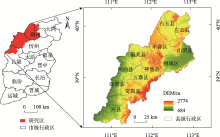
图1
研究区位置示意图"

表1
晋西北生态系统服务价值当量"
| 生态系统服务 | 耕地 | 林地 | 草地 | 水域 | 建设用地 | 未利用土地 | |
|---|---|---|---|---|---|---|---|
| 供给服务 | 食物生产 | 0.85 | 0.25 | 0.23 | 0.66 | 0.00 | 0.01 |
| 原料生产 | 0.40 | 0.58 | 0.34 | 0.37 | 0.00 | 0.03 | |
| 水资源供给 | 0.02 | 0.30 | 0.19 | 5.44 | 0.00 | 0.02 | |
| 调节服务 | 气体调节 | 0.67 | 1.91 | 1.21 | 1.34 | 0.00 | 0.11 |
| 气候调节 | 0.36 | 5.71 | 3.19 | 2.95 | 0.00 | 0.10 | |
| 净化环境 | 0.10 | 1.67 | 1.05 | 4.58 | 0.00 | 0.31 | |
| 水文调节 | 0.27 | 3.74 | 2.34 | 63.24 | 0.00 | 0.21 | |
| 支持服务 | 土壤保持 | 1.03 | 2.32 | 1.47 | 1.62 | 0.00 | 0.13 |
| 维持养分循环 | 0.12 | 0.18 | 0.11 | 0.13 | 0.00 | 0.01 | |
| 生物多样性 | 0.13 | 2.12 | 1.34 | 5.21 | 0.00 | 0.12 | |
| 文化服务 | 美学景观 | 0.06 | 0.93 | 0.59 | 3.31 | 0.00 | 0.05 |
表2
阻力因素赋值"
| 阻力因子 | 1级 | 2级 | 3级 | 4级 | 5级 | 权重 |
|---|---|---|---|---|---|---|
| 高程/m | <1100 | 1100~1300 | 1300~1500 | 1500~1700 | >1700 | 0.08 |
| 坡度/(°) | 0~2 | 2~6 | 6~15 | 15~25 | >25 | 0.07 |
| 土地利用类型 | 林地、水域 | 草地 | 耕地 | 未利用土地 | 建设用地 | 0.23 |
| NDVI | >0.8 | 0.6~0.8 | 0.4~0.6 | 0.2~0.4 | <0.2 | 0.22 |
| 距道路距离/m | >4000 | 3000~4000 | 2000~3000 | 1000~2000 | 0~1000 | 0.12 |
| 距居民点距离/m | >2000 | 1500~2000 | 1000~1500 | 500~1000 | <500 | 0.09 |
| 距水体距离/m | <1000 | 1000~2000 | 2000~3000 | 3000~4000 | >4000 | 0.19 |
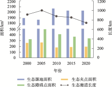
图2
2000—2020年晋西北源地、夹点、障碍点面积与廊道长度变化趋势"

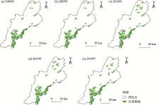
图3
2000—2020年晋西北生态源地"

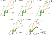
图4
2000—2020年晋西北生态廊道"

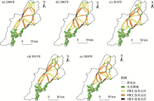
图5
2000—2020年晋西北生态夹点"

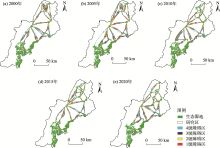
图6
2000—2020年晋西北生态障碍点"

| [1] | 曹宇, 王嘉怡, 李国煜. 国土空间生态修复: 概念思辨与理论认知[J]. 中国土地科学, 2019, 33(7): 1-10. |
| [Cao Yu, Wang Jiayi, Li Guoyu. Ecological restoration for territorial space: Basic concepts and foundations[J]. China Land Science, 2019, 33(7): 1-10.] | |
| [2] | 傅伯杰. 国土空间生态修复亟待把握的几个要点[J]. 中国科学院院刊, 2021, 36(1): 64-69. |
| [Fu Bojie. Several key points in territorial ecological restoration[J]. Bulletin of Chinese Academy of Sciences, 2021, 36(1): 64-69.] | |
| [3] |
白中科. 国土空间生态修复若干重大问题研究[J]. 地学前缘, 2021, 28(4): 1-13.
doi: 10.13745/j.esf.sf.2021.6.20 |
|
[Bai Zhongke. The major issues in ecological restoration of China’s territorial space[J]. Earth Science Frontiers, 2021, 28(4): 1-13.]
doi: 10.13745/j.esf.sf.2021.6.20 |
|
| [4] |
彭建, 赵会娟, 刘焱序, 等. 区域生态安全格局构建研究进展与展望[J]. 地理研究, 2017, 36(3): 407-419.
doi: 10.11821/dlyj201703001 |
| [Peng Jian, Zhao Huijuan, Liu Yanxu, et al. Research progress and prospect on regional ecological security pattern construction[J]. Geographical Research, 2017, 36(3): 407-419.] | |
| [5] | 潘竟虎, 刘晓. 基于空间主成分和最小累积阻力模型的内陆河景观生态安全评价与格局优化——以张掖市甘州区为例[J]. 应用生态学报, 2015, 26(10): 3126-3136. |
|
[Pan Jinghu, Liu Xiao. Assessment of landscape ecological security and optimization of landscape pattern based onspatial principal component analysis and resistance model in arid inland area: A case study of Ganzhou District, Zhangye City, Northwest China[J]. Chinese Journal of Applied Ecology, 2015, 26(10): 3126-3136.]
pmid: 26995922 |
|
| [6] |
包玉斌, 王耀宗, 路锋, 等. 六盘山区国土空间生态安全格局构建与分区优化[J]. 干旱区研究, 2023, 40(7): 1172-1183.
doi: 10.13866/j.azr.2023.07.14 |
|
[Bao Yubin, Wang Yaozong, Lu Feng, et al. Construction of an ecological security pattern and zoning optimization for territorial space in the Liupan Mountain Area[J]. Arid Zone Research, 2023, 40(7): 1172-1183.]
doi: 10.13866/j.azr.2023.07.14 |
|
| [7] | 李权荃, 金晓斌, 张晓琳, 等. 基于景观生态学原理的生态网络构建方法比较与评价[J]. 生态学报, 2023, 43(4): 1461-1473. |
| [Li Quanquan, Jin Xiaobin, Zhang Xiaolin, et al. Comparison and evaluation of the ecological network construction method based on principles of landscape ecology[J]. Acta Ecologica Sinica, 2023, 43(4): 1461-1473.] | |
| [8] | 马晓琳, 郭莎莎, 徐扬, 等. 生态脆弱区生态安全格局构建研究[J]. 生态学报, 2023, 43(22): 9500-9513. |
| [Ma Xiaolin, Guo Shasha, Xu Yang, et al. Research on ecological security pattern construction in vulnerable ecological region[J]. Acta Ecologica Sinica, 2023, 43(22): 9500-9513.] | |
| [9] | 郑群明, 扈嘉辉, 申明智. 基于MSPA和MCR模型的湖南省生态网络构建[J]. 湖南师范大学自然科学学报, 2021, 44(5): 1-10. |
| [Zheng Qunming, Hu Jiahui, Shen Mingzhi. Construction of ecological network in Hunan Province based on MSPA and MCR Models[J]. Journal of Natural Science of Hunan Normal University, 2021, 44(5): 1-10.] | |
| [10] | Liu H L, Wang Z L, Zhang L P, et al. Construction of an ecological security network in the Fenhe River Basin and its temporal and spatial evolution characteristics[J]. Journal of Cleaner Production, 2023, 417: 137961. |
| [11] | 覃彬桂, 林伊琳, 赵俊三, 等. 基于InVEST模型和电路理论的昆明市国土空间生态修复关键区域识别[J]. 中国环境科学, 2023, 43(2): 809-820. |
| [Qin Bingui, Lin Yilin, Zhao Junsan, et al. Identification of key areas for the ecological restoration of territorial space in Kunming based on the InVEST model and circuit theory[J]. China Environmental Science, 2023, 43(2): 809-820.] | |
| [12] | 李倩瑜, 唐立娜, 邱全毅, 等. 基于形态学空间格局分析和最小累积阻力模型的城市生态安全格局构建——以厦门市为例[J]. 生态学报, 2024, 44(6): 2284-2294. |
| [Li Qianyu, Tang Lina, Qiu Quanyi, et al. Construction of urban ecological security pattern based on MSPA and MCR Model: A case study of Xiamen[J]. Acta Ecologica Sinica, 2024, 44(6): 2284-2294.] | |
| [13] | Vogt P, Riitters K H, Iwanowski M, et al. Mapping landscape corridors[J]. Ecological Indicators, 2007, 7(2): 481-488. |
| [14] | 朱琪, 袁泉, 于大炮, 等. 基于电路理论的东北森林带生态安全网络构建[J]. 生态学杂志, 2021, 40(11): 3463-3473. |
|
[Zhu Qi, Yuan Quan, Yu Dapao, et al. Construction of ecological security network of Northeast China forest belt based on the circuit theory[J]. Chinese Journal of Ecology, 2021, 40(11): 3463-3473.]
doi: DOI: 10.13292/j.1000-4890.202111.012 |
|
| [15] | 曹秀凤, 刘兆顺, 李淑杰, 等. 基于生态安全格局的国土空间生态修复关键区域识别——以吉林省松原市为例[J]. 中国环境科学, 2022, 42(6): 2779-2787. |
| [Cao Xiufeng, Liu Zhaoshun, Li Shujie, et al. Identification of key areas of ecological protection and restoration based on the pattern of ecological security: A case of Songyuan City, Jilin Province[J]. China Environmental Science, 2022, 42(6): 2779-2787.] | |
| [16] | Yang Y, Chen J J, Huang R J, et al. Construction of ecological security pattern based on the importance of ecological protection: A case study of Guangxi, a Karst Region in China[J]. International Journal of Environmental Research and Public Health, 2022, 19(9): 5699-5699. |
| [17] | 刘春飞, 刘平辉, 朱传民. 基于电路理论的生态安全格局构建的生态以赣州市为例[J]. 湖北农业科学, 2022, 61(23): 30-37. |
| [Liu Chunfei, Liu Pinghui, Zhu Chuanmin. Construction of ecological security pattern based on circuit theory: A case study of Ganzhou City[J]. Hubei Agricultural Sciences, 2022, 61(23): 30-37.] | |
| [18] | Fisher G, Velthuizen H V, Shah M, et al. Global agroecological assessment for agriculture in the 21st Century: Methodology and results[J]. Journal of Hunan Vocation-technical Teachers College, 2002, 11(8): 371-374. |
| [19] | 张玥, 许端阳, 李霞, 等. 中-老交通走廊核心区生态廊道构建与关键节点识别[J]. 生态学报, 2020, 40(6): 1933-1943. |
| [Zhang Yue, Xu Duanyang, Li Xia, et al. Construction of ecological corridors and identification of key nodes in the core area of China-Laos transportation corridors[J]. Acta Ecologica Sinica, 2020, 40(6): 1933-1943.] | |
| [20] |
彭建, 李慧蕾, 刘焱序, 等. 雄安新区生态安全格局识别与优化策略[J]. 地理学报, 2018, 73(4): 701-710.
doi: 10.11821/dlxb201804009 |
| [Peng Jian, Li Huilei, Liu Yanxu, et al. Identification and optimization of ecological security pattern in Xiong’an New Area[J]. Acta Geographica Sinica, 2018, 73(4): 701-710.] | |
| [21] | 程纪元. 基于生态网络的长治市矿区生态修复策略研究[D]. 北京: 中国地质大学, 2021. |
| [Cheng Jiyuan. Research on Ecological Restoration Strategies of Mining Areas in Changzhi Area Based on Ecological Network[D]. Beijing: China University of Geosciences, 2021.] | |
| [22] | 刘凤莲, 刘艳. 基于生态安全格局的高原城市生态修复关键区域识别——以昆明市为例[J]. 国土资源科技管理, 2023, 40(3): 17-30. |
| [Liu Fenglian, Liu Yan. Identification of key areas for ecological restoration in plateau cities based on the ecological security pattern: A case study of Kunming[J]. Scientific and Technological Management of Land and Resources, 2023, 40(3): 17-30.] | |
| [23] | 向爱盟, 岳启发, 赵筱青, 等. 西南喀斯特山区国土空间生态修复关键区识别及修复分区——以开远市为例[J]. 中国环境科学, 2023, 43(12): 6571-6582. |
| [Xiang Aimeng, Yue Qifa, Zhao Xiaoqing, et al. Identification and restoration zoning of key areas for ecological restoration of territorial space in southwestern karst mountainous areas: A case study of Kaiyuan City, China[J]. China Environmental Science, 2023, 43(12): 6571-6582.] | |
| [24] | 薛强, 路路, 牛韧, 等. 基于地质灾害敏感性的生态安全格局关键区识别与修复——以济南市为例[J]. 生态学报, 2021, 41(22): 9050-9063. |
| [Xue Qiang, Lu Lu, Niu Ren, et al. Identification and restoration of key areas of ecological security pattern based on sensitivity to geological disasters: A case study of Jinan City[J]. Acta Ecologica Sinica, 2021, 41(22): 9050-9063.] | |
| [25] | 古雄. 基于生态网络构建的县域国土空间生态保护与修复策略研究[D]. 南昌: 江西财经大学, 2022. |
| [Gu Xiong. Research on Ecological Protection and Restoration Strategy of County Territorial Space Based on Ecological Network Construction: A Case Study of Taihe County, Jiangxi Province[D]. Nanchang: Jiangxi University of Finance and Economics, 2022.] | |
| [26] | 温雪静, 周智, 张美丽, 等. 太行山区国土空间生态修复关键区域识别——以唐县为例[J]. 中国生态农业学报(中英文), 2021, 29(12): 2093-2106. |
| [Wen Xuejing, Zhou Zhi, Zhang Meili, et al. Identification of key areas of territorial ecological restoration in Taihang Mountains: A case study of Tang County[J]. Chinese Journal of Eco-Agriculture, 2021, 29(12): 2093-2106.] | |
| [27] | 张美丽, 李智, 张益琛, 等. 基于生态安全格局的国土空间生态修复关键区域识别——以河北省阜平县为例[J]. 水土保持研究, 2021, 28(3): 299-307, 3. |
| [Zhang Meili, Li Zhi, Zhang Yichen, et al. Identification of key areas of ecological restoration of land and space based on ecological security pattern: Take Fuping County in Hebei Province as example[J]. Research of Soil and Water Conservation, 2021, 28(3): 299-307, 3.] | |
| [28] |
付扬军, 师学义. 基于小流域尺度的县域国土空间生态修复分区——以山西汾河上游为例[J]. 自然资源学报, 2023, 38(5): 1225-1239.
doi: 10.31497/zrzyxb.20230508 |
|
[Fu Yangjun, Shi Xueyi. Ecological restoration zoning of county-level territorial space based on small watershed scale: A case study of the upper Fenhe River in Shanxi[J]. Journal of Natural Resources, 2023, 38(5): 1225-1239.]
doi: 10.31497/zrzyxb.20230508 |
|
| [29] |
孙茂森, 王让会, 宁虎森. 阿克苏河流域生态网络构建[J]. 干旱区研究, 2023, 40(9): 1509-1516.
doi: 10.13866/j.azr.2023.09.14 |
|
[Sun Maosen, Wang Ranghui, Ning Husen. Construction of the ecological network in the Aksu River Basin[J]. Arid Zone Research, 2023, 40(9): 1509-1516.]
doi: 10.13866/j.azr.2023.09.14 |
|
| [30] | 郑群明, 申明智, 钟林生. 普达措国家公园生态安全格局构建[J]. 生态学报, 2021, 41(3): 874-885. |
| [Zheng Qunming, Shen Mingzhi, Zhong Linsheng. Construction of ecological security pattern in Pudacuo National Park[J]. Acta Ecologica Sinica, 2021, 41(3) : 874-885.] | |
| [31] | 祁强强, 徐占军. 生态安全格局时空演变分析——以太原城市群为例[J]. 中国环境科学, 2023, 43(11): 5987-5997. |
| [Qi Qiangqiang, Xu Zhanjun. Analysis on the spatio-temporal evolution of ecological security patterns: A case study over Taiyuan Urban Agglomeration[J]. China Environmental Science, 2023, 43(11): 5987-5997.] | |
| [32] | 张海铃, 叶长盛, 胡梦姗. 基于生态安全格局的环鄱阳湖城市群生态修复关键区域识别及修复策略[J]. 水土保持研究, 2023, 30(2): 393-402. |
| [Zhang Hailing, Ye Changsheng, Hu Mengshan. Identification and restoration strategy of key areas of ecological restoration in urban agglomeration around Poyang Lake based on ecological security pattern[J]. Research of Soil and Water Conservation, 2023, 30(2): 393-402.] | |
| [33] | 朱东红. 晋西北地区生态环境质量评价研究[D]. 太原: 山西大学, 2003. |
| [Zhu Donghong. The Study of Assessment on the Eco-environment Quality of the Northwestern Region in Shanxi Province[D]. Taiyuan: Shanxi University, 2003.] | |
| [34] | 薛占金, 秦作栋, 程芳琴. 晋西北地区土地沙漠化时空格局及其驱动因素[J]. 中国环境科学, 2020, 40(12): 5428-5435. |
| [Xue Zhanjin, Qin Zuodong, Cheng Fangqin. Spatial-temporal patterns and driving factors of aeolian desertification in Northwest Shanxi Province[J]. China Environmental Science, 2020, 40(12): 5428-5435.] | |
| [35] | 谢高地, 张彩霞, 张雷明, 等. 基于单位面积价值当量因子的生态系统服务价值化方法改进[J]. 自然资源学报, 2015, 30(8): 1243-1254. |
|
[Xie Gaodi, Zhang Caixia, Zhang Leiming, et al. Improvement of the evaluation method for ecosystem service value based on per unit area[J]. Journal of Natural Resources, 2015, 30(8): 1243-1254.]
doi: 10.11849/zrzyxb.2015.08.001 |
|
| [36] |
宋利利, 秦明周. 整合电路理论的生态廊道及其重要性识别[J]. 应用生态学报, 2016, 27(10): 3344-3352.
doi: 10.13287/j.1001-9332.201610.035 |
|
[Song Lili, Qin Mingzhou. Identification of ecological corridors and its importance by integrating circuit theory[J]. Chinese Journal of Applied Ecology, 2016, 27(10): 3344-3352.]
doi: 10.13287/j.1001-9332.201610.035 |
|
| [37] | Brad H McRae, Sonia A Hall, Paul Beier, et al. Where to restore ecological connectivity? Detecting barriers and quantifying restoration benefits[J]. PLoS ONE, 2012, 7(12): e52604. |
| [38] | 杨园园. 晋西北生态脆弱区土地生态安全评价及影响因素研究[D]. 太原: 山西财经大学, 2023. |
| [Yang Yuanyuan. Evaluation and Influencling Factors of Land Ecological Security in Ecologically Fragile Area of Northwest Shanxi[D]. Taiyuan: Shanxi University of Finance and Economics, 2023.] |
| [1] | 张文睿, 孙栋元, 王亦可, 杨俊, 兰立军, 靳虎甲, 徐裕. 河西走廊水资源-生态环境-社会经济系统耦合关系及时空分异[J]. 干旱区研究, 2024, 41(9): 1527-1537. |
| [2] | 高鹏程, 岳艳妮, 鄢继选, 王世杰, 别强. 甘南藏族自治州土地利用与生态风险时空演变及驱动因素[J]. 干旱区研究, 2024, 41(7): 1140-1152. |
| [3] | 菅政博, 罗浩, 单娜娜. “双碳”目标下新疆“三生”空间时空演变特征及碳效应[J]. 干旱区研究, 2024, 41(7): 1238-1248. |
| [4] | 蔡玉琴, 祁栋林, 王烈福, 李海凤, 张德琴. 青海省不同等级寒冷日数时空演变特征[J]. 干旱区研究, 2024, 41(5): 742-752. |
| [5] | 高雅玉, 宋玉, 赵廷红, 高金芳, 何文博, 李泽霞. 马莲河下游产水量时空演变特征[J]. 干旱区研究, 2024, 41(5): 776-787. |
| [6] | 李文秀, 燕振刚. 基于地理探测器的甘肃农牧交错带土地利用时空演化及其驱动机制[J]. 干旱区研究, 2024, 41(4): 590-602. |
| [7] | 陶际峰, 包玉龙, 郭恩亮, 金额尔德木吐, 呼斯乐, 包玉海. 近40 a内蒙古冬旱时空演变特征[J]. 干旱区研究, 2024, 41(3): 387-398. |
| [8] | 包玉斌,王耀宗,路锋,刘自增,马大为,杨勇,吴娟,张永康. 六盘山区国土空间生态安全格局构建与分区优化[J]. 干旱区研究, 2023, 40(7): 1172-1183. |
| [9] | 邹易, 蒙吉军. 干旱区绿洲-城镇-荒漠景观演变及生态环境效应[J]. 干旱区研究, 2023, 40(6): 988-1001. |
| [10] | 吴玥葶, 郭利丹, 井沛然, 黄峰, 王浩轩. 中亚五国水-能源-粮食-生态耦合关系及时空分异[J]. 干旱区研究, 2023, 40(4): 573-582. |
| [11] | 王鹏, 秦思彤, 胡慧蓉. 近30 a拉萨河流域土地利用变化和生境质量的时空演变特征[J]. 干旱区研究, 2023, 40(3): 492-503. |
| [12] | 黄莹, 王素艳, 马阳, 王岱, 张雯, 王璠. 宁夏近60 a寒潮变化特征及其环流异常[J]. 干旱区研究, 2023, 40(11): 1718-1728. |
| [13] | 党慧, 荣丽华, 李伊彤, 赵名君. 农牧交错区三生空间时空演变特征与影响因素——以内蒙古呼和浩特市为例[J]. 干旱区研究, 2023, 40(10): 1698-1706. |
| [14] | 张志高, 孙梓欣, 张秀丽, 郭可欣, 李卓娅, 郝海姣, 蔡茂堂. 1960—2020年黄河流域气候生长季时空演变及成因分析[J]. 干旱区研究, 2023, 40(10): 1537-1546. |
| [15] | 侯青青,陈英,裴婷婷,吉珍霞,谢保鹏. 近25 a来甘肃省耕地资源时空变化及其影响因子[J]. 干旱区研究, 2022, 39(3): 955-967. |
|
||