干旱区研究 ›› 2022, Vol. 39 ›› Issue (3): 955-967.doi: 10.13866/j.azr.2022.03.29
侯青青1( ),陈英1,2(),裴婷婷2,吉珍霞3,谢保鹏2
收稿日期:2021-10-09
修回日期:2022-01-18
出版日期:2022-05-15
发布日期:2022-05-30
通讯作者:
陈英
作者简介:侯青青(1996-),女,博士研究生,主要从事生态遥感研究. E-mail: 基金资助:
HOU Qingqing1(),CHEN Ying1,2(),PEI Tingting2,JI Zhenxia3,XIE Baopeng2
Received:2021-10-09
Revised:2022-01-18
Online:2022-05-15
Published:2022-05-30
Contact:
Ying CHEN
摘要:
研究耕地资源时空变化及驱动因子,对于提高区域粮食安全,严守耕地保护红线,制定耕地保护政策和措施具有重要的实践意义。以甘肃省1995年、2005年、2015年和2020年4期土地利用数据为基础,在ArcGIS和GeoDa等技术的支持下,从栅格、格网和县域尺度全面分析了甘肃省近25 a耕地时空变化特征,并利用地理探测器对引起耕地变化的主要驱动因子进行了探测。结果表明:(1) 甘肃省1995—2020年间耕地减少幅度达1.6%,1995—2005年耕地面积增加,2005—2020年耕地面积递减,且耕地主要流向草地、林地和建设用地,而未利用地主要向耕地和草地转移。(2) 耕地空间分布呈“东南多、西北少”的典型特征。耕地空间分布受自然因素和社会经济因素的共同作用,其中,人口和土地开发强度的交互作用是1995年、2005年和2015年甘肃省耕地空间分布差异性的主要原因,而2020年温度和降水的交互作用成为影响耕地的主导因素。研究结果可为甘肃省耕地保护管理提供科学依据。
侯青青,陈英,裴婷婷,吉珍霞,谢保鹏. 近25 a来甘肃省耕地资源时空变化及其影响因子[J]. 干旱区研究, 2022, 39(3): 955-967.
HOU Qingqing,CHEN Ying,PEI Tingting,JI Zhenxia,XIE Baopeng. Analysis of cultivated land’s spatio-temporal changes and influencing factors in Gansu Province in recent 25 years[J]. Arid Zone Research, 2022, 39(3): 955-967.

图1
甘肃省示意图 注:底图采用自然资源部标准地图制图,审图号为GS(2019)3333号,对底图边界无修改。下同。"
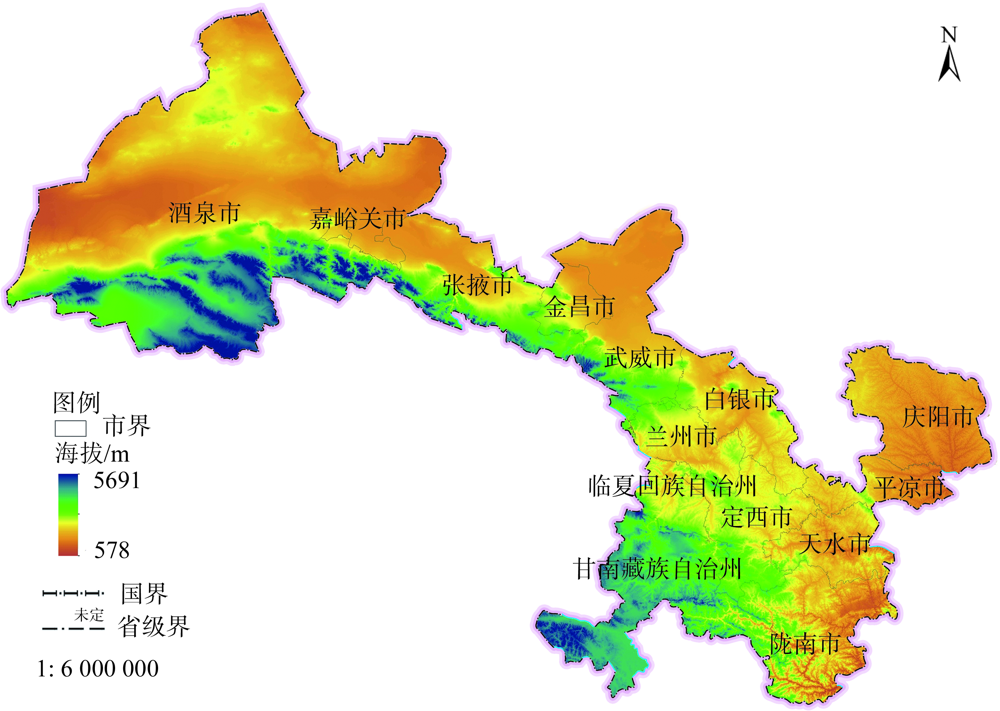
表1
1995—2005年甘肃省土地利用转移矩阵"
| 土地利用类型 | 耕地 | 林地 | 草地 | 水域 | 建设用地 | 未利用地 | 1995年总计 | 年净增长面积 |
|---|---|---|---|---|---|---|---|---|
| 耕地 | 36093.75 | 2865.50 | 22104.25 | 531.50 | 1915.00 | 1533.75 | 65043.75 | 39.25 |
| 林地 | 2731.00 | 22246.50 | 11534.25 | 114.75 | 133.75 | 804.25 | 37564.50 | 61.45 |
| 草地 | 22102.75 | 11949.50 | 92764.75 | 642.00 | 738.75 | 14749.50 | 142947.25 | -20.03 |
| 水域 | 580.25 | 86.75 | 629.25 | 1205.75 | 59.75 | 832.00 | 3393.75 | -5.05 |
| 建设用地 | 1705.75 | 108.75 | 703.50 | 54.50 | 741.00 | 113.50 | 3427.00 | 32.80 |
| 未利用地 | 2222.75 | 922.00 | 15011.00 | 794.75 | 166.75 | 152572.25 | 171689.50 | -108.43 |
| 2005年总计 | 65436.25 | 38179.00 | 142747.00 | 3343.25 | 3755.00 | 170605.25 | 424065.75 | 0.00 |
表2
2005—2020年甘肃省土地利用转移矩阵"
| 土地利用类型 | 耕地 | 林地 | 草地 | 水域 | 建设用地 | 未利用地 | 2005年总计 | 年净增长面积 |
|---|---|---|---|---|---|---|---|---|
| 耕地 | 33352.25 | 3235.00 | 23833.25 | 604.00 | 2552.75 | 1864.75 | 65436.25 | -96.85 |
| 林地 | 3025.25 | 20947.25 | 12967.75 | 142.00 | 220.50 | 922.75 | 38179.00 | 12.95 |
| 草地 | 22717.00 | 12926.50 | 88461.75 | 754.25 | 1330.50 | 16541.75 | 142747.00 | 30.67 |
| 水域 | 564.50 | 98.75 | 707.75 | 1092.75 | 81.75 | 800.50 | 3343.25 | 29.60 |
| 建设用地 | 1788.50 | 135.00 | 863.00 | 79.00 | 745.50 | 144.25 | 3755.00 | 119.10 |
| 未利用地 | 2536.00 | 1030.75 | 16373.50 | 1115.25 | 610.50 | 148939.25 | 170605.25 | -92.80 |
| 2020年总计 | 63983.50 | 38373.25 | 143207.00 | 3787.25 | 5541.50 | 169213.25 | 424065.75 | 0.00 |
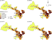
图2
1995—2020年甘肃省耕地核密度分布"


图3
1995—2020年甘肃省耕地面积空间分布"

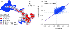
图4
甘肃省2020年耕地面积LISA聚集图和Moran散点图 注:括号内数字代表格网数量。"


图5
1995—2020年甘肃省县域耕地变化动态度空间分布格局"
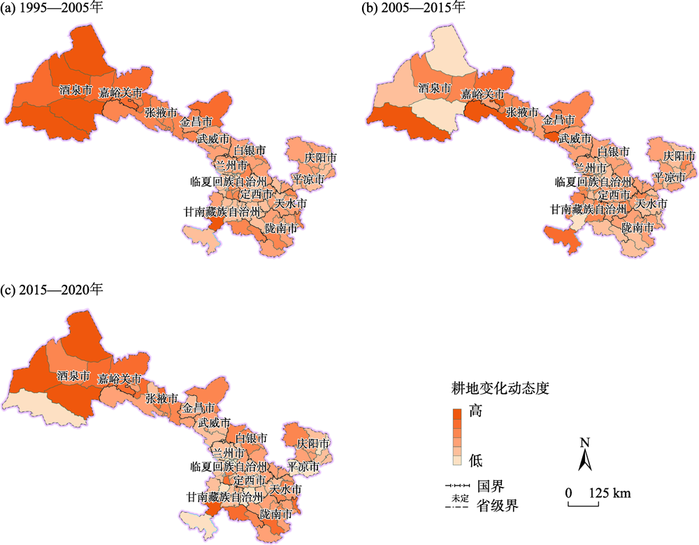
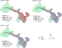
图6
1995—2020年甘肃省县域耕地变化动态度空间分布格局 注: 括号内数字代表格网数量。"

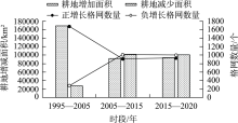
图7
甘肃省1995—2020年间3个时段耕地增减"
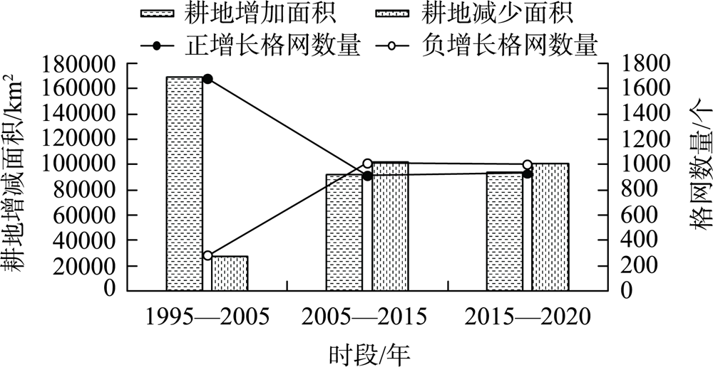
表3
1995年、2005年、2015年和2020年甘肃省地理探测器变量和指标"
| 驱动因子 | 分级 | 1995年 | 2005年 | 2015年 | 2020年 | |||||||
|---|---|---|---|---|---|---|---|---|---|---|---|---|
| q值 | P值 | q值 | P值 | q值 | P值 | q值 | P值 | |||||
| 人口(X1) | 6 | 0.45 | 0 | 0.16 | 0 | 0.41 | 0 | 0.39 | 0 | |||
| GDP(X2) | 6 | 0.29 | 0 | 0.14 | 0 | 0.38 | 0 | 0.38 | 0 | |||
| 土地开发强度(X3) | 6 | 0.42 | 0 | 0.17 | 0 | 0.40 | 0 | 0.07 | 0 | |||
| 降水(X4) | 6 | 0.37 | 0 | 0.10 | 0 | 0.26 | 0 | 0.36 | 0 | |||
| 温度(X5) | 6 | 0.14 | 0 | 0.05 | 0 | 0.12 | 0 | 0.13 | 0 | |||
| 坡度(X6) | 6 | 0.01 | 0 | 0.01 | 0 | 0.01 | 0 | 0.01 | 0 | |||
表4
1995年、2005年、2015年和2020年甘肃省各因子交互作用"
| 人口(X1) | GDP(X2) | 土地开发强度(X3) | 降水(X4) | 温度(X5) | 坡度(X6) | ||
|---|---|---|---|---|---|---|---|
| 1995年 | 人口(X1) | 0.45 | |||||
| GDP(X2) | 0.51 | 0.29 | |||||
| 土地开发强度(X3) | 0.61 | 0.53 | 0.42 | ||||
| 降水(X4) | 0.52 | 0.46 | 0.58 | 0.37 | |||
| 温度(X5) | 0.50 | 0.41 | 0.48 | 0.54 | 0.14 | ||
| 坡度(X6) | 0.46 | 0.30 | 0.43 | 0.39 | 0.16 | 0.01 | |
| 2005年 | 人口(X1) | 0.16 | |||||
| GDP(X2) | 0.21 | 0.14 | |||||
| 土地开发强度(X3) | 0.24 | 0.24 | 0.17 | ||||
| 降水(X4) | 0.19 | 0.18 | 0.22 | 0.10 | |||
| 温度(X5) | 0.19 | 0.17 | 0.19 | 0.19 | 0.05 | ||
| 坡度(X6) | 0.17 | 0.15 | 0.18 | 0.12 | 0.06 | 0.01 | |
| 2015年 | 人口(X1) | 0.40 | |||||
| GDP(X2) | 0.49 | 0.38 | |||||
| 土地开发强度(X3) | 0.57 | 0.58 | 0.40 | ||||
| 降水(X4) | 0.47 | 0.48 | 0.51 | 0.26 | |||
| 温度(X5) | 0.47 | 0.46 | 0.45 | 0.52 | 0.12 | ||
| 坡度(X6) | 0.41 | 0.39 | 0.41 | 0.28 | 0.14 | 0.01 | |
| 2020年 | 人口(X1) | 0.39 | |||||
| GDP(X2) | 0.48 | 0.38 | |||||
| 土地开发强度(X3) | 0.41 | 0.41 | 0.07 | ||||
| 降水(X4) | 0.47 | 0.46 | 0.38 | 0.36 | |||
| 温度(X5) | 0.45 | 0.45 | 0.22 | 0.52 | 0.13 | ||
| 坡度(X6) | 0.39 | 0.39 | 0.08 | 0.37 | 0.15 | 0.01 |
| [1] | 陈百明, 王秀芬. 耕地质量建设的生态与环境理念[J]. 中国农业资源与区划, 2013, 34(1): 1-4. |
| [ Chen Baiming, Wang Xiufen. Ecological and environmental idea of cultivated land quality construction[J]. Chinese Journal of Agricultural Resources and Regional Planning, 2013, 34(1): 1-4. ] | |
| [2] | 杨桂山. 长江三角洲近50年耕地数量变化的过程与驱动机制研究[J]. 自然资源学报, 2001, 16(2): 121-127. |
| [ Yang Guishan. The process and driving forces of change in arable-land area in the Yangtze River Delta during the past 50 years[J]. Journal of Natural Resources, 2001, 16(2): 121-127. ] | |
| [3] | 赵晓丽, 张增祥, 汪潇, 等. 中国近30 a耕地变化时空特征及其主要原因分析[J]. 农业工程学报, 2014, 30(3): 1-11. |
| [ Zhao Xiaoli, Zhang Zengxiang, Wang Xiao, et al. Analysis of Chinese cultivated land’s spatial-temporal changes and causes in recent 30 years[J]. Transactions of the Chinese Society of Agricultural Engineering, 2014, 30(3): 1-11. ] | |
| [4] | 周润芳, 孙建国, 张卓. 甘肃省榆中县地形对耕地分布影响[J]. 遥感信息, 2020, 35(4): 148-154. |
| [ Zhou Runfang, Sun Jianguo, Zhang Zhuo. Effects of topographic on cultivated land distribution in Yushong County of Gansu Province[J]. Remote Sensing Information, 2020, 35(4): 148-154. ] | |
| [5] | 关兴良, 方创琳, 鲁莎莎. 中国耕地变化的空间格局与重心曲线动态分析[J]. 自然资源学报, 2010, 25(12): 1997-2006. |
| [ Guan Xingliang, Fang Chuanglin, Lu Shasha. Analysis of spatial distribution and gravity centers curve dynamic cultivated land changes in China[J]. Journal of Natural Resources, 2010, 25(12): 1997-2006. ] | |
| [6] | 袁承程, 张定祥, 刘黎明, 等. 近10年中国耕地变化的区域特征及演变态势[J]. 农业工程学报, 2021, 37(1): 267-278. |
| [ Yuan Chengcheng, Zhang Dingxiang, Liu Liming, et al. Regional characteristics and spatial-temporal distribution of cultivated land change in China during 2009-2018[J]. Transactions of the Chinese Society of Agricultural Engineering, 2021, 37(1): 267-278. ] | |
| [7] | 陈正发, 史东梅, 何伟, 等. 基于 “要素-需求-调控” 的云南坡耕地质量评价[J]. 农业工程学报, 2020, 36(12): 236-246. |
| [ Chen Zhengfa, Shi Dongmei, He Wei, et al. Quality evaluation of slope farmland in Yunnan Province based on “element-demand-regulation” framework[J]. Transactions of the Chinese Society of Agricultural Engineering, 2020, 36(12): 236-246. ] | |
| [8] | 张扬, 周忠发, 黄登红, 等. 喀斯特山区耕地时空演变与影响因子分析[J]. 农业工程学报, 2020, 36(22): 266-275. |
| [ Zhang Yang, Zhou Zhongfa, Huang Denghong, et al. Spatial-temporal evolution of cultivated land and analysis of influence factors in Karst mountainous areas[J]. Transactions of the Chinese Society of Agricultural Engineering, 2020, 36(22): 266-275. ] | |
| [9] | 宋莉莉, 张琳, 杨艳涛, 等. 新型冠状病毒肺炎疫情对我国粮食产业的影响分析[J]. 中国农业科技导报, 2020, 22(6): 12-16. |
| [ Song Lili, Zhang Lin, Yang Yantao, et al. lnfluence of COVID-19 Epidemic on China’s Grain Industry[J]. Journal of Agricultural Science and Technology, 2020, 22(6): 12-16. ] | |
| [10] |
Liu Wenchao, Liu Jiyuan, Yan Changzhen, et al. Cropland dynamics and their influence on the productivity in northern Shaanxi, China, for the past 20 years: Based on remotely sensed data[J]. Journal of Resources and Ecology, 2014, 5(3): 272-279.
doi: 10.5814/j.issn.1674-764x.2014.03.010 |
| [11] | 赵倩石, 潘佩佩, 王晓旭, 等. 基于DEA-Malmquist指数的河北省耕地利用效率及其影响因素研究[J]. 干旱区研究, 2021, 38(4): 1162-1171. |
| [ Zhao Qianshi, Pan Peipei, Wang Xiaoxu, et al. A study of cultivated land utilization efficiency and its influencing factors in Hebei Province based on DEA-Malmquist index[J]. Arid Zone Research, 2021, 38(4): 1162-1171. ] | |
| [12] |
Yao Z Y, Zhang L J, Tang S H, et al. The basic characteristics and spatial patterns of global cultivated land change since the 1980s[J]. Journal of Geographical Sciences, 2017, 27(7): 771-785.
doi: 10.1007/s11442-017-1405-5 |
| [13] | 张国平, 刘纪远, 张增祥. 近10年来中国耕地资源的时空变化分析[J]. 地理学报, 2003, 58(3): 323-332. |
| [ Zhang Guoping, Liu Jiyuan, Zhang Zengxiang. Analysis of and Spatial-temporal changes of cropland in China for the past 10 years based on remote sensing[J]. Acta Geographica Sinica, 2018, 2003, 58(3): 323-332. ] | |
| [14] |
Liu L, Xu X L, Liu J Y, et al. Impact of farmland changes on production potential in China during recent two decades[J]. Journal of Geographical Sciences, 2015, 25(1): 19-34.
doi: 10.1007/s11442-015-1150-6 |
| [15] | Wang X, Xin L J, Tan M H, et al. Impact of spatiotemporal change of cultivated land on food-water relations in China during 1990-2015[J]. Science of The Total Environment, 2020, 716: 1-11. |
| [16] | 胡琼, 吴文斌, 项铭涛, 等. 全球耕地利用格局时空变化分析[J]. 中国农业科学, 2018, 51(6): 1091-1105. |
| [ Hu Qiong, Wu Wenbin, Xiang Mingtao, et al. Spatio-temporal changes in global cultivated land over 2000-2010[J]. Scientia Agricultura Sinica, 2018, 51(6): 1091-1105. ] | |
| [17] |
牛善栋, 方斌, 崔翠, 等. 乡村振兴视角下耕地利用转型的时空格局及路径分析--以淮海经济区为例[J]. 自然资源学报, 2020, 35(8): 1908-1925.
doi: 10.31497/zrzyxb.20200812 |
|
[ Niu Shandong, Fang Bin, et al. The spatial-temporal pattern and path of cultivated land use transition from the perspective of rural revitalization: Taking Huaihai Economic Zone as an example[J]. Journal of Natural Resources, 2020, 35(8): 1908-1925. ]
doi: 10.31497/zrzyxb.20200812 |
|
| [18] |
张英男, 龙花楼, 戈大专, 等. 黄淮海平原耕地功能演变的时空特征及其驱动机制[J]. 地理学报, 2018, 73(3): 518-534.
doi: 10.11821/dlxb201803010 |
|
[ Zhang Yingnan, Long Hualou, Ge Dazhuan, et al. Spatial-temporal characteristics and dynamic mechanism of farmland functions evolution in Huang-Huai-Hai Plain[J]. Acta Geographica Sinica, 2018, 73(3): 518-534. ]
doi: 10.11821/dlxb201803010 |
|
| [19] | 刘旭华, 王劲峰, 刘纪远, 等. 国家尺度耕地变化驱动力的定量分析方法[J]. 农业工程学报, 2005, 21(4): 56-60. |
| [ Liu Xuhua, Wang Jinfeng, Liu Jiyuan, et al. Quantitative analysis approaches to the driving forces of cultvated land changes on a national scale[J]. Transactions of the Chinese Society of Agricultural Engineering, 2005, 21(4): 56-60. ] | |
| [20] |
Omaid N, Xiang Zhengdeng, Ruchira B. The dynamics of land use/cover and the statistical assessment of cropland change drivers in the Kabul River Basin, Afghanistan[J]. Sustainability, 2018, 10(2): 423.
doi: 10.3390/su10020423 |
| [21] | 陶泽涪, 王世清, 孙丕苓, 等. 中国北方农牧交错带耕地时空分异及驱动因素[J]. 干旱区地理, 2022, 45(1): 153-163. |
| [ Tao Zefu, Wang Shiqing, Sun Piling, et al. Spatio-temporal differentiation and driving factors of cropland in the agro-pastoral ecotone of northern China[J]. Arid Land Geography, 2022, 45(1): 153-163. ] | |
| [22] | 罗芳, 潘安, 陈忠升, 等. 四川省宜宾市耕地时空格局变化及驱动力分析[J]. 水土保持通报, 2021, 46(6): 336-344. |
| [ Luo Fang, Pan An, Chen Zhongsheng, et al. Spatiotemporal pattern change of cultivated land and its driving forces in Yibin City, Sichuan Province[J]. Bulletin of Soil and Water Conservation, 2021, 46(6): 336-344. ] | |
| [23] | 韩海青, 王旭红, 牛林芝, 等. 1992-2015年中亚五国LUCC特征及耕地驱动力研究[J]. 中国生态农业学报, 2021, 29(2): 325-339. |
| [ Han Haiqing, Wang Xuhong, Niu Linzhi, et al. The land-use and land-cover change characteristics and driving forces of cultivated land in Central Asian countries from 1992 to 2015[J]. Chinese Journal of Eco-Agriculture, 2021, 29(2): 325-339. ] | |
| [24] | 王凤娇, 杨延征, 上官周平. 西北五省(区)耕地质量等别差异性比较[J]. 干旱地区农业研究, 2015, 33(2): 230-236. |
| [ Wang Fengjiao, Yang Yanzheng, Shangguan Zhouping. Comparisons on variation in qualities of arable lands in northwestern China[J]. Agricultural Research in the Arid Areas, 2015, 33(2): 230-236. ] | |
| [25] | 杨斐, 肖玲, 张玲, 等. 甘肃省耕地资源势态演变及驱动机制研究[J]. 水土保持通报, 2010, 30(4): 214-218. |
| [ Yang Fei, Xiao Ling, Zhang Ling, et al. Situational development and dynamic mechanisms of cultivated land resources in Gansu Province[J]. Bulletin of Soil and Water Conservation, 2010, 30(4): 214-218. ] | |
| [26] | 武江民, 赵学茂, 党国锋. 甘肃兰州市耕地动态变化与驱动力关系定量研究[J]. 干旱区资源与环境, 2010, 24(12): 33-38. |
| [ Wu Jiangmin, Zhao Xuemao, Dang Guofeng. Variation of cultivated land and its driving forces in Lanzhou City, Gansu[J]. Journal of Arid Land Resources and Environment, 2010, 24(12): 33-38. ] | |
| [27] | 贾艳红, 晏忠凤. 市域尺度下甘肃省耕地变化的区域差异研究[J]. 测绘与空间地理信息, 2021, 44(8): 7-11. |
| [ Jia Yanhong, Yan Zhongfeng. Study on the regional differences of cultivated land change in Gansu Province under the municipal scale[J]. Geomatics & Spatial Information Technology, 2021, 44(8): 7-11. ] | |
| [28] | 刘普幸, 张红侠. 甘肃张掖市耕地变化及驱动力研究[J]. 土壤, 2003, 35(6): 485-489. |
| [ Liu Puxing, Zhang Hongxia. Variation of cultvated land and its driving forces in Zhangye city of Gansu[J]. Solis, 2003, 35(6): 485-489. ] | |
| [29] | 仲兆隆, 郭方忠. 甘肃概况(二)[J]. 档案, 1986(2): 46-49. |
| [ Zhong Zhaolong, Guo Fangzhong.Gansu Provisional(2)[J]. Archives, 1986(2): 46-49. ] | |
| [30] | 白书明, 任秀英, 赵国芳, 等. 甘肃省环境天然放射性水平研究[J]. 环境科学学报, 1992, 12(3): 382-389. |
| [ Bai Shuming, Ren Xiuying, Zhao Guofang, et al. Natural radioactive level in environment of Gansu Province[J]. Acta Scientiae Circumstantiae, 1992, 12(3): 382-389. ] | |
| [31] | 赵鸿雁, 陈英, 谢保鹏, 等. 甘肃省违法占用耕地的生态服务价值损失计量研究[J]. 草原与草坪, 2020, 40(5): 83-90. |
| [ Zhao Hongyan, Chen Ying, Xie Baopeng, et al. Study on the estimation of ecological service value loss caused by illegal occupation of arable land in Gansu Province[J]. Grassland and Turf, 2020, 40(5): 83-90. ] | |
| [32] | 赵鸿雁, 陈英, 裴婷婷, 等. 土地整治的生态系统服务价值评估--参数优化与实证[J]. 干旱区研究, 2020, 37(2): 514-522. |
| [ Zhao Hongyan, Chen Ying, Pei Tingting, et al. Evaluation of the ecosystem service value with land consolidation: Parameter optimization and empirical study[J]. Arid Zone Research, 2020, 37(2): 514-522. ] | |
| [33] | 刘婉如, 陈春波, 罗格平, 等. 巴尔喀什湖流域土地利用/覆被变化过程与趋势[J]. 干旱区研究, 2021, 38(5): 1452-1463. |
| [ Liu Wanru, Cheng Chunbo, Luo Geping, e al. Change processes and trends of land use/cover in the Balkhash Lake Basin[J]. Arid Zone Research, 2021, 38(5): 1452-1463. ] | |
| [34] | 张素丽, 佟宝全, 郝晶晶. 牧区聚落时空特征及其形成机制--以正蓝旗为例[J]. 干旱区研究, 2018, 35(1): 227-234. |
| [ Zhang Suli, Tong Baoquan, Hao Jingjing. Spatiotemporal evolution and their formation mechanism of settlements in pastoral area: A case study in Zhenglan Banner[J]. Arid Zone Research, 2018, 35(1): 227-234. ] | |
| [35] | 韩春萌, 刘慧平, 张洋华, 等. 基于核密度函数的多尺度北京市休闲农业空间分布分析[J]. 农业工程学报, 2019, 35(6): 271-278. |
| [ Han Chunmeng, Liu Huiping, Zhang Yanghua, et al. Multi-scale spatial distribution analysis of leisure agriculture in Beijing based on kernel density estimation[J]. Transactions of the Chinese Society of Agricultural Engineering, 2019, 35(6): 271-278. ] | |
| [36] | 文广超, 赵梅娟, 谢洪波, 等. 伊犁河谷西部土地植被覆盖演化及驱动力分析[J]. 干旱区研究, 2021, 38(3): 843-854. |
| [ Wen Guangchao, Zhao Meijuan, Xie Hongbo, et al. Analysis of land vegetation cover evolution and driving forces in the western part of the lli River Valley[J]. Arid Zone Research, 2021, 38(3): 843-854. ] | |
| [37] | 周亚军, 刘廷玺, 段利民, 等. 锡林河流域上游河谷湿地景观格局演变及其驱动力[J]. 干旱区研究, 2020, 37(3): 580-590. |
| [ Zhou Yajun, Liu Tingxi, Duan Limin, et al. Driving force analysis and landscape pattern evolution in the up stream valley of Xilin River Basin[J]. Arid Zone Research, 2020, 37(3): 580-590. ] | |
| [38] | 宋文, 陈英. 土地利用空间自相关分析中观测变量和衡量指标的选择研究[J]. 干旱区资源与环境, 2015, 29(10): 37-42. |
| [ Song Wen, Chen Ying. Selection of observed variables and measuring indicators for the land use spatial autocorrelation analysis[J]. Journal of Arid Land Resources and Environment, 2015, 29(10): 37-42. ] | |
| [39] | 朱庆莹, 陈银蓉, 胡伟艳, 等. 中国土地集约利用与区域生态效率耦合协调度时空格局[J]. 农业工程学报, 2020, 36(4): 234-243. |
| [ Zhu Qingying, Chen Yinrong, Hu Weiyan, et al. Spatiotemporal pattern of coupling coordination degree between land intensive use and regional ecological efficiency in China[J]. Transactions of the Chinese Society of Agricultural Engineering, 2020, 36(4): 234-243. ] | |
| [40] | 陈臻琦, 张靖, 张贻龙, 等. 基于VSD的近20 a来浑善达克沙地生态脆弱性变化研究[J]. 干旱区研究, 2021, 38(5): 1464-1473. |
| [ Chen Zhenqi, Zhang Jing, Zhang Yilong, et al. Spatio-temporal patterns variation of ecological vulnerability in Otindag Sandy Land based on a vulnerability scoping diagram[J]. Arid Zone Research, 2021, 38(5): 1464-1473. ] | |
| [41] | 黄忠华, 吴次芳, 杜雪君. 我国耕地变化与社会经济因素的实证分析[J]. 自然资源学报, 2009, 24(2): 192-199. |
| [ Huang Zhonghua, Wu Cifang, Du Xuejun. Empirical study of cultivated land change and social economic factors in China[J]. Journal of Natural Resources, 2009, 24(2): 192-199. ] | |
| [42] |
王劲峰, 徐成东. 地理探测器: 原理与展望[J]. 地理学报, 2017, 72(1): 116-134.
doi: 10.11821/dlxb201701010 |
|
[ Wang Jinfeng, Xu Chengdong. Geographical detector: Principle and prospect[J]. Acta Geographica Sinica, 2017, 72(1): 116-134. ]
doi: 10.11821/dlxb201701010 |
|
| [43] | 常梦迪, 王新军, 李娜, 等. 基于CSLE模型的天山北坡中段山区水力侵蚀时空变化特征及影响因素研究[J]. 干旱区研究, 2021, 38(4): 939-949. |
| [ Chang Mengdi, Wang Xinjun, Li Na, et al. Study on temporal and spatial variation characteristics and influencing factors of hydraulic erosion in the middle of the northern slope of Tianshan Mountains based on CSLE model[J]. Arid Zone Research, 2021, 38(4): 939-949. ] | |
| [44] | 马亚兰, 刘普幸, 程英. 甘肃省近 30 a来耕地空间动态变化与驱动力分析[J]. 干旱区地理, 2010, 33(2): 293-299. |
| [ Ma Yalan, Liu Puxing, Cheng Ying. Spatial dynamic variation and driving forces of cultivated land use in Gansu Province during the past 30 years[J]. Arid Land Geography, 2010, 33(2): 293-299. ] | |
| [45] | 齐鹏, 王晓娇, 陈英, 等. 甘肃河西地区耕地面积变化及利用效益分析[J]. 甘肃农业大学学报, 2015, 50(3): 132-137, 149. |
| [ Qi Peng, Wang Xiaojiao, Chen Ying, et al. Comprehensive utilization benefit analysis on cultivated land change in Hexi Area[J]. Journal of Gansu Agricultural University, 2015, 50(3): 132-137, 149. ] | |
| [46] | 丁海勇, 丁昕玮. 基于SPOT_NDVI的甘肃省植被覆盖变化及其与气候、地形因子的关系[J]. 长江流域资源与环境, 2020, 29(12): 2665-2678. |
| [ Ding Haiyong, Ding Xinwei. Vegetation cover change and its responses to climate and topography in Gansu Province based on SPOT NDVI[J]. Resources and Environment in the Yangtze Basin, 2020, 29(12): 2665-2678. ] |
| [1] | 周子涵, 王基鑫, 刘维成, 王勇, 张君霞, 郭润霞. 甘肃省暖季降水日变化特征[J]. 干旱区研究, 2024, 41(1): 1-12. |
| [2] | 刘一丹, 姚晓军, 李宗省, 胡家瑜. 气候变化和土地利用覆盖变化对河西地区植被净初级生产力的影响[J]. 干旱区研究, 2024, 41(1): 169-180. |
| [3] | 李永广, 苑广辉. 青海湖流域不同下垫面类型对地表温度的生物物理影响[J]. 干旱区研究, 2024, 41(1): 24-35. |
| [4] | 马瑶瑶, 史培军, 徐伟, 张钢锋. 干旱区水电站建设运营生态环境影响遥感监测[J]. 干旱区研究, 2023, 40(9): 1498-1508. |
| [5] | 邹易, 蒙吉军. 干旱区绿洲-城镇-荒漠景观演变及生态环境效应[J]. 干旱区研究, 2023, 40(6): 988-1001. |
| [6] | 吴玥葶, 郭利丹, 井沛然, 黄峰, 王浩轩. 中亚五国水-能源-粮食-生态耦合关系及时空分异[J]. 干旱区研究, 2023, 40(4): 573-582. |
| [7] | 李鑫磊, 李瑞平, 王秀青, 王思楠, 王成坤. 基于地理探测器的河套灌区林草植被覆盖度时空变化与驱动力分析[J]. 干旱区研究, 2023, 40(4): 623-635. |
| [8] | 王鹏, 秦思彤, 胡慧蓉. 近30 a拉萨河流域土地利用变化和生境质量的时空演变特征[J]. 干旱区研究, 2023, 40(3): 492-503. |
| [9] | 张恩月,郑君焱,苏迎庆,张蕾,张鹏飞,刘庚. 基于情景模拟的流域低碳土地利用格局优化研究——以汾河流域为例[J]. 干旱区研究, 2023, 40(2): 203-212. |
| [10] | 黄莹, 王素艳, 马阳, 王岱, 张雯, 王璠. 宁夏近60 a寒潮变化特征及其环流异常[J]. 干旱区研究, 2023, 40(11): 1718-1728. |
| [11] | 雷馨, 海新权. 祁连山地区土地利用变化对碳储量的影响及经济价值估算[J]. 干旱区研究, 2023, 40(11): 1845-1854. |
| [12] | 张志高, 孙梓欣, 张秀丽, 郭可欣, 李卓娅, 郝海姣, 蔡茂堂. 1960—2020年黄河流域气候生长季时空演变及成因分析[J]. 干旱区研究, 2023, 40(10): 1537-1546. |
| [13] | 党慧, 荣丽华, 李伊彤, 赵名君. 农牧交错区三生空间时空演变特征与影响因素——以内蒙古呼和浩特市为例[J]. 干旱区研究, 2023, 40(10): 1698-1706. |
| [14] | 王娇娇, 尹小君, 刘陕南, 王帝盟. 基于深度学习的玛纳斯土地利用时空格局变化与预测[J]. 干旱区研究, 2023, 40(1): 69-77. |
| [15] | 尹明财,朱豪,胡圆昭,李振中,张济世. 甘肃省灰水足迹变化特征及驱动因素[J]. 干旱区研究, 2022, 39(6): 1810-1818. |
|
||