Arid Zone Research ›› 2025, Vol. 42 ›› Issue (3): 431-444.doi: 10.13866/j.azr.2025.03.04
• Land and Water Resources • Previous Articles Next Articles
QIANG Xinhuan1( ), GAO Wenwen2(), WANG Bo3,4,5, TAN Jianbo6, ZHAO Dan7,8, YAN Shiyong9, SUI Lichun1
Received:2024-09-12
Revised:2024-11-19
Online:2025-03-15
Published:2025-03-17
Contact:
GAO Wenwen
E-mail:2021126044@chd.edu.cn;gaowenwen@tyut.edu.cn
QIANG Xinhuan, GAO Wenwen, WANG Bo, TAN Jianbo, ZHAO Dan, YAN Shiyong, SUI Lichun. Remote sensing-based risk assessment of soil salinization and its change over time[J].Arid Zone Research, 2025, 42(3): 431-444.
Add to citation manager EndNote|Reference Manager|ProCite|BibTeX|RefWorks

Fig. 1
Location of Dali County"

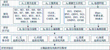
Fig. 2
The theoretical framework for soil salinization risk assessment"

Tab. 1
Indicators for soil salinization risk assessment model"
| 指标类型 | 指标名称 | 指标计算公式及方法 | 指标名称 | 指标计算公式及方法 |
|---|---|---|---|---|
| 土壤质地 | 黏土指数 | $\text { CLEX }=\frac{S W I R 1}{S W I R 2}$ | 石膏指数 | $\text { GYEX }=\frac{S W I R 1-N I R}{S W I R 2+N I R}$ |
| 碳化指数 | $\mathrm{CAEX}=\frac{G}{B}$ | 亮度指数 | $\mathrm{BI}=\sqrt{G^{2}+B^{2}}$ | |
| 植被生长状况 | 比值植被指数 | $\mathrm{RVI}=\frac{N I R}{R}$ | 差值植被指数 | $\mathrm{DVI}=N I R-R$ |
| 非线性植被指数 | $\mathrm{NLI}=\frac{N I R^{2}-R^{2}}{N I R^{2}+R}$ | 广义差分植被指数 | $\mathrm{GDVI}=\frac{N I R^{2}-R^{2}}{N I R^{2}+R^{2}}$ | |
| 增强型归一化植被 指数 | $\mathrm{ENDVI}=\frac{N I R+S W I R 1-R}{N I R+S W I R 2+R}$ | 绿色归一化差分植被 指数 | $\mathrm{GNDVI}=\frac{(R E 3-R)}{(R E 3+R)}$ | |
| 归一化植被指数 | $\mathrm{NDVI}=\frac{(N I R-R)}{(N I R+R)}$ | 修改型土壤调节植被 指数 | $\mathrm{MSAVI} =\frac{(N I R \times 2+1)-\sqrt{(N I R \times 2+1)^{2}-(N I R-R) \times 8}}{2}$ | |
| 红外百分比植被指数 | $\mathrm{IPVI}=\frac{N I R}{N I R+R}$ | 全球植被水分指数 | $\mathrm{GVMI} =\frac{(\text { NIR }+0.1)-(S W I R 1+0.02)}{(\text { NIR }+0.1)+(S W I R 1+0.02)}$ | |
| 土壤含盐量 | 盐分指数1 | $\mathrm{SI1} =\sqrt{G \times} R$ | 盐分指数10 | $\mathrm{SI10}=\frac{N I R \times R}{G}$ |
| 盐分指数2 | $ \mathrm{SI} 2=\sqrt{R+G}$ | 盐分指数11 | $\mathrm{SI11} =\frac{\text { SWIR } 1-\text { SWIR2 } 2}{\text { SWIR } 1+\text { SWIR2 }}$ | |
| 盐分指数3 | $\mathrm{SI} 3=\sqrt{G^{2}+R^{2}+N I R^{2}}$ | 盐分指数12 | $\mathrm{SI12}=\frac{G \times R}{2}$ | |
| 盐分指数4 | $\mathrm{SI} 4=\sqrt{G^{2}+R^{2}}$ | 盐分指数13 | $\mathrm{SI13}=\frac{G+R+N I R}{2}$ | |
| 盐分指数5 | $\mathrm{SI5}=\frac{S W I R 1}{N I R}$ | 盐度指数 | $\mathrm{SI}-\mathrm{T}=\frac{R}{N I R} \times 100$ | |
| 盐分指数6 | $\mathrm{SI} 6=\frac{B}{R}$ | 土壤盐碱度指数1 | $\mathrm{SSSI}-1=R-N I R$ | |
| 盐分指数7 | $\mathrm{SI} 7=\frac{B-R}{B+R}$ | 土壤盐碱度指数2 | $\mathrm{SSSI}-2=\frac{R \times N I R-N I R \times N I R}{R}$ | |
| 盐分指数8 | $\mathrm{SI} 8=\frac{G \times R}{B}$ | 归一化盐分指数 | $\mathrm{NDSI}=\frac{N I R-S W I R 1}{N I R+S W I R 1}$ | |
| 盐分指数9 | $\mathrm{SI9}=\frac{B \times R}{G}$ | 盐分比指数 | $\mathrm{SAIO}=\frac{G-N I R}{B+N I R}$ | |
| 增强型土壤盐分指数 | $\mathrm{ERSSI}=\frac{G^{2}}{R \times S W I R 1}$ | |||
| 地理环境 | Slope | |||
| 年降水量 | 国家级气象站点逐日降水量数据,采用克里金插值方法获取1 km空间分辨率的年累积降水数据 | |||
| HAILS | $\text { HAILS }=\frac{S_{C L E}}{S}$, | |||
Tab. 2
Conversion types, codes and meanings for each risk grade in the comment collection layer"
| 转换类型 | 编码 | 含义 |
|---|---|---|
| 稳定型 | a | 多年均为i风险等级 |
| 增加型 | b | 从其他风险等级转换而来 |
| 减少型 | c | 转换为其他风险等级 |
| 波动稳定型 | d | 最后一年与初始年份风险等级相同,研究期内呈波动变化 |
| 波动增加型 | e | 最后一年与初始年份相比出现i风险等级,研究期内呈波动变化 |
| 波动减少型 | f | 最后一年与初始年份相比i风险等级消失,研究期内呈波动变化 |
| 其他型 | o | 多年均不为i风险等级 |
Tab. 3
Evolutionary patterns and zoning of change characteristics in soil salinization risk evolution map"
| 变化特征分区 | 编码 | 演变模式 |
|---|---|---|
| 长期稳定型 | A | 持续极度盐渍化风险 |
| B | 持续重度盐渍化风险 | |
| C | 持续中度盐渍化风险 | |
| D | 持续轻度盐渍化风险 | |
| E | 持续无盐渍化风险 | |
| 波动稳定型 | F | 重度盐渍化风险与极度盐渍化风险相互转换并维持在一个稳定状态 |
| G | 中度盐渍化风险与重度或极度盐渍化风险相互转换并维持在一个稳定状态 | |
| H | 轻度盐渍化风险与中度、重度或极度盐渍化风险相互转换并维持在一个稳定状态 | |
| I | 无盐渍化风险与轻度、中度或重度风险盐渍化相互转换并维持在一个稳定状态 | |
| 风险降级型 | J | 重度盐渍化风险(波动)增加,极度盐渍化风险(波动)减少 |
| K | 中度盐渍化风险(波动)增加,重度或极度盐渍化风险(波动)减少 | |
| L | 轻度盐渍化风险(波动)增加,中度或重度盐渍化风险(波动)减少,极度盐渍化稳定 | |
| M | 轻度盐渍化风险稳定,中度盐渍化风险(波动)增加,重度盐渍化风险(波动)减少 | |
| N | 无盐渍化风险(波动)增加,轻度、中度、重度或极度盐渍化风险(波动)减少 | |
| O | 无盐渍化风险稳定,轻度盐渍化风险(波动)增加,中度或重度盐渍化风险(波动)减少 | |
| 风险升级型 | P | 重度盐渍化风险(波动)减少,极度盐渍化风险(波动)增加 |
| Q | 中度盐渍化风险(波动)减少,重度或极度盐渍化风险(波动)增加 | |
| R | 轻度盐渍化风险(波动)减少,中度、重度或极度盐渍化风险(波动)增加 | |
| S | 轻度盐渍化风险稳定,中度盐渍化风险(波动)减少,重度盐渍化风险(波动)增加 | |
| T | 无盐渍化风险(波动)减少,轻度、中度或重度盐渍化风险(波动)增加 | |
| U | 无盐渍化风险稳定,中度盐渍化风险(波动)减少,重度盐渍化风险(波动)增加 | |
| V | 无盐渍化风险稳定,轻度盐渍化风险(波动)减少,中度或重度盐渍化风险(波动)增加 |
Tab. 4
The management zoning of soil saline"
| 治理分区 | 变化特征 | ||||
|---|---|---|---|---|---|
| 长期稳 定型 | 波动稳 定型 | 风险降 级型 | 风险升 级型 | ||
| 稳定性 | 演变0次 | 优化区 | 保护区 | 保护区 | 预警区 |
| 演变1次 | 保护区 | 保护区 | 预警区 | 预警区 | |
| 演变2次 | 保护区 | 预警区 | 预警区 | 修复区 | |
| 演变3次 | 预警区 | 预警区 | 修复区 | 修复区 | |

Fig. 3
Correlation of soil salinization risk assessment results with measured soil conductivity in 2022"
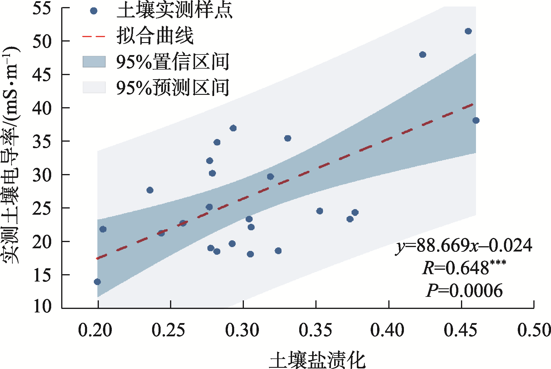
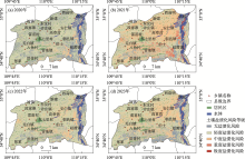
Fig. 4
Temporal and spatial distribution of soil salinization risk level from 2020 to 2023"

Tab. 5
Area and proportion of each risk level of soil salinization"
| 土壤盐渍化风险等级 | 2020年 | 2021年 | 2022年 | 2023年 | |||||||
|---|---|---|---|---|---|---|---|---|---|---|---|
| 面积/km2 | 占比/% | 面积/km2 | 占比/% | 面积/km2 | 占比/% | 面积/km2 | 占比/% | ||||
| 无盐渍化风险 | 365.825 | 22.876 | 141.668 | 8.859 | 184.744 | 11.552 | 207.160 | 12.954 | |||
| 轻度盐渍化风险 | 1083.651 | 67.763 | 720.603 | 45.062 | 1153.416 | 72.125 | 939.002 | 58.717 | |||
| 中度盐渍化风险 | 148.805 | 9.305 | 630.525 | 39.429 | 252.777 | 15.807 | 435.721 | 27.246 | |||
| 重度盐渍化风险 | 0.906 | 0.057 | 97.113 | 6.073 | 8.246 | 0.516 | 17.275 | 1.080 | |||
| 极度盐渍化风险 | 0.002 | 0.000 | 9.236 | 0.578 | 0.006 | 0.000 | 0.033 | 0.002 | |||
| 中度及以上盐渍化风险 | 149.713 | 9.362 | 736.874 | 46.080 | 261.029 | 16.323 | 453.029 | 28.328 | |||
Tab. 6
Area and proportion of conversion types for each risk level of soil salinization"
| 转换类型 | 风险等级 | |||||||||||||
|---|---|---|---|---|---|---|---|---|---|---|---|---|---|---|
| 无盐渍化风险 | 轻度盐渍化风险 | 中度盐渍化风险 | 重度盐渍化风险 | 极度盐渍化风险 | ||||||||||
| 面积/km2 | 占比/% | 面积/km2 | 占比/% | 面积/km2 | 占比/% | 面积/km2 | 占比/% | 面积/km2 | 占比/% | |||||
| 稳定型 | 37.533 | 7.162 | 369.879 | 25.429 | 23.214 | 2.749 | 0.049 | 0.046 | 0.000 | 0.000 | ||||
| 增加型 | 84.456 | 16.115 | 215.426 | 14.810 | 174.804 | 20.697 | 10.711 | 9.882 | 0.030 | 0.328 | ||||
| 减少型 | 216.618 | 41.333 | 208.267 | 14.318 | 43.763 | 5.182 | 0.789 | 0.728 | 0.002 | 0.017 | ||||
| 波动稳定型 | 127.370 | 24.303 | 430.167 | 29.573 | 406.902 | 48.178 | 90.414 | 83.417 | 9.240 | 99.630 | ||||
| 波动增加型 | 15.803 | 3.015 | 39.516 | 2.717 | 175.894 | 20.826 | 6.420 | 5.923 | 0.002 | 0.025 | ||||
| 波动减少型 | 42.302 | 8.072 | 191.314 | 13.153 | 20.003 | 2.368 | 0.004 | 0.004 | 0.000 | 0.000 | ||||
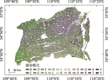
Fig. 5
Information evolution map of soil salinization risk from 2020 to 2023"

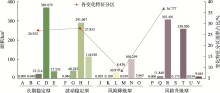
Fig. 6
Statistics of information evolution map of soil salinization risk from 2020 to 2023"

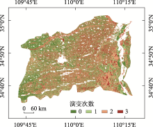
Fig. 7
Stability map of soil salinization risk evolution from 2020 to 2023"

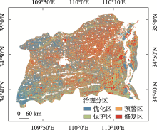
Fig. 8
Saline soil management zoning in Dali County"


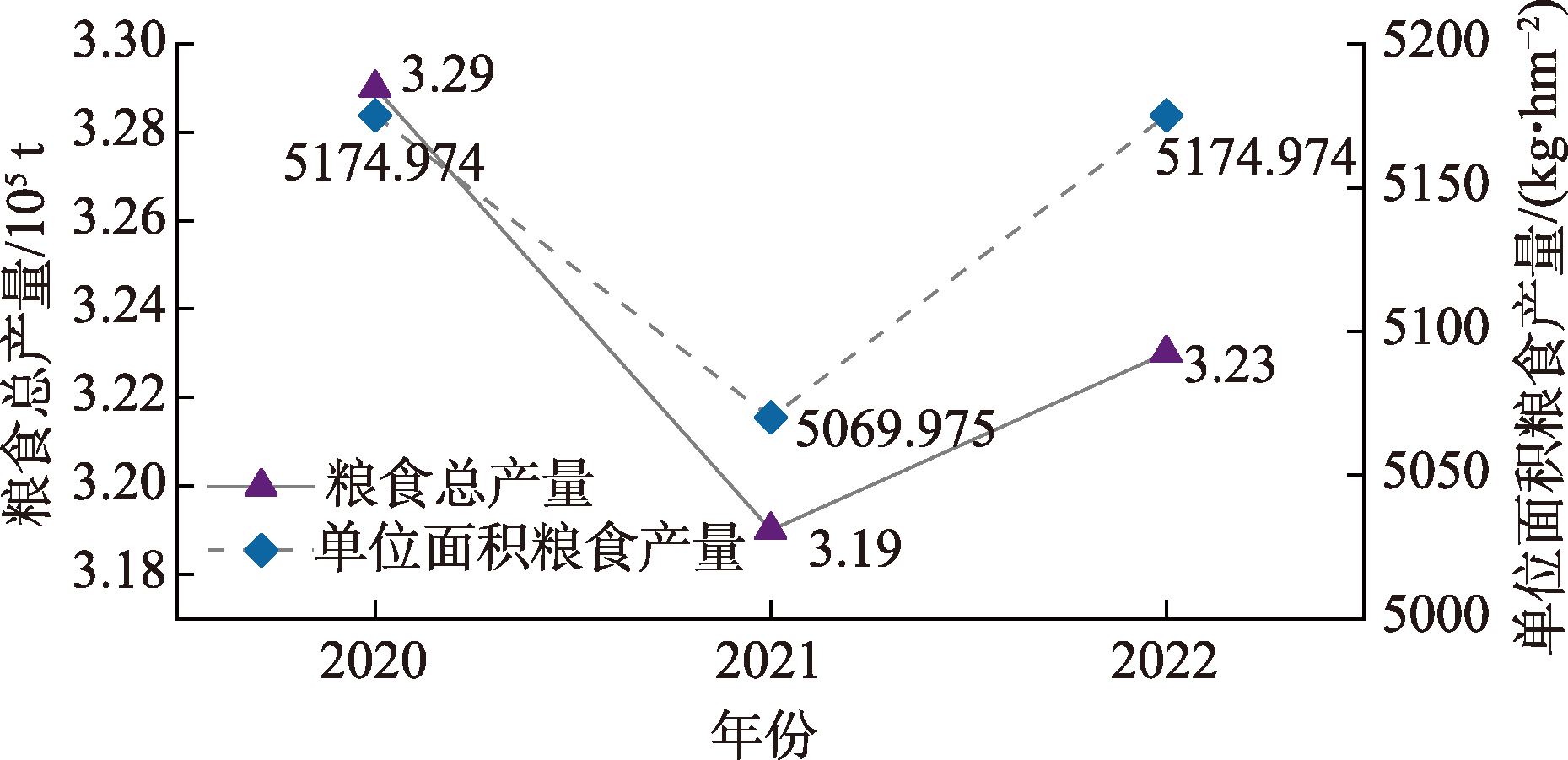
Fig. 9
Grain production from 2020 to 2022 in Dali County"
| [1] |
石聪, 陈礼瀚, 张怡菲, 等. 新疆小海子灌区耕地土壤盐渍化特征研究[J]. 干旱区地理, 2023, 46(8): 1314-1323.
doi: 10.12118/j.issn.1000-6060.2023.008 |
|
[Shi Cong, Chen Lihan, Zhang Yifei, et al. Soil salinization characteristics of cultivated land in Xiaohaizi Irrigation Area of Xinjiang[J]. Arid Land Geography, 2023, 46(8): 1314-1323.]
doi: 10.12118/j.issn.1000-6060.2023.008 |
|
| [2] |
Rengasamy P. World salinization with emphasis on Australia[J]. Journal of Experimental Botany, 2006, 57(5): 1017-1023.
doi: 10.1093/jxb/erj108 pmid: 16510516 |
| [3] | 刘梅先, 杨劲松. 土壤盐分的原位测定方法[J]. 土壤, 2011, 43(5): 688-697. |
| [Liu Meixian, Yang Jinsong. In-situ determination methods for soil salinity[J]. Soils, 2011, 43(5): 688-697.] | |
| [4] | Elnaggar A A, Noller J S. Application of remote-sensing data and decision-tree analysis to mapping salt-affected soils over large areas[J]. Remote Sensing, 2009, 2(1): 151-165. |
| [5] | Wang H, Jia G. Satellite-based monitoring of decadal soil salinization and climate effects in a semiarid region of China[J]. Advances in Atmospheric Sciences, 2012, 29(5): 1089-1099. |
| [6] | Kabiraj S, Jayanthi M, Vijayakumar S, et al. Comparative assessment of satellite images spectral characteristics in identifying the different levels of soil salinization using machine learning techniques in Google Earth Engine[J]. Earth Science Informatics, 2022, 15(4): 2275-2288. |
| [7] |
洪国军, 谢俊博, 张灵, 等. 基于多光谱影像的阿拉尔垦区棉田土壤盐分反演[J]. 干旱区研究, 2024, 41(5): 894-904.
doi: 10.13866/j.azr.2024.05.16 |
|
[Hong Guojun, Xie Junbo, Zhang Ling, et al. Monitoring soil salinization of cotton fields in the Aral Reclamation Area using multispectral imaging[J]. Arid Zone Research, 2024, 41(5): 894-904.]
doi: 10.13866/j.azr.2024.05.16 |
|
| [8] | Zixuan Z, Beibei N, Xinju L, et al. Estimation and dynamic analysis of soil salinity based on UAV and Sentinel-2A multispectral imagery in the coastal area, China[J]. Land, 2022, 11(12): 2307. |
| [9] | Jiaqiang W, Jie P, Hongyi L, et al. Soil salinity mapping using machine learning algorithms with the Sentinel-2 MSI in arid areas, China[J]. Remote Sensing, 2021, 13(2): 305. |
| [10] | Seydehmet J, Lv G H, Abliz A, et al. Irrigation salinity risk assessment and mapping in arid oasis, Northwest China[J]. Water, 2018, 10(7): 966. |
| [11] |
De Z, Jianchun X, Li W, et al. Identifying and managing risk factors for salt-affected soils: A case study in a semi-arid region in China[J]. Environmental Monitoring and Assessment, 2015, 187(7): 421.
doi: 10.1007/s10661-015-4639-7 pmid: 26063060 |
| [12] |
Jie B, Junli L, Anmin B, et al. Spatial-temporal variations of ecological vulnerability in the Tarim River Basin, Northwest China[J]. Journal of Arid Land, 2021, 13(8): 814-834.
doi: 10.1007/s40333-021-0079-0 |
| [13] | 依力亚斯江·努尔麦麦提, 师庆东, 阿不都拉·阿不力孜, 等. 灰色评估模型定量评价于田绿洲土壤盐渍化风险[J]. 农业工程学报, 2019, 35(8): 176-184. |
| [Ilyas Nurmemet, Shi Qingdong, Abdulla Abliz, et al. Quantitative evaluation of soil salinization risk in Keriya Oasis based on grey evaluation model[J]. Transactions of the Chinese Society of Agricultural Engineerin, 2019, 35(8): 176-184.] | |
| [14] | Wang Z, Zhang F, Zhang X, et al. Quantitative evaluation of spatial and temporal variation of soil salinization risk using GIS-based geostatistical method[J]. Remote Sensing, 2020, 12(15): 2405. |
| [15] | Liu Y, Mu Z, Dong W, et al. Establishment of an evaluation indicator system and evaluation criteria for the Weihe River ecological watersheds[J]. Water, 2024, 16(17): 2393-2393. |
| [16] | 张倩. 基于粒子群算法的大荔县农业水资源优化配置研究[D]. 西安: 西安理工大学, 2019. |
| [Zhang Qian. Study Research on Optimal Allocation of Agricultural Water Resources in Dali County Based on Particle Swarm Optimization[D]. Xi’an: Xi’an University of Technology, 2019.] | |
| [17] | Wu J C, Gao W W, Zheng Z J, et al. Study of human activity intensity from 2015 to 2020 based on remote sensing in Anhui Province, China[J]. Remote Sensing, 2023, 15(8): 2029. |
| [18] | 吴炳方. 中国土地覆被[M]. 北京: 科学出版社, 2017. |
| [Wu Bingfang. Land Cover of China[M]. Beijing: Science Press, 2017.] | |
| [19] | 环境保护部. 土壤电导率的测定电极法(HJ 802-2016)[S]. 北京: 中国环境科学出版社, 2016. |
| [Ministry of Environmental Protection. Soil Quality-determination of Conductivity-electrode Method[S]. Beijing: China Environmental Science Press, 2016.] | |
| [20] | 刘子金, 徐存东, 朱兴林, 等. 干旱荒漠区人工绿洲土壤盐碱化风险综合评估与演变分析[J]. 中国环境科学, 2022, 42(1): 367-379. |
| [Liu Zijin, Xu Cundong, Zhu Xinglin, et al. Comprehensive assessment and evolution analysis of soil salinization in artificial oasis in arid desert area[J]. China Environmental Science, 2022, 42(1): 367-379.] | |
| [21] |
解雪峰, 濮励杰, 朱明, 等. 土壤水盐运移模型研究进展及展望[J]. 地理科学, 2016, 36(10): 1565-1572.
doi: 10.13249/j.cnki.sgs.2016.10.014 |
|
[Xie Xuefeng, Pu Lijie, Zhu Ming, et al. Evolution and prospects in modeling of water and salt transport in soils[J]. Scientia Geographica Sinica, 2016, 36(10): 1565-1572.]
doi: 10.13249/j.cnki.sgs.2016.10.014 |
|
| [22] | Qi J W, Zhang Y C, Zhang J Q, et al. Research on the evaluation of geological environment carrying capacity based on the AHP-CRITIC empowerment method[J]. Land, 2022, 11(8): 1196-1196. |
| [23] |
Shekar P R, Mathew A. Integrated assessment of groundwater potential zones and artificial recharge sites using GIS and Fuzzy-AHP: A case study in Peddavagu watershed, India[J]. Environmental Monitoring and Assessment, 2023, 195(7): 906.
doi: 10.1007/s10661-023-11474-5 pmid: 37382701 |
| [24] | Gong J, Jin T T, Wang S M, et al. Is ecological vulnerability assessment based on the VSD model and AHP-Entropy method useful for loessial forest landscape protection and adaptative management? A case study of Ziwuling Mountain Region, China[J]. Ecological Indicators, 2022, 143(12): 109379. |
| [25] | 李帆, 贾夏, 赵永华, 等. 基于DPSIR模型的黄土高原生态敏感性演变格局及驱动力分析[J]. 农业工程学报, 2023, 39(9): 241-251, 303. |
| [Li Fan, Jia Xia, Zhao Yonghua, et al. Evolutionary pattern and driving forces of ecological sensitivity in the Loess Plateau using DPSIR model[J]. Transactions of the Chinese Society of Agricultural Engineering, 2023, 39(9): 241-251, 303.] | |
| [26] |
李相, 丁建丽, 侯艳军, 等. 干旱半干旱区土壤含盐量和电导率高光谱估算[J]. 冰川冻土, 2015, 37(4): 1050-1058.
doi: 10.7522/j.issn.1000-0240.2015.0117 |
|
[Li Xiang, Ding Jianli, Hou Yanjun, et al. Estimating the soil salt content and electrical conductivity in semi-arid and arid areas by using hyperspectral data[J]. Journal of Glaciology and Geocryology, 2015, 37(4): 1050-1058.]
doi: 10.7522/j.issn.1000-0240.2015.0117 |
|
| [27] |
刘旭辉, 白云岗, 柴仲平, 等. 基于多光谱遥感的典型绿洲棉田春季土壤盐分反演及验证[J]. 干旱区地理, 2022, 45(4): 1165-1175.
doi: 10.12118/j.issn.1000-6060.2021.477 |
|
[Liu Xuhui, Bai Yungang, Chai Zhongping, et al. Inversion and validation of soil salinity based on multispectral remote sensing in typical oasis cotton field in spring[J]. Arid Land Geography, 2022, 45(4): 1165-1175.]
doi: 10.12118/j.issn.1000-6060.2021.477 |
|
| [28] | Guo B, Lu M, Fan Y W, et al. A novel remote sensing monitoring index of salinization based on three-dimensional feature space model and its application in the Yellow River Delta of China[J]. Geomatics Natural Hazards & Risk, 2023, 14(1): 95-116. |
| [29] | 王青, 李富程, 李国蓉, 等. 基于“压力-状态-响应”框架的长江上游防护林健康评价[J]. 长江流域资源与环境, 2010, 19(8): 953-958. |
| [Wang Qing, Li Fucheng, Li Guorong, et al. Health assessment of protection forest based on pressure-state-response model[J]. Resources and Environment in the Yangtze Basin, 2010, 19(8): 953-958.] | |
| [30] | Zhang J, Cai J, Xu D, et al. Soil salinization poses greater effects than soil moisture on field crop growth and yield in arid farming areas with intense irrigation[J]. Journal of Cleaner Production, 2024, 451(32): 142007-142022. |
| [31] |
蒋磊, 刘小龙, 郭帅, 等. 基于Logistic回归分析的土壤盐渍化易发性评价——以新疆南疆塔里木灌区为例[J]. 干旱区地理, 2023, 46(11): 1858-1867.
doi: 10.12118/j.issn.1000-6060.2023.073 |
|
[Jiang Lei, Liu Xiaolong, Guo Shuai, et al. Evaluation of soil salinization susceptibility based on Logistic regression analysis: A case of Tarim irrigation area in southern Xinjiang[J]. Arid Land Geography, 2023, 46(11): 1858-1867.]
doi: 10.12118/j.issn.1000-6060.2023.073 |
|
| [32] | 扶松林, 孔令颖, 周海香, 等. 泾河流域粮食产量与生产潜力时空分布特征及其与MODIS-GPP的关系[J]. 干旱地区农业研究, 2020, 38(6): 192-199. |
| [Fu Songlin, Kong Lingying, Zhou Haixiang, et al. Spatial-temporal distribution characteristics of grain yield and its potential productivity in the Jing River Basin and their relationships with MODIS-GPP[J]. Agricultural Research in the Arid Areas, 2020, 38(6): 192-199.] | |
| [33] | 孔坚文, 王连喜, 李琪, 等. 陕西省主要农业气象灾害分析及其对粮食产量的影响[J]. 干旱地区农业研究, 2015, 33(4): 220-226. |
| [Kong Jianwen, Wang Lianxi, Li Qi, et al. Analyses of main agro-meteorological disasters and their impacts on food production in Shaanxi Province[J]. Agricultural Research in the Arid Areas, 2015, 33(4): 220-226.] | |
| [34] |
宋喜芳, 姚海荣, 张小飞, 等. 陕西省粮食产量影响因素的灰色关联分析——基于面板数据的实证研究[J]. 中国农学通报, 2020, 36(28): 158-164.
doi: 10.11924/j.issn.1000-6850.casb20191100858 |
|
[Song Xifang, Yao Hairong, Zhang Xiaofei, et al. Grey correlation analysis of the influence factors of grain yield in Shaanxi: Empirical research based on panel data[J]. Chinese Agricultural Science Bulletin, 2020, 36(28): 158-164.]
doi: 10.11924/j.issn.1000-6850.casb20191100858 |
|
| [35] | 貟培东, 曾永年, 历华. 多尺度遥感影像融合技术及其算法研究进展[J]. 遥感信息, 2006(6): 67-71. |
| [Yun Peidong, Zeng Yongnian, Li Hua. Advances in algorithms and techniques of multi-scale data fusion[J]. Remote Sensing Information, 2006(6): 67-71.] | |
| [36] | Shtiliyanova A, Bellocchi G, Borras D, et al. Kriging-based approach to predict missing air temperature data[J]. Computers and Electronics in Agriculture, 2017, 142(33): 440-449. |
| [37] | Colombani N, Mastrocicco M, Giambastian B M S. Predicting salinization trends in a lowland coastal aquifer: Comacchio (Italy)[J]. Water Resources Management, 2015, 29(2): 603-618. |
| [38] | Xudong Z, Changjian S, Manabu F, et al. Numerical and experimental study on water-heat-salt transport patterns in shallow bare soil with varying salt contents under evaporative conditions: A comparative investigation[J]. Journal of Hydrology, 2023, 621(61): 129564. |
| [39] | 樊会敏, 许明祥, 李彬彬, 等. 渭北地区农田土壤物理性质对土壤剖面盐分的影响[J]. 水土保持学报, 2017, 31(4): 198-204. |
| [Fan Huimin, Xu Mingxiang, Li Binbin, et al. Influence of soil physical properties on salt content in soil profile of farmland in Weibei Region[J]. Journal of Soil and Water Conservation, 2017, 31(4): 198-204.] | |
| [40] |
苏春利, 纪倩楠, 陶彦臻, 等. 河套灌区西部土壤盐渍化分异特征及其主控因素[J]. 干旱区研究, 2022, 39(3): 916-923.
doi: 10.13866/j.azr.2022.03.25 |
|
[Su Chunli, Ji Qiannan, Tao Yanzhen, et al. Differentiation characteristics and main influencing factors of soil salinization in the West of Hetao Irrigation Area[J]. Arid Zone Research, 2022, 39(3): 916-923.]
doi: 10.13866/j.azr.2022.03.25 |
|
| [41] | 赵起越, 夏夜, 邹本东. 土壤盐渍化成因危害及恢复[J]. 农业与技术, 2022, 42(11): 115-119. |
| [Zhao Qiyue, Xia Ye, Zou Bendong. Causes, hazards and rehabilitation of soil salinization[J]. Agriculture and Technology, 2022, 42(11): 115-119.] | |
| [42] | Khamidov M, Ishchanov J, Hamidov A, et al. Impact of soil surface temperature on changes in the groundwater level[J]. Water, 2023, 15(21): 3865. |
| [43] | 杜秉晨曦, 程勇翔, 吴玲. 准噶尔盆地植被与土壤盐渍化关联性变化趋势分析[J]. 生态学报, 2021, 41(23): 9364-9376. |
| [Du Bingchenxi, Cheng Yongxiang, Wu Ling. Analysis of negative correlation between vegetation and soil salinization in Junggar Basin[J]. Acta Ecologica Sinica, 2021, 41(23): 9364-9376.] | |
| [44] | 姚媛. 陕西农垦沙苑农场粮食丰产的秘诀是什么?[N]. 农民日报, 2024-07-10(007). |
| [Yao Yuan. What is the secret of abundant grain production at Shaanxi Nongken Shayuan Farm?[N]. Farmers’ Daily, 2024-07-10(007).] | |
| [45] | 苏怡. “薄地”生金有良方[N]. 陕西日报, 2024-08-29(002). |
| [Su Yi. There are good ways to make gold from ‘thin land’[N]. Shaanxi Daily, 2024-08-29(002).] |
|
||