Arid Zone Research ›› 2025, Vol. 42 ›› Issue (11): 2104-2116.doi: 10.13866/j.azr.2025.11.13
• Ecology and Environment • Previous Articles Next Articles
HUANG Zhipu1( ), WANG Junde2, CHENG Yufei2, ZHOU Haohao3, ZHANG Zhan4, BAO Zhiwei2, YANG Chuanguo1()
Received:2025-04-15
Revised:2025-10-14
Online:2025-11-15
Published:2025-12-13
Contact:
YANG Chuanguo
E-mail:zhiphuang@163.com;cgyang@hhu.edu.cn
HUANG Zhipu, WANG Junde, CHENG Yufei, ZHOU Haohao, ZHANG Zhan, BAO Zhiwei, YANG Chuanguo. Land use change and future habitat quality evaluation in the ecologically fragile areas of the middle and lower reaches of the Shule River[J].Arid Zone Research, 2025, 42(11): 2104-2116.
Add to citation manager EndNote|Reference Manager|ProCite|BibTeX|RefWorks
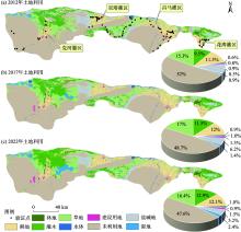
Fig. 1
Land use distribution from 2012 to 2022"

Tab. 1
Basic data information"
| 数据类型 | 数据名称 | 空间分辨率 | 数据来源 |
|---|---|---|---|
| 土地利用数据 | 土地利用2012年 | 30 m | 中国资源卫星中心数据网站( |
| 土地利用2017年、2022年 | 2 m | ||
| 自然因子数据 | 高程 | 30 m | CGIAR-CS( |
| 坡度 | 30 m | 基于DEM提取 | |
| 年均降水量 | 1000 m | 国家青藏高原中心( | |
| 年均气温 | 1000 m | ||
| 年潜在蒸散发量 | 1000 m | ||
| 土壤类型 | 1000 m | 中国科学院资源环境科学数据中心( | |
| 土壤风力侵蚀度 | 1000 m | ||
| 年最大NDVI | 30 m | 国家生态科学数据中心( | |
| 社会经济数据 | 人口密度 | 1000 m | 中国科学院资源环境科学数据中心( |
| 人均GDP | 1000 m | ||
| 区域可达性数据 | 距主要道路的距离 | 300 m | OpenStreetMap( |
| 距水系的距离 | 300 m |
Tab. 2
Settings for three scenario modes"
| 模拟发展情景 | 基本要求 |
|---|---|
| 自然发展情景 | 假如未来的土地利用政策不变,土地利用变化情况与2017—2022年的变化情况保持一致,各地类的转移概率不变,计算2035年的各地类土地利用需求量,不设置功能限制区 |
| 耕地保护情景 | 《酒泉市2021—2035年国土面积发展规划》要求严格落实耕地保护制度,遏制耕地“非农化”,坚守3001.9 km2耕地保护红线,确保耕地资源有效利用和保护。此情景通过耕地向草地、林地、灌木、水域转移发生概率减少40%,禁止耕地向建设用地、未利用地和盐碱地的转变,加强对耕地转出的管理,保证耕地面积不减少 |
| 生态保护情景 | 《酒泉市“十四五”生态环境保护规划》要求将重要水源涵养、生物多样性保护及水土保持等重要区域划入生态保护红线,加强对湿地生态环境的保护和荒漠化、盐碱化的修复治理。因此,该情景设置禁止林地、灌木、草地和湿地向建设用地、盐碱地和未利用地转变,水域作为功能限制区。同时,将未利用地向草地、林地、灌木、水域、湿地转移发生概率提高20%,盐碱地向草地、林地、灌木、水域、湿地转移提高50% |
Tab. 3
Maximum distance of influence, weight and type of decay over space of threat factors"
| 胁迫源 | 最大胁迫距离/km | 权重 | 方式 |
|---|---|---|---|
| 耕地 | 2 | 0.7 | 线性 |
| 建设用地 | 3 | 0.7 | 指数 |
| 未利用地 | 3 | 0.3 | 线性 |
| 盐碱地 | 4 | 0.6 | 线性 |
Tab. 4
Sensitivity coefficients of various land use types to different threat factors"
| 土地类型 | 适宜性系数 | 耕地 | 建设用地 | 未利用地 | 盐碱地 |
|---|---|---|---|---|---|
| 耕地 | 0.5 | 0 | 0.6 | 0.4 | 0.2 |
| 林地 | 1 | 0.7 | 0.9 | 0.5 | 0.4 |
| 灌木 | 0.9 | 0.5 | 0.7 | 0.6 | 0.4 |
| 草地 | 0.8 | 0.5 | 0.6 | 0.5 | 0.6 |
| 水体 | 1 | 0.7 | 0.8 | 0.7 | 0.5 |
| 建设用地 | 0 | 0 | 0 | 0 | 0 |
| 未利用地 | 0.05 | 0.3 | 0.1 | 0 | 0.1 |
| 盐碱地 | 0.1 | 0.1 | 0.3 | 0.6 | 0 |
| 湿地 | 0.6 | 0.5 | 0.4 | 0.5 | 0.7 |
Tab. 5
Changes in land use in the watershed from 2012 to 2022"
| 土地类型 | 2012年 | 2017年 | 2022年 | 2012—2017年 | 2017—2022年 | 2012—2022年 | ||||||||
|---|---|---|---|---|---|---|---|---|---|---|---|---|---|---|
| 面积/km2 | 面积/km2 | 面积/km2 | 变化/km2 | K/% | 变化/km2 | K/% | 变化/km2 | K/% | ||||||
| 耕地 | 1716.68 | 1782.95 | 1804.20 | 66.27 | 0.77 | 21.25 | 0.24 | 87.52 | 0.97 | |||||
| 林地 | 92.43 | 139.10 | 153.98 | 46.67 | 10.10 | 14.88 | 2.14 | 61.55 | 7.99 | |||||
| 灌木 | 1412.72 | 1718.40 | 1915.05 | 305.68 | 4.33 | 196.65 | 2.29 | 502.33 | 5.25 | |||||
| 草地 | 2283.93 | 2536.36 | 2444.17 | 252.43 | 2.21 | -92.19 | -0.73 | 160.24 | 1.31 | |||||
| 水体 | 114.83 | 146.03 | 129.45 | 31.20 | 5.43 | -16.58 | -2.27 | 14.62 | 2.26 | |||||
| 建设用地 | 139.65 | 197.18 | 223.39 | 57.53 | 8.24 | 26.21 | 2.66 | 83.74 | 7.50 | |||||
| 未利用地 | 7735.76 | 7231.97 | 7081.15 | -503.79 | -1.30 | -150.82 | -0.42 | -654.61 | -1.85 | |||||
| 盐碱地 | 1260.00 | 927.92 | 775.92 | -332.08 | -5.27 | -152.00 | -3.28 | -484.08 | -12.48 | |||||
| 湿地 | 133.73 | 209.82 | 362.42 | 76.09 | 11.38 | 152.60 | 14.55 | 228.69 | 12.62 | |||||
| LC/% | - | - | - | 1.123 | 0.553 | 0.765 | ||||||||

Fig. 2
Conversion map of main types of land use in the middle and lower reaches of the Shule River Basin from 2012 to 2022"
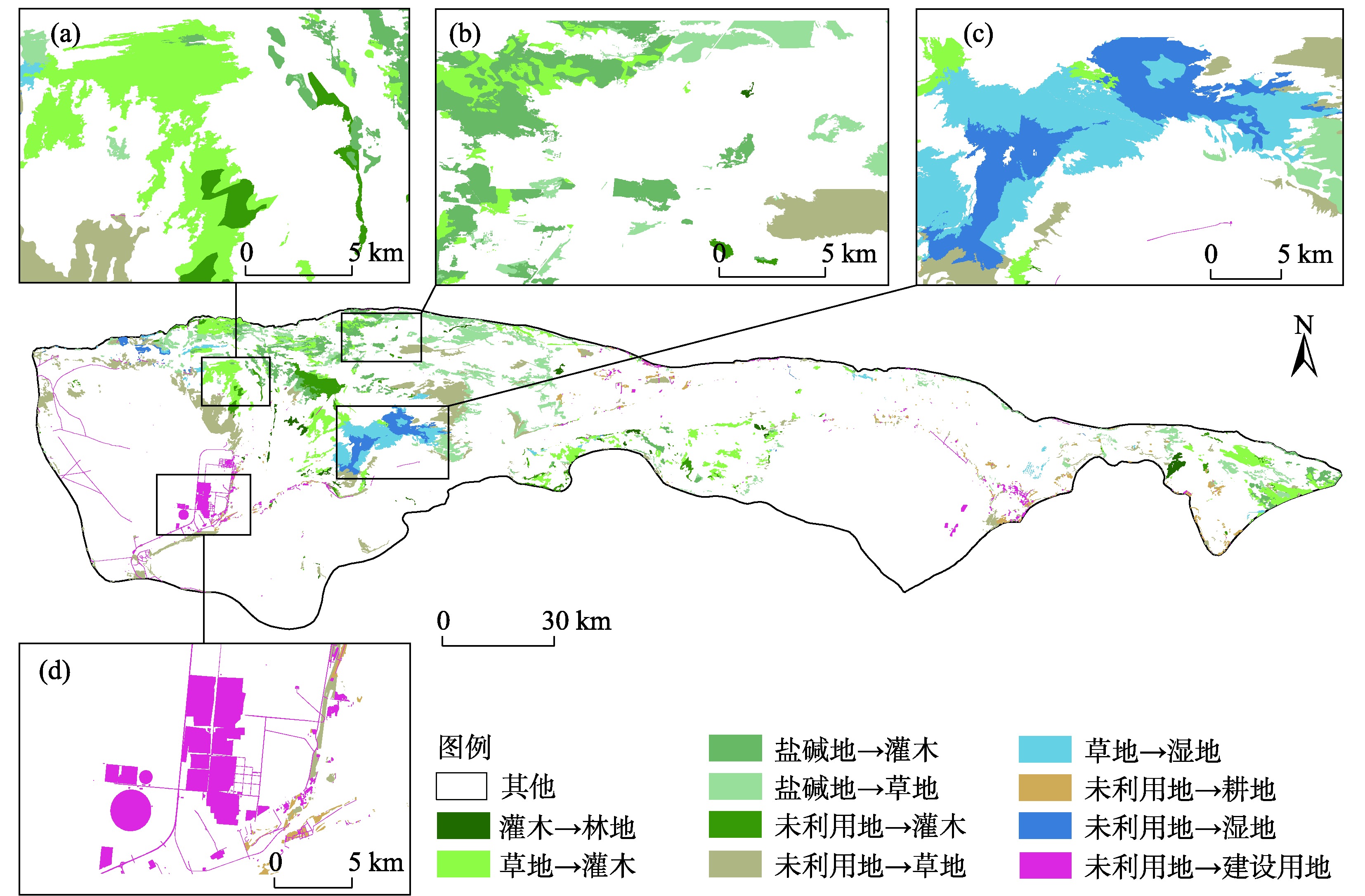
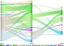
Fig. 3
Land use transition from 2012 to 2022 (changing part)"

Fig. 4
Comparison of land use simulation results and actual data in 2022"

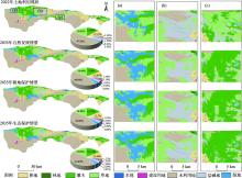
Fig. 5
Current land use in 2022 and land use distribution under three scenarios in 2035"

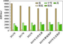
Fig. 6
Habitat quality in the middle and lower reaches of the Shule River Basin"
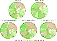
Fig. 7
Chord diagram of watershed habitat quality transfer (changing part)"

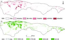
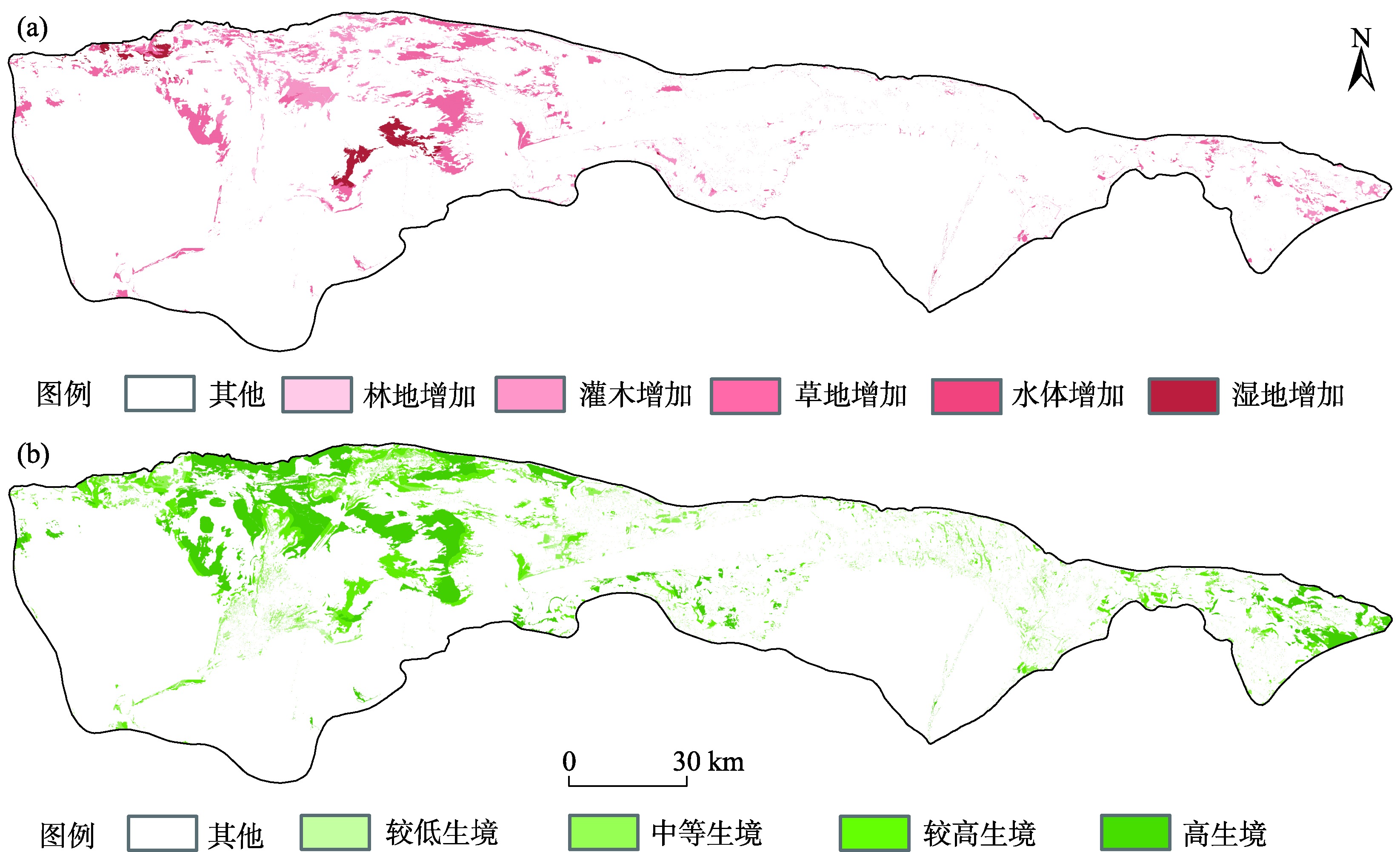
Fig. 8
Distribution of conversion from unused land and saline-alkali land to ecological vegetation (a), habitat quality improvement range and current level (b) from 2012 to 2022"
| [1] | 刘纪远, 张增祥, 庄大方, 等. 20世纪90年代中国土地利用变化时空特征及其成因分析[J]. 地理研究, 2003, 22(1): 1-12. |
| [ Liu Jiyuan, Zhang Zengxiang, Zhuang Dafang, et al. A study on the spatial-temporal dynamic changes of land-use and driving forces analyses of China in the 1990s[J]. Geographical Research, 2003, 22(1): 1-12. ] | |
| [2] |
李沛尧, 王新军, 许世贤, 等. 基于PLUS土地利用模拟的阿克苏河流域NEP时空格局研究[J]. 干旱区研究, 2024, 41(6): 1059-1068.
doi: 10.13866/j.azr.2024.06.14 |
|
[ Li Peiyao, Wang Xinjun, Xu Shixian, et al. Spatiotemporal pattern of NEP in Aksu River Basin based on PLUS land use simulation[J]. Arid Zone Research, 2024, 41(6): 1059-1068. ]
doi: 10.13866/j.azr.2024.06.14 |
|
| [3] | 孙一帆, 徐梦菲, 汪霞. 洛阳市土地利用景观格局时空演变与预测分析[J]. 人民黄河, 2024, 46(8): 110-116, 129. |
| [ Sun Yifan, Xu Mengfei, Wang Xia. Spatial-temporal evolution and prediction analysis of land use and landscape pattern in Luoyang City[J]. Yellow River, 2024, 46(8): 110-116, 129. ] | |
| [4] | Li C, Wu Y, Gao B, et al. Multi-scenario simulation of ecosystem service value for optimization of land use in the Sichuan-Yunnan ecological barrier, China[J]. Ecological Indicators, 2021, 132: 10 8328. |
| [5] | 高畅, 郭伟玲, 徐刘洋, 等. 基于PLUS模型的皖江城市带土地利用变化模拟与多情景预测[J/OL]. 南京林业大学学报(自然科学版), 1-12[2025-10-16]. |
| [ Gao Chang, Guo Weiling, Xu Liuyang, et al. Simulation and multi-scenario prediction of land use change in the urban belt of Wan jiang River based on the PLUS model[J/OL]. Journal of Nanjing Forestry University (Natural Sciences Edition), 1-12[2025-10-16]. ] | |
| [6] |
李国清, 柏永青, 杨轩, 等. 基于深度学习的高分辨率遥感影像土地覆盖自动分类方法[J]. 地球信息科学学报, 2021, 23(9): 1690-1704.
doi: 10.12082/dqxxkx.2021.200795 |
| [ Li Guoqing, Bai Yongqing, Yang Xuan, et al. Automatic deep learning land cover classification methods of high-resolution remotely sensed images[J]. Journal of Geo-information Science, 2021, 23(9): 1690-1704. ] | |
| [7] | 谢怡凡, 刘耀林, 庞博文, 等. 基于高分辨率遥感影像的NPP估算及驱动因子研究——以银川市为例[J/OL]. 武汉大学学报(信息科学版), 1-17[2025-04-14]. |
| [ Xie Yifan, Liu Yaolin, Pang Bowen, et al. Study on estimation of net primary productivity based on high resolution remote sensing image and its influencing factors in Yinchuan City[J/OL]. Geomatics and Information Science of Wuhan University, 1-17[2025-04-14]. ] | |
| [8] |
胡丰, 张艳, 郭宇, 等. 基于PLUS和InVEST模型的渭河流域土地利用与生境质量时空变化及预测[J]. 干旱区地理, 2022, 45(4): 1125-1136.
doi: 10.12118/j.issn.1000-6060.2021.510 |
|
[ Hu Feng, Zhang Yan, Guo Yu, et al. Spatial and temporal changes in land use and habitat quality in the Weihe River Basin based on the PLUS and InVEST models and predictions[J]. Arid Land Geography, 2022, 45(4): 1125-1136. ]
doi: 10.12118/j.issn.1000-6060.2021.510 |
|
| [9] |
Wu C B, Cui Y Y, Zhen J L, et al. Spatio-temporal change of habitat quality in Northeast China: Driving factors exploration based on land use and land cover change[J]. Land Degradation & Development, 2025, 36(11): 3742-3755.
doi: 10.1002/ldr.v36.11 |
| [10] |
王洋, 冯卓亚, 许丽, 等. 塔里木河流域生境质量与土地利用变化响应及驱动力[J]. 干旱区研究, 2024, 41(12): 2132-2142.
doi: 10.13866/j.azr.2024.12.14 |
|
[ Wang Yang, Feng Zhuoya, Xu Li, et al. Response and influencing factors of habitat quality and land use change in the Tarim River Basin[J]. Arid Zone Research, 2024, 41(12): 2132-2142. ]
doi: 10.13866/j.azr.2024.12.14 |
|
| [11] | 钟莉娜, 王军. 基于InVEST模型评估土地整治对生境质量的影响[J]. 农业工程学报, 2017, 33(1): 250-255. |
| [ Zhong Lina, Wang Jun. Evaluation on effect of land consolidation on habitat quality based on InVEST model[J]. Transactions of the Chinese Society of Agricultural Engineering, 2017, 33(1): 250-255. ] | |
| [12] |
Sun Y, Yin X, Mao L. Landscape pattern prediction method based on ANN-CA-Markov coupling model[J]. Heliyon, 2024, 10(19): e38012.
doi: 10.1016/j.heliyon.2024.e38012 |
| [13] |
Zhang Y, Li Y, Lyu J, et al. Scenario simulation of ecological risk based on land use/cover change-A case study of the Jinghe county, China[J]. Ecological Indicators, 2021, 131: 108176.
doi: 10.1016/j.ecolind.2021.108176 |
| [31] |
陈乐, 卫伟. 西北旱区典型流域土地利用与生境质量的时空演变特征[J]. 生态环境学报, 2022, 31(9): 1909-1918.
doi: 10.16258/j.cnki.1674-5906.2022.09.022 |
| [ Chen Le, Wei Wei. Spatiotemporal changes in land use and habitat quality in a typical dryland watershed of Northwest China[J]. Ecology and Environmental Sciences, 2022 31(9): 1909-1918. ] | |
| [32] | 贾珍珍, 巩杰, 张影. 近35 a来疏勒河中下游绿洲化-荒漠化时空变化[J]. 干旱区研究, 2016, 33(6): 1294-1302. |
| [ Jia Zhenzhen, Gong Jie, Zhang Ying. Spatiotemporal change of oasisization and desertification in the middle and lower reaches of the Shule River in recent 35 years[J]. Arid Zone Research, 2016, 33(6): 1294-1302. ] | |
| [33] | 张云亮, 曾建军, 胡想全, 等. 基于土地转移矩阵的疏勒河中游土地利用变化研究[J]. 人民长江, 2017, 48(21): 34-39. |
| [ Zhang Yunliang, Zeng Jianjun, Hu Xiangquan, et al. Study on land-use change in midstream of Shule River based on land use transfer matrix[J]. Yangtze River, 2017, 48(21): 34-39. ] | |
| [34] | 王梓洋, 石培基, 李雪红, 等. 河西走廊地区生境质量对土地利用变化的响应机制及提升路径[J]. 环境科学, 2024, 45(12): 6910-6921. |
| [ Wang Ziyang, Shi Peiji, Li Xuehong, et al. Response mechanism and promotion path of habitat quality to land use change in Hexi Corridor area[J]. Environmental Science, 2024, 45(12): 6910-6921. ] | |
| [35] | 周志宇, 张莉丽, 高文星, 等. 试论灌木是干旱、半干旱区草地恢复中重要的生物资源[J]. 草业科学, 2007, 24(12): 19-21. |
| [ Zhou Zhiyu, Zhang Lili, Gao Wenxing, et al. A discussion about shrub being an important biological resource in grassland restoration in arid and semi-arid regions[J]. Pratacultural Science, 2007, 24(12): 19-21. ] | |
| [14] | 郑海岳, 王磊, 魏涛, 等. 基于FLUS-InVEST模型的淮南市土地覆盖模拟与碳储量评估[J]. 环境科学, 2025, 46(8): 4754-4764. |
| [ Zheng Haiyue, Wang Lei, Wei Tao, et al. Land cover simulation and carbon stock assessment in Huainan city based on FLUS-InVEST model[J]. Environmental Science, 2025, 46(8): 4754-4764. ] | |
| [15] |
Chen M, Samat N, Tilaki M J M, et al. Land use/cover change simulation research: A system literature review based on bibliometric analyses[J]. Ecological Indicators, 2025, 170: 112991.
doi: 10.1016/j.ecolind.2024.112991 |
| [16] | 乔治, 蒋玉颖, 贺曈, 等. 土地利用变化模拟研究进展[J]. 生态学报, 2022, 42(13): 5165-5176. |
| [ Qiao Zhi, Jiang Yuying, He Tong, et al. Land use change simulation: progress, challenges, and prospects[J]. Acta Ecological Sinica, 2022, 42(13): 5165-5176. ] | |
| [17] |
Liang X, Guan Q, Clarke K C, et al. Understanding the drivers of sustainable land expansion using a patch-generating land use simulation (PLUS) model: A case study in Wuhan, China[J]. Computers, Environment and Urban Systems, 2021, 85: 101569.
doi: 10.1016/j.compenvurbsys.2020.101569 |
| [18] |
Wang Q, Guan Q, Sun Y, et al. Simulation of future land use/cover change (LUCC) in typical watersheds of arid regions under multiple scenarios[J]. Journal of Environmental Management, 2023, 335: 117543.
doi: 10.1016/j.jenvman.2023.117543 |
| [19] | 杨鸿魁, 寇明珠, 祁万强, 等. 基于LUCC变化的黑河流域碳储量时空模拟预测及驱动力分析[J]. 环境科学, 2025, 46(11): 7070-7082. |
| [ Yang Hongkui, Kou Mingzhu, Qi Wanqiang, et al. Spatiotemporal simulation and driving force analysis of carbon storage in Heihe River Basin based on LUCC changes[J]. Environmental Science, 2025, 46(11): 7070-7082. ] | |
| [20] | 任玥颖, 贾夏, 赵永华, 等. 未来气候变化情景下河西走廊生态系统服务变化及其驱动力[J]. 生态学报, 2025, 45(18): 8821-8836. |
| [ Ren Yueying, Jia Xia, Zhao Yonghua, et al. The changes of ecosystem services in the Hexi Corridor and their driving forces under future climate change scenarios[J]. Acta Ecological Sinica, 2025, 45(18): 8821-8836. ] | |
| [21] |
丁一汇, 柳艳菊, 徐影, 等. 全球气候变化的区域响应:中国西北地区气候“暖湿化”趋势、成因及预估研究进展与展望[J]. 地球科学进展, 2023, 38(6): 551-562.
doi: 10.11867/j.issn.1001-8166.2023.027 |
|
[ Ding Yihui, Liu Yanju, Xu Ying, et al. Regional responses to global climate change: ogress and prospects for trend, causes, and projection of climatic warming-wetting in Northwest China[J]. Advances in Earth Science, 2023, 38(6): 551-562. ]
doi: 10.11867/j.issn.1001-8166.2023.027 |
|
| [22] | 田佳西. 西北地区气候暖湿化演变趋势及其对植被恢复影响研究[D]. 南京: 南京林业大学, 2023. |
| [ Tian Jiaxi. Study on the Evolution of Warmer and Wetter Climate and Its Influence on Vegetation Restoration in Northwest China[D]. Nanjing: Nanjing Forestry University, 2023. ] | |
| [23] | 刘纪远. 中国资源环境遥感宏观调查与动态研究[M]. 北京: 中国科学技术出版社, 1996: 9-11. |
| [ Liu Jiyuan. Macro-scale Survey and Dynamic Study of Nature Resources and Environment of China by Remote Sensing[M]. Beijing: China Science and Technology Press, 1996: 9-11. ] | |
| [24] | 刘瑞, 朱道林. 基于转移矩阵的土地利用变化信息挖掘方法探讨[J]. 资源科学, 2010, 32(8): 1544-1550. |
| [ Liu Rui, Zhu Daolin. Methods for detecting land use changes based on the land use transition matrix[J]. Resources Science, 2010, 32(8): 1544-1550. ] | |
| [25] | 刘纪远, 布和敖斯尔. 中国土地利用变化现代过程时空特征的研究——基于卫星遥感数据[J]. 第四纪研究, 2000, 20(3): 229-239. |
| [ Liu Jiyuan, Buheaosier. Study on spatial-temporal feature of modern land-use change in China: Using remote sensing techniques[J]. Quaternary Sciences, 2000, 20(3): 229-239. ] | |
| [26] |
高鹏程, 岳艳妮, 鄢继选, 等. 甘南藏族自治州土地利用与生态风险时空演变及驱动因素[J]. 干旱区研究, 2024, 41(7): 1140-1152.
doi: 10.13866/j.azr.2024.07.06 |
|
[ Gao Pengcheng, Yue Yanni, Yan Jixuan, et al. Spatio-temporal evolution and driving factors of land use and ecological risk in Gannan Tibetan Autonomous Prefecture[J]. Arid Zone Research, 2024, 41(7): 1140-1152. ]
doi: 10.13866/j.azr.2024.07.06 |
|
| [27] | 石晶, 石培基, 王梓洋, 等. 基于PLUS-InVEST模型的酒泉市生态系统碳储量时空演变与预测[J]. 环境科学, 2024, 45(1): 300-313. |
|
[ Shi Jing, Shi Peiji, Wang Ziyang, et al. Spatial-temporal evolution and prediction of carbon storage in Jiuquan City ecosystem based on PLUS-InVEST model[J]. Environmental Science, 2024, 45(1): 300-313. ]
doi: 10.1021/es101840s |
|
| [28] | 金一诺, 黄银洲, 尤凤, 等. 基于Markov-PLUS模型的石羊河流域土地利用及生态系统服务价值模拟[J]. 干旱区资源与环境, 2024, 38(5): 130-139. |
| [ Jin Yinuo, Huang Yinzhou, You Feng, et al. Simulation of land use and ecosystem service value in Shiyang River Basin based on Markov-PLUS model[J]. Journal of Arid Land Resources and Environment, 2024, 38(5): 130-139. ] | |
| [29] | 周士园, 罗萍嘉, 陈昊, 等. 黄淮东部煤炭资源型城市湿地生境质量演变及多情景模拟:以淮北市为例[J/OL]. 环境科学, 1-18[2025-07-26]. |
| [ Zhou Shiyuan, Luo Pingjia, Chen Hao, et al. Evolution of wetland habitat quality and multi-scenario simulation in coal-resource-based cities of the eastern Huang-Huai Region:A case study of Huaibei[J/OL]. Environmental Science, 1-18[2025-07-26.] | |
| [30] | 薛晓玉, 王晓云, 段含明, 等. 基于土地利用变化的祁连山地区生境质量时空演变分析[J]. 水土保持通报, 2020, 40(2): 278-284, 325. |
| [ Xue Xiaoyu, Wang Xiaoyun, Duan Hanming, et al. Analysis on spatio-temporal evolution of habitat quality in Qilian Mountains based on land use change[J]. Bulletin of Soil and Water Conservation, 2020, 40(2): 278-284, 325. ] |
|
||