Arid Zone Research ›› 2021, Vol. 38 ›› Issue (2): 526-535.doi: 10.13866/j.azr.2021.02.24
• Ecology and Environment • Previous Articles Next Articles
CAO Wenmei1( ),LIU Tingxi1(),WANG Xixi2,WANG Guanli1,LI Dongfang1,TONG Xing1
Received:2020-08-11
Revised:2020-11-11
Online:2021-03-15
Published:2021-04-25
Contact:
Tingxi LIU
E-mail:cwm_0303@126.com;txliu1966@163.com
CAO Wenmei,LIU Tingxi,WANG Xixi,WANG Guanli,LI Dongfang,TONG Xing. Land use and land cover classifications of Horqin Sandy Land dune-meadow areas[J].Arid Zone Research, 2021, 38(2): 526-535.
Add to citation manager EndNote|Reference Manager|ProCite|BibTeX|RefWorks
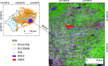
Fig. 1
The geographical location and the relief map of the study area and test area"

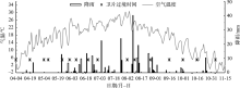
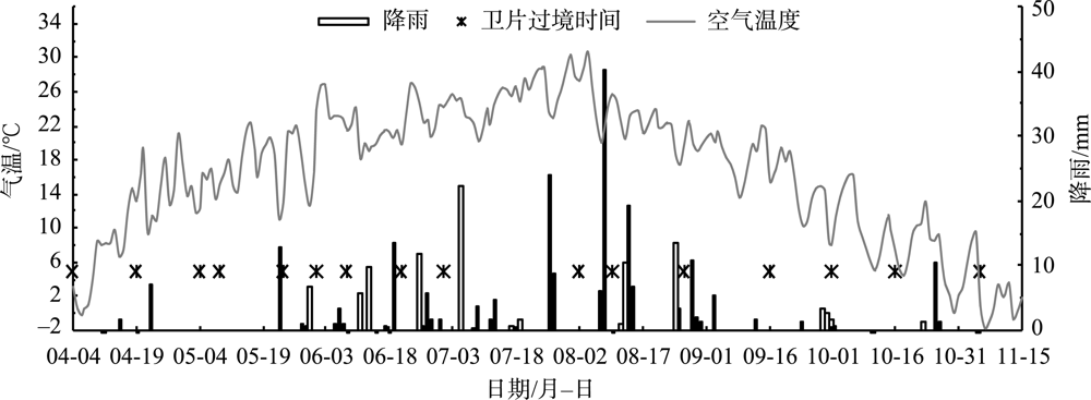
Fig. 2
Meteorological conditions and transit date of satellite in the test area of 2018"
Tab. 1
Statistical results of field data on land use/cover types"
| 土地利用/覆被类型 | 优势物种 | 调查点/个 | 植被种类(类) | 地上单位面积生物量/(g·m-2) | Shannon多样性指数(H) | 验证样本 |
|---|---|---|---|---|---|---|
| 草甸地 | 芦苇、苔草 | 6 | 9.17±4.95 | 438.65±340.23 | 1.51±0.68 | 125 |
| 流动沙地 | 沙米、差巴嘎蒿 | 5 | 6.33±1.6 | 107.35±58.08 | 1.09±0.31 | 55 |
| 低多样性半灌木群落 | 差巴嘎蒿 | 4 | 9.25±1.09 | 122.55±77.17 | 1.66±0.10 | 75 |
| 高多样性半灌木群落 | 冷蒿、麻黄、冰草 | 7 | 13.67±2.92 | 229.32±155.94 | 1.99±0.13 | 110 |
| 灌木群落 | 小叶锦鸡儿 | 16 | 13.88±4.57 | 1292.5±1367.16 | 1.81±0.25 | 130 |
| 乔木林 | 杨树 | 6 | - | - | - | 70 |
| 旱地 | 玉米 | 7 | - | - | - | 185 |
| 水田 | 水稻 | 3 | - | - | - | 25 |
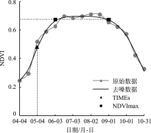
Fig. 3
The processed NDVI curves of single pixel about forest by Double Logistic filter"
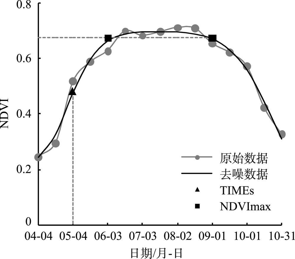
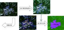
Fig. 4
Schematic diagram of village remote sensing interpretation steps"

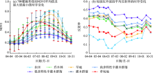
Fig. 5
Features of remote sensing inversion information of various types of cover"

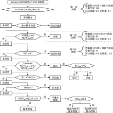
Fig. 6
Classification decision tree of land use/cover type in the study area"

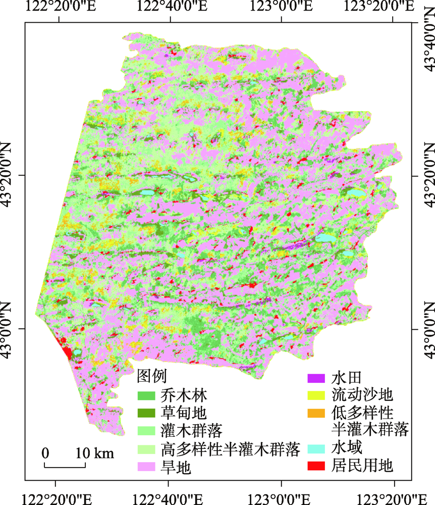
Fig. 7
Interpretation results of land use/cover types in the study area"
Tab. 2
Classification accuracy of study area"
| 乔木林 | 灌木 群落 | 低多样性 半灌木群落 | 高多样性 半灌木群落 | 草甸地 | 旱地 | 水田 | 流动 沙地 | 水域 | 居民 用地 | 用户 精度 | |
|---|---|---|---|---|---|---|---|---|---|---|---|
| 乔木林 | 60 | 0 | 0 | 0 | 25 | 0 | 0 | 0 | 0 | 0 | 0.71 |
| 灌木群落 | 10 | 130 | 0 | 28 | 0 | 10 | 0 | 0 | 0 | 0 | 0.73 |
| 低多样性半灌木群落 | 0 | 0 | 65 | 0 | 0 | 0 | 0 | 0 | 0 | 0 | 1 |
| 高多样性半灌木群落 | 0 | 0 | 5 | 82 | 0 | 0 | 0 | 0 | 0 | 0 | 0.94 |
| 草甸地 | 0 | 0 | 0 | 0 | 100 | 0 | 0 | 0 | 0 | 0 | 1 |
| 旱地 | 0 | 0 | 0 | 0 | 0 | 175 | 0 | 0 | 0 | 0 | 1 |
| 水田 | 0 | 0 | 0 | 0 | 0 | 0 | 25 | 0 | 0 | 0 | 1 |
| 流动沙地 | 0 | 0 | 5 | 0 | 0 | 0 | 0 | 55 | 0 | 0 | 0.92 |
| 水域 | 0 | 0 | 0 | 0 | 0 | 0 | 0 | 0 | 50 | 0 | 1 |
| 居民用地 | 0 | 0 | 0 | 0 | 0 | 0 | 0 | 0 | 0 | 75 | 1 |
| 制图精度 | 0.86 | 1 | 0.87 | 0.75 | 0.8 | 0.95 | 1 | 1 | 1 | 1 | |
| 总体分类精度 | 0.91 | ||||||||||
| Kappa系数 | 0.89 |
| [1] | Li J, Xu B, Yang X, et al. Historical grassland desertification changes in the Horqin Sandy Land, Northern China (1985-2013)[J]. Scientific Reports, 2017,7(3009):1-12. |
| [2] | Zhang G, Dong J, Xiao X, et al. Effectiveness of ecological restoration projects in Horqin Sandy Land, China based on SPOT-VGT NDVI data[J]. Ecological Engineering, 2012,38(1):20-28. |
| [3] |
Duan H, Wang T, Xue X, et al. Dynamics of aeolian desertification and its driving forces in the Horqin Sandy Land, Northern China[J]. Environ Monit Assess, 2014,186:6083-6096.
pmid: 24891073 |
| [4] | 那音太, 乌兰图雅, 秦福莹. 基于3S技术的科尔沁沙地土地荒漠化动态监测——以科尔沁左翼后旗为例[J]. 干旱区资源与环境, 2010,24(10):50-54. |
| [ Na Yintai, Wulan Tuya, Qin Fuying. Dynamic monitoring of Horqin sandy land desertification based on 3S techniques: A case study in Horqin Left Wing Banner[J]. Journal of Arid Land Resources and Environment, 2010,24(10):50-54. ] | |
| [5] | Zheng X, Zhu J J, Yan Q L, et al. Effects of land use changes on the groundwater table and the decline of Pinus sylvestris var. mongolica plantations in southern Horqin Sandy Land, Northeast China[J]. Agricultural Water Management, 2012,109:94-106. |
| [6] | 焦树仁. 辽宁省章古台樟子松固沙林提早衰退的原因与防治措施[J]. 林业科学, 2001,37(2):131-138. |
| [ Jiao Shuren. Report on the causes of the early decline of Pinus slyvestris var. Mongolica shelterbelt and its preventaive and control measures in Zhang Gutai of Liaoning Province[J]. Scientia Silvae Sinicae, 2001,37(2):131-138. ] | |
| [7] | Li X R, Xiao H L, Zhang J G, et al. Long-term ecosystem effects of sand-binding vegetation in the Shapotou Region of the Tengger Desert, Northern China[J]. Restoration Ecology, 2004,12(3):376-390. |
| [8] | 陈百明, 刘新卫, 杨红. LUCC 研究的最新进展评述[J]. 地理科学进展, 2003,22(1):22-29. |
| [ Chen Baiming, Liu Xingwei, Yang Hong. Review of most recent progresses of study on land use and land cover change[J]. Progress in Geography, 2003,22(1):22-29. ] | |
| [9] | Wang Y, Zhang J, Tong S, et al. Monitoring the trends of aeolian desertified lands based on time-series remote sensing data in the Horqin Sandy Land, China[J]. Catena, 2017,157:286-298. |
| [10] | He K S, Rocchini D, Neteler M, et al. Benefits of hyperspectral remote sensing for tracking plant invasions Divers[J]. Diversity and Distribution, 2011,17:381-392. |
| [11] | Vicente J, Randin C F, Gonçalves J, et al. Where will conflicts between alien and rare species occur after climate and land-use change? A test with a novel combined modelling approach[J]. Biological Invasions, 2011,13:1209-1227. |
| [12] | Rocchini D. Effects of spatial and spectral resolution in estimating ecosystem α-diversity by satellite imagery[J]. Remote Sensing Environment, 2007,111:423-434. |
| [13] | Nagendra H, Rocchini D, Ghate R, et al. Assessing plant diversity in a dry tropical forest: Comparing the utility of Landsat and IKONOS satellite images[J]. Remote Sensing, 2010,2(2):478-496. |
| [14] | Conese C, Maselli F. Use of multitemporal information to improve classification performance of TM scenes in complex terrain[J]. Remote Sensing, 1991,46:187-197. |
| [15] | Drusch M, Del Bello U, Carlier S, et al. Sentinel-2: ESA’s optical high-resolution mission for GMES operational services[J]. Remote Sensing Environment, 2012,120:25-36. |
| [16] | 田颖, 陈卓奇, 惠凤鸣, 等. 欧空局哨兵卫星Sentinel-2A/B数据特征及应用前景分析[J]. 北京师范大学学报(自然科学版), 2019,55(1):57-65. |
| [ Tian Ying, Chen Zhuoqi, Hui Fengming, et al. ESA Sentinel-2A/B satellite: Characteristics and applications[J]. Journal of Beijing Normal University(Natural Science Edition), 2019,55(1):57-65. ] | |
| [17] | 黄天宇, 王冠丽, 李东方, 等. 科尔沁沙地沙丘——草甸梯级生态系统不同气象条件下气候学足迹特征[J]. 干旱区研究, 2019,36(5):1127-1135. |
| [ Huang Tianyu, Wang Guanli, Li Dongfang, et al. Climatological footprints in dune-meadow cascade ecosystem under different meteorological conditions in the Horqin Sandy Land[J]. Arid Zone Research, 2019,36(5):1127-1135. ] | |
| [18] | Müller-Wilm, U. Sen2Cor 2. 5. 5—Software Release Note[EB/OL]. https://step.esa.int/main/new-release-of-sen2cor-2-5-5, 2019-2-4. |
| [19] | Hutchings M J. Weight-density relationships in ramet populations of clonal perennial herbs, with special reference to the -3/2 power law[J]. Journal of Ecology, 1979,67(1):21-33. |
| [20] | Shannon C E. A mathematica theory of communication[J]. Bell System Technical Journal, 1948,27(3):479-523. |
| [21] | 曹文梅, 刘小燕, 王冠丽, 等. 科尔沁沙地自然植被与生境因子的MRT分类及DCCA分析[J]. 生态学杂志, 2017,36(2):318-327. |
| [ Cao Wenmei, Liu Xiaoyan, Wang Guanli, et al. Combined analyses of MRT and DCCA on relationships between plant community distribution and ecological factors of Horqin Sandy Land[J]. Chinese Journal of Ecology, 2017,36(2):318-327. ] | |
| [22] | 包永志, 刘廷玺, 段利民, 等. 科尔沁沙地混生小叶锦鸡儿和人工杨树光合特性及其对气候的响应[J]. 干旱区研究, 2019,36(2):420-429. |
| [ Bao Yongzhi, Liu Tingxi, Duan Limin, et al. Photosynthetic traits of Caragana microphylla and Populus spp. and their responses to climate in the Horqin Sandy Land[J]. Arid Zone Research, 2019,36(2):420-429. ] | |
| [23] | Benz U C, Hofmann P, Willhauck G, et al. Multi-resolution, object-oriented fuzzy analysis of remote sensing data for GIS-ready information[J]. SPRS Journal of Photogrammetry & Remote Sensing, 2004,58:239-258. |
| [24] | Trimble Germany Gmb H. eCognition Developer 8. 9 User Guide[EB/OL]. Trimble Germany GmbH, Munich, Germany, 2013. |
| [25] | 滑永春, 李增元, 高志海. 面向对象分割与混合像元分解相结合提取沙化土地信息[J]. 干旱区研究, 2020,37(5):1346-1352. |
| [ Hua Yongchun, Li Zengyuan, Gao Zhihai. Extraction of sand information using object-oriented segmentation combined with decomposition of mixed pixels[J]. Arid Zone Research, 2020,37(5):1346-1352. ] | |
| [26] | 邬亚娟, 刘廷玺, 童新, 等. 基于面向对象的干旱半干旱地区植被分类[J]. 干旱区研究, 2020,37(4):1026-1034. |
| [ Wu Yajuan, Liu Tingxi, Tong Xin, et al. Vegetation classification in arid and semi-arid areas using an object-oriented method[J]. Arid Zone Research, 2020,37(4):1026-1034. ] | |
| [27] | Drǎgu L, Csillik O, Eisank C, et al. Automated parameterisation for multi-scale image segmentation on multiple layers[J]. ISPRS Journal Photogramm Remote Sensing, 2014,88(100):119-127. |
| [28] | Beck P S A, Atzberger C, Høgda K A, et al. Improved monitoring of vegetation dynamics at very high latitudes: A new method using MODIS NDVI[J]. Remote Sensing of Environment, 2006,99:321-334. |
| [29] | Jönsson P, Eklundh L. TIMESAT: A program for analyzing time-series of satellite sensor data[J]. Computers & Geosciences, 2004,30:833-845. |
| [30] | 李苗苗. 植被覆盖度的遥感估算方法研究[D]. 北京: 中国科学院, 2003. |
| [ Li Miaomiao. The Study on Remote Sensing Estimation Method of Vegetation Coverage[D]. Beijing: Chinese Academy of Sciences, 2003. ] | |
| [31] | 王永芳, 张继权, 马齐云, 等. 21 世纪初科尔沁沙地沙漠化对区域气候变化的响应[J]. 农业工程学报, 2016,32(2):177-185. |
| [ Wang Yongfang, Zhang Jiquan, Ma Qiyun, et al. Response of aeolian desertification to regional climate change in Horqinsandy land at beginning of 21st century[J]. Transactions of the Chinese Society of Agricultural Engineering, 2016,32(2):177-185. ] | |
| [32] | 史小红, 李畅游, 刘廷玺. 科尔沁沙地坨甸相间地区土壤水分空间分布特性分析[J]. 中国沙漠, 2007,27(5):837-842. |
| [ Shi Xiaohong, Li Changyou, Liu Tingxi. Analysis on spatial characteristics of soil water in marshland-dune areas in Horqin Sandy Land[J]. Journal of desert research, 2007,27(5):837-842. ] | |
| [33] | 汪求来. 面向对象遥感影像分类方法及其应用研究[D]. 南京: 南京林业大学, 2008. |
| [ Wang Qiulai. Study on Object-Oriented Romote Sensing Image Classification and Its Application-Taking Urban Vegetation Extraction in Futian, Shenzhen City for Example[D]. Nanjing: Nanjing Forestry University, 2008. ] | |
| [34] | 张继义, 赵哈林, 张铜会, 等. 科尔沁沙地植物群落恢复演替系列种群生态位动态特征[J]. 生态学报, 2003,23(12):2741-2746. |
| [ Zhang Jiyi, Zhao Haling, Zhang Tonghui, et al. Niche dynamics of main populations of plants communities in the restoring succession process in Horqin Sand Land[J]. Acta Ecologica Sinica, 2003,23(12):2741-2746. ] |
| [1] | WANG Yiwen, MA Yaoyao, SHI Peijun, ZHANG Gangfeng. The impact of photovoltaic power plant operation on local ecological environments in arid areas [J]. Arid Zone Research, 2024, 41(8): 1423-1433. |
| [2] | MA Yuanzhi, QIN Xiaolin, LING Hongbo, YAN Junjie, ZHANG Guangpeng. Spatio-temporal characteristics and trends of area changes in the small and medium-sized lakes in Xinjiang, China, from 1991 to 2020 [J]. Arid Zone Research, 2024, 41(6): 905-916. |
| [3] | HONG Guojun, XIE Junbo, ZHANG Ling, FAN Zhenqi, YU Caili, FU Xianbing, LI Xu. Monitoring soil salinization of cotton fields in the Aral Reclamation Area using multispectral imaging [J]. Arid Zone Research, 2024, 41(5): 894-904. |
| [4] | ZHANG Hua, YA Haiting, XU Cungang. Remote sensing retrieval of soil moisture and estimation of vegetation water requirements in the north and south mountains of Lanzhou City [J]. Arid Zone Research, 2024, 41(4): 566-580. |
| [5] | YAO Jinxi, XIAO Chengzhi, ZHANG Zhi, WANG Lang, ZHANG Kun. Vegetation feature type extraction in arid regions based on GEE multi-source remote sensing data [J]. Arid Zone Research, 2024, 41(1): 157-168. |
| [6] | LIU Yidan, YAO Xiaojun, LI Zongxing, HU Jiayu. Impacts of climate change and land use/cover change on the net primary productivity of vegetation in Hexi Region, Northwest China [J]. Arid Zone Research, 2024, 41(1): 169-180. |
| [7] | ZHU Congzhen,ZHAO Tianliang,MENG Lu,YANG Xinghua,HE Qing,Ali MAMTIMIN. Objective weather classification of persistent floating dust weather in the Tarim Basin [J]. Arid Zone Research, 2023, 40(9): 1391-1403. |
| [8] | MA Yaoyao, SHI Peijun, XU Wei, ZHANG Gangfeng. Remote sensing monitoring of the ecological environment of hydropower station construction and operation in arid areas: A case study of Longyangxia Hydropower Station [J]. Arid Zone Research, 2023, 40(9): 1498-1508. |
| [9] | MENG Chengfeng, ZHONG Tao, ZHENG Jianghua, WANG Nan, LIU Zexuan, REN Xiangyuan. Analysis of temporal and spatial characteristics and driving forces of Kunlun glacial lakes [J]. Arid Zone Research, 2023, 40(7): 1094-1106. |
| [10] | LIU Xiao, GUO Peng, QI Jiafeng, DU Wenling, ZHANG Ruqian, ZHANG Kun. Spatio-temporal changes and driving forces in the ecological environment of Altay City determined using an MRSEI model [J]. Arid Zone Research, 2023, 40(6): 1014-1026. |
| [11] | JIJI Jiamen, CHENG Yiben, CHEN Linglong, WAN Pengxiang, ZHANG Yihui, YANG Wenbin, BAI Xuying, WANG Tao. Dynamic changes in soil moisture and its response to rainfall in Pinus sylvestris var. mongolica plantation in Horqin Sandy Land [J]. Arid Zone Research, 2023, 40(5): 756-766. |
| [12] | MA Haowen, WANG Yongfang, GUO Enliang. Remote sensing monitoring of aeolian desertification in Ongniud Banner based on GEE [J]. Arid Zone Research, 2023, 40(3): 504-516. |
| [13] | WU Rui, CAO Hongyu, GAO Guanglei, YU Minghan, DING Guodong, ZHANG Ying, ZHAO Peishan. Effects of irrigation and salinity treatments on the soil bacterial community and plant physiological characteristics of Cyperus esculentus farmland in Horqin Sandy Land [J]. Arid Zone Research, 2023, 40(12): 1938-1948. |
| [14] | XIAO Sentian, Ilyas NURMEMET, Nuerbiye MUHETAER, Zhao Jing, Adilai ABULAITI. Spatial and temporal analysis of soil salinity in Yutian Oasis by combined optical and radar multi-source remote sensing [J]. Arid Zone Research, 2023, 40(1): 59-68. |
| [15] | PANG Haiwei,YU Dian,REN Chengbao,ZHANG Yu,ZHENG Caizhi,GUO Jiacheng,BIAN Zhen,SANG Guoqing. Remote sensing classification characteristics of typical plant communities in the semi-arid areas of eastern Ningxia [J]. Arid Zone Research, 2022, 39(6): 1930-1941. |
|
||