Arid Zone Research ›› 2023, Vol. 40 ›› Issue (3): 504-516.doi: 10.13866/j.azr.2023.03.16
• Ecology and Environment • Previous Articles
MA Haowen1,2( ),WANG Yongfang1,2,3(),GUO Enliang1,2
Received:2022-06-09
Revised:2022-08-10
Online:2023-03-15
Published:2023-03-31
MA Haowen, WANG Yongfang, GUO Enliang. Remote sensing monitoring of aeolian desertification in Ongniud Banner based on GEE[J].Arid Zone Research, 2023, 40(3): 504-516.
Add to citation manager EndNote|Reference Manager|ProCite|BibTeX|RefWorks
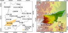
Fig. 1
Study area schematic"

Tab. 1
Introduction to driver factor raster data"
| 驱动因子 | 分辨率 | 时间范围 | 数据名称 | 数据来源 |
|---|---|---|---|---|
| 海拔 | 900 m | 2000年 | GMTED 2010 | https://www2.jpl.nasa.gov/srtm/ |
| 坡度 | 900 m | 2000年 | ||
| 坡向 | 900 m | 2000年 | ||
| 气温 | 0.042° | 1991—2015年 | Terra Climate[ | https://climate.northwestknowledge.net/ |
| 降水量 | 0.042° | 1991—2015年 | ||
| 潜在蒸散量 | 0.042° | 1991—2015年 | ||
| 风速 | 0.042° | 1991—2015年 | ||
| 土壤湿度 | 0.042° | 1991—2015年 | ||
| 土壤类型 | 900 m | 2000年 | 中国土壤类型空间分布数据 | https://www.resdc.cn/DOI/ |
| 人口 | 1 km | 1995年,2010年 | 中国人口空间分布公里网格数据 | https://www.resdc.cn/DOI/ |
| GDP | 1 km | 1995年,2010年 | 中国GDP空间分布公里网格数据 | https://www.resdc.cn/DOI/ |
| 牲畜数量 | 0.083° | 2010年 | 粮农组织牲畜系统[ | https:// www.fao.org/livestock-systems/ |
Tab. 2
Dynamic changes of aeolian desertification land area in Ongniud Banner"
| 1991年 | 2000年 | 2015年 | 1991—2000年 | 2000—2015年 | ||||||||||
|---|---|---|---|---|---|---|---|---|---|---|---|---|---|---|
| 面积 /km2 | 比例 /% | 面积 /km2 | 比例 /% | 面积 /km2 | 比例 /% | 面积变化 /km2 | 动态度/% | 面积变化 /km2 | 动态度/% | |||||
| 非沙化 | 4820.17 | 40.72 | 2722.79 | 22.94 | 6104.75 | 51.36 | -2097.38 | -4.8 | 3381.96 | 8.3 | ||||
| 轻度 | 1545.47 | 13.06 | 1135.12 | 9.56 | 1398.46 | 11.76 | -410.35 | -3.0 | 263.34 | 1.5 | ||||
| 中度 | 1767.07 | 14.93 | 2345.36 | 19.76 | 1807.44 | 15.20 | 578.29 | 3.6 | -537.92 | -1.5 | ||||
| 重度 | 1754.52 | 14.82 | 3255.94 | 27.43 | 1667.82 | 14.03 | 1501.42 | 9.5 | -1588.12 | -3.3 | ||||
| 极重度 | 1950.46 | 16.47 | 2411.39 | 20.31 | 909.48 | 7.65 | 460.93 | 2.6 | -1501.91 | -4.2 | ||||

Fig. 2
Temporal and spatial changes of aeolian desertification land in Ongniud Banner"
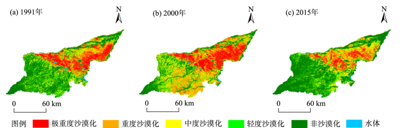

Fig. 3
Changes of aeolian desertification land transfer in Ongniud Banner"

Tab. 3
q values of factor detector"
| 土壤类型 | 土壤湿度 | 海拔 | 降水量 | 气温 | 坡度 | 风速 | 人口 | 牲畜数量 | GDP | 坡向 | 潜在蒸散量 | |
|---|---|---|---|---|---|---|---|---|---|---|---|---|
| 1991—2000年 | 0.153* | 0.124* | 0.122* | 0.121* | 0.095* | 0.093* | 0.086* | 0.081* | 0.05 | 0.035 | 0.02 | 0.026 |
| 2000—2015年 | 0.082 | 0.069* | 0.071 | 0.103* | 0.099* | 0.068* | 0.053 | 0.04 | 0.069 | 0.042 | 0.047 | 0.056 |
Fig. 4
Dynamic changes of driving factors of desertification in Ongniud Banner"

Fig. 5
NDVI and Albedo changes in Ongniud Banner"

| [1] | 胡云锋, 张云芝, 韩月琪. 2000—2015年中国荒漠化土地识别和监测[J]. 干旱区地理, 2018, 41(6): 1321-1332. |
| [Hu Yunfeng, Zhang Yunzhi, Han Yueqi. Identification and monitoring of desertification lands in China from 2000 to 2015[J]. Arid Land Geography, 2018, 41(6): 1321-1332.] | |
| [2] | 阿如旱, 都来, 盛艳, 等. 基于Logistic回归模型的内蒙古多伦县土地沙漠化驱动力分析[J]. 干旱区地理, 2019, 42(1): 137-143. |
| [Aruhan, Du Lai, Sheng Yan, et al. Driving forces on land desertification in Duolun County Inner Mongolia based on logistic regress model[J]. Arid Land Geography, 2019, 42(1): 137-143.] | |
| [3] | 王涛. 我国沙漠化研究的若干问题——3. 沙漠化研究和防治的重点区域[J]. 中国沙漠, 2004, 24(1): 1-9. |
| [Wang Tao. Study on sandy desertification in China: 3. Key regions for studying and combating sandy desertification[J]. Journal of Desert Research, 2004, 24(1): 1-9.] | |
| [4] | 李金亚. 科尔沁沙地草原沙化时空变化特征遥感监测及驱动力分析[D]. 北京: 中国农业科学院, 2014. |
| [Li Jinya. Spatio-temporal Variations and Its Driving Factors of the Grassland Sandy Desertification in Horqin Sandy Land Based on Remote Sensing[D]. Beijing: Chinese Academy of Agricultural Sciences, 2014.] | |
| [5] | 王娟, 李宝林, 余万里. 近30年内蒙古自治区植被变化趋势及影响因素分析[J]. 干旱区资源与环境, 2012, 26(2): 132-138. |
| [Wang Juan, Li Baolin, Yu Wanli. Analysis of vegetation trend and their causes during recent 30 years in Inner Mongolia Autonomous Region[J]. Journal of Arid Land Resources and Environment, 2012, 26(2): 132-138.] | |
| [6] | 牛存洋, 阿拉木萨, 刘亚, 等. 科尔沁沙地固沙植物根系与土壤水分特征研究[J]. 干旱区资源与环境, 2015, 29(10): 106-111. |
| [Niu Cunyang, Alamusa, Liu Ya, et al. The characteristics of sand-fixation plantations roots and soil moisture in Horqin Sandy Land[J]. Journal of Arid Land Resources and Environment, 2015, 29(10): 106-111.] | |
| [7] | 郭翠萍, 郭浩, 霍俊澎, 等. 中国主要沙漠和沙地碳同位素特征[J]. 干旱区资源与环境, 2020, 34(2): 135-140. |
| [Guo Cuiping, Guo Hao, Huo Junpeng, et al. Carbon isotope characteristics of deserts and sandy lands in China[J]. Journal of Arid Land Resources and Environment, 2020, 34(2): 135-140.] | |
| [8] | 康文平, 刘树林. 沙漠化遥感监测与定量评价研究综述[J]. 中国沙漠, 2014, 34(5): 1222-1229. |
| [Kang Wenping, Liu Shulin. A review of remote sensing monitoring and quantitative assessment of aeolian desertification[J]. Journal of Desert Research, 2014, 34(5): 1222-1229.] | |
| [9] | 王永芳. 基于多源数据融合与DPSIR模型的科尔沁沙地沙漠化生态风险评价[D]. 长春: 东北师范大学, 2016. |
| [Wang Yongfang. Ecological Risk Assessment on Aeolian Desertification in Horqin Sandy Land Using Multi-source Data Fusion and DPSIR Model[D]. Changchun: Northeast Normal University, 2016.] | |
| [10] | 白壮壮, 崔建新, 丁晓辉. 1986—2015年鄂尔多斯高原沙漠化及其驱动因素研究[J]. 干旱区研究, 2020, 37(3): 749-756. |
| [Bai Zhuangzhuang, Cui Jianxin, Ding Xiaohui. Desertification and its driving factors in the Ordos Plateau, from 1986 to 2015[J]. Arid Zone Research, 2020, 37(3): 749-756.] | |
| [11] | 黄伟, 张懿, 王利明. 基于TM影像的土地荒漠化变化研究——以巴彦淖尔地区为例[J]. 内蒙古林业调查设计, 2015, 38(5): 132-134. |
| [Huang Wei, Zhang Yi, Wang Liming. Desertification change based on TM image: A case study of Bayannur Region[J]. Inner Mongolia Forestry Investigation and Design, 2015, 38(5): 132-134.] | |
| [12] | 岳喜元, 常学礼, 刘良旭, 等. 科尔沁沙地植被NDVI对太阳辐射照度变化的响应机制[J]. 干旱区资源与环境, 2015, 29(3): 98-102. |
| [Yue Xiyuan, Chang Xueli, Liu Liangxu, et al. The responding mechanism of NDVI to solar radiation intensity change in Horqin Sandy Land[J]. Journal of Arid Land Resources and Environment, 2015, 29(3): 98-102.] | |
| [13] | 于显双, 赵明, 陈凤臻, 等. 基于GIS的北方农牧交错带荒漠化遥感动态监测与成因分析——以内蒙古通辽市为例[J]. 干旱区资源与环境, 2010, 24(4): 107-111. |
| [Yu Xianshuang, Zhao Ming, Chen Fengzhen, et al. Dynamic remote sensing monitoring and analysis on desertification in the northern farming: Pastoral zone based on GIS[J]. Journal of Arid Land Resources and Environment, 2010, 24(4): 107-111.] | |
| [14] | 那音太, 乌兰图雅, 秦福莹. 基于3S技术的科尔沁沙地土地荒漠化动态监测——以科尔沁左翼后旗为例[J]. 干旱区资源与环境, 2010, 24(10): 50-54. |
| [Na Yintai, Wulan Tuya, Qin Fuying. Dynamic monitoring of Horqin sandy land desertification based on 3S techniques: A case study in Horqin Left Wing Banner[J]. Journal of Arid Land Resources and Environment, 2010, 24(10): 50-54.] | |
| [15] | 段英杰, 何政伟, 王永前, 等. 基于遥感数据的西藏自治区土地沙漠化监测分析研究[J]. 干旱区资源与环境, 2014, 28(1): 55-61. |
| [Duan Yingjie, He Zhengwei, Wang Yongqian, et al. Monitoring land desertification of Tibet Autonomous Region based on remote sensing[J]. Journal of Arid Land Resources and Environment, 2014, 28(1): 55-61.] | |
| [16] |
曾永年, 向南平, 冯兆东, 等. Albedo-NDVI特征空间及沙漠化遥感监测指数研究[J]. 地理科学, 2006, 26(1): 75-81.
doi: 10.13249/j.cnki.sgs.2006.01.75 |
|
[Zeng Yongnian, Xiang Nanping, Feng Zhaodong, et al. Albedo-NDVI space and remote sensing synthesis index models for desertification monitoring[J]. Scientia Geographica Sinica, 2006, 26(1): 75-81.]
doi: 10.13249/j.cnki.sgs.2006.01.75 |
|
| [17] | 岳辉, 刘英. 基于NDVI-Albedo特征空间的陕西省干旱与荒漠化遥感监测[J]. 西北林学院学报, 2019, 34(1): 198-205. |
| [Yue Hui, Liu Ying. Remote sensing monitoring of drought and desertification in Shaanxi Province based on NDVI-Albedo feature space[J]. Journal of Northwest Forestry University, 2019, 34(1): 198-205.] | |
| [18] | 王家琪. 内蒙古赤峰及其周边地区荒漠化变化趋势研究——基于遥感技术中反照率和归一化植被指数特征空间[J]. 安徽农业科学, 2016, 44(27): 217-219. |
| [Wang Jiaqi. Study on the change trend of desertification in Chifeng and its surrounding areas: Based on albedo and normalized vegetation index feature space in remote sensing technology[J]. Journal of Anhui Agricultural Sciences, 2016, 44(27): 217-219.] | |
| [19] | 任艳群, 刘海隆, 唐立新, 等. 基于NDVI-Albedo特征空间的沙漠化动态变化研究——以准格尔盆地南缘为例[J]. 水土保持通报, 2014, 34(2): 267-271. |
| [Ren Yanqun, Liu Hailong, Tang Lixin, et al. A study on dynamic changes of desertification in south edge of Junggar Basin based on NDVI-Albedo features[J]. Bulletin of Soil and Water Conservation, 2014, 34(2): 267-271.] | |
| [20] |
王劲峰, 徐成东. 地理探测器: 原理与展望[J]. 地理学报, 2017, 72(1): 116-134.
doi: 10.11821/dlxb201701010 |
|
[Wang Jinfeng, Xu Chengdong. Geodetector: Principle and prospective[J]. Acta Geographica Sinica, 2017, 72(1): 116-134.]
doi: 10.11821/dlxb201701010 |
|
| [21] |
王晓峰, 张明明, 尹礼唱, 等. 2000—2015年中国干旱半干旱地区沙漠化进程驱动力研究[J]. 生态环境学报, 2019, 28(5): 948-957.
doi: 10.16258/j.cnki.1674-5906.2019.05.011 |
|
[Wang Xiaofeng, Zhang Mingming, Yin Lichang, et al. Study on the driving factors in desertification process in arid and semi-arid region of China from 2000 to 2015[J]. Ecology and Environmental Sciences, 2019, 28(5): 948-957.]
doi: 10.16258/j.cnki.1674-5906.2019.05.011 |
|
| [22] | 王嘉妮, 陈海, 史琴琴, 等. 陕西省县域土地利用多功能性时空分异及影响因素研究[J]. 中国农业资源与区划, 2019, 40(5): 101-108. |
| [Wang Jiani, Chen Hai, Shi Qinqin, et al. Research on spatial-temporal differentiation and influencing factors of land use multi-functionality in County Areas of Shaanxi Province[J]. Chinese Journal of Agricultural Resources and Regional Planning, 2019, 40(5): 101-108.] | |
| [23] | 常亚斌, 朱睿, 肖生春, 等. 1980—2015年阿拉善盟沙地面积变化及其驱动因子[J]. 中国沙漠, 2020, 40(6): 82-90. |
| [Chang Yabin, Zhu Rui, Xiao Shengchun, et al. Sandy land change from 1980 to 2015 in Alxa League, China and its driving factors[J]. Journal of Desert Research, 2020, 40(6): 82-90.] | |
| [24] | 席文涛, 高晶. 基于地理探测器分析青藏高原降水δ18O空间分异特征[J]. 干旱区研究, 2021, 38(5): 1199-1206. |
| [Xi Wentao, Gao Jing. Spatial heterogentity of annual precipitation δ18O over the Tibetan Plateau based on the use of a geographical detector[J]. Arid Zone Research, 2021, 38(5): 1199-1206.] | |
| [25] | 连杰, 赵学勇, 左小安, 等. 科尔沁沙地水域景观格局的时空动态——以奈曼旗为例[J]. 中国沙漠, 2012, 32(1): 210-218. |
| [Lian Jie, Zhao Xueyong, Zuo Xiao’an, et al. Dynamics of landscape pattern of water areas in Horqin Sandy Land, China: A case study in Naiman Banner of Inner Mongolia[J]. Journal of Desert Research, 2012, 32(1): 210-218.] | |
| [26] | 岳喜元, 左小安, 赵学勇, 等. 科尔沁沙地沙漠化风险评价[J]. 中国沙漠, 2018, 38(1): 8-16. |
| [Yue Xiyuan, Zuo Xiao’an, Zhao Xueyong, et al. Desertification risk assessment in Horqin Sandy Land[J]. Journal of Desert Research, 2018, 38(1): 8-16.] | |
| [27] | 吕家欣, 李秀芬, 郑晓, 等. 近40年科尔沁沙地植被时空变化及其驱动力[J]. 生态学杂志, 2020, 39(5): 1399-1408. |
| [Lv Jiaxin, Li Xiufen, Zheng Xiao, et al. Temporal and spatial changes and their driving forces of vegetation cover in Horqin Sandy Land in recent 40 years[J]. Chinese Journal of Ecology, 2020, 39(5): 1399-1408.] | |
| [28] |
Abatzoglou J T, Dobrowski S Z, Parks S A, et al. Terra Climate, a high-resolution global dataset of monthly climate and climatic water balance from 1958-2015[J]. Scientific Data, 2018, 5: 170191.
doi: 10.1038/sdata.2017.191 |
| [29] | Liu H, Jiang D, Yang X, et al. Spatialization approach to 1 km Grid GDP supported by Remote Sensing[J]. Geo-information Science, 2005, 7(2): 120-123. |
| [30] | 徐涵秋. 利用改进的归一化差异水体指数(MNDWI)提取水体信息的研究[J]. 遥感学报, 2005, 9(5): 589-595. |
| [Xu Hanqiu. A study on information extraction of water body with the modified normalized water index (MNDWI)[J]. Journal of Remote Sensing, 2005, 9(5): 589-595.] | |
| [31] |
Liang S, Shuey C J, Russ A L, et al. Narrowband to broadband conversions of land surface albedo: II. Validation[J]. Remote Sensing of Environment, 2003, 84(1): 25-41.
doi: 10.1016/S0034-4257(02)00068-8 |
| [32] |
Liang S. Narrowband to broadband conversions of land surface albedo I algorithms[J]. Remote Sensing of Environment, 2001, 76(2): 213-238.
doi: 10.1016/S0034-4257(00)00205-4 |
| [33] | Duan H C, Wang T, Xue X, et al. Dynamics of aeolian desertification and its driving forces in the Horqin Sandy Land, Northern China[J]. Environmental Monitoring & Assessment, 2014, 186(10): 6083-6096. |
| [34] |
Duan H C, Wang T, Xue X, et al. Dynamic monitoring of aeolian desertification based on multiple indicators in Horqin Sandy Land, China[J]. Science of The Total Environment, 2019, 650: 2374-2388.
doi: 10.1016/j.scitotenv.2018.09.374 |
| [35] | Wang J, Hu Y. Environmental health risk detection with GeogDetector[J]. Environmental Modelling & Software, 2012, 33: 114-115. |
| [36] |
Wang J F, Li X H, Christakos G, et al. Geographical detectors-based health risk assessment and its application in the neural tube defects study of the Heshun Region, China[J]. International Journal of Geographical Information Science, 2010, 24(1): 107-127.
doi: 10.1080/13658810802443457 |
| [37] | Song Y, Wang J, Ge Y, et al. An optimal parameters-based geographical detector model enhances geographic characteristics of explanatory variables for spatial heterogeneity analysis: Cases with different types of spatial data[J]. GIScience & Remote Sensing, 2020, 57(5): 1760434. |
| [38] | 胡光印, 董治宝, 逯军峰, 等. 黄河流域沙漠化空间格局与成因[J]. 中国沙漠, 2021, 41(4): 213-224. |
| [Hu Guangyin, Dong Zhibao, Lu Junfeng, et al. Spatial pattern of aeolian desertification and its causes in the Yellow River catchment[J]. Journal of Desert Research, 2021, 41(4): 213-224.] | |
| [39] | 段翰晨, 薛娴. 基于DEM的科尔沁沙地沙漠化土地时空分布特征[J]. 干旱区资源与环境, 2018, 32(8): 74-79. |
| [Duan Hanchen, Xue Xian. Spatio-temporal distribution of aeolian desertification in Horqin Sandy Land based on DEM[J]. Journal of Arid Land Resources and Environment, 2018, 32(8): 74-79.] | |
| [40] | 郭茵, 雷加强, 范敬龙, 等. 近20 a蒙古国土壤风蚀变化特征及主要影响因素分析[J]. 干旱区研究, 2022, 39(4): 1200-1211. |
| [Guo Yin, Lei Jiaqiang, Fan Jinglong, et al. Soil wind erosion characteristics and main influencing factors in Mongolia in recent 20 years[J]. Arid Zone Research, 2022, 39(4): 1200-1211.] | |
| [41] | 王旭东, 陈秀芳, 敖东. 荒漠化防治开启“翁牛特模式”[J]. 内蒙古林业, 2015, 60(1): 8. |
| [Wang Xudong, Chen Xiufang, Ao Dong. “Ongniud Model” for desertification prevention and control[J]. Inner Mongolia Forestry, 2015, 60(1): 8.] | |
| [42] | 朱孟娜, 韩广, 郭宇航. 近10年来翁牛特旗土地沙漠化动态特征及其成因分析[J]. 湖南师范大学自然科学学报, 2016, 39(5): 16-21. |
| [Zhu Mengna, Han Guang, Guo Yuhang. Analysis on dynamic characteristics and reasons of land desertification in Wengniut Banner in Recent 10 Years[J]. Journal of Natural Science of Hunan Normal University, 2016, 39(5): 16-21.] | |
| [43] | 马秀梅. 赤峰市树立防沙治沙与绿色富民典型[J]. 内蒙古林业, 2020, 65(7): 8-13. |
| [Ma Xiumei. Chifeng to establish a model of sand control and green prosperity[J]. Inner Mongolia Forestry, 2020, 65(7): 8-13.] | |
| [44] | 段翰晨, 王涛, 薛娴, 等. 基于RS与GIS的科尔沁沙地沙漠化时空演变[J]. 中国沙漠, 2013, 33(2): 470-477. |
| [Duan Hanchen, Wang Tao, Xue Xian, et al. Spatial-temporal evolution of aeolian desertification in the Horqin Sandy Land based on RS and GIS[J]. Journal of Desert Research, 2013, 33(2): 470-477.] | |
| [45] | 王旭, 刁兆岩, 郑志荣, 等. 中蒙毗邻草原区荒漠化时空动态研究[J]. 环境科学研究, 2021, 34(12): 2935-2944. |
| [Wang Xu, Diao Zhaoyan, Zheng Zhirong, et al. Temporal and spatial dynamics of desertification in adjacent steppe of China and Mongolia[J]. Research of Environmental Sciences, 2021, 34(12): 2935-2944.] | |
| [46] | 杨军, 程玉琴, 尤莉. 翁牛特旗玉米生育期与气象条件的相关分析[J]. 内蒙古气象, 2014, 38(5): 33-35, 65. |
| [Yang Jun, Cheng Yuqin, You Li. Correlation analysis on corn growth period and meteorological conditions in Ongniud Banner[J]. Meteorology Journal of Inner Mongolia, 2014, 38(5): 33-35, 65.] | |
| [47] |
张丽, 杨国范, 刘吉平. 1986—2012年抚顺市土地利用动态变化及热点分析[J]. 地理科学, 2014, 34(2): 185-191.
doi: 10.13249/j.cnki.sgs.2014.02.185 |
|
[Zhang Li, Yang Guofan, Liu Jiping. The cynamic changes and hot spots of land use in Fushun City from 1986 to 2012[J]. Scientia Geographica Sinica, 2014, 34(2): 185-191.]
doi: 10.13249/j.cnki.sgs.2014.02.185 |
| [1] | HOU Jiaye, LI Jianhua, WANG Jiarong, MA Haitao, QIANG Zekai, FAN Xingang. The evolution of ecological quality in Yanchi County based on the SA-RSEI model [J]. Arid Zone Research, 2024, 41(6): 1045-1058. |
| [2] | CHENG Qiulian, LIU Jie, YANG Zhiwei, ZHANG Tianyi, WANG Bin. Spatial distribution and factor analysis of avalanche in the Aerxiangou section of the Duku expressway [J]. Arid Zone Research, 2024, 41(2): 220-229. |
| [3] | WANG Sinan, WU Yingjie, WANG Hongzhou, LI Mingyang, WANG Fei, ZHANG Wenying, MA Xiaoming, YU Xiangqian. Spatial and temporal drivers of drought analysis using the geodetector in Ordos [J]. Arid Zone Research, 2024, 41(12): 1981-1991. |
| [4] | MENG Chengfeng, ZHONG Tao, ZHENG Jianghua, WANG Nan, LIU Zexuan, REN Xiangyuan. Analysis of temporal and spatial characteristics and driving forces of Kunlun glacial lakes [J]. Arid Zone Research, 2023, 40(7): 1094-1106. |
| [5] | LIU Xiao, GUO Peng, QI Jiafeng, DU Wenling, ZHANG Ruqian, ZHANG Kun. Spatio-temporal changes and driving forces in the ecological environment of Altay City determined using an MRSEI model [J]. Arid Zone Research, 2023, 40(6): 1014-1026. |
| [6] | JIJI Jiamen, CHENG Yiben, CHEN Linglong, WAN Pengxiang, ZHANG Yihui, YANG Wenbin, BAI Xuying, WANG Tao. Dynamic changes in soil moisture and its response to rainfall in Pinus sylvestris var. mongolica plantation in Horqin Sandy Land [J]. Arid Zone Research, 2023, 40(5): 756-766. |
| [7] | LI Xinlei, LI Ruiping, WANG Xiuqing, WANG Sinan, WANG Chengkun. Spatiotemporal change and analysis of factors driving forest-grass vegetation coverage in Hetao Irrigation District based on geographical detector [J]. Arid Zone Research, 2023, 40(4): 623-635. |
| [8] | WANG Peng, QIN Sitong, HU Huirong. Spatial-temporal evolution characteristics of land use change and habitat quality in the Lhasa River Basin over the past three decades [J]. Arid Zone Research, 2023, 40(3): 492-503. |
| [9] | WU Rui, CAO Hongyu, GAO Guanglei, YU Minghan, DING Guodong, ZHANG Ying, ZHAO Peishan. Effects of irrigation and salinity treatments on the soil bacterial community and plant physiological characteristics of Cyperus esculentus farmland in Horqin Sandy Land [J]. Arid Zone Research, 2023, 40(12): 1938-1948. |
| [10] | XI Wentao,GAO Jing. Spatial heterogeneity of annual precipitation δ18O over the Tibetan Plateau based on the use of a geographical detector [J]. Arid Zone Research, 2021, 38(5): 1199-1206. |
| [11] | WEN Guangchao,ZHAO Meijuan,XIE Hongbo,ZHANG Yi,ZHANG Juan. Analysis of land vegetation cover evolution and driving forces in the western part of the Ili River Valley [J]. Arid Zone Research, 2021, 38(3): 843-854. |
| [12] | CUI Zhenzhen,MA Chao,CHEN Dengkui. Spatiotemporal variation of vegetation in the Horqin Sandy Land and its response to climate change from 1982-2015 [J]. Arid Zone Research, 2021, 38(2): 536-544. |
| [13] | CAO Wenmei,LIU Tingxi,WANG Xixi,WANG Guanli,LI Dongfang,TONG Xing. Land use and land cover classifications of Horqin Sandy Land dune-meadow areas [J]. Arid Zone Research, 2021, 38(2): 526-535. |
| [14] | . Spatiotemporal evolution and driving factors of landscape ecological vulnerability in Shaanxi Province [J]. Arid Zone Research, 2020, 37(2): 496-505. |
| [15] | SUN Shan-shan, LIU Xin-ping, WEI Shui-lian, ZHANG Tong-hui, HE Yu-hui, Chelmeg, LYU Peng, WANG Ming-ming. Response of Plant Seedling Growth to the Changes in Precipitation and Wind Velocity in Horqin Sandy Land [J]. Arid Zone Research, 2019, 36(4): 870-877. |
|
||