Arid Zone Research ›› 2021, Vol. 38 ›› Issue (2): 536-544.doi: 10.13866/j.azr.2021.02.25
• Ecology and Environment • Previous Articles Next Articles
CUI Zhenzhen1( ),MA Chao1,2(),CHEN Dengkui3
Received:2020-07-03
Revised:2020-08-20
Online:2021-03-15
Published:2021-04-25
Contact:
Chao MA
E-mail:15738510680@163.com;mac@hpu.edu.cn
CUI Zhenzhen,MA Chao,CHEN Dengkui. Spatiotemporal variation of vegetation in the Horqin Sandy Land and its response to climate change from 1982-2015[J].Arid Zone Research, 2021, 38(2): 536-544.
Add to citation manager EndNote|Reference Manager|ProCite|BibTeX|RefWorks
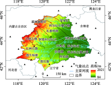
Fig. 1
Location of the Horqin Sandy Land"

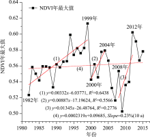
Fig. 2
Trend of vegetation coverage in Horqin Sandy Land during 1982-2015"

Fig. 3
Spatial distribution of mean NDVI in Horqin Sandy Land during 1982-2015 and its land cover types in 2010"
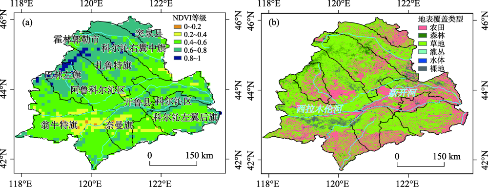

Fig. 4
Trend and significance of NDVI in the Horqin Sandy Land during 1982-2015"

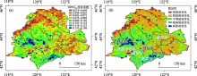
Fig. 5
Stability changes of NDVI in the Horqin Sandy Land during 1982-2015"

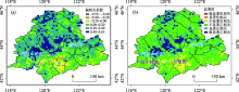
Fig. 6
Partial correlation coefficient and significance between NDVI and annual average precipitation in Horqin Sandy Land during 1982-2015"

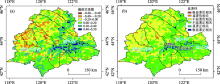
Fig. 7
Partial correlation coefficient and significance between NDVI and annual average temperature in Horqin Sandy Land during 1982-2015"
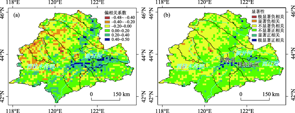
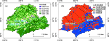
Fig. 8
Future trend of NDVI in the Horqin Sandy Land"

| [1] | Zhou D J, Zhao X, Hu H F, et al. Long-term vegetation changes in the four mega-sandy lands in Inner Mongolia, China[J]. Landscape Ecology, 2015,30(9):1613-1626. |
| [2] | 王静茹, 马龙, 刘廷玺. 1951—2012年科尔沁沙地气温、降水变化特征[J]. 干旱区研究, 2016,33(1):49-58. |
| [ Wang Jingru, Ma Long, Liu Tingxi. Variation of temperature and precipitation in Horqin Sandy Land from 1951 to 2012[J]. Arid Zone Research, 2016,33(1):49-58. ] | |
| [3] | Li J Y, Xu B, Yang X C, et al. Historical grassland desertification changes in the Horqin Sandy Land, Northern China (1985-2013)[J]. Scientific Reports, 2017,7(1):847-851. |
| [4] | 张勃, 王东, 王桂钢, 等. 西南地区近14 a植被覆盖变化及其与气候因子的关系[J]. 长江流域资源与环境, 2015,24(6):956-964. |
| [ Zhang Bo, Wang Dong, Wang Guigang, et al. Vegetation cover change over the Southwest China and its relationship to climatic factors[J]. Resources and Environment in the Yangtza Basin, 2015,24(6):956-964. ] | |
| [5] | Wang H, Liu G H, Li Z S, et al. Driving force and changing trends of vegetation phenology in the Loess Plateau of China from 2000 to 2010[J]. Journal of Mountain Science, 2016,13(5):844-856. |
| [6] | Liu Y L, Lei H M. Responses of natural vegetation dynamics to climate drivers in China from 1982 to 2011[J]. Remote Sensing, 2015,7(8):10243-10268. |
| [7] | Qu B, Zhu W B, Jia S F, et al. Spatio-temporal changes in vegetation activity and its driving factors during the growing season in China from 1982 to 2011[J]. Remote Sensing, 2015,7(10):13729-13752. |
| [8] | 王娟, 李宝林, 余万里. 近30年内蒙古自治区植被变化趋势及影响因素分析[J]. 干旱区资源与环境, 2012,26(2):132-138. |
| [ Wang Juan, Li Baolin, Yu Wanli. Analysis of vegetation trend and their causes during recent 30 years in Inner Mongolia Autonomous Region[J]. Journal of Arid Land Resources and Environment, 2012,26(2):132-138. ] | |
| [9] | 奚砚涛, 徐勇, 刘欣婷. 2000-2013年江苏省不同植被类型NDVI时空变化特征[J]. 水土保持研究, 2016,23(1):86-91, 2. |
| [ Xi Yantao, Xu Yong, Liu Xinting. Spatiotemporal change of different vegetation coverage in Jiangsu Province in the period from 2000 to 2013[J]. Research of Soil and Water Conservation, 2016,23(1):86-91, 2. ] | |
| [10] | Huang F, Wang P, Liu X N. Monitoring vegetation dynamic in Horqin Sandy Land from spot vegetation time series imagery[J]. Journal of Earth System Science, 2008,37, 915-920. |
| [11] | 胡砚霞, 黄进良, 杜耘, 等. 2000~2015年丹江口库区植被覆盖时空变化趋势及其成因分析[J]. 长江流域资源与环境, 2018,27(4):862-872. |
| [ Hu Yanxia, Huang Jinliang, Du Yun, et al. Spatio-temporal trends of vegetation coverage and their causes in the Danjiangkou Reservoir Region during 2000 to 2015[J]. Resources and Environment in the Yangtza Basin, 2018,27(4):862-872. ] | |
| [12] | 乌兰吐雅, 哈斯础鲁, 吉木色, 等. 内蒙古四大沙地植被NDVI变化及气候响应研究[J]. 安徽农业科学, 2013,41(25):10457-10459, 10466. |
| [ Wulan Tuya, Hasi Chulu, Jimus e, et al. Research of climate response and NDVI changes of vegetation of Four Sandy in Inner Mongolia[J]. Journal of Anhui Agricultural Sciences, 2013,41(25):10457-10459, 10466. ] | |
| [13] | 段翰晨, 王涛, 薛娴, 等. 基于RS与GIS的科尔沁沙地沙漠化时空演变[J]. 中国沙漠, 2013,33(2):470-477. |
| [ Duan Hanchen, Wang Tao, Xue Xian, et al. Spatial-temporal evolution of aeolian desertification in the Horqin Sandy Land based on RS and GIS[J]. Journal of Desert Research, 2013,33(2):470-477. ] | |
| [14] | 马龙, 王静茹, 刘廷玺, 等. 2000—2012年科尔沁沙地植被与气候因子间的响应关系[J]. 农业机械学报, 2016,47(4):162-172. |
| [ Ma Long, Wang Jingru, Liu Tingxi, et al. Response relationship between vegetation and climate factors in Horqin Sandy Land from 2000 to 2012[J]. Transactions of the Chinese Society of Agricultural Machinery, 2016,47(4):162-172. ] | |
| [15] | 王思如, 雷慧闽, 段利民, 等. 气候变化对科尔沁沙地蒸散发和植被的影响[J]. 水利学报, 2017,48(5):535-544, 550. |
| [ Wang Siru, Lei Huimin, Duan Limin, et al. Simulated impacts of climate change on evapotranspiration and vegetation in Horqin Sandy Land[J]. Journal of Hydraulic Engineering, 2017,48(5):535-544, 550. ] | |
| [16] | 魏丰良, 刘廷玺, 张圣微, 等. 科尔沁沙地植被覆盖变化及其与气候因子的关系研究[J]. 水土保持研究, 2012,19(3):254-258. |
| [ Wei Fengliang, Liu Tingxi, Zhang Shengwei, et al. Research for vegetation cover change of Horqin Sandy Land and its relationship with the climate factors[J]. Research of Soil and Water Conservation, 2012,19(3):254-258. ] | |
| [17] | 李生勇, 王晓卿, 李彪. 基于MODIS数据的科尔沁区植被覆盖时空变化分析[J]. 长江科学院院报, 2016,33(2):118-122, 127. |
| [ Li Shengyong, Wang Xiaoqing, Li Biao. Spatio-temporal analysis of vegetation cover change based on MODIS data in Horqin District[J]. Journal of Yangtze River Scientific Research Institute, 2016,33(2):118-122, 127. ] | |
| [18] | 王永芳, 张继权, 马齐云, 等. 21世纪初科尔沁沙地沙漠化对区域气候变化的响应[J]. 农业工程学报, 2016,32(增刊2):177-185. |
| [ Wang Yongfang, Zhang Jiquan, Ma Qiyun, et al. Response of aeolian desertification to regional climate change in Horqin sandy land at beginning of 21st century[J]. Transactions of the Chinese Society of Agricultural Engineering, 2016,32(Suppl.2):177-185. ] | |
| [19] | Ana M Maria U, Pérez-Goya Unai. Stochastic spatio-temporal models for analysing NDVI distribution of GIMMS NDVI3g images[J]. Remote Sensing, 2017,9(1):76. |
| [20] | Scott J Goetz, Gregory J Fiske, Andrew G Bunn. Using satellite time-series data sets to analyze fire disturbance and forest recovery across Canada[J]. Remote Sensing of Environment, 2006,101(3):352-365. |
| [21] | Zhang Y L, Gao J G, Liu L S, et al. NDVI-based vegetation changes and their responses to climate change from 1982 to 2011: A case study in the Koshi River Basin in the middle Himalayas[J]. Global and Planetary Change, 2013,108:139-148. |
| [22] | 吕洋, 董国涛, 杨胜天, 等. 雅鲁藏布江流域NDVI时空变化及其与降水和高程的关系[J]. 资源科学, 2014,36(3):603-611. |
| [ Lyu Yang, Dong Guotao, Yang Shengtian, et al. Spatio-temporal variation in NDVI in the Yarlung Zangbo River Basin and its relationship with precipitation and elevation[J]. Resources Science, 2014,36(3):603-611. ] | |
| [23] |
Hou X Y, Li M J, Gao M, et al. Spatial-temporal dynamics of NDVI and Chl-a concentration from 1998 to 2009 in the East coastal zone of China: Integrating terrestrial and oceanic components[J]. Environmental Monitoring and Assessment, 2013,185(1):267-277.
pmid: 22367366 |
| [24] | 刘宪锋, 潘耀忠, 朱秀芳, 等. 2000-2014年秦巴山区植被覆盖时空变化特征及其归因[J]. 地理学报, 2015,70(5):705-716. |
| [ Liu Xianfeng, Pan Yaozhong, Zhu Xiufang, et al. Spatiotemporal variation of vegetation coverage in Qinling-Daba Mountains in relation to environmental factors[J]. Acta Geographica Sinica, 2015,70(5):705-716. ] | |
| [25] | 赵安周, 张安兵, 刘海新, 等. 退耕还林(草)工程实施前后黄土高原植被覆盖时空变化分析[J]. 自然资源学报, 2017,32(3):449-460. |
| [ Zhao Anzhou, Zhang Anbing, Liu Haixin, et al. Spatiotemporal variation of vegetation coverage before and after implementation of Grain for Green Project in the Loess Plateau[J]. Journal of Natural Resources, 2017,32(3):449-460. ] | |
| [26] | 穆少杰, 李建龙, 陈奕兆, 等. 2001-2010年内蒙古植被覆盖度时空变化特征[J]. 地理学报, 2012,67(9):1255-1268. |
| [ Mu Shaojie, Li Jianlong, Chen Yizhao, et al. Spatial differences of variations of vegetation coverage in Inner Mongolia during 2001-2010[J]. Acta Geographica Sinica, 2012,67(9):1255-1268. ] | |
| [27] | Liu X F, Zhang J S, Zhu X F, et al. Spatiotemporal changes in vegetation coverage and its driving factors in the Three-River Headwaters Region during 2000-2011[J]. Acta Geographica Sinica, 2014,24(2):288-302. |
| [28] | 刘宪锋, 朱秀芳, 潘耀忠, 等. 1982—2012年中国植被覆盖时空变化特征[J]. 生态学报, 2015,35(16):5331-5342. |
| [ Liu Xianfeng, Zhu Xiufang, Pan Yaozhong, et al. Spatiotemporal changes in vegetation coverage in China during 1982-2012[J]. Acta Ecologica Sinica, 2015,35(16):5331-5342. ] | |
| [29] | Wang Y F, Zhang J Q, Guo E L, et al. Estimation of variability characteristics of regional drought during 1964-2013 in Horqin Sandy Land, China[J]. Water, 2016,8(11):543. |
| [30] | 赵明伟, 王妮, 施慧慧, 等. 2001—2015年间我国陆地植被覆盖度时空变化及驱动力分析[J]. 干旱区地理, 2019,42(2):324-331. |
| [ Zhao Mingwei, Wang Ni, Shi Huihui, et al. Spatial-temporal variation and its driving forces of vegetation coverage in China from 2001 to 2015[J]. Arid Land Geography, 2019,42(2):324-331. ] | |
| [31] | 刘洋, 李诚志, 刘志辉, 等. 1982—2013年基于GIMMS-NDVI的新疆植被覆盖时空变化[J]. 生态学报, 2016,36(19):6198-6208. |
| [ Liu Yang, Li Chengzhi, Liu Zhihui, et al. Assessment of spatio-temporal variations in vegetation cover in Xinjiang from 1982 to 2013 based on GIMMS-NDVI[J]. Acta Ecologica Sinica, 2016,36(19):6198-6208. ] | |
| [32] | 陈登魁, 马超, 王夏冰, 等. 1982—2015年可可西里NDVI变化特征及其气候响应[J]. 干旱区研究, 2018,35(6):1410-1417. |
| [ Chen Dengkui, Ma Chao, Wang Xiabing, et al. Variation of NDVI and its response to climate change in Hoh Xil during the period of 1982-2015[J]. Arid Zone Research, 2018,35(6):1410-1417. ] |
| [1] | ZHANG Bin, ZHENG Xinjun, WANG Yugang, TANG Lisong, LI Yan, DU Lan, TIAN Shengchuan. Changes in the salt content of the plow layer soil during cultivation from 1990 to 2022 on the northern slope of the Tianshan Mountains [J]. Arid Zone Research, 2024, 41(9): 1435-1445. |
| [2] | YUAN Zheng, ZHANG Zhigao, YAN Jin, LIU Jiayi, HU Zhuyu, WANG Yun, CAI Maotang. Spatiotemporal characteristics of different grades of precipitation in Yellow River Basin from 1960 to 2020 [J]. Arid Zone Research, 2024, 41(8): 1259-1271. |
| [3] | HOU Jiaye, LI Jianhua, WANG Jiarong, MA Haitao, QIANG Zekai, FAN Xingang. The evolution of ecological quality in Yanchi County based on the SA-RSEI model [J]. Arid Zone Research, 2024, 41(6): 1045-1058. |
| [4] | JIJI Jiamen, CHENG Yiben, CHEN Linglong, WAN Pengxiang, ZHANG Yihui, YANG Wenbin, BAI Xuying, WANG Tao. Dynamic changes in soil moisture and its response to rainfall in Pinus sylvestris var. mongolica plantation in Horqin Sandy Land [J]. Arid Zone Research, 2023, 40(5): 756-766. |
| [5] | MA Haowen, WANG Yongfang, GUO Enliang. Remote sensing monitoring of aeolian desertification in Ongniud Banner based on GEE [J]. Arid Zone Research, 2023, 40(3): 504-516. |
| [6] | WU Rui, CAO Hongyu, GAO Guanglei, YU Minghan, DING Guodong, ZHANG Ying, ZHAO Peishan. Effects of irrigation and salinity treatments on the soil bacterial community and plant physiological characteristics of Cyperus esculentus farmland in Horqin Sandy Land [J]. Arid Zone Research, 2023, 40(12): 1938-1948. |
| [7] | XIA Yijie,WANG Shengjie,ZHANG Mingjun. Spatiotemporal variations of stable hydrogen and oxygen isotopes in Xinjiang tap water [J]. Arid Zone Research, 2022, 39(3): 810-819. |
| [8] | ZHAO Shuixia,WANG Wenjun,WU Yingjie,QUAN Qiang,WANG Sinan,CHEN Xiaojun,LIU Tiejun. Analysis of drought-driving climatic factors of Xilin Gol grassland in the past 59 years [J]. Arid Zone Research, 2021, 38(3): 785-793. |
| [9] | CAO Wenmei,LIU Tingxi,WANG Xixi,WANG Guanli,LI Dongfang,TONG Xing. Land use and land cover classifications of Horqin Sandy Land dune-meadow areas [J]. Arid Zone Research, 2021, 38(2): 526-535. |
| [10] | SHI Hongyan,RAN Lishan,YUE Rong,YU Ruihong,ZHAO Yanxia,LYU Xixi. Variations of CO2 exchange in the Kuye River basin and its influencing factors [J]. Arid Zone Research, 2021, 38(2): 369-379. |
| [11] | DENG Xiaojin,JING Changqing,GUO Wenzhang,CHEN Chen,FU Haoyu. Spatio-temporal variation characteristics of surface albedo and analysis of influential factors in the Junggar Basin [J]. Arid Zone Research, 2021, 38(2): 314-326. |
| [12] | SUN Shan-shan, LIU Xin-ping, WEI Shui-lian, ZHANG Tong-hui, HE Yu-hui, Chelmeg, LYU Peng, WANG Ming-ming. Response of Plant Seedling Growth to the Changes in Precipitation and Wind Velocity in Horqin Sandy Land [J]. Arid Zone Research, 2019, 36(4): 870-877. |
| [13] | BAO Yong-zhi, LIU Ting-xi, DUAN Li-min, WANG Guan-li, QI Xiu-jiao, HUANG Tian-Yu, LI Ming-Yang. Photosynthetic Traits of Caragana microphylla and Populus spp. and Their Responses to Climate in the Horqin Sandy Land [J]. Arid Zone Research, 2019, 36(2): 420-429. |
| [14] | CHEN Deng-kui, MA Chao, WANG Xia-bing, LIU Chang. Variation of NDVI and its response to climate change in Hoh Xil during the period of 1982-2015 [J]. , 2018, 35(6): 1410-1417. |
| [15] | MOU Le, LU Yi-xiao, YANG Hui-min, FENG Qi-sheng. Spatiotemporal Variation of Vegetation Cover in the Pastoral Area in Northwestern China during the Period of 1981-2015 [J]. , 2018, 35(3): 615-623. |
|
||