干旱区研究 ›› 2021, Vol. 38 ›› Issue (4): 1152-1161.doi: 10.13866/j.azr.2021.04.27 cstr: 32277.14.AZR.20210427
苏迎庆1( ),刘庚1,赵景波2,牛俊杰1(),张恩月1,郭利刚3,林菲1
收稿日期:2021-01-05
修回日期:2021-03-14
出版日期:2021-07-15
发布日期:2021-08-03
作者简介:苏迎庆(1994-),男,硕士研究生,主要从事资源环境评价与开发、生态承载力与生态安全研究. E-mail: 基金资助:
SU Yingqing1(),LIU Geng1,ZHAO Jingbo2,NIU Junjie1(),ZHANG Enyue1,GUO Ligang3,LIN Fei1
Received:2021-01-05
Revised:2021-03-14
Published:2021-07-15
Online:2021-08-03
摘要:
选取汾河流域为研究区,基于2015年、2018年土地利用类型数据,并采用EES模型筛选了对应基准年的20项驱动因子数据,利用FLUS模型,在验证模型精度有效性的基础上,模拟预测了2024年、2030年生产空间优先、生活空间优先、生态空间优先以及三生空间协调4种情景下汾河流域生态空间的时空演化特征及成因。结果表明:(1) 2018—2030年汾河流域生态空间呈现两类演变趋势,在生态空间优先、三生空间协调情景下呈现线性增长,分别增长5.92%、5.13%;生产空间优先、生活空间优先情景下呈现线性下降,分别下降9.40%、2.20%;生产、生活、生态空间用地结构比例维持4:1:5。(2) 时空格局上,生态空间位于流域边缘山区,生产、生活空间位于核心盆地,生态、生产、生活空间整体呈现依次嵌套的格局特征;生态空间核心区变化幅度较小,边缘区变化显著。(3) 2024年、2030年三生空间协调情景、生态空间优先情景下生态空间的演变趋势近似,受流域自然-社会发展趋势及国家政策影响,未来可利用后备土地资源有限,流域生态空间变化较小但也存在胁迫隐患。基于此,本文建议严格遵循“三线”(永久基本农田保护红线、生态保护红线、城镇开发边界线)基本原则,合理规划三生空间后备土地资源,对生态空间边缘区(生态敏感区)积极治理保育,核心区限制开发,促进流域科学发展。
苏迎庆,刘庚,赵景波,牛俊杰,张恩月,郭利刚,林菲. 基于FLUS模型的汾河流域生态空间多情景模拟预测[J]. 干旱区研究, 2021, 38(4): 1152-1161.
SU Yingqing,LIU Geng,ZHAO Jingbo,NIU Junjie,ZHANG Enyue,GUO Ligang,LIN Fei. Multi-scenario simulation prediction of ecological space in the Fenhe River Basin using the FLUS model[J]. Arid Zone Research, 2021, 38(4): 1152-1161.
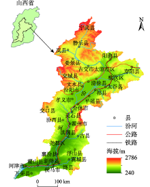
图1
汾河流域区位示意图"

表1
数据类型及来源"
| 数据类型 | 指标 | 数据来源 | |
|---|---|---|---|
| 基础数据 | 行政边界 | 山西省行政边界 | 2015年中国科学院资源环境科学数据中心(http://www.resdc.cn) |
| 土地利用 | 山西省土地利用数据 | 2015年、2018年中国科学院资源环境科学数据中心 (http://www.resdc.cn)(Landsat TM/ETM 30 m) | |
| EES驱动因子 | 经济因子 | 经济密度/(104元∙km-2) | 2015年、2018年《山西省统计年鉴》 |
| GDP增长率/% | |||
| 环保投资占GDP比例/% | |||
| 环境因子 | 高程/m | 中国科学院资源环境科学数据中心(http://www.resdc.cn) 2000年山西省DEM30m(SRTM 30 m) | |
| 坡度/(°) | |||
| 距河流/m | |||
| 人均水资源量/(人∙m-3) | 2015年、2018年《山西省水资源公报》 | ||
| 土壤养分有效性* | Har monized World Soil Database v 1.2(http://webarchive.iiasa.ac.at/Research)2008年 | ||
| 土壤根系氧利用率* | |||
| 土壤过盐量* | |||
| 土壤毒性* | |||
| 土壤可利用度* | |||
| 年均降水/mm | WorldClim version 2.0(http://www.worldclim.org/)2000年 | ||
| 年均气温/℃ | |||
| 水土协调度/% | 2015年、2018年《山西省统计年鉴》《山西省水资源公报》 | ||
| 社会因子 | 人口自然增长率/‰ | 2015年、2018年《山西省统计年鉴》 | |
| 人口密度/(人∙km-2) | |||
| 城市化率/% | |||
| 距主要交通干线/m | 国家基础地理信息中心(www.ngcc.cn/ngcc/) 2015年1:1000000中国基础地理信息数据 | ||
| 距主要居民点/m | |||
表2
邻域因子参数"
| 土地利用类型 | 建设用地 | 未利用土地 | 水域 | 草地 | 耕地 | 林地 |
|---|---|---|---|---|---|---|
| 领域因子参数/wk | 1 | 0.5 | 0.4 | 0.3 | 0.2 | 0.01 |
表3
不同情景用地类型转换成本"
| 情景类型 | 转化成本及原则 |
|---|---|
| 生产空间优先 | 除建设用地,其他用地类型均可转换为耕地 |
| 生活空间优先 | 根据城市发展需求,按低等级用地到高等级单向转换原则,土地转换等级排序为:建设用地、耕地、林地、草地、水域及未利用土地 |
| 生态空间优先 | 同生活空间优先情景转换原则,各类用地的生态效益等级排序:林地、水域、草地、其他 |
| 三生空间协调 | 综合以上3种单一情景的发展需求,土地转换等级排序为:建设、林地、耕地、水域、草地及未利用土地 |

图2
2018年汾河流域现状与模拟土地利用类型"

表4
2018年、2024年、2030年汾河流域多情景模拟三生空间用地情况"
| | 情景 | 生产空间 | 生活空间 | 生态空间 | |||||||
|---|---|---|---|---|---|---|---|---|---|---|---|
| 耕地面积 /km2 | 占比/% | 建设用地面积/km2 | 占比/% | 林地面积 /km2 | 草地面积 /km2 | 水域面积 /km2 | 未利用地面积/km2 | 小计/km2 | 占比/% | ||
| 2018 | 三生空间现状 | 15361.83 | 40.55 | 3132.99 | 8.27 | 10039.18 | 9042.80 | 302.18 | 4.81 | 19388.97 | 51.18 |
| 2024 | 生产空间优先 | 16126.38 | 42.58 | 3164.64 | 8.36 | 10155.47 | 8075.53 | 347.86 | 1.65 | 18580.50 | 49.06 |
| 生活空间优先 | 14431.00 | 38.10 | 4225.55 | 11.16 | 10031.08 | 8839.96 | 342.16 | 1.27 | 19214.47 | 50.74 | |
| 生态空间优先 | 14371.78 | 37.95 | 3142.24 | 8.30 | 10178.88 | 9828.74 | 348.24 | 2.02 | 20357.88 | 53.75 | |
| 三生空间协调 | 14372.41 | 37.95 | 3233.22 | 8.54 | 9913.02 | 10004.89 | 346.21 | 1.90 | 20266.01 | 53.51 | |
| 2030 | 生产空间优先 | 16272.16 | 42.96 | 3879.08 | 10.24 | 10243.41 | 7125.21 | 351.15 | 2.76 | 17722.53 | 46.80 |
| 生活空间优先 | 13623.93 | 35.97 | 5276.97 | 13.93 | 10113.84 | 8514.24 | 342.16 | 1.27 | 18971.51 | 50.10 | |
| 生态空间优先 | 13445.25 | 35.50 | 3898.19 | 10.29 | 10317.82 | 9857.47 | 352.16 | 1.14 | 20528.59 | 54.21 | |
| 三生空间协调 | 13448.42 | 35.51 | 4045.86 | 10.68 | 9875.81 | 10152.18 | 348.74 | 0.76 | 20377.49 | 53.81 | |
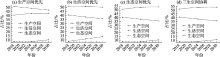
图3
2018—2030年4种情景三生空间演变趋势"

图4
2018年汾河流域土地利用类型及三生空间用地"

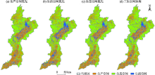
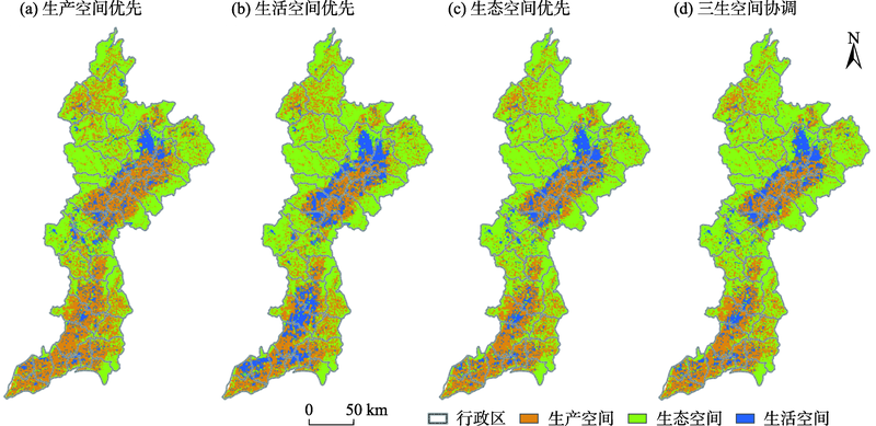
图5
2024年4种情景下汾河流域三生空间模拟结果"

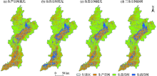
图6
2030年4种情景下汾河流域三生空间模拟结果"
| [1] | 曹小曙. 基于人地耦合系统的国土空间重塑[J]. 自然资源学报, 2019, 34(10):2051-2059. |
| [ Cao Xiaoshu. Geogovernance of national land use based on coupled human and natural systems[J]. Journal of Natural Resources, 2019, 34(10):2051-2059. ] | |
| [2] | 周劲. 三线·三生·三控: 城乡布局结构的宏观管控机制[J]. 规划师, 2019, 35(5):5-12. |
| [ Zhou Jin. Macro control mechanism of urban-rural layout with three lines, three spaces, and three controls[J]. Planners, 2019, 35(5):5-12. ] | |
| [3] | 龚亚男, 韩书成, 时晓标, 等. 广东省“三生空间”用地转型的时空演变及其生态环境效应[J]. 水土保持研究, 2020, 27(3):203-209. |
| [ Gong Yanan, Han Shucheng, Shi Xiaobiao, et al. Temporal and spatial evolution and associated eco-environment effects of the land use transformation of ecological-production-living spaces in Guangdong Province[J]. Research of Soil and Water Conservation, 2020, 27(3):203-209. ] | |
| [4] | 王旭, 马伯文, 李丹, 等. 基于FLUS模型的湖北省生态空间多情景模拟预测[J]. 自然资源学报, 2020, 35(1):230-242. |
| [ Wang Xu, Ma Bowen, Li Dan, et al. Multi-scenario simulation and prediction of ecological space in Hubei province based on FLUS model[J]. Journal of Natural Resources, 2020, 35(1):230-242. ] | |
| [5] | 戴文远, 江方奇, 黄万里, 等. 基于“三生空间”的土地利用功能转型及生态服务价值研究——以福州新区为例[J]. 自然资源学报, 2018, 33(12):2098-2109. |
| [ Dai Wenyuan, Jiang Fangqi, Huang Wanli, et al. Study on transition of land use function and ecosystem service value based on the conception of production, living and ecological space: A case study of the Fuzhou new area[J]. Journal of Natural Resources, 2018, 33(12):2098-2109. ] | |
| [6] | 江曼琦, 刘勇. “三生”空间内涵与空间范围的辨析[J]. 城市发展研究, 2020, 27(4):43-48, 61. |
| [ Jiang Manqi, Liu Yong. Discussion on the concept definition and spatial boundary classification of “Production-Living-Ecological” space[J]. Urban Development Studies, 2020, 27(4):43-48, 61. ] | |
| [7] | 许尔琪, 张红旗. 中国核心生态空间的现状、变化及其保护研究[J]. 资源科学, 2015, 37(7):1322-1331. |
| [ Xu Erqi, Zhang Hongqi. Land use structure and change of important ecological space in China and protection research[J]. Resources Science, 2015, 37(7):1322-1331. ] | |
| [8] |
于正松, 程叶青, 李小建, 等. 工业镇“生产-生活-生态”空间演化过程、动因与重构——以河南省曲沟镇为例[J]. 地理科学, 2020, 40(4):646-656.
doi: 10.13249/j.cnki.sgs.2020.04.017 |
|
[ Yu Zhengsong, Cheng Yeqing, Li Xiaojian, et al. Spatial evolution process, motivation and reconstruction of “Production-Living-Ecology” in industrial town: A case study on Qugou Town in Henan Province[J]. Scientia Geographica Sinica, 2020, 40(4):646-656. ]
doi: 10.13249/j.cnki.sgs.2020.04.017 |
|
| [9] | 张驭航, 李玲, 王秀丽, 等. 基于模糊伽马模型的河南省生态空间辨识与格局优化[J]. 水土保持研究, 2020, 27(6):211-217, 225. |
| [ Zhang Yuhang, Li Ling, Wang Xiuli, et al. Ecological spatial identification and pattern optimization in Henan Province based on fuzzy gamma model[J]. Research of Soil and Water Conservation, 2020, 27(6):211-217, 225. ] | |
| [10] | 丁乙宸, 刘科伟, 程永辉, 等. 县级国土空间规划中“三区三线”划定研究——以延川县为例[J]. 城市发展研究, 2020, 27(5):1-9. |
| [ Ding Yichen, Liu Kewei, Cheng Yonghui, et al. Study on the delimitation of “Three Zones and Three Lines” of county territorial spatial planning: A case study of Yanchuan County[J]. Urban Development Studies, 2020, 27(5):1-9. ] | |
| [11] | 刘彦文, 刘成武, 何宗宜, 等. 基于地理加权回归模型的武汉城市圈生态用地时空演变及影响因素[J]. 应用生态学报, 2020, 31(3):987-998. |
| [ Liu Yanwen, Liu Chengwu, He Zongyi, et al. Spatial-temporal evolution of ecological land and influence factors in Wuhan urban agglomeration based on geographically weighted regression model[J]. Chinese Journal of Applied Ecology, 2020, 31(3):987-998. ] | |
| [12] | 陈德超, 施祝凯, 王祖静, 等. 苏州环太湖地区生态网络构建与空间冲突识别[J]. 生态与农村环境学报, 2020, 36(6):778-787. |
| [ Chen Dechao, Shi Zhukai, Wang Zujing, et al. Ecological network construction and spatial conflict identification around Taihu Lake Area in Suzhou City[J]. Journal of Ecology and Rural Environment, 2020, 36(6):778-787. ] | |
| [13] | 王筱春, 夏雪, 雷轩. 基于生态保护红线的滇池流域生态空间管控[J]. 经济地理, 2020, 40(5):191-197. |
| [ Wang Xiaochun, Xia Xue, Lei Xuan. Ecological space control of Dianchi Lake Basin based on ecological protection red line[J]. Economic Geography, 2020, 40(5):191-197. ] | |
| [14] | 周宇洋, 周国富, 黄启芬, 等. 基于洛伦兹曲线和土地利用转型的喀斯特山区“三生”空间分布研究[J]. 水土保持通报, 2020, 40(3):297-304, 325. |
| [ Zhou Yuyang, Zhou Guofu, Huang Qifen, et al. A study on distribution of production, Living and Ecological Space in Karst Areas based on lorenz curves and land use transitions[J]. Bulletin of Soil and Water Conservation, 2020, 40(3):297-304, 325. ] | |
| [15] | 杜腾飞, 齐伟, 朱西存, 等. 基于生态安全格局的山地丘陵区自然资源空间精准识别与管制方法[J]. 自然资源学报, 2020, 35(5):1190-1200. |
| [ Du Tengfei, Qi Wei, Zhu Xicun, et al. Precise identification and control method of natural resources space based on ecological security pattern in mountainous hilly area[J]. Journal of Natural Resources, 2020, 35(5):1190-1200. ] | |
| [16] | 潘方杰, 王宏志, 宋明洁, 等. 基于GIS的国家重点生态功能区生态空间识别研究——以湖北长阳县为例[J]. 华中师范大学学报(自然科学版), 2020, 54(4):658-669. |
| [ Pan Fangjie, Wang Hongzhi, Song Mingjie, et al. Research on spatial identification of ecological space in national key ecological function regions based on GIS: A case study of Changyang Country in Hubei Province, China[J]. Journal of Central China Normal University(Natural Sciences Edition), 2020, 54(4):658-669. ] | |
| [17] | 陈爽, 刘云霞, 彭立华. 城市生态空间演变规律及调控机制——以南京市为例[J]. 生态学报, 2008, 28(5):2270-2278. |
| [ Chen Shuang, Liu Yunxia, Peng Lihua. Dynamics of urban ecological space evolution and policy responses: A case study of Nanjing City[J]. Acta Ecologica Sinica, 2008, 28(5):2270-2278. ] | |
| [18] | 李京京, 吕哲敏, 石小平, 等. 基于地形梯度的汾河流域土地利用时空变化分析[J]. 农业工程学报, 2016, 32(7):230-236. |
| [ Li Jingjing, Lyu Zhemin, Shi Xiaoping, et al. Spatiotemporal variations analysis for land use in Fen River Basin based on terrain gradient[J]. Transactions of the Chinese Society of Agricultural Engineering, 2016, 32(7):230-236. ] | |
| [19] | 郭利刚, 冯珍珍, 刘庚, 等. 基于物元模型的汾河流域土地生态安全评价[J]. 生态学杂志, 2020, 39(6):2061-2069. |
| [ Guo Ligang, Feng Zhenzhen, Liu Geng, et al. Evaluation of land eco-security in Fenhe River Basin based on matter-element model[J]. Chinese Journal of Ecology, 2020, 39(6):2061-2069. ] | |
| [20] | Liu X P, Liang X, Li X, et al. A future land use simulation model (FLUS) for simulating multiple land use scenarios by coupling human and natural effects[J]. Landscape & Urban Planning, 2017, 168:94-116. |
| [21] | Lin W B, Sun Y M, Steffen N, et al. Scenario-based flood risk assessment for urbanizing deltas using future land-use simulation (FLUS): Guangzhou Metropolitan Area as a case study[J]. Science of the Total Environment, 2020, 739: DOI: 10.1016/j.scitotenv.2020.139899. |
| [22] |
杨露, 颉耀文, 宗乐丽, 等. 基于多目标遗传算法和FLUS模型的西北农牧交错带土地利用优化配置[J]. 地球信息科学学报, 2020, 22(3):568-579.
doi: 10.12082/dqxxkx.2020.190531 |
|
[ Yang Lu, Xie Yaowen, Zong Leli, et al. Land use optimization configuration based on multi-objective genetic algorithm and FLUS model of agro-pastoral ecotone in Northwest China[J]. Journal of Geo-information Science, 2020, 22(3):568-579. ]
doi: 10.12082/dqxxkx.2020.190531 |
|
| [23] | 陈兵飞, 廖铁军, 张莉坤. 生态红线约束下万州区土地利用情景模拟及生态价值评估[J]. 水土保持研究, 2020, 27(5):349-357,364. |
| [ Chen Bingfei, Liao Tiejun, Zhang Likun. Simultion of land use situan and ecological value assessmentin Wanzhou district under the constraints of ecological red line[J]. Research of Soil and Water Conservation, 2020, 27(5):349-357, 364. ] | |
| [24] |
赵林峰, 刘小平, 刘鹏华, 等. 基于地理分区与FLUS模型的城市扩张模拟与预警[J]. 地球信息科学学报, 2020, 22(3):517-530.
doi: 10.12082/dqxxkx.2020.190477 |
|
[ Zhao Linfeng, Liu Xiaoping, Liu Penghua, et al. Urban expansion simulation and early warning based on geospatial partition and FLUS model[J]. Journal of Geo-information Science, 2020, 22(3):517-530. ]
doi: 10.12082/dqxxkx.2020.190477 |
|
| [25] | 王培俊, 孙煌, 华宝龙, 等. 福州市滨海地区生态系统服务价值评估与动态模拟[J]. 农业机械学报, 2020, 51(3):249-257. |
| [ Wang Peijun, Sun Huang, Hua Baolong, et al. Evaluation and dynamic simulation of ecosystem service value in coastal area of Fuzhou City[J]. Transactions of the Chinese Society for Agricultural Machinery, 2020, 51(3):249-257. ] | |
| [26] | 王毅, 魏江超, 孙启元, 等. 基于ARIMA-ANN模型的生态安全评价及预测——以河西走廊城市群为例[J]. 生态学杂志, 2020, 39(1):326-336. |
| [ Wang Yi, Wei Jiangchao, Sun Qiyuan, et al. Ecological security evaluation and prediction based on ARIMA-ANN model: A case study of Hexi Corridor urban agglomeration[J]. Chinese Journal of Ecology, 2020, 39(1):326-336. ] | |
| [27] |
张经度, 梅志雄, 吕佳慧, 等. 纳入空间自相关的FLUS模型在土地利用变化多情景模拟中的应用[J]. 地球信息科学学报, 2020, 22(3):531-542.
doi: 10.12082/dqxxkx.2020.190359 |
|
[ Zhang Jingdu, Mei Zhixiong, Lyu Jiahui, et al. Simulating multiple land use scenarios based on the FLUS model considering spatial autocorrelation[J]. Journal of Geo-information Science, 2020, 22(3):531-542. ]
doi: 10.12082/dqxxkx.2020.190359 |
|
| [28] | 秦埼瑞, 李雪梅, 陈庆伟, 等. 基于FLUS模型的天山山区未来土地利用变化预估[J]. 干旱区研究, 2019, 36(5):1270-1279. |
| [ Qin Qirui, Li Xuemei, Chen Qingwei, et al. Estimation of future land use change in the Tianshan mountainous based on FLUS model[J]. Arid Zone Research, 2019, 36(5):1270-1279. ] | |
| [29] | 王明常, 郭鑫, 王凤艳, 等. 基于FLUS的长春市土地利用动态变化与预测分析[J]. 吉林大学学报(地球科学版), 2019, 49(6):1795-1804. |
| [ Wang Mingchang, Guo Xin, Wang Fengyan, et al. Dynamic change and predictive analysis of land use types in Changchun City based on FLUS model[J]. Journal of Jilin Unviersity:Earth Science Edition, 2019, 49(6):1795-1804. ] | |
| [30] |
张世伟, 魏璐瑶, 金星星, 等. 基于FLUS-UGB的县域土地利用模拟及城镇开发边界划定研究[J]. 地球信息科学学报, 2020, 22(9):1848-1859.
doi: 10.12082/dqxxkx.2020.190452 |
|
[ Zhang Shiwei, Wei Luyao, Jin Xingxing, et al. Research on county land use simulation and urban development boundary delineation based on FLUS-UGB[J]. Journal of Geo-information Science, 2020, 22(9):1848-1859. ]
doi: 10.12082/dqxxkx.2020.190452 |
|
| [31] | 欧阳晓, 贺清云, 朱翔. 多情景下模拟城市群土地利用变化对生态系统服务价值的影响——以长株潭城市群为例[J]. 经济地理, 2020, 40(1):93-102. |
| [ Ouyang Xiao, He Qingyun, Zhu Xiang. Simulation of impacts of urban agglomeration land use change on ecosystem services value under multi-scenarios: A case study in Changsha-Zhuzhou-Xiangtan urban agglomeration[J]. Economic Geography, 2020, 40(1):93-102. ] | |
| [32] | 刘顺鑫, 黄云. “三生空间”视角下万州区景观生态安全评价及其耦合特征分析[J]. 水土保持研究, 2020, 27(6):308-316. |
| [ Liu Shunxin, Huang Yun. Evaluation and coupling coordination analysis of landspace ecological security of Wanzhou district from the perspective of Production-Life-Ecological Space[J]. Research of Soil and Water Conservation, 2020, 27(6):308-316. ] |
| [1] | 吴朝巧, 林菲, 牛俊杰, 耿甜伟. 山西中部城市群生态系统服务对土地利用格局变化的响应[J]. 干旱区研究, 2024, 41(7): 1153-1166. |
| [2] | 徐铭璟, 冯强, 吕萌. 生态系统服务权衡及其影响因素——以黄河流域山西段为例[J]. 干旱区研究, 2024, 41(3): 467-479. |
| [3] | 周义, 索文姣. 基于CWSI的汾河流域干旱时空变化特征[J]. 干旱区研究, 2024, 41(2): 191-199. |
| [4] | 许丽婷,刘海红,黄丽洁,王钰帆. 2000—2020年汾河流域生态环境与水源涵养时空变化[J]. 干旱区研究, 2023, 40(2): 313-325. |
| [5] | 张恩月, 郑君焱, 苏迎庆, 张蕾, 张鹏飞, 刘庚. 基于情景模拟的流域低碳土地利用格局优化研究——以汾河流域为例[J]. 干旱区研究, 2023, 40(2): 203-212. |
| [6] | 张建华, 张琨, 刘勇, 张红, 张凯权, 周晓阳, 徐龙超. 山西省露天煤矿复垦区典型人工林凋落物持水性能研究[J]. 干旱区研究, 2023, 40(12): 2043-2052. |
| [7] | 姬倩倩, 潘换换, 吴树荣, 武志涛, 杜自强. 山西黄河流域“三生”空间重构和降水变化对产水服务的影响[J]. 干旱区研究, 2023, 40(1): 132-142. |
| [8] | 刘海龙,唐飞,丁娅楠,张羽,郭晓佳,谭景柏,程岳. 山西省县域高质量发展与生态系统服务耦合的时空演变特征[J]. 干旱区研究, 2022, 39(4): 1234-1245. |
| [9] | 苏迎庆,张恩月,刘源,刘庚,林菲. 汾河流域土地利用变化及生态环境效应[J]. 干旱区研究, 2022, 39(3): 968-977. |
| [10] | 陶静,赵文吉,王旭,薛进. 念青唐古拉山西段冰湖时空变化分析[J]. 干旱区研究, 2021, 38(3): 618-628. |
| [11] | 秦埼瑞, 李雪梅, 陈庆伟, 田亚林. 基于FLUS模型的天山山区未来土地利用变化预估 [J]. 干旱区研究, 2019, 36(5): 1270-1279. |
| [12] | 王咏梅, 张红雨, 郭雪, 刘慧丽, 李润春. 山西省近48 a高温和强降水极端事件变化特征[J]. 干旱区研究, 2012, 29(2): 289-295. |
| [13] | 冯佳,谢树莲. 山西省鱼鳞藻属植物新纪录[J]. 干旱区研究, 2012, 29(1): 182-185. |
| [14] | 赵桂香, 杜莉, 卫丽萍, 贺耀武, 李莹, 朱煜. 一次持续性区域雾霾天气的综合分析[J]. 干旱区研究, 2011, 28(5): 871-878. |
| [15] | 王姣妍, 谢蕾. 中国天山西部匹里青河的洪水及其成因[J]. 干旱区研究, 2011, 28(5): 756-760. |
|
||