干旱区研究 ›› 2022, Vol. 39 ›› Issue (3): 968-977.doi: 10.13866/j.azr.2022.03.30
苏迎庆1( ),张恩月2,刘源3,刘庚1(),林菲1
收稿日期:2021-08-03
修回日期:2021-10-28
出版日期:2022-05-15
发布日期:2022-05-30
通讯作者:
刘庚
作者简介:苏迎庆(1994-),男,硕士研究生,主要从事资源环境评价与开发、生态承载力与生态安全研究. E-mail: 基金资助:
SU Yingqing1(),ZHANG Enyue2,LIU Yuan3,LIU Geng1(),LIN Fei1
Received:2021-08-03
Revised:2021-10-28
Online:2022-05-15
Published:2022-05-30
Contact:
Geng LIU
摘要:
选取汾河流域为研究区,采用土地利用动态度、地学信息图谱、生态价值指数和植被覆盖度综合分析研究区2000年、2005年、2010年、2015年及2018年土地利用变化及生态环境影响效应问题。结果表明:(1) 2000—2018年,流域建设用地、林地呈现增长趋势,增长面积分别为1350.90 km2、85.50 km2,增长率分别为92.83%、0.96%;耕地、草地出现小幅下降趋势,缩减面积分别为729 km2、674.10 km2,缩减率分别为-5.02%、-7.63%;水域及未利用土地维持多年平均水平,平均面积为297 km2、7.92 km2。空间格局呈现建设用地、耕地集中于流域核心区,草地、林地集中于边缘区的分异特征。(2) 各时序综合土地利用动态度、土地转移图谱、土地利用涨落势变化近似,显著变化区主要位于流域盆地及其与山地过渡区,多年综合土地利用动态度为4.34%,单一土地利用动态度及土地利用涨势幅度最高的是建设用地及林地。(3) 基于不同的主导土地利用类型影响,生态价值指数时序演变呈现“下降-增长-下降”的波浪状曲线特征;植被覆盖度经历“增长-下降-增长”的演变特征;空间格局上与土地利用变化区域呈现空间斑块重叠。地形结构、用地标准、社会经济及环保政策等因子驱动下,未来流域土地利用变化或将加大,对生态环境的胁迫增强。
苏迎庆,张恩月,刘源,刘庚,林菲. 汾河流域土地利用变化及生态环境效应[J]. 干旱区研究, 2022, 39(3): 968-977.
SU Yingqing,ZHANG Enyue,LIU Yuan,LIU Geng,LIN Fei. Land-use change and ecological environment effects on Fenhe River Basin[J]. Arid Zone Research, 2022, 39(3): 968-977.
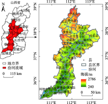
图1
汾河流域位置示意图"

表1
不同土地类型的相对生态价值"
| 土地利用类型 | 耕地 | 林地 | 草地 | 水域 | 建设用地 | 未利用地 |
|---|---|---|---|---|---|---|
| 对应的生态系统 | 农田 | 森林 | 草地 | 水体和湿地 | 荒漠 | 荒漠 |
| 相对生态价值/[元·(hm2·a)-1] | 0.316 | 1.0 | 0.331 | 0.865 | 0.039 | 0.019 |
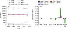
图2
汾河流域各时序土地利用面积变化及动态度"

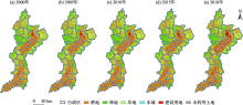
图3
2000年、2005年、2010年、2015年、2018年汾河流域土地利用格局"

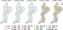
图4
汾河流域各时序土地利用转型图谱"
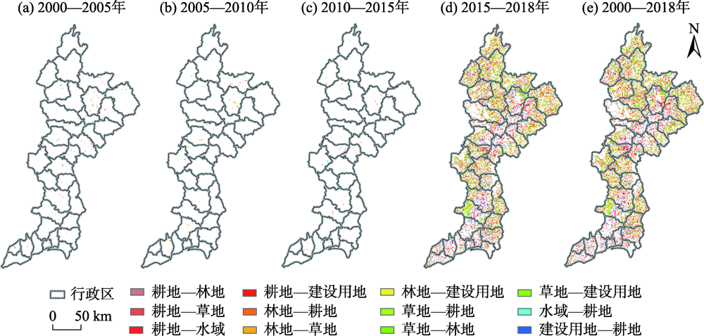
图5
汾河流域各时序单元土地利用涨落势图谱"


图6
2000—2018年汾河流域生态价值指数变化趋势"

图7
2000年、2005年、2010年、2015年及2018年汾河流域生态价值指数时空格局"

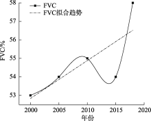
图8
2000—2018年汾河流域植被覆盖度变化趋势"

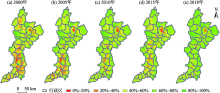
图9
2000年、2005年、2010年、2015年及2018年汾河流域植被覆盖度时空格局"

| [1] |
Raju R, Zhang Y L, Basanta P, et al. Satellite image based monitoring of urban land use change and assessing the driving factors in Pokhara and Bharatpur metropolitan cities, Gandaki Basin, Nepal[J]. Journal of Resources and Ecology, 2020, 11(1): 87-99.
doi: 10.5814/j.issn.1674-764x.2020.01.009 |
| [2] | 段红腾, 吴发启, 杨一凡, 等. 近10年巴音河流域土地利用变化及驱动力分析[J]. 水土保持研究, 2020, 27(2): 172-177. |
| [ Duan Hongteng, Wu Faqi, Yang Yifan, et al. Land use change and driving force analysis of Bayin River Basin in the past 10 years[J]. Research of Soil and Water Conservation, 2020, 27(2): 172-177. ] | |
| [3] |
Saddique N, Mahmood T, Bernhofer C. Quantifying the impacts of land use/land cover change on the water balance in the afforested River Basin, Pakistan[J]. Environmental Earth Sciences, 2020, 79(19), doi: 10.1007/s12665-020-09206-w.
doi: 10.1007/s12665-020-09206-w |
| [4] |
Gaur S, Mittal A, Bandyopadhyay A, et al. Spatio-temporal analysis of land use and land cover change: A systematic model inter-comparison driven by integrated modelling techniques[J]. International Journal of Remote Sensing, 2020, 41(23): 9229-9255.
doi: 10.1080/01431161.2020.1815890 |
| [5] | 张云红, 王道杰, 江晓波, 等. 岷江上游土地利用变化及其对生态环境的影响[J]. 西南大学学报(自然科学版), 2010, 32(3): 102-108. |
| [ Zhang Yunhong, Wang Daojie, Jiang Xiaobo, et al. Changes in land use in the upper reaches of the Minjiang River and their effects on the local eco-environment[J]. Journal of Southwest University (Natural Science Edition), 2010, 32(3): 102-108. ] | |
| [6] | 胡昕利, 易扬, 康宏樟, 等. 近25年长江中游地区土地利用时空变化格局与驱动因素[J]. 生态学报, 2019, 39(6): 1877-1886. |
| [ Hu Xinli, Yi Yang, Kang Hongzhang, et al. Temporal and spatial variations of land use and the driving factors in the middle reaches of the Yangtze River in the past 25 years[J]. Acta Ecologica Sinica, 2019, 39(6): 1877-1886. ] | |
| [7] |
付建新, 曹广超, 郭文炯. 1980-2018年祁连山南坡土地利用变化及其驱动力[J]. 应用生态学报, 2020, 31(8): 2699-2709.
doi: 10.13287/j.1001-9332.202008.017 pmid: 34494793 |
|
[ Fu Jianxin, Cao Guangchao, Guo Wenjiong. Land use change and its driving force on the southern slope of Qilian Mountains from 1980 to 2018[J]. Chinese Journal of Applied Ecology, 2020, 31(8): 2699-2709. ]
doi: 10.13287/j.1001-9332.202008.017 pmid: 34494793 |
|
| [8] | 刘玉斌, 王晓利, 侯西勇, 等. 四个时期和模拟情景下2025年黄河三角洲的土地利用格局和生态系统服务价值评估[J]. 湿地科学, 2020, 18(4): 424-436. |
| [ Liu Yubin, Wang Xiaoli, Hou Xiyong, et al. Land use pattern and evaluation of ecosystem service values of Yellow River Delta for 4 periods and in 2025 under simulation scenarios[J]. Wetland Science, 2020, 18(4): 424-436. ] | |
| [9] |
白娥, 薛冰. 土地利用与土地覆盖变化对生态系统的影响[J]. 植物生态学报, 2020, 44(5): 543-552.
doi: 10.17521/cjpe.2020.0071 |
|
[ Bai E, Xue Bing. A review of influences of land use and land cover change on ecosystems[J]. Chinese Journal of Plant Ecology, 2020, 44(5): 543-552. ]
doi: 10.17521/cjpe.2020.0071 |
|
| [10] | 李丹, 黎夏, 刘小平, 等. GPU-CA模型及大尺度土地利用变化模拟[J]. 科学通报, 2012, 57(11): 959-969. |
| [ Li Dan, Li Xia, Liu Xiaoping, et al. GPU-CA model and large-scale land use change simulation[J]. China Science Bulletin, 2012, 57(11): 959-969. ] | |
| [11] |
陈万旭, 李江风, 曾杰, 等. 中国土地利用变化生态环境效应的空间分异性与形成机理[J]. 地理研究, 2019, 38(9): 2173-2187.
doi: 10.11821/dlyj020180659 |
|
[ Chen Wanxu, Li Jiangfeng, Zeng Jie, et al. Spatial heterogeneity and formation mechanism of eco-environmental effect of land use change in China[J]. Geographical Research, 2019, 38(9): 2173-2187. ]
doi: 10.11821/dlyj020180659 |
|
| [12] |
李胜鹏, 柳建玲, 林津, 等. 基于1980-2018年土地利用变化的福建省生境质量时空演变[J]. 应用生态学报, 2020, 31(12): 4080-4090.
doi: 10.13287/j.1001-9332.202012.019 pmid: 33393245 |
|
[ Li Shengpeng, Liu Jianling, Lin Jin, et al. Spatial and temporal evolution of habitat quality in Fujian Province, China based on the land use change from 1980 to 2018[J]. Chinese Journal of Applied Ecology, 2020, 31(12): 4080-4090. ]
doi: 10.13287/j.1001-9332.202012.019 pmid: 33393245 |
|
| [13] | 覃事娅, 王忠诚. 基于不同职能城市耕地多功能演变及驱动力分析[J]. 中国水土保持科学, 2020, 18(4): 94-102. |
| [ Qin Shiya, Wang Zhongcheng. Multi-function evolutions of arable land and its driving forces based on different functional types of cities[J]. Science of Soil and Water Conservation, 2020, 18(4): 94-102. ] | |
| [14] | 侯蕾, 彭文启, 刘培斌, 等. 永定河上游流域土地利用变化及生态环境效应研究[J]. 中国水利水电科学研究院学报, 2017, 15(6): 430-438. |
| [ Hou Lei, Peng Wenqi, Liu Peibin, et al. Land use change and its ecological environmental effect in the upstream of Yongding River[J]. Journal of China Institute of Water Resources and Hydropower Research, 2017, 15(6): 430-438. ] | |
| [15] | 傅颖秀, 张金龙, 陈英, 等. 黑河中游典型绿洲土地利用/覆盖变化及生态环境效应--以甘州、临泽、高台绿洲为例[J]. 干旱区资源与环境, 2014, 28(10): 104-109. |
| [ Fu Yingxiu, Zhang Jinlong, Chen Ying, et al. LUCC and its environmental effects on the typical oases in the middle reaches of Heihe river basin: Case of Linze and Gaotai oases in Ganzhou[J]. Journal of Arid Land Resources and Environment, 2014, 28(10): 104-109. ] | |
| [16] | 宋永永, 薛东前, 代兰海, 等. 晋陕蒙典型化石能源开发区土地利用变化及其生态响应[J]. 干旱区研究, 2018, 35(5): 1199-1207. |
| [ Song Yongyong, Xue Dongqian, Dai Lanhai, et al. Land use change and its effects on ecological response in typical fossl energy development zones in Shanxi, Shaanxi and Inner Mongolia[J]. Arid Zone Research, 2018, 35(5): 1199-1207. ] | |
| [17] | 吴云, 曾源, 赵炎, 等. 基于MODIS数据的海河流域植被覆盖度估算及动态变化分析[J]. 资源科学, 2010, 32(7): 1417-1424. |
| [ Wu Yun, Zeng Yuan, Zhao Yan, et al. Monitoring and dynamic analysis of fractional vegetation cover in the Hai River Basin based on MODIS data[J]. Resources Science, 2010, 32(7): 1417-1424. ] | |
| [18] |
Zhang C B, Zhang Y, Wang Z Q, et al. Monitoring phenology in the temperate grasslands of China from 1982 to 2015 and its relation to net primary productivity[J]. Sustainability, 2019, 12(1), doi: 10.3390/su12010012.
doi: 10.3390/su12010012 |
| [19] | 李晓雅, 赵成章, 曾红霞, 等. 党河源区土地利用变化及其生态环境效应[J]. 生态学杂志, 2021, 40(9): 2904-2913. |
| [ Li Xiaoya, Zhao Chengzhang, Zeng Hongxia, et al. Land use change and ecological environment effect of Danghe River source region[J]. Chinese Journal of Ecology, 2021, 40(9): 2904-2913. ] | |
| [20] | 王永琪, 马姜明. 基于县域尺度珠江-西江经济带广西段土地利用变化对生态系统服务价值的影响研究[J]. 生态学报, 2020, 40(21): 7826-7839. |
| [ Wang Yongqi, Ma Jiangming. Effects of land use change on ecosystem service value in Guangxi section of ethics of the ethics of the river system[J]. Acta Ecologica Sinica, 2020, 40(21): 7826-7839.] | |
| [21] | 李奇宸, 王敏, 万甜, 等. 基于LUCC的汤浦水库流域生态价值变化过程研究[J]. 水土保持通报, 2019, 39(4): 184-189. |
| [ Li Qichen, Wang Min, Wan Tian, et al. Change process of ecological value of Tangpu reservoir basin based on LUCC[J]. Bulletin of Soil and Water Conservation, 2019, 39(4): 184-189. ] | |
| [22] |
Song W, Deng X. Land use/land cover change and ecosystem service provision in China[J]. Science of The Total Environment, 2017, 576: 705-719.
doi: 10.1016/j.scitotenv.2016.07.078 |
| [23] | 刘秀丽, 郭丕斌, 张勃, 等. 采煤与脆弱生态复合区生态安全评价--以山西为例[J]. 干旱区研究, 2018, 35(3): 677-685. |
| [ Liu Xiuli, Guo Pibin, Zhang Bo, et al. Evaluation on ecological security of coal mining and fragile ecological compound area: A case study in Shanxi Province[J]. Arid Zone Research, 2018, 35(3): 677-685. ] | |
| [24] |
史利江, 刘敏, 李艳萍, 等. 汾河流域县域经济差异的时空格局演变及驱动因素[J]. 地理研究, 2020, 39(10): 2361-2378.
doi: 10.11821/dlyj020190785 |
|
[ Shi Lijiang, Liu Min, Li Yanping, et al. The spatio-temporal evolution and influencing factors of economic difference at county level in Fenhe River Basin[J]. Geographical Research, 2020, 39(10): 2361-2378. ]
doi: 10.11821/dlyj020190785 |
|
| [25] | 伍博炜, 杨胜天, 邵南方, 等. 黄土高原生态脆弱区土地利用变化对生态系统服务价值的影响--以汾河流域为例[J]. 水土保持研究, 2019, 26(5): 340-345. |
| [ Wu Bowei, Yang Shengtian, Shao Nanfang, et al. Effects of land use change on ecosystem service value in fragile ecological area of the loss plateau: A case study of Fenhe River Basin[J]. Research of Soil and Water Conservation, 2019, 26(5): 340-345. ] | |
| [26] |
唐常春, 李亚平. 多中心城市群土地利用/覆被变化地学信息图谱研究--以长株潭城市群为例[J]. 地理研究, 2020, 39(11): 2626-2641.
doi: 10.11821/dlyj020200207 |
|
[ Tang Changchun, Li Yaping. Geo-information process of land use/cover change in polycentric urban agglomeration: A case study of Changsha-Zhuzhou-Xiangtan urban agglomeration[J]. Geographical Research, 2020, 39(11): 2626-2641. ]
doi: 10.11821/dlyj020200207 |
|
| [27] | 张韵, 彭建东, 王晶晶, 等. 基于地学信息图谱的江汉平原土地利用时空变化分析[J]. 水土保持研究, 2020, 27(4): 85-92, 2. |
| [ Zhang Yun, Peng Jiandong, Wang Jingjing, et al. Analysis on spatial and temporal change of land use in Jianghan Plan base on Geo-information Atlas[J]. Research of Soil and Water Conservation, 2020, 27(4): 85-92, 2. ] | |
| [28] | 谢高地, 张彩霞, 张昌顺, 等. 中国生态系统服务的价值[J]. 资源科学, 2015, 37(9): 1740-1746. |
| [ Xie Gaodi, Zhang Caixia, Zhang Changshun, et al. The value of ecosystem services in China[J]. Resources Science, 2015, 37(9):1740-1746. ] | |
| [29] | 万利, 孙丽慧, 谭靖, 等. 北京郊区土地利用变化及其生态效应研究[J]. 水土保持研究, 2015, 22(5): 92-99. |
| [ Wan Li, Sun Lihui, Tan Jing, et al. Land use change and its ecological effects in the suburbs of Beijing city[J]. Research of Soil and Water Conservation, 2015, 22(5): 92-99. ] | |
| [30] | 朱凤敏, 朱岩丽. 基于Landsat影像2004-2019年哈尔滨市城区植被覆盖度时空变化分析[J]. 测绘与空间地理信息, 2020, 43(10): 91-93. |
| [ Zhu Fengmin, Zhu Yanli. Spatial and temporal change analysis of fractional vegetation coverage of Harbin city from 2004 to 2019 based on Landsat images[J]. Geomatics & Spatial Information Technology, 2020, 43(10): 91-93. ] | |
| [31] | 张江, 袁旻舒, 张婧, 等. 近30年来青藏高原高寒草地NDVI动态变化对自然及人为因子的响应[J]. 生态学报, 2020, 40(18): 6269-6281. |
| [ Zhang Jiang, Yuan Minshu, Zhang Jing, et al. Responses of the NDVI of alpine grasslands on the Qinghai-Tibetan Plateau to climate change and human activities over the last 30 years[J]. Acta Ecologica Sinica, 2020, 40(18): 6269-6281. ] | |
| [32] | 冯莉莉, 何贞铭, 刘学锋, 等. 基于MODIS-NDVI数据的吉林省植被覆盖度及其时空动态变化[J]. 中国科学院大学学报, 2014, 31(4): 492-499, 536. |
| [ Feng Lili, He Zhenming, Liu Xuefeng, et al. Dynamic monitoring of the fractional vegetation cover in Jilin Province based on MODIS-NDVI data[J]. Journal of University of Chinese Academy of Sciences, 2014, 31(4): 492-499, 536. ] |
| [1] | 邹易, 蒙吉军. 干旱区绿洲-城镇-荒漠景观演变及生态环境效应[J]. 干旱区研究, 2023, 40(6): 988-1001. |
| [2] | 孙贯芳,高照良,朱焱,杨金忠,屈忠义. 时空克里金评估河套灌区土壤盐分时空格局[J]. 干旱区研究, 2023, 40(2): 182-193. |
| [3] | 张恩月,郑君焱,苏迎庆,张蕾,张鹏飞,刘庚. 基于情景模拟的流域低碳土地利用格局优化研究——以汾河流域为例[J]. 干旱区研究, 2023, 40(2): 203-212. |
| [4] | 许丽婷,刘海红,黄丽洁,王钰帆. 2000—2020年汾河流域生态环境与水源涵养时空变化[J]. 干旱区研究, 2023, 40(2): 313-325. |
| [5] | 张建华, 张琨, 刘勇, 张红, 张凯权, 周晓阳, 徐龙超. 山西省露天煤矿复垦区典型人工林凋落物持水性能研究[J]. 干旱区研究, 2023, 40(12): 2043-2052. |
| [6] | 裴宏泽, 赵亚超, 张廷龙. 2000—2020年黄土高原NEP时空格局与驱动力[J]. 干旱区研究, 2023, 40(11): 1833-1844. |
| [7] | 姬倩倩, 潘换换, 吴树荣, 武志涛, 杜自强. 山西黄河流域“三生”空间重构和降水变化对产水服务的影响[J]. 干旱区研究, 2023, 40(1): 132-142. |
| [8] | 王娇娇, 尹小君, 刘陕南, 王帝盟. 基于深度学习的玛纳斯土地利用时空格局变化与预测[J]. 干旱区研究, 2023, 40(1): 69-77. |
| [9] | 龙志,孙颖琦,郎丽霞,陈兴鹏,张子龙,庞家幸. 黄土高原典型县域碳排放特征与时空格局——以庆城县为例[J]. 干旱区研究, 2022, 39(5): 1631-1641. |
| [10] | 刘海龙,唐飞,丁娅楠,张羽,郭晓佳,谭景柏,程岳. 山西省县域高质量发展与生态系统服务耦合的时空演变特征[J]. 干旱区研究, 2022, 39(4): 1234-1245. |
| [11] | 蒋小芳,段翰晨,廖杰,宋翔,薛娴. 基于PLUS-SD耦合模型的黑河流域中游甘临高地区土地利用研究[J]. 干旱区研究, 2022, 39(4): 1246-1258. |
| [12] | 刘婉如,陈春波,罗格平,何惠丽. 巴尔喀什湖流域土地利用/覆被变化过程与趋势[J]. 干旱区研究, 2021, 38(5): 1452-1463. |
| [13] | 陈臻琦,张靖,张贻龙,刘睿. 基于VSD的近20 a来浑善达克沙地生态脆弱性变化研究[J]. 干旱区研究, 2021, 38(5): 1464-1473. |
| [14] | 常梦迪,王新军,李娜,闫立男,马克,李菊艳. 基于CSLE模型的天山北坡中段山区水力侵蚀时空变化特征及影响因素研究[J]. 干旱区研究, 2021, 38(4): 939-949. |
| [15] | 赵倩石,潘佩佩,王晓旭,王雪然,王晓萌,李宁,王新云. 基于DEA-Malmquist指数的河北省耕地利用效率及其影响因素研究[J]. 干旱区研究, 2021, 38(4): 1162-1171. |
|
||