干旱区研究 ›› 2025, Vol. 42 ›› Issue (7): 1196-1210.doi: 10.13866/j.azr.2025.07.04 cstr: 32277.14.AZR.20250704
鲁力1,2( ), 郭建华3(), 王友年4
收稿日期:2024-08-11
修回日期:2025-03-28
出版日期:2025-07-15
发布日期:2025-07-07
通讯作者:
郭建华. E-mail: guojianhuahkzx@126.com作者简介:鲁力(1995-),男,博士研究生,主要研究方向为水文地质与环境地质. E-mail: luli0401@sina.com
基金资助:
LU Li1,2(), GUO Jianhua3(), WANG Younian4
Received:2024-08-11
Revised:2025-03-28
Published:2025-07-15
Online:2025-07-07
摘要: 干旱区流域下游灌区盐渍化的问题加剧了土壤退化、作物减产及河水咸化,制约着农业生产与生态环境的稳定。其形成受地下水埋深及灌排管理不当的影响,科学制定土壤水盐调控措施是解决上述问题的关键。本文在阿克苏河下游河岸带典型田块开展试验,基于动态观测和野外调查数据,采用HYDRUS-1D软件建立非饱和模型,模拟棉花生育期内土壤水盐运移规律,确定合理调控方案并探讨地下水稳定蒸发深度与河岸带土壤结构的关系。结果表明:土壤含水率、TDS识别与验证精度分别为0.862、0.752,均方根误差分别为0.033、0.008,表明模型可靠性较高;灌溉入渗补给占土壤水总补给量的85%,带入盐分127.164 mg·cm-2,土壤水向潜水排泄占总排泄量的59.67%,排出盐分267.78 mg·cm-2,水量均衡差为9.2%,脱盐率为33.89%;考虑作物需水规律和土壤盐分动态变化情况,将70 cm作为最佳的灌溉水量的同时控制地下水埋深在220 cm左右,可有效降低根系层土壤盐分;砂夹壤结构中壤土层位置对地下水的临界蒸发深度(150 cm)影响小,主要影响土壤稳定蒸发深度与实际蒸发量,壤土层越靠近地表,稳定蒸发深度越浅,实际蒸发量越小。研究结果可为干旱区盐渍化防治以及水资源的合理配置提供参考。
鲁力, 郭建华, 王友年. 干旱区地下水埋深对土壤水盐运移影响的模拟与调控——以阿克苏河下游河岸带典型田块为例[J]. 干旱区研究, 2025, 42(7): 1196-1210.
LU Li, GUO Jianhua, WANG Younian. Depth on soil water-salt transport in arid regions: A case study of representative farmland in the riparian zone of lower Aksu River[J]. Arid Zone Research, 2025, 42(7): 1196-1210.
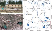
图1
试验区位置示意图"

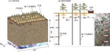
图2
棉花种植方式及传感器、地下水观测孔布置示意图 注:图中单位为cm。"

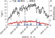
图3
棉花生育期内降水量、日均气温及参考作物蒸散量"

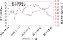
图4
试验区地下水埋深与水质变化"

表1
土壤基本物理特性以及VG参数"
| 深度/m | 土壤物理特性 | VG参数 | |||||||
|---|---|---|---|---|---|---|---|---|---|
| 砂粒/% | 粉粒/% | 黏粒/% | α | n | |||||
| 0~0.35 | 74.65 | 23.63 | 1.72 | 90.62 | 0.029 | 0.398 | 0.047 | 1.549 | |
| 0.35~0.8 | 65.82 | 30.26 | 3.92 | 66.11 | 0.03 | 0.396 | 0.035 | 1.422 | |
| 0.8~1.8 | 88.58 | 10.96 | 0.46 | 304.76 | 0.039 | 0.389 | 0.044 | 2.542 | |
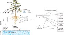
图5
HYDRUS-1D模拟过程示意图"
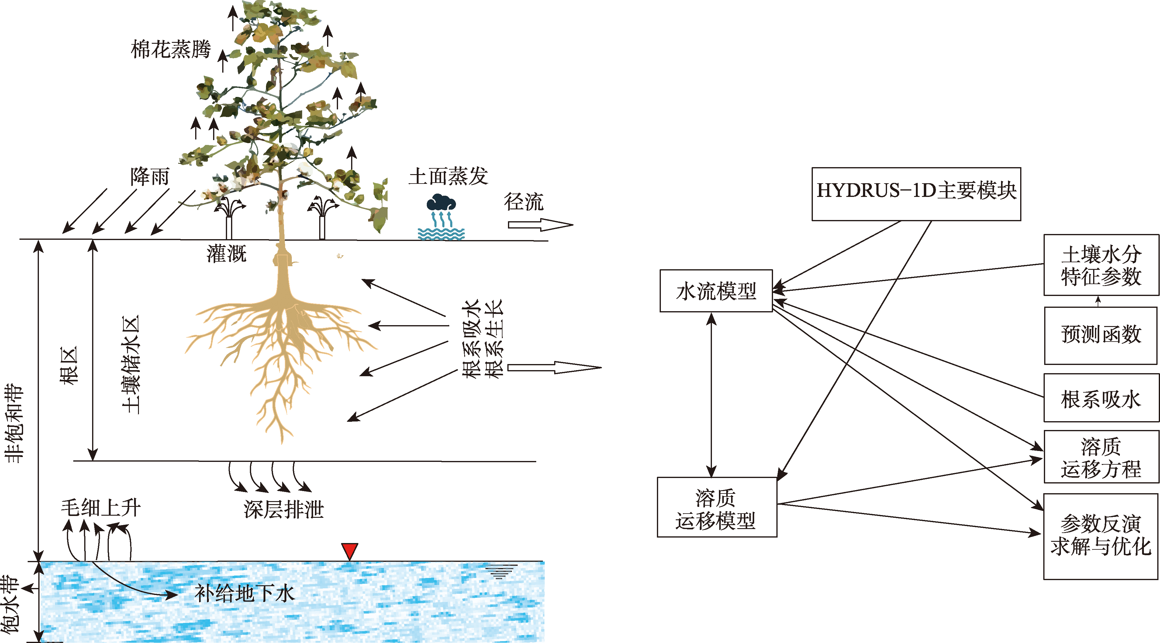
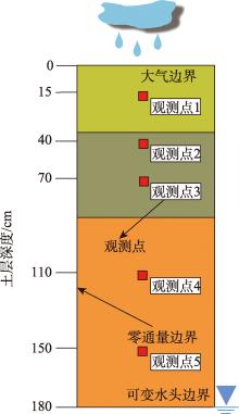
图6
水文地质概念模型"

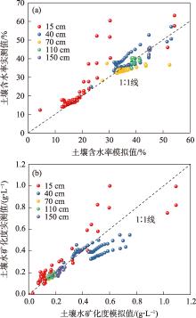
图7
不同土壤深度含水率、TDS的模拟精度比较"

表2
不同土壤深度含水率、TDS的模拟精度检验"
| 拟合参数 | 含水率 | 浓度 | |||
|---|---|---|---|---|---|
| 评价指标 | RMSE | NSE | RMSE | NSE | |
| 15 cm | 0.07 | 0.682 | 0.105 | 0.798 | |
| 30 cm | 0.034 | 0.565 | 0.038 | 0.573 | |
| 70 cm | 0.02 | 0.529 | 0.008 | 0.494 | |
| 110 cm | 0.007 | 0.459 | 0.016 | 0.361 | |
| 150 cm | 0.004 | 0.351 | 0.019 | 0.322 | |
| 总体 | 0.033 | 0.862 | 0.008 | 0.752 | |
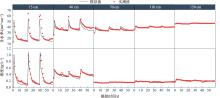
图8
不同深度土壤含水率、浓度的观测值与模拟值拟合结果"

表3
校正后的土壤水力参数与溶质运移参数"
| 深度/m | 土壤类型 | α | n | |||||
|---|---|---|---|---|---|---|---|---|
| 0~0.35 | 粉砂土 | 0.046 | 0.525 | 0.032 | 1.686 | 83.419 | 0.34 | 16.3 |
| 0.35~0.8 | 壤土 | 0.021 | 0.546 | 0.075 | 1.288 | 53.801 | 0.34 | 14.9 |
| 0.8~1.8 | 细砂 | 0.060 | 0.457 | 0.037 | 2.281 | 169.720 | 0.34 | 27.2 |
表4
土壤水分数值模拟均衡"
| 水分 补给项 | 补给水量/mm | 比值/% | 水分 排泄项 | 排泄水 量/mm | 比值/% |
|---|---|---|---|---|---|
| 灌溉水量+降雨量 | 1269.40 | 85.66 | 作物蒸腾 | 333.05 | 24.75 |
| 潜水补给 | 212.42 | 14.34 | 潜水蒸发 | 209.56 | 15.58 |
| 底边界排泄 | 802.94 | 59.67 | |||
| 合计 | 1481.82 | 100 | 合计 | 1345.55 | 100 |
表5
土壤盐分数值模拟均衡"
| 月份 | 进盐量 | 排盐量 | 补给量 | 积盐量 | 总进盐量 | 总排盐量 | 总积盐量 | 脱盐率/% |
|---|---|---|---|---|---|---|---|---|
| /(mg·cm-2) | ||||||||
| 3 | 31.44 | 44.258 | 35.581 | 22.763 | 199.99 | -267.78 | -67.79 | 33.89 |
| 4 | 31.44 | 52.474 | 3.096 | -17.938 | ||||
| 5 | 31.44 | 95.091 | 1.519 | -62.132 | ||||
| 6 | 0 | 21.83 | 0.69 | -21.14 | ||||
| 7 | 32.844 | 52.38 | 8.56 | -10.976 | ||||
| 8 | 0 | 1.75 | 9.34 | 7.59 | ||||
| 9 | 0 | 0 | 14.04 | 14.04 |
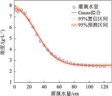
图9
不同灌溉水平下土壤根系层盐分变化"

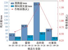
图10
研究区作物生长期间水分蒸散发"

表6
农田棉花灌溉制度优化"
| 棉花生育期 | 灌溉日期/月-日 | 灌溉量/mm |
|---|---|---|
| 春灌 | 03-10—03-25 | 156.85 |
| 苗期 | 04-20—04-30 | 63.35 |
| 蕾期 | 05-25—05-30 | 121.8 |
| 花期 | 06-25—06-30 | 269.5 |
| 吐絮期 | 08-20—08-25 | 88.5 |
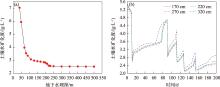
图11
土壤根系层土壤盐分与地下水埋深的关系"

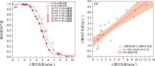
图12
土壤含盐量与棉花产量、土壤水矿化度的相关关系"

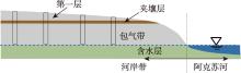
图13
阿克苏河下游河岸带示意图"
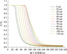
图14
夹壤层位置控制下实际蒸散(Ea)与潜在蒸发量(Ep)在不同地下水位深度下的比值"

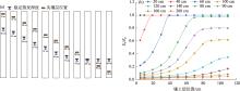
图15
稳定蒸发深度与夹壤层位置的关系(a),不同水位条件下夹壤层位置对实际蒸散(Ea)与潜在蒸发量(Ep)比值的影响(b)"
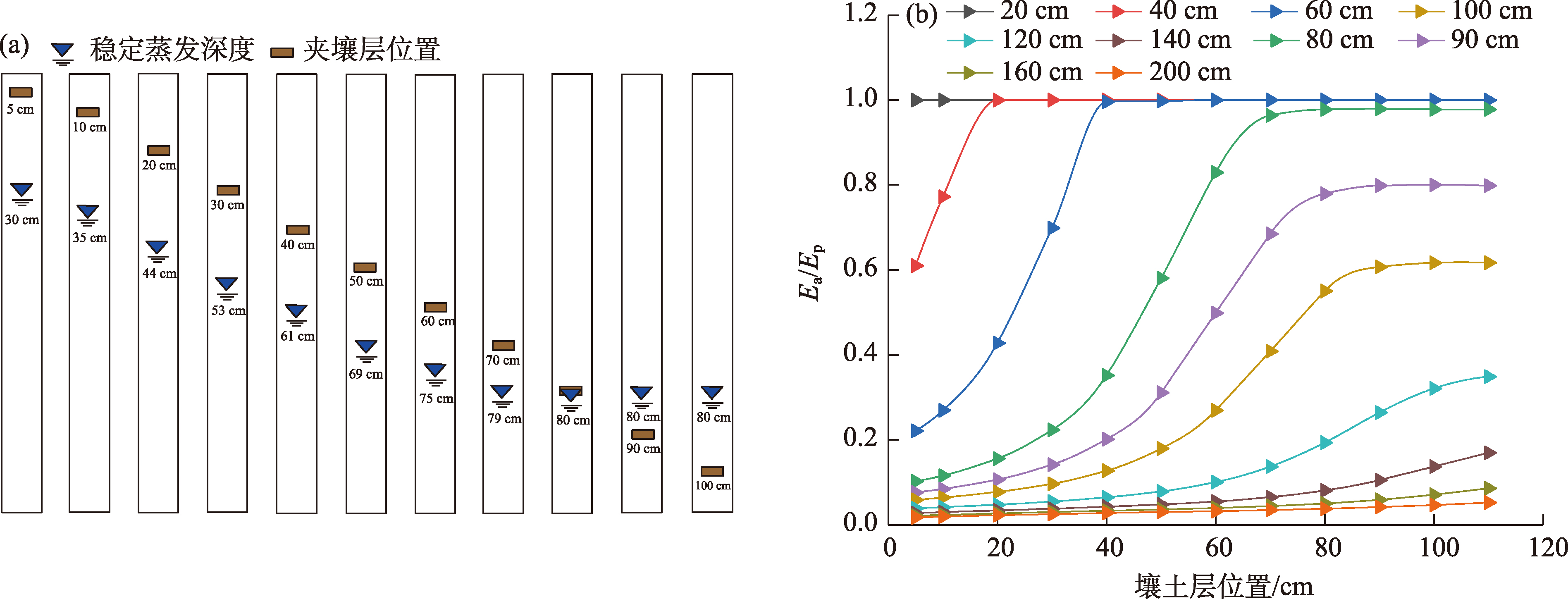
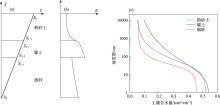
图16
层状土壤稳定蒸发时的吸力S和含水率θ分布示意图"

| [1] |
鲁力, 葛燕燕, 李升, 等. 新疆阿克苏河流域高砷地下水化学特征及富集成因[J]. 干旱区研究, 2025, 42(2): 258-273.
doi: 10.13866/j.azr.2025.02.07 |
| [Lu Li, Ge Yanyan, Li Sheng, et al. Hydrochemical characteristies and enrichment mechanisms of high-arsenicgroundwater in the Aksu River Basin, Xinjiang[J]. Arid Zone Research, 2025, 42(2): 258-273.] | |
| [2] | Lei Y, Liu Y, Sun Z, et al. Influences of paleoclimatic environment and hydrogeochemical evolution on groundwater salinity in an arid inland plain in northwestern China[J]. Applied Geochemistry, 2023, 154: 105688. |
| [3] | Lu L, Li S, Wu R, et al. study on the scale effect of spatial variation in soil salinity based on geostatistics: A case study of yingdaya River Irrigation Area[J]. Land, 2022, 11(10): 1697. |
| [4] | Lu L, Li S, Gao Y, et al. Analysis of the characteristics and cause analysis of soil salt space based on the basin scale[J]. Applied Sciences-Basel, 2022, 12(18): 9022. |
| [5] | 朱会义. 土地利用变化的内在动力——新疆地区农业生产要素产出效率的变动趋势分析[J]. 地理学报, 2013, 68(8): 1029-1037. |
| [Zhu Huiyi. Incentive of land use change: A case study on the variations of agricultural factor productivity in Xinjiang[J]. Acta Geographica Sinica, 2013, 68(8): 1029-1037.] | |
| [6] |
Sheng Y, Tian X, Qiao W, et al. Measuring agricultural total factor productivity in China: Pattern and drivers over the period of 1978-2016[J]. Australian Journal of Agricultural and Resource Economics, 2020, 64(1): 82-103.
doi: 10.1111/1467-8489.12327 |
| [7] | Yan W, Li F, Zhao Y. Determination of irrigation water quantity and its impact on crop yield and groundwater[J]. Agricultural Water Management, 2022, 273: 107900. |
| [8] | Feng G, Zhang Z, Wan C, et al. Effects of saline water irrigation on soil salinity and yield of summer maize (Zea mays L.) in subsurface drainage system[J]. Agricultural Water Management, 2017, 193: 205-213. |
| [9] | Wang W, Chen Y, Wang W, et al. Water quality and interaction between groundwater and surface water impacted by agricultural activities in an oasis-desert region[J]. Journal of Hydrology, 2023, 617: 128937. |
| [10] | Foster S, Pulido-Bbosch A, Vallejos A, et al. Impact of irrigated agriculture on groundwater-recharge salinity: A major sustainability concern in semi-arid regions[J]. Hydrogeology Journal, 2018, 26(8): 2781-2791. |
| [11] | Xie T, Liu X, Sun T. The effects of groundwater table and flood irrigation strategies on soil water and salt dynamics and reed water use in the Yellow River Delta, China[J]. Ecological Modelling, 2011, 222(2): 241-252. |
| [12] | Dou X, Shi H, Li R, et al. Simulation and evaluation of soil water and salt transport under controlled subsurface drainage using HYDRUS-2D model[J]. Agricultural Water Management, 2022, 273: 107899. |
| [13] | Guo S, Li X, Šimůnek J, et al. Experimental and numerical evaluation of soil water and salt dynamics in a corn field with shallow saline groundwater and crop-season drip and autumn post-harvest irrigations[J]. Agricultural Water Management, 2024, 305: 109119. |
| [14] | Che Z, Wang J, Li J. Effects of water quality, irrigation amount and nitrogen applied on soil salinity and cotton production under mulched drip irrigation in arid Northwest China[J]. Agricultural Water Management, 2021, 247: 106738. |
| [15] | Wang H, Feng D, Zhang A, et al. Effects of saline water mulched drip irrigation on cotton yield and soil quality in the North China Plain[J]. Agricultural Water Management, 2022, 262: 107405. |
| [16] | Li W, Wang Z, Zhang J, et al. Soil salinity variations and cotton growth under long-term mulched drip irrigation in saline-alkali land of arid oasis[J]. Irrigation Science, 2022, 40(1): 103-113. |
| [17] | Chen S, Mao X, Shang S. Response and contribution of shallow groundwater to soil water/salt budget and crop growth in layered soils[J]. Agricultural Water Management, 2022, 266: 107574. |
| [18] | Xue J, Huo Z, Wang F, et al. Untangling the effects of shallow groundwater and deficit irrigation on irrigation water productivity in arid region: New conceptual model[J]. Science of the Total Environment, 2018, 619: 1170-1182. |
| [19] | Ma Z, Wang W, Zhang Z, et al. Assessing bare-soil evaporation from different water-table depths using lysimeters and a numerical model in the Ordos Basin, China[J]. Hydrogeology Journal, 2019, 27(7): 2707-2718. |
| [20] | Fahle M, Dietrich O. Estimation of evapotranspiration using diurnal groundwater level fluctuations: Comparison of different approaches with groundwater lysimeter data[J]. Water Resources Research, 2014, 50(1): 273-286. |
| [21] | 中国科学院新疆生物土壤沙漠研究所. 新疆土壤及土地资源研究[M]. 北京: 科学出版社, 1991: 1-37. |
| [Xinjiang Institute of Ecology and Geography, Chinese Academy of Sciences. Research on Xinjiang Soil and Land Resources[M]. Beijing: Science Press, 1991: 1-37.] | |
| [22] | 新疆农业农村厅, 新疆土壤普查办公室. 新疆土壤[M]. 北京: 科学出版社, 1996: 151-521. |
| [Xinjiang Agricultural Department, Xinjiang Soil Survey Office. Xinjiang Soil[M]. Beijing: Science Press, 1996: 151-521.] | |
| [23] | Qi L, Fan J, Shao M, et al. Simulation and verification of soil moisture of root distribution functions for alfalfa[J]. Transactions of the Chinese Society of Agricultural Engineering, 2009, 25(4): 24-29. |
| [24] | Hoffman G, Genuchten M. Soil properties and efficient water use: Water management for salinity control[C]// Taylor H, Jordan W, Sinclair T. Limitations to Efficient Water Use in Crop Production. Madison: American Society of Agronomy, Crop Science Society of America, Soil Science Society of America, 1983: 73-85. |
| [25] | Šimůnek J, Suarez D. Modeling of carbon dioxide transport and production in soil 1. Model development[J]. Water Resources Research, 1993, 29: 487-497. |
| [26] |
张立桢, 曹卫星, 张思平, 等. 棉花根系生长和空间分布特征[J]. 植物生态学报, 2005, 29(2): 266-273.
doi: 10.17521/cjpe.2005.0034 |
|
[Zhang Lizhen, Cao Weixing, Zhang Siping, et al. Characterizing root growth and spatial distribution in cotton[J]. Chinese Journal of Plant Ecology, 2005, 29(2): 266-273.]
doi: 10.17521/cjpe.2005.0034 |
|
| [27] | 胡宏昌, 张治, 田富强, 等. 新疆绿洲棉田盐分及作物生长对灌溉方式的响应[J]. 清华大学学报: 自然科学版, 2016, 56(4): 373-380. |
| [Hu Hongchang, Zhang Zhi, Tian Fuqiang, et al. Response of soil salinity and crop growth toirrigation methods in Xinjiang[J]. Journal of Tsinghua University (Science and Technology), 2016, 56(4): 373-380.] | |
| [28] | Belmans C, Wesseling J, Feddes R. Simulation model of a water balance of a cropped soil[J]. Journal of Hydrology, 1983, 63(3-4): 271-286. |
| [29] | Zhang Y, Zhang F, Fan J, et al. Effects of drip irrigation technical parameters on cotton growth, soil moisture and salinity in Southern Xinjiang[J]. Transactions of the Chinese Society of Agricultural Engineering, 2020, 36(24): 107-117. |
| [30] | Feddes R, Kowalik P, Kolinska-Malinka K, et al. Simulation of field water uptake by plants using a soil water dependent root extraction function[J]. Journal of Hydrology, 1976, 31(1-2): 13-26. |
| [31] | Husan Tumarbay, Wu Z, Su L, et al. Numerical simulation of soil water-salt movement on drip irrigation cotton under film[J]. Soils, 2012, 44(4): 665-670. |
| [32] | 刘洪光, 白振涛, 李开明. 基于HYDRUS-2D模型的膜下滴灌暗管排水棉田土壤盐分变化[J]. 农业工程学报, 2021, 37(2): 130-141. |
| [Liu Hongguang, Bai Zhentao, Li Kaiming. Soil salinity changes in cotton field under mulched drip irrigation with subsurface pipes drainage using HYDRUS-2D model[J]. Transactions of the Chinese Society of Agricultural Engineering, 2021, 37(2): 130-141.] | |
| [33] | Moriasi D, Arnold J, Van L, et al. Model evaluation guidelines for systematic quantification of accuracy in watershed simulations[J]. Transactions of the Asabe, 2007, 50(3): 885-900. |
| [34] | 王璐. 阿克苏河流域盐渍化区包气带水盐运移规律及潜水位动态调控研究[D]. 乌鲁木齐: 新疆大学, 2020. |
| [Wang Lu. Study on the Law of Water and Salt Migration and Dynamic Regulation of Diving Level in the Vadose Zone in the Salinized Area of the Aksu River Basin[D]. Urumqi: Xinjiang University, 2020.] | |
| [35] | DB65/T 4565-2022. 机采棉主要农艺性状指标要求[S]. 乌鲁木齐: 新疆维吾尔自治区市场监督管理局, 2022. |
| [DB65/T 4565-2022. Requirements for Main Agronomic Traits of Machine-Picked Cotton[S]. Urumqi: Xinjiang Uygur Autonomous Region Market Supervision Administration, 2022.] | |
| [36] | 鲁力, 李升, 高远, 等. 渭-库绿洲土壤盐分空间分布及变异特征[J]. 干旱区资源与环境, 2022, 36(3): 136-142. |
| [Lu Li, Li Sheng, Gao Yuan, et al. Spatial distribution and variation characteristics of soil salinity in the oasis of Weigan and Kuga Rivers[J]. Journal of Arid Land Resources and Environment, 2022, 36(3): 136-142.] | |
| [37] | Toonen W H J, Kleinhans M G, Cohen K M. Sedimentary architecture of abandoned channel fills[J]. Earth Surface Processes and Landforms, 2012, 37(4): 459-472. |
| [38] | 李强, 刘天超, 李通, 等. 新疆阿克苏河流域水文地质环境地质调查报告[R]. 乌鲁木齐: 新疆方圆地质矿产勘查院(有限公司), 2019. |
| [Li Qiang, Liu Tianchao, Li Tong, et al. Hydrogeological and Environmental Geological Survey Report of Aksu River Basin in Xinjiang[R]. Urumqi: Xinjiang Fangyuan Geological and Mineral Exploration Institute (Co., Ltd.), 2019.] | |
| [39] | 李艳, 胡顺军, 宋郁东. 渭干河灌区潜水蒸发规律实验分析[J]. 干旱区资源与环境, 2004, 18(3): 92-96. |
| [Li Yan, Hu Shunjun, Song Yudong. Experimental analysis of phreatic evaporation patterns in the Weigan River Irrigation Area[J]. Journal of Arid Land Resources and Environment, 2004, 18(3): 92-96.] | |
| [40] | 来剑斌, 王永平, 蒋庆华, 等. 土壤质地对潜水蒸发的影响[J]. 西北农林科技大学学报(自然科学版), 2003, 31(6): 153-157. |
| [Lai Jianbin, Wang Yongping, Jiang Qinghua, et al. Study on phreatic evaporation under different soil textures[J]. Journal of Northwest A & F University (Natural Science Edition), 2003, 31(6): 153-157.] | |
| [41] | Gong C, Wang W, Zhang Z, et al. Comparison of field methods for estimating evaporation from bare soil using lysimeters in a semi-arid area[J]. Journal of Hydrology, 2020, 590: 125334. |
| [42] | Zhang Z, Wang W, Wang Z, et al. Evaporation from bare ground with different water-table depths based on an in-situ experiment in Ordos Plateau, China[J]. Hydrogeology Journal, 2018, 26(5): 1683-1691. |
| [1] | 王艺璇, 邓晓红, 范慧文青, 韩江哲, 李宗省. 水资源承载力评价耦合模型的研究进展与干旱区应用[J]. 干旱区研究, 2025, 42(6): 1004-1020. |
| [2] | 张秀霞, 韩丽莎, 党星海, 汪孝贤, 林庆润, 邓灵芝, 杨明航, 张喜来. 西北干旱区近30 a植被覆盖的时空变化及其对气候因子的响应[J]. 干旱区研究, 2025, 42(6): 1067-1079. |
| [3] | 王一琪, 买文选, 张文太, 王艳艳, 田长彦. 磷肥滴施条件下土壤温度对棉花生长的影响[J]. 干旱区研究, 2025, 42(6): 1151-1158. |
| [4] | 李琪, 党国锋, 鱼腾飞, 张浪, 陈薇宇. 基于GEE的干旱区县域生态环境质量时空变化及驱动力分析——以阿拉善左旗为例[J]. 干旱区研究, 2025, 42(2): 360-371. |
| [5] | 李双媛, 徐柱, 王玉刚, 孙金金. 干旱区自然资源地表基质细化分类体系构建与调查深度[J]. 干旱区研究, 2025, 42(1): 84-96. |
| [6] | 吕壮壮, 乔庆庆, 董孙艺, 汪冬. 中中新世气候适宜期全球变暖背景下亚洲内陆干旱区古气候演化特征及驱动机制[J]. 干旱区研究, 2024, 41(8): 1309-1322. |
| [7] | 王怡雯, 马瑶瑶, 史培军, 张钢锋. 干旱区光伏电站运营对局地生态环境的影响[J]. 干旱区研究, 2024, 41(8): 1423-1433. |
| [8] | 龙威夷, 施建飞, 李双媛, 孙金金, 王玉刚. 流域绿洲土壤盐分多模型反演效果评估[J]. 干旱区研究, 2024, 41(7): 1120-1130. |
| [9] | 叶虎, 裴浩, 姜艳丰, 那庆, 张立伟. 内蒙古半干旱区气溶胶散射特性及影响因素[J]. 干旱区研究, 2024, 41(5): 730-741. |
| [10] | 雷菲亚, 李小双, 陶冶, 尹本丰, 荣晓莹, 张静, 陆永兴, 郭星, 周晓兵, 张元明. 西北干旱区藓类结皮覆盖下土壤多功能性特征及影响因子[J]. 干旱区研究, 2024, 41(5): 812-820. |
| [11] | 张紫淇, 杨丽莉, 何新林, 李小龙. 滴灌水盐氮调控对棉田水肥盐运移及棉花产量的影响[J]. 干旱区研究, 2024, 41(5): 876-893. |
| [12] | 袁萍, 韩欢, 赵红梅, 李从娟. 裸露与沙埋对极端干旱区凋落物分解和养分释放的影响[J]. 干旱区研究, 2024, 41(2): 293-300. |
| [13] | 赖虹雨, 吕德生, 朱艳, 王振华, 温越, 宋利兵, 齐浩. 生物炭施加对微咸水滴灌棉田土壤水热盐及棉花生长的影响[J]. 干旱区研究, 2024, 41(2): 326-338. |
| [14] | 王若凡, 刘雨欣, 李佩钢, 唐悦, 谢微. 黄河兰州段河岸带沉积物磷的形态分布及释放风险[J]. 干旱区研究, 2024, 41(12): 2035-2044. |
| [15] | 解玉彩, 刘浩, 赵丰年, 张磊, 赵鑫, 师卓, 王兴鹏. 灌溉水矿化度和钠吸附比互作对膜下滴灌棉花生长及产量的影响[J]. 干旱区研究, 2024, 41(12): 2071-2082. |
|
||