干旱区研究 ›› 2024, Vol. 41 ›› Issue (10): 1649-1661.doi: 10.13866/j.azr.2024.10.04 cstr: 32277.14.AZR.20241004
许赟红1( ), 刘琼1, 陈勇航1(), 魏鑫1, 刘鑫1, 张太西2, 邵伟玲2, 杨何群3, 张丞铭1
收稿日期:2024-05-07
修回日期:2024-08-02
出版日期:2024-10-15
发布日期:2024-10-14
通讯作者:
陈勇航. E-mail: yonghangchen@dhu.edu.cn作者简介:许赟红(2000-),女,硕士研究生,主要从事地理遥感研究. E-mail: yunhongxu@mail.dhu.edu.cn
基金资助:
XU Yunhong1(), LIU Qiong1, CHEN Yonghang1(), WEI Xin1, LIU Xin1, ZHANG Taixi2, SHAO Weiling2, YANG Hequn3, ZHANG Chengming1
Received:2024-05-07
Revised:2024-08-02
Published:2024-10-15
Online:2024-10-14
摘要:
基于MODIS MCD12C1土地覆盖和MCD43C3地表反照率数据,分析2002—2021年新疆及周边中亚地区土地覆盖和地表反照率时空分布特征并探讨土地覆盖变化对地表反照率的影响。结果表明:(1) 土地覆盖净变化以裸地和耕地减少、林地和草地增长为主要特征,总变化最大的是草地。塔里木盆地四周裸地转为草地变化明显,中亚中部干旱区草地灌丛化问题严重。(2) 裸地转为草地、草地转为林地分别导致地表反照率减少0.006、增长0.009,草地灌丛化导致地表反照率增长0.012。草地转为裸地对地表反照率的影响最大,变化量为0.015,耕地和草地相互转变对地表反照率的影响最小,变化量<0.001。(3) 2006—2011年地表反照率变化最明显,显著变化量达34.87%。(4)干旱区地表反照率变化显著于其他区域,且林地的地表反照率高于草地和耕地,导致三者间转变的地表反照率变化趋势区别于其他区域。
许赟红, 刘琼, 陈勇航, 魏鑫, 刘鑫, 张太西, 邵伟玲, 杨何群, 张丞铭. 新疆及周边中亚地区土地覆盖变化对地表反照率的影响[J]. 干旱区研究, 2024, 41(10): 1649-1661.
XU Yunhong, LIU Qiong, CHEN Yonghang, WEI Xin, LIU Xin, ZHANG Taixi, SHAO Weiling, YANG Hequn, ZHANG Chengming. Impact of land cover variations on surface albedo in Xinjiang and its surrounding Central Asian region[J]. Arid Zone Research, 2024, 41(10): 1649-1661.
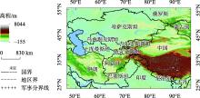
图1
研究区域示意图 注:底图采用自然资源部标准地图制作,审图号为GS(2016)1667号,对底图边界无修改。下同。"

表1
土地覆盖类型"
| 重分类体系 | 原分类体系 | 类型代码 |
|---|---|---|
| 水体 | 水体 | 0 |
| 林地 | 常绿针叶林 | 1 |
| 常绿阔叶林 | 2 | |
| 落叶针叶林 | 3 | |
| 落叶阔叶林 | 4 | |
| 混交林 | 5 | |
| 封闭的灌木丛 | 6 | |
| 开阔的灌木丛 | 7 | |
| 草地 | 稀树草原 | 8 |
| 草原 | 9 | |
| 草地 | 10 | |
| 永久湿地 | 永久湿地 | 11 |
| 耕地 | 耕地 | 12 |
| 耕地或自然植被镶嵌 | 14 | |
| 城市和建筑用地 | 城市和建筑用地 | 13 |
| 永久冰雪 | 永久冰雪 | 15 |
| 裸地 | 裸地 | 16 |
表2
MCD43C3数据集质量标准"
| 代码 | 意义 |
|---|---|
| 0 | 最佳质量,100%完全反演 |
| 1 | 质量好,75%及以上为最佳完全反演和90%及以上为完全反演 |
| 2 | 质量相对较好,75%及以上为完全反演 |
| 3 | 混合,75%及以下的完全反演和25%及以下的填充值 |
| 4 | 50%及以下的填充值 |
| 5 | 50%及以上的填充值 |
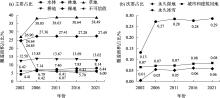
图2
土地覆盖类型面积占比"

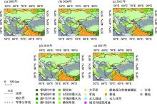
图3
土地覆盖类型空间分布"

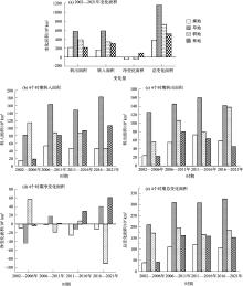
图4
土地覆盖类型变化面积"
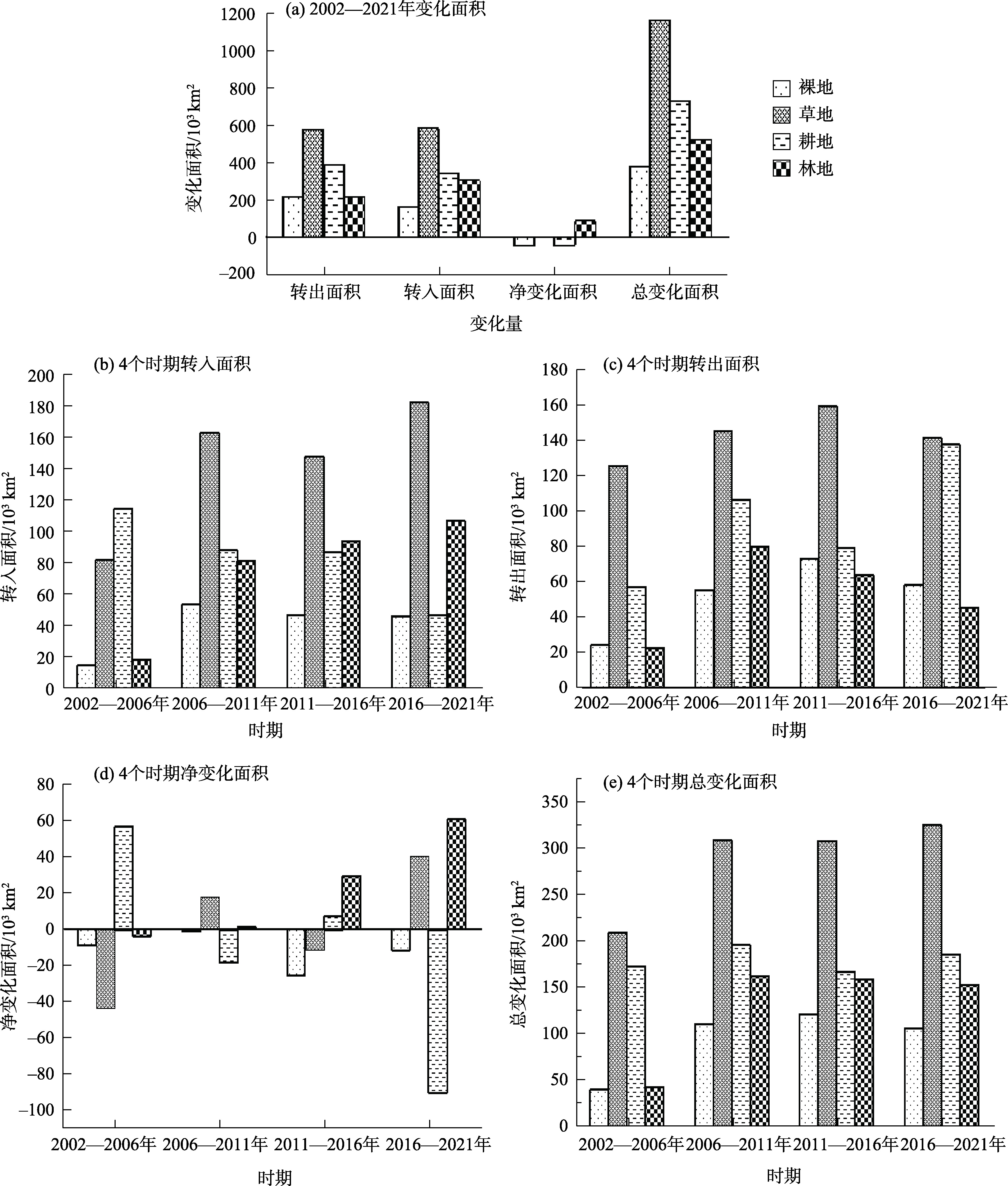
表3
土地覆盖转变情况"
| 转变类型 | 2002—2006年 | 2006—2011年 | 2011—2016年 | 2016—2021年 | 2002—2021年 | |||||
|---|---|---|---|---|---|---|---|---|---|---|
| 面积/km2 | 面积/km2 | 面积/km2 | 面积/km2 | 面积/km2 | 转出比例/% | |||||
| 裸地→草地 | 19409.0 | 33635.8 | 44325.6 | 40441.0 | 137811.3 | 64.77 | ||||
| 裸地→林地 | 3545.9 | 18434.1 | 26602.8 | 15950.4 | 64533.3 | 30.33 | ||||
| 裸地→耕地 | 1684.9 | 3681.7 | 2488.6 | 2578.8 | 10434.0 | 4.90 | ||||
| 草地→耕地 | 105296.7 | 56729.5 | 73393.9 | 38042.5 | 273462.6 | 47.65 | ||||
| 草地→裸地 | 14820.4 | 36934.0 | 28460.0 | 33657.6 | 113872.0 | 19.84 | ||||
| 草地→林地 | 6246.9 | 51907.2 | 58004.1 | 70391.4 | 186549.6 | 32.51 | ||||
| 耕地→草地 | 48400.0 | 95133.0 | 68746.7 | 115062.2 | 327341.8 | 85.41 | ||||
| 耕地→林地 | 9362.2 | 11328.8 | 9592.9 | 21156.7 | 51440.5 | 13.42 | ||||
| 耕地→裸地 | 309.6 | 609.8 | 1585.9 | 1982.2 | 4487.5 | 1.17 | ||||
| 林地→草地 | 14797.8 | 34917.6 | 35339.7 | 27313.3 | 112368.5 | 52.33 | ||||
| 林地→耕地 | 8152.9 | 28641.7 | 11421.1 | 7158.9 | 55374.5 | 25.79 | ||||
| 林地→裸地 | 425.6 | 17062.2 | 17842.2 | 11665.4 | 46995.4 | 21.88 | ||||
图5
土地覆盖变化空间分布"

图6
土地覆盖类型地表反照率均值"
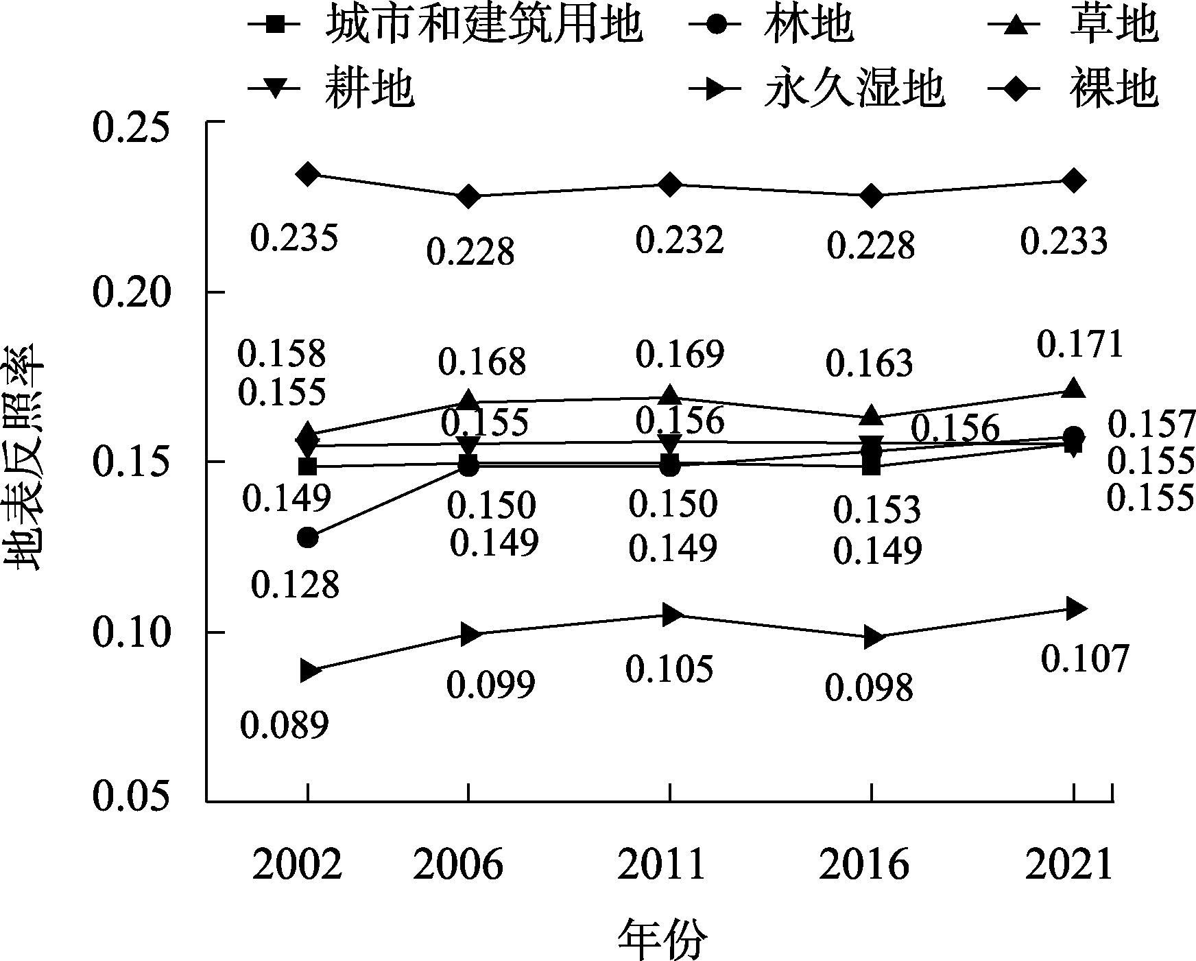
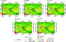
图7
地表反照率空间分布"

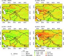
图8
地表反照率变化空间分布"

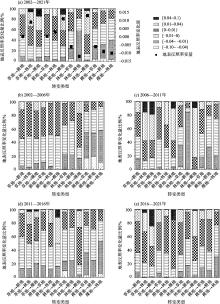
图9
土地覆盖变化导致的地表反照率变化"

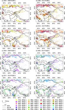
图10
土地覆盖变化导致的地表反照率变化空间分布"

| [1] | Loarie S R, Lobell D B, Asner G P, et al. Direct impacts on local climate of sugar-cane expansion in Brazil[J]. Nature Climate Change, 2011, 1(2): 105-109. |
| [2] |
Sun Y, Zhang X B, Ren G Y, et al. Contribution of urbanization to warming in China[J]. Nature Climate Change, 2016, 6(7): 706-709.
doi: 10.1038/NCLIMATE2956 |
| [3] | 肖登攀, 陶福禄, Moiwo J P. 全球变化下地表反照率研究进展[J]. 地球科学进展, 2011, 26(11): 1217-1224. |
| [Xiao Dengpan, Tao Fulu, Moiwo J P. Research progress on surface albedo under global change[J]. Advances in Earth Science, 2011, 26(11): 1217-1224.] | |
| [4] | Liang S L. Narrowband to broadband conversions of land surface albedo I: Algorithms[J]. Remote Sensing of Environment, 2001, 76(2): 213-238. |
| [5] |
Williamson S N, Barrio I C, Hik D S, et al. Phenology and species determine growing-season albedo increase at the altitudinal limit of shrub growth in the sub-Arctic[J]. Global Change Biology, 2016, 22(11): 3621-3631.
doi: 10.1111/gcb.13297 pmid: 27158930 |
| [6] | 帅艳民, 陈杨杨, 邵聪颖, 等. 东北三省地表覆被变化对太阳辐射吸收的影响[J/OL]. 地球环境学报, 1-22[2024-08-26]. http://kns.cnki.net/kcms/detail/61.1482.X.20230705.1356.002.html. |
| [Shuai Yanmin, Chen Yangyang, Shao Congying, et al. Effect of ground cover changes on solar radiation absorption in three northeastern provinces of China[J/OL]. Journal of Earth Environment, 1-22[2024-08-26]. http://kns.cnki.net/kcms/detail/61.1482.X.20230705.1356.002.html.] | |
| [7] | 石莹, 别强, 苏晓杰, 等. 中国西北地区地表覆被变化对太阳辐射吸收的影响[J/OL]. 自然资源遥感, 1-11[2024-08-26]. http://kns.cnki.net/kcms/detail/10.1759.P.20240125.1638.006.html. |
| [Shi Ying, Bie Qiang, Su Xiaojie, et al. Effects of land cover change on solar radiation absorption in Northwest China[J/OL]. Remote Sensing for Natural Resources, 1-11[2024-08-26]. http://kns.cnki.net/kcms/detail/10.1759.P.20240125.1638.006.html.] | |
| [8] |
孙彦旭, 周自翔, 米朝娟. 基于土地利用覆被变化(LUCC)的人类活动与流域生物多样性灰色关联分析[J]. 干旱区研究, 2021, 38(6): 1782-1792.
doi: 10.13866/j.azr.2021.06.30 |
|
[Sun Yanxu, Zhou Zixiang, Mi Chaojuan. Grey correlation analysis of human activities and watershed biodiversity based on land use and cover change[J]. Arid Zone Research, 2021, 38(6): 1782-1792.]
doi: 10.13866/j.azr.2021.06.30 |
|
| [9] | 陈海山, 张耀存, 张文君, 等. 中国极端天气气候研究——“地球系统与全球变化”重点专项项目简介及最新进展[J]. 大气科学学报, 2024, 47(1): 23-45. |
| [Chen Haishan, Zhang Yaocun, Zhang Wenjun, et al. Research on weather and climate extremes over China: brief introduction and recent progress of the National Key P & D Program of China for Earth System and Global Change[J]. Transactions of Atmospheric Sciences, 2024, 47(1): 23-45.] | |
| [10] |
侯文兵, 李开明, 黄卓. 近20 a河西地区绿洲效应时空变化特征及归因分析[J]. 干旱区研究, 2023, 40(12): 2031-2042.
doi: 10.13866/j.azr.2023.12.15 |
|
[Hou Wenbing, Li Kaiming, Huang Zhuo. Characterization of spatial and temporal changes in the oasis effect and attribution analysis of the Hexi region in the last 20 years[J]. Arid Zone Research, 2023, 40(12): 2031-2042.]
doi: 10.13866/j.azr.2023.12.15 |
|
| [11] |
孙桂丽, 陆海燕, 郑佳翔, 等. 新疆生态脆弱性时空演变及驱动力分析[J]. 干旱区研究, 2022, 39(1): 258-269.
doi: 10.13866/j.azr.2022.01.25 |
|
[Sun Guili, Lu Haiyan, Zheng Jiaxiang, et al. Spatio-temporal variation of ecological vulnerability in Xinjiang and driving force analysis[J]. Arid Zone Research, 2022, 39(1): 258-269.]
doi: 10.13866/j.azr.2022.01.25 |
|
| [12] | 胡汝骥, 姜逢清, 王亚俊, 等. 中亚(五国)干旱生态地理环境特征[J]. 干旱区研究, 2014, 31(1): 1-12. |
| [Hu Ruji, Jiang Fengqing, Wang Yajun, et al. Arid ecological and geographical conditions in five countries of Central Asia[J]. Arid Zone Research, 2014, 31(1): 1-12.] | |
| [13] | 范泽孟, 李赛博. 新亚欧大陆桥经济走廊土地覆被变化及驱动力分析[J]. 生态学报, 2019, 39(14): 5015-5027. |
| [Fan Zemeng, Li Saibo. Change pattern of land cover and its driving force since 2001 in the New Eurasian Continental Bridge Economic Corridor[J]. Acta Ecologica Sinica, 2019, 39(14): 5015-5027.] | |
| [14] | 海凯, 王思远, 涂平, 等. “一带一路”沿线国家1992年—2015年土地覆盖变化的时空格局及其驱动力分析[J]. 遥感学报, 2022, 26(6): 1220-1235. |
| [Hai Kai, Wang Siyuan, Tu Ping, et al. Spatio-temporal patterns and driving forces of recent(1992-2015)land cover change in countries along the Belt and Road Initiative[J]. National Remote Sensing Bulletin, 2022, 26(6): 1220-1235.] | |
| [15] | 姚彤, 张强. 我国北方不同类型下垫面地表反照率特征[J]. 物理学报, 2014, 63(8): 460-468. |
| [Yao Tong, Zhang Qiang. Study on land-surface albedo over different types of underlying surfaces in North China[J]. Acta Physica Sinica, 2014, 63(8): 460-468.] | |
| [16] | 刘亲亲, 崔耀平, 刘素洁, 等. 中国不同土地利用类型分光辐射地表反照率研究[J]. 遥感技术与应用, 2019, 34(1): 46-56. |
| [Liu Qinqin, Cui Yaoping, Liu Sujie, et al. Study on surface albedo of spectral radiation of different land use types in China[J]. Remote Sensing Technology and Application, 2019, 34(1): 46-56.] | |
| [17] | Saher R, Stephen H, Ahmad S. Effect of land use change on summertime surface temperature, albedo, and evapotranspiration in Las Vegas Valley[J]. Urban Climate, 2021, 39: 100966. |
| [18] | 陈杨杨. 典型地表覆被变化对地表反照率的影响[D]. 阜新: 辽宁工程技术大学, 2023. |
| [Chen Yangyang. Effect of Typical Ground Cover Changes on Surface Albedo[D]. Fuxin: Liaoning Technical University, 2023.] | |
| [19] | 何娟. 土地利用变化导致的地表反照率变化及其辐射效应研究[D]. 北京: 中国气象科学研究院, 2020. |
| [He Juan. Changes of Surface Albedo and Its Radiation Effects Caused by Land Use Change[D]. Beijing: Chinese Academy of Meteorological Sciences, 2020.] | |
| [20] | 郑瑜晗, 黄麟, 翟俊, 等. 陆地表层覆盖变化对地表反照率影响的四国对比[J]. 遥感学报, 2020, 24(7): 917-932. |
| [Zheng Yuhan, Huang Lin, Zhai Jun, et al. Impacts of land cover changes on surface albedo in China, the United States, India and Brazil[J]. Journal of Remote Sensing, 2020, 24(7): 917-932.] | |
| [21] |
Zhai J, Liu R G, Liu J Y, et al. Radiative forcing over China due to albedo change caused by land cover change during 1990-2010[J]. Journal of Geographical Sciences, 2014, 24(5): 789-801.
doi: 10.1007/s11442-014-1120-4 |
| [22] | Friedl M A, Sulla-Menashe D, Tan B, et al. MODIS Collection 5 global land cover: Algorithm refinements and characterization of new datasets[J]. Remote Sensing of Environment, 2010, 114(1): 168-182. |
| [23] | Schaaf C B, Gao F, Strahler A H, et al. First operational BRDF, albedo nadir reflectance products from MODIS[J]. Remote Sensing of Environment, 2002, 83(1): 135-148. |
| [24] | Wang Z P, Wu J S, Niu B, et al. Vegetation expansion on the Tibetan Plateau and its relationship with climate change[J]. Remote Sensing, 2020, 12(24): 4150. |
| [25] | Magistrali I C, Delgado R C, dos Santos G L, et al. Performance of CCCma and GFDL climate models using remote sensing and surface data for the state of Rio de Janeiro-Brazil[J]. Remote Sensing Applications Society and Environment, 2021, 21: 100446. |
| [26] | 刘瑞, 朱道林. 基于转移矩阵的土地利用变化信息挖掘方法探讨[J]. 资源科学, 2010, 32(8): 1544-1550. |
| [Liu Rui, Zhu Daolin. Methods for detecting land use changes based on the land use transition matrix[J]. Resource Science, 2010, 32(8): 1544-1550.] | |
| [27] | 任正超, 朱华忠, 柳小妮. 年际尺度上土地覆盖类型时空分异及其对气候和地形的响应[J]. 农业工程学报, 2012, 28(15): 205-214. |
| [Ren Zhengchao, Zhu Huazhong, Liu Xiaoni. Spatio-temporal differentiation of land covers on annual scale and its response to climate and topography in arid and semi-arid region[J]. Transactions of the Chinese Society of Agricultural Engineering, 2012, 28(15): 205-214.] | |
| [28] | 陈爱军, 梁学伟, 卞林根, 等. 青藏高原地区 MODIS 反照率的精度分析[J]. 大气科学学报, 2012, 35(6): 664-672. |
| [Chen Aijun, Liang Xuewei, Bian Lingen, et al. Assessment on the accuracy of MODIS albedos over the Tibetan Plateau[J]. Transactions of Atmospheric Sciences, 2012, 35(6): 664-672.] | |
| [29] | Schaaf C B, Liu J C, Gao F, et al. Aqua and Terra MODIS Albedo and Reflectance Anisotropy Products[M]. New York: Springer: Land Remote Sensing and Global Environmental Change, 2010: 549-561. |
| [30] | 王开存, 刘晶淼, 周秀骥, 等. 利用 MODIS 卫星资料反演中国地区晴空地表短波反照率及其特征分析[J]. 大气科学, 2004, 28(6): 941-949. |
| [Wang Kaicun, Liu Jingmiao, Zhou Xiuji, et al. Retrieval of the surface albedo under clear sky over China and its characteristics analysis by using MODIS satellite date[J]. Chinese Journal of Atmospheric Sciences, 2004, 28(6): 941-949.] | |
| [31] | 陈爱军, 孟文童, 胡慎慎, 等. 青藏高原 MODIS 地表反照率和 GLASS 地表反照率的对比分析[J]. 大气科学学报, 2020, 43(5): 932-942. |
| [Chen Aijun, Meng Wentong, Hu Shenshen, et al. Comparative analysis on land surface albedo from MODIS and GLASS over the Tibetan Plateau[J]. Transactions of Atmospheric Sciences, 2020, 43(5): 932-942.] | |
| [32] | Van Auken O W. Shrub invasions of North American semiarid grasslands[J]. Annual Review of Ecology and Systematics, 2000, 31: 197-215. |
| [33] | 张井勇, 何静, 张丽霞, 等. 面向碳中和的“一带一路”气候变化主要特征与灾害风险研究[J]. 中国科学院院刊, 2023, 38(9): 1371-1386. |
| [Zhang Jingyong, He Jing, Zhang Lixia, et al. Main climate change characteristics and disaster risks oriented towards carbon neutrality over the Belt and Road regions[J]. Bulletin of Chinese Academy of Sciences, 2023, 38(9): 1371-1386.] | |
| [34] | 陈敏鹏, 李玉婷, 代晶晶. 气候变化对“一带一路”主要地区的影响及其适应技术需求[J]. 西北大学学报(自然科学版), 2021, 51(4): 643-654. |
| [Chen Minpeng, Li Yuting, Dai Jingjing. Climate change impacts on major regions along the Belt and Road and technology need for adaptations[J]. Journal of Northwest University(Natural Science Edition), 2021, 51(4): 643-654.] | |
| [35] | 梁萍萍. 喀斯特地区植被变化与地表反照率响应特征研究[D]. 贵阳: 贵州师范大学, 2021. |
| [Liang Pingping. A Study on Response Characteristics of Vegetation Change and Surface Albedo in Karst Area[D]. Guiyang: Guizhou Normal University, 2021.] | |
| [36] | 张亚峰, 王新平, 潘颜霞, 等. 荒漠地区地表反照率与土壤湿度相关性研究[J]. 中国沙漠, 2011, 31(5): 1141-1148. |
| [Zhang Yafeng, Wang Xinping, Pan Yanxia, et al. The dependence of surface albedo on soil moisture in an arid desert area[J]. Journal of Desert Research, 2011, 31(5): 1141-1148.] | |
| [37] |
彭海英, 李小雁, 童绍玉. 干旱半干旱区草原灌丛化研究进展[J]. 草业学报, 2014, 23(2): 313-322.
doi: 10.11686/cyxb20140237 |
| [Peng Haiying, Li Xiaoyan, Tong Shaoyu. Advance in shrub encroachment in arid and semiarid region[J]. Acta Prataculturala Sinica, 2014, 23(2): 313-322.] | |
| [38] | 高琼, 刘婷. 干旱半干旱区草原灌丛化的原因及影响——争议与进展[J]. 干旱区地理, 2015, 38(6): 1202-1212. |
| [Gao Qiong, Liu Ting. Causes and consequences of shrub encroachment in arid and semiarid region: A disputable issue[J]. Arid Land Geography, 2015, 38(6): 1202-1212.] | |
| [39] | Jurena P N, Archer S. Woody plant establishment and spatial heterogeneity in grasslands[J]. Ecology, 2003, 84(4): 907-919. |
| [40] | Shen X J, Liu Y W, Liu B H, et al. Effect of shrub encroachment on land surface temperature in semi-arid areas of temperate regions of the Northern[J]. Agricultural and Forest Meteorology, 2022, 320: 108943. |
| [1] | 孙琳琳, 刘琼, 黄观, 陈勇航, 魏鑫, 郭玉琳, 张太西, 高天一, 许赟红. 新疆和周边“一带一路”地区不同云天条件下地表太阳辐射[J]. 干旱区研究, 2024, 41(9): 1480-1490. |
| [2] | 菅政博, 罗浩, 单娜娜. “双碳”目标下新疆“三生”空间时空演变特征及碳效应[J]. 干旱区研究, 2024, 41(7): 1238-1248. |
| [3] | 柳华清, 王博, 贾妍妍, 解欣然, 张维. 新疆西天山峡谷不同坡位野核桃冻害特征[J]. 干旱区研究, 2024, 41(6): 1079-1088. |
| [4] | 马元植, 覃小林, 凌红波, 闫俊杰, 张广朋. 1991—2020年新疆中小湖泊面积变化时空特征及趋势分析[J]. 干旱区研究, 2024, 41(6): 905-916. |
| [5] | 张皓哲, 薛亚永, 马圆圆, 薛国玄. 新疆绿洲生态系统固碳潜力研究[J]. 干旱区研究, 2024, 41(6): 998-1009. |
| [6] | 白事麟, 吕雅雅, 师小军. 不同生境和基质对经过牛消化道的新疆野苹果种子萌发和幼苗生长的影响[J]. 干旱区研究, 2024, 41(5): 821-829. |
| [7] | 许超杰, 窦燕, 孟琪琳. 基于EMD-GWO-LSTM模型的新疆标准化降水蒸散指数预测方法研究[J]. 干旱区研究, 2024, 41(4): 527-539. |
| [8] | 司琪, 樊浩然, 董文明, 刘新平. 新疆叶尔羌河流域景观生态风险评价及预测[J]. 干旱区研究, 2024, 41(4): 684-696. |
| [9] | 包佳玉, 李祥龙, 胡启文, 李涛. 新疆能源消费碳排放时空特征及能源结构调整路径探讨[J]. 干旱区研究, 2024, 41(3): 490-498. |
| [10] | 姚俊强. 新疆空中水资源和地表水资源变化特征研究[J]. 干旱区研究, 2024, 41(2): 181-190. |
| [11] | 吴明江, 邱娟, 郑凤, 凌孝波, 王新宇, 杨洋, 杨佳鑫, 刘立强. 新疆野果林灌木物种多样性与生态位研究[J]. 干旱区研究, 2024, 41(12): 2094-2109. |
| [12] | 张健, 张宏祥. 新疆野苹果叶绿体基因组特征及其进化历史[J]. 干旱区研究, 2024, 41(12): 2110-2119. |
| [13] | 金晨阳, 杜宏茹. 新疆耕地系统韧性时空变化特征及其分区划定[J]. 干旱区研究, 2024, 41(10): 1778-1788. |
| [14] | 李小锋, 惠婷婷, 李耀明, 毛洁菲, 王光宇, 范连连. 不同放牧管理方式对新疆山地草原植物群落特征的影响[J]. 干旱区研究, 2024, 41(1): 124-134. |
| [15] | 李永广, 苑广辉. 青海湖流域不同下垫面类型对地表温度的生物物理影响[J]. 干旱区研究, 2024, 41(1): 24-35. |
|
||