干旱区研究 ›› 2024, Vol. 41 ›› Issue (4): 684-696.doi: 10.13866/j.azr.2024.04.14
司琪1( ), 樊浩然2, 董文明2, 刘新平1()
收稿日期:2023-08-03
修回日期:2024-01-12
出版日期:2024-04-15
发布日期:2024-04-26
通讯作者:
刘新平. E-mail: 作者简介:司琪(1998-),女,硕士研究生,主要从事土地生态与土地利用研究. E-mail: siqiluckyw@163.com
基金资助:
SI Qi1(), FAN Haoran2, DONG Wenming2, LIU Xinping1()
Received:2023-08-03
Revised:2024-01-12
Online:2024-04-15
Published:2024-04-26
摘要:
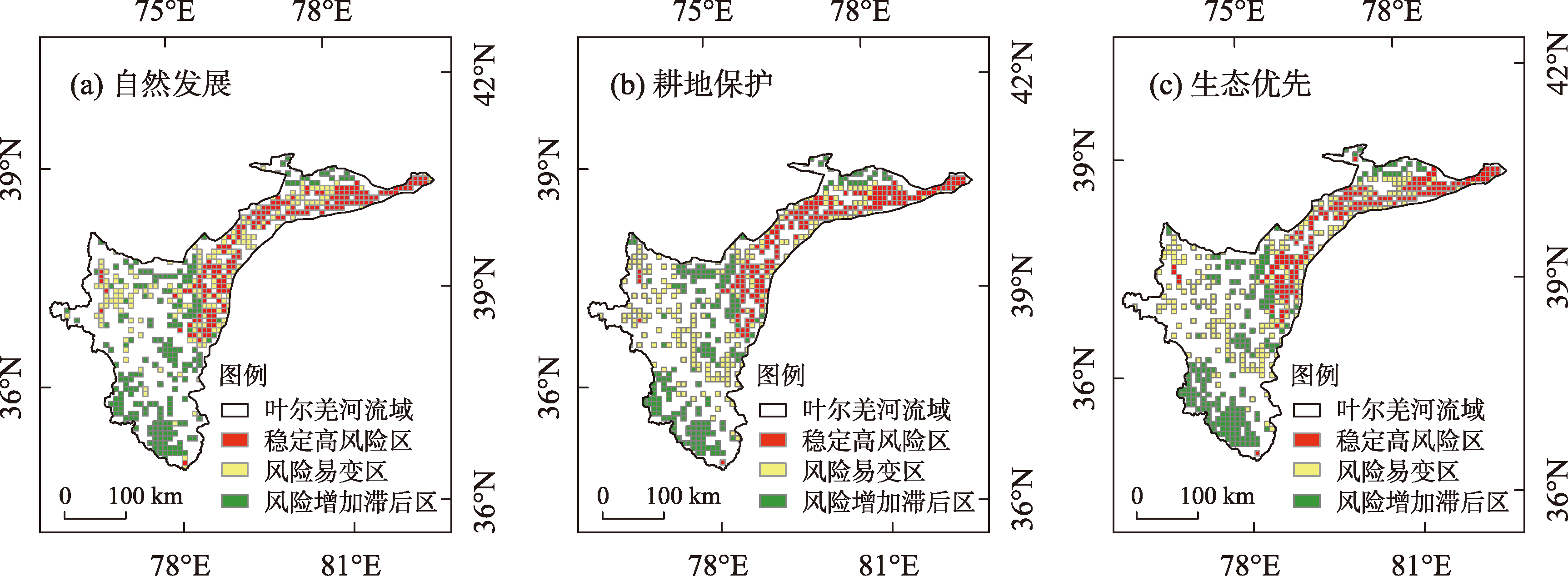
景观生态风险评价是衡量一定范围内生态系统安全的重要手段。以叶尔羌河流域为研究区,综合Markov-PLUS模型与景观生态风险评价指数,分析并预测土地利用与景观生态风险的演变特征及未来多情景下的变化趋势,划分风险重点管理区域。结果表明:(1) 2005—2020年叶尔羌河流域耕地、水体与建设用地增加,林地、草地与未利用地减少。2035年I情景下土地利用遵循历史发展模式变化。相较于I情景,II情景下耕地增加,其他地类减少;III情景下林地、草地与水体增加,耕地、建设用地与未利用地减少。(2) 2005—2035年叶尔羌河流域景观生态风险整体呈上升趋势,空间分布呈“西南部低、东北部高”的特征。风险恶化区主要聚集在海拔较低的冲积平原,风险保持区主要分布在海拔较高的山地与冰川。(3) 较I情景与II情景而言,III情景景观生态风险指数均值较小,是未来流域实现生态保护和经济发展双赢的最优情景。(4) 叶尔羌河流域东北部冲积平原为稳定高风险区,冲积平原边缘与西部山地为风险易变区,南部山地与冰川为风险增加滞后区。研究结果可为当地景观生态安全格局优化与生态风险防范或降低提供参考。
司琪, 樊浩然, 董文明, 刘新平. 新疆叶尔羌河流域景观生态风险评价及预测[J]. 干旱区研究, 2024, 41(4): 684-696.
SI Qi, FAN Haoran, DONG Wenming, LIU Xinping. Landscape ecological risk assessment and prediction for the Yarkant River Basin, Xinjiang, China[J]. Arid Zone Research, 2024, 41(4): 684-696.
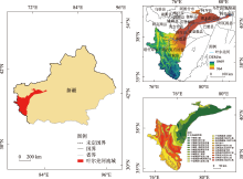
图1
研究区概况 注:底图采用自然资源部标准地图制作,审图号为GS(2022)4312号,对底图边界无修改。下同。"

表1
不同情景参数设定"
| 情景 | 参数设定 |
|---|---|
| 自然发展(I) | 作为一个基准情景,假设各类用地按当前发展规律继续演变,不考虑额外政策干预 |
| 耕地保护(II) | 聚焦于维持和保护耕地,限制耕地向其他地类发生转变,将草地、未利用地向耕地的转移概率提高25%,保持林地、水体和建设用地的转移概率 |
| 生态优先(III) | 强调自然资源和生态系统保护,限制林地、水体向其他地类发生转变,将耕地、草地向建设用地的转移概率减少30%,耕地向林地、草地的转移概率增加15%,未利用地向林地、草地的转移概率增加50% |
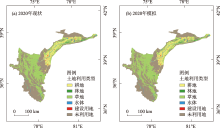
图2
2020年叶尔羌河流域土地利用现状与模拟结果 注:现代冰川归为未利用地。下同。"

表2
景观生态风险评价的景观指数内涵及特点"
| 名称 | 公式、内涵及特点 |
|---|---|
| 景观破碎度 | |
| 景观分离度 | |
| 景观优势度 | |
| 景观干扰度 | |
| 景观脆弱度 | 用于表示景观对外界干扰的敏感度。参考干旱区相关研究[ |
表3
2005—2020年叶尔羌河流域土地利用变化"
| 土地利用类型 | 面积/km2 | 动态度/% | ||||||
|---|---|---|---|---|---|---|---|---|
| 2005年 | 2010年 | 2015年 | 2020年 | 2005—2010年 | 2010—2015年 | 2015—2020年 | ||
| 耕地 | 6601.83 | 7504.97 | 8200.28 | 8215.99 | 2.74 | 1.85 | 0.04 | |
| 林地 | 1714.31 | 1011.08 | 999.63 | 998.59 | -8.20 | -0.23 | -0.02 | |
| 草地 | 31732.06 | 32510.46 | 31910.40 | 31685.92 | 0.49 | -0.37 | -0.14 | |
| 水体 | 927.38 | 1157.84 | 1093.64 | 1129.51 | 4.97 | -1.11 | 0.66 | |
| 建设用地 | 280.38 | 382.11 | 424.01 | 440.06 | 7.26 | 2.19 | 0.76 | |
| 未利用地 | 40631.48 | 39281.19 | 39186.54 | 39162.09 | -0.66 | -0.05 | -0.01 | |
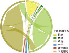
图3
2005—2020年叶尔羌河流域土地利用转移情况"

表4
2035年叶尔羌河流域不同情景下土地利用面积"
| 情景 | 土地利用类型面积/km2 | |||||
|---|---|---|---|---|---|---|
| 耕地 | 林地 | 草地 | 水体 | 建设用地 | 未利用地 | |
| 自然发展(I) | 9565.78 | 925.46 | 31601.80 | 1201.99 | 548.73 | 37967.71 |
| 耕地保护(II) | 10451.83 | 919.68 | 31326.26 | 1153.65 | 501.17 | 37458.78 |
| 生态优先(III) | 8337.43 | 1255.89 | 33189.49 | 1233.38 | 532.29 | 37263.35 |
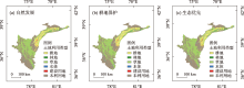
图4
2035年叶尔羌河流域不同情景下土地利用空间分布"
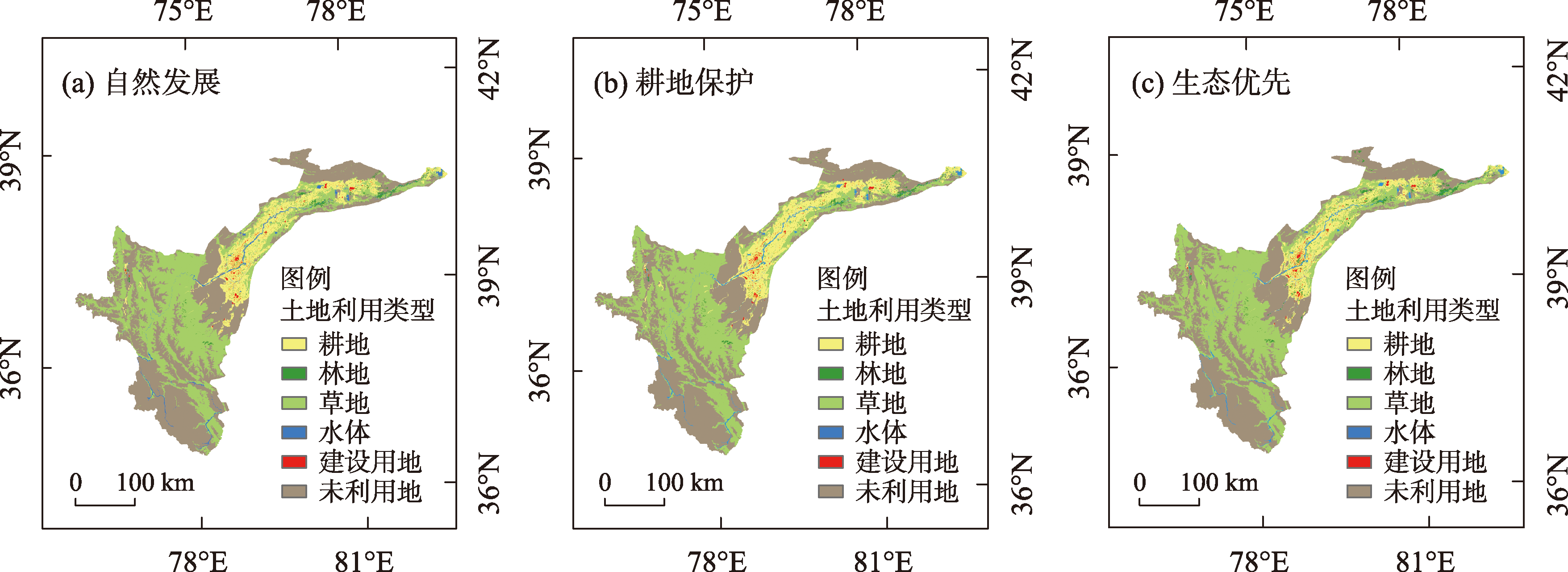

图5
2005—2020年叶尔羌河流域不同等级风险区转移情况"

图6
2005—2020年叶尔羌河流域景观生态风险空间分布"


图7
2035年不同情景下叶尔羌河流域景观生态风险空间分布"


图8
不同情景下叶尔羌河流域风险管理重点区域划分"
| [1] | 马胜. 生态脆弱区不同模型下多尺度景观生态风险评价[D]. 西安: 西北大学, 2019. |
| [Ma Sheng. Multi-scale Landscape Ecological Risk Assessment under Different Models in Ecologically Fragile Regions[D]. Xi’an: Northwest University, 2019.] | |
| [2] |
Bao T T, Wang R F, Song L H, et al. Spatio-temporal multi-scale analysis of landscape ecological risk in Minjiang River Basin based on Adaptive Cycle[J]. Remote Sensing, 2022, 14(21): 5540.
doi: 10.3390/rs14215540 |
| [3] |
彭建, 党威雄, 刘焱序, 等. 景观生态风险评价研究进展与展望[J]. 地理学报, 2015, 70(4): 664-677.
doi: 10.11821/dlxb201504013 |
|
[Peng Jian, Dang Weixiong, Liu Yanxu, et al. Review on landscape ecological risk assessment[J]. Acta Geographica Sinica, 2015, 70(4): 664-677.]
doi: 10.11821/dlxb201504013 |
|
| [4] |
Paukert C P, Pitts K L, Whittier J B, et al. Development and assessment of a landscape-scale ecological threat index for the Lower Colorado River Basin[J]. Ecological Indicators, 2011, 11(2): 304-310.
doi: 10.1016/j.ecolind.2010.05.008 |
| [5] |
Ayre K K, Landis W G. A Bayesian approach to landscape ecological risk assessment applied to the Upper Grande Ronde Watershed, Oregon[J]. Human and Ecological Risk Assessment: An International Journal, 2012, 18(5): 946-970.
doi: 10.1080/10807039.2012.707925 |
| [6] | 刘可暄, 王冬梅, 魏源送, 等. 密云水库流域多尺度景观生态风险时空演变趋势[J]. 生态学报, 2023, 43(1): 105-117. |
| [Liu Kexuan, Wang Dongmei, Wei Yuansong, et al. Spatio-temporal evolution trend of multi-scale landscape ecological risk in Miyun Reservoir watershed[J]. Acta Ecologica Sinica, 2023, 43(1): 105-117.] | |
| [7] |
修炀景, 侯蒙京, 田骄阳, 等. 基于土地利用/覆盖的甘肃省景观生态风险时空变化特征[J]. 草业学报, 2023, 32(1): 1-15.
doi: 10.11686/cyxb2021298 |
|
[Xiu Yangjing, Hou Mengjing, Tian Jiaoyang, et al. Characteristics of temporal and spatial variation in landscape ecological risk in Gansu Province based on land use and cover[J]. Acta Prataculturae Sinica, 2023, 32(1): 1-15.]
doi: 10.11686/cyxb2021298 |
|
| [8] | 蔡葵, 王景, 吴文春, 等. 土地利用驱动下的珠峰自然保护区生态风险研究[J]. 生态科学, 2023, 42(2): 183-192. |
| [Cai Kui, Wang Jing, Wu Wenchun, et al. Qomolangma Nature Reserve ecological risk under land use effect[J]. Ecological Science, 2023, 42(2): 183-192.] | |
| [9] | 王有小, 刘少坤, 林树高, 等. 1995—2018年广西中越边境地区土地利用变化与生态风险研究[J]. 湖南师范大学自然科学学报, 2022, 45(6): 90-98. |
| [Wang Youxiao, Liu Shaokun, Lin Shugao, et al. Study on land use change and ecological risk in Guangxi Areas of Sino-Vietnam border from 1995 to 2018[J]. Journal of Natural Science of Hunan Normal University, 2022, 45(6): 90-98.] | |
| [10] | 丁鸿浩, 贺宏斌, 孙然好. 景观变化的生态风险评价与预测——以河南省洛阳市为例[J]. 地域研究与开发, 2023, 42(1): 167-173. |
| [Ding Honghao, He Hongbin, Sun Ranhao. Dynamic assessment and driving factors of landscape ecological risk based on LUCC: A case study of Luoyang City in Henan Province[J]. Areal Research and Development, 2023, 42(1): 167-173.] | |
| [11] | 王昌博, 李爱农, 张晓荣, 等. 基于遥感和GIS的中巴经济走廊多发展情景生态风险综合评价[J]. 遥感技术与应用, 2021, 36(1): 65-78. |
| [Wang Changbo, Li Ainong, Zhang Xiaorong, et al. Comprehensive assessment of ecological risk in multi-scenarios of China-Pakistan Economic Corridor based on RS and GIS[J]. Remote Sensing Technology and Applications, 2021, 36(1): 65-78.] | |
| [12] | 曾永年, 靳文凭, 王慧敏, 等. 青海高原东部土地利用变化模拟与景观生态风险评价[J]. 农业工程学报, 2014, 30(4): 185-194. |
| [Zeng Yongnian, Jin Wenping, Wang Huimin, et al. Simulation of land-use changes and landscape ecological assessment in eastern part of Qinghai Plateau[J]. Transactions of the Chinese Society of Agricultural Engineering, 2014, 30(4): 185-194.] | |
| [13] | 王佳楠, 张志. 基于Markov-PLUS模型的柴北缘土地利用变化及模拟分析[J]. 西北林学院学报, 2022, 37(3): 139-148, 179. |
| [Wang Jianan, Zhang Zhi. Land use change and simulation analysis in the northern margin of the Qaidam Basin based on Markov-PLUS model[J]. Journal of Northwest Forestry University, 2022, 37(3): 139-148, 179. ] | |
| [14] |
Liang X, Guan Q F, Clarke K C, et al. Understanding the drivers of sustainable land expansion using a patch-generating land use simulation (PLUS) model: A case study in Wuhan, China[J]. Computers, Environment and Urban Systems, 2021, 85: 101569.
doi: 10.1016/j.compenvurbsys.2020.101569 |
| [15] | 张晓东, 赵志鹏, 赵银鑫, 等. 银川市景观生态风险评价与生态安全格局优化构建[J]. 干旱区地理, 2022, 45(5): 1626-1636. |
| [Zhang Xiaodong, Zhao Zhipeng, Zhao Yinxin, et al. Landscape ecological risk assessment and ecological security pattern optimization construction in Yinchuan City[J]. Arid Land Geography, 2022, 45(5): 1626-1636.] | |
| [16] | 李安林, 周艳, 唐丽毅, 等. 怒江州土地利用模拟及生态系统服务价值评估——基于PLUS模型的多情景分析[J]. 中国农业资源与区划, 2023, 44(1): 140-149. |
| [Li Anlin, Zhou Yan, Tang Liyi, et al. Land use simulation and ecosystem services values evaluation in Nujiang Prefecture: A multiple-scenario analysis based on PLUS model[J]. Chinese Journal of Agricultural Resources and Regional Planning, 2023, 44(1): 140-149.] | |
| [17] | 李琛, 高彬嫔, 吴映梅, 等. 基于PLUS模型的山区城镇景观生态风险动态模拟[J]. 浙江农林大学学报, 2022, 39(1): 84-94. |
| [Li Chen, Gao Binpin, Wu Yingmei, et al. Dynamic simulation of landscape ecological risk in mountain towns based on PLUS model[J]. Journal of Zhejiang A & F University, 2022, 39(1): 84-94.] | |
| [18] | 周振宏, 刘东义, 王诗琪, 等. 六安市土地利用动态模拟及景观生态风险评价[J]. 安徽师范大学学报(自然科学版), 2022, 45(5): 443-452. |
| [Zhou Zhenhong, Liu Dongyi, Wang Shiqi, et al. Dynamic simulation of land use and landscape ecological risk assessment in Lu’an City[J]. Journal of Anhui Normal University(Natural Science), 2022, 45(5): 443-452.] | |
| [19] | 孟孟, 张运, 支俊俊, 等. 快速城市化背景下生态系统服务价值时空演变——以南京市为例[J]. 水土保持通报, 2021, 41(3): 296-304. |
| [Meng Meng, Zhang Yun, Zhi Junjun, et al. Spatial-temporal evolution of ecosystem service value under rapid urbanization: A case study of Nanjing City[J]. Bulletin of Soil and Water Conservation, 2021, 41(3): 296-304.] | |
| [20] | 乔斌, 曹晓云, 孙玮婕, 等. 基于生态系统服务价值和景观生态风险的生态分区识别与优化策略——以祁连山国家公园青海片区为例[J]. 生态学报, 2023, 43(3): 986-1004. |
| [Qiao Bin, Cao Xiaoyun, Sun Weijie, et al. Ecological zoning identification and optimization strategies based on ecosystem service value and landscape ecological risk: Taking Qinghai area of QilianM ountain National Park as an example[J]. Acta Ecologica Sinica, 2023, 43(3): 986-1004.] | |
| [21] | 莫贵芬, 冯建中, 王中美, 等. 中亚阿姆河跨境流域景观生态风险时空演变特征分析[J]. 干旱地区农业研究, 2022, 40(1): 123-131. |
| [Mo Guifen, Feng Jianzhong, Wang Zhongmei, et al. Spatial-temporal evolution characteristics of landscape ecological risk in the transboundary basin of Amu Darya River, Central Asia[J]. Agricultural Research in the Arid Areas, 2022, 40(1): 123-131.] | |
| [22] |
Jin X, Jin Y X, Mao X F. Ecological risk assessment of cities on the Tibetan Plateau based on land use/land cover changes-Case study of Delingha City[J]. Ecological Indicators, 2019, 101: 185-191.
doi: 10.1016/j.ecolind.2018.12.050 |
| [23] | 贺洋, 李倞, 徐昉. 先升后降: 2000—2020年博尔塔拉河流域景观生态风险演变[J]. 中国园林, 2022, 38(10): 80-85. |
| [He Yang, Li Jing, Xu Fang. First risen then fallen: Landscape ecological risk evolution in the Bortala River Basin from 2000 to 2020[J]. Chinese Landscape Architecture, 2022, 38(10): 80-85.] | |
| [24] | 沈海岑, 薛联青. 基于土地利用变化的塔里木河下游区近20 a景观生态风险研究[J]. 中国农村水利水电, 2020(11): 77-82. |
| [Shen Haicen, Xue Lianqing. Landscape ecological risk assessment of the lower reaches of Tarim River based on land use change in recent 20 years[J]. China Rural Water and Hydropower, 2020(11): 77-82.] | |
| [25] | 康紫薇, 张正勇, 位宏, 等. 基于土地利用变化的玛纳斯河流域景观生态风险评价[J]. 生态学报, 2020, 40(18): 6472-6485. |
| [Kang Ziwei, Zhang Zhengyong, Wei Hong, et al. Landscape ecological risk assessment in Manas River Basin based on land use change[J]. Acta Ecologica Sinica, 2020, 40(18): 6472-6485.] | |
| [26] |
钟祺康, 王志一, 王娜, 等. 陕北干旱区景观生态风险空间分异特征及驱动因素分析[J]. 测绘通报, 2022(7): 100-106.
doi: 10.13474/j.cnki.11-2246.2022.0211 |
|
[Zhong Qikang, Wang Zhiyi, Wang Na, et al. Spatial differentiation characteristics and driving factors of landscape ecological risk in arid area of northern Shaanxi[J]. Bulletin of Surveying and Mapping, 2022(7): 100-106.]
doi: 10.13474/j.cnki.11-2246.2022.0211 |
|
| [27] | 韩晓佳, 刘小鹏, 王亚娟, 等. 基于景观格局的干旱区绿洲生态风险评价与管理——以青铜峡市为例[J]. 水土保持研究, 2017, 24(5): 285-290. |
| [Han Xiaojia, Liu Xiaopeng, Wang Yajuan, et al. Ecological risk assessment and its management of Oasis in Arid Area based on landscape pattern: A case study in Qingtongxia[J]. Research of Soil and Water Conservation, 2017, 24(5): 285-290.] | |
| [28] | 潘竟虎, 刘晓. 疏勒河流域景观生态风险评价与生态安全格局优化构建[J]. 生态学杂志, 2016, 35(3): 791-799. |
| [Pan Jinghu, Liu Xiao. Landscape ecological risk assessment and landscape security pattern optimization in Shule River Basin[J]. Chinese Journal of Ecology, 2016, 35(3): 791-799.] | |
| [29] |
Ran P, Hu S, Frazier A E, et al. Exploring changes in landscape ecological risk in the Yangtze River Economic Belt from a spatiotemporal perspective[J]. Ecological Indicators, 2022, 137: 108744.
doi: 10.1016/j.ecolind.2022.108744 |
| [30] | 王敏, 胡守庚, 张绪冰, 等. 干旱区绿洲城镇景观生态风险时空变化分析——以张掖绿洲乡镇为例[J]. 生态学报, 2022, 42(14): 5812-5824. |
| [Wang Min, Hu Shougeng, Zhang Xubing, et al. Spatio-temporal evolution of landscape ecological risk in oasis cities and towns of arid areas: A case study of Zhangye Oasis Township[J]. Acta Ecologica Sinica, 2022, 42(14): 5812-5824.] | |
| [31] | 王翠, 李生宇, 雷加强, 等. 叶尔羌河流域气候变化特征及趋势分析[J]. 干旱区资源与环境, 2018, 32(1): 155-160. |
| [Wang Cui, Li Shengyu, Lei Jiaqiang, et al. Regional climate characteristics and its change trend in Yeerqiang river basin[J]. Journal of Arid Land Resources and Environment, 2018, 32(1): 155-160.] | |
| [32] | 任才, 龙爱华, 於嘉闻, 等. 气候与下垫面变化对叶尔羌河源流径流的影响[J]. 干旱区地理, 2021, 44(5): 1373-1383. |
| [Ren Cai, Long Aihua, Yu Jiawen, et al. Effects of climate and underlying surface changes on runoff of Yarkant River Source[J]. Arid Land Geography, 2021, 44(5): 1373-1383.] | |
| [33] | 乌宁巴特, 刘新平, 马相平. 叶尔羌河流域土地生态脆弱性差异评价[J]. 干旱区地理, 2020, 43(3): 849-858. |
| [Wu Ningbart, Liu Xinping, Ma Xiangping. Evaluation on the difference of land ecological vulnerability in the Yarkant River Basin[J]. Arid Land Geography, 2020, 43(3): 849-858.] | |
| [34] | 彭加加, 徐丽萍, 曹翠. 1991—2017年叶尔羌河流域冰川景观格局时空演变[J]. 生态学报, 2022, 42(20): 8265-8275. |
| [Peng Jiajia, Xu Liping, Cao Cui. Spatio-temporal evolution of glacier landscape pattern in the Yarkand River Basin from 1991 to 2017[J]. Acta Ecologica Sinica, 2022, 42(20): 8265-8275.] | |
| [35] | 李华林, 白林燕, 冯建中, 等. 新疆叶尔羌河流域胡杨林时空格局特征[J]. 生态学报, 2019, 39(14): 5080-5094. |
| [Li Hualin, Bai Linyan, Feng Jianzhong, et al. Analysis of spatio-temporal characteristics of Populus euphratica forests in the Yarkand River Basin, Xinjiang[J]. Acta Ecologica Sinica, 2019, 39(14): 5080-5094.] | |
| [36] | 金梦婷, 徐丽萍, 徐权. 基于FLUS-Markov模型的多情景景观生态风险评价与预测——以南疆克州为例[J]. 干旱区研究, 2021, 38(6): 1793-1804. |
| [Jin Mengting, Xu Liping, Xu Quan. FLUS-Markov model-based multiscenario evaluation and prediction of the landscape ecological risk in Kezhou, South Xinjiang[J]. Arid Zone Research, 2021, 38(6): 1793-1804.] | |
| [37] |
Lin X, Wang Z T. Landscape ecological risk assessment and its driving factors of multi-mountainous city[J]. Ecological Indicators, 2023, 146: 109823.
doi: 10.1016/j.ecolind.2022.109823 |
| [38] |
Han N L, Yu M, Jia P H. Multi-scenario landscape ecological risk simulation for sustainable development goals: A case study on the central mountainous area of Hainan Island[J]. International Journal of Environmental Research and Public Health, 2022, 19(7): 4030.
doi: 10.3390/ijerph19074030 |
| [39] | 赵文智, 任珩, 杜军, 等. 河西走廊绿洲生态建设和农业发展的若干思考与建议[J]. 中国科学院院刊, 2023, 38(3): 424-434. |
| [Zhao Wenzhi, Ren Heng, Du Jun, et al. Thoughts and Suggestions on Oasis ecological construction and agricultural development in Hexi Corridor[J]. Bulletin of Chinese Academy of Sciences, 2023, 38(3): 424-434.] | |
| [40] | 郝守宁, 董飞, 刘晓波, 等. 西藏尼洋河流域土地景观格局演变的生态风险分析[J]. 水土保持研究, 2023, 30(2): 378-383, 430. |
| [Hao Shouning, Dong Fei, Liu Xiaobo, et al. Analysis on ecological risk of the evolution of land landscape pattern in the Nyang River Basin[J]. Research of Soil and Water Conservation, 2023, 30(2): 378-383, 430. ] |
| [1] | 许超杰, 窦燕, 孟琪琳. 基于EMD-GWO-LSTM模型的新疆标准化降水蒸散指数预测方法研究[J]. 干旱区研究, 2024, 41(4): 527-539. |
| [2] | 王军, 柴志福, 马浩艳, 赵志锰, 邬佳宾, 付卫平. 基于支持向量机的蓄水工程土地利用分类与动态变化[J]. 干旱区研究, 2024, 41(4): 581-589. |
| [3] | 李文秀, 燕振刚. 基于地理探测器的甘肃农牧交错带土地利用时空演化及其驱动机制[J]. 干旱区研究, 2024, 41(4): 590-602. |
| [4] | 包佳玉, 李祥龙, 胡启文, 李涛. 新疆能源消费碳排放时空特征及能源结构调整路径探讨[J]. 干旱区研究, 2024, 41(3): 490-498. |
| [5] | 李佳珂, 邵战林. 基于PLUS和InVEST模型的乌鲁木齐市碳储量时空演变与预测[J]. 干旱区研究, 2024, 41(3): 499-508. |
| [6] | 姚俊强. 新疆空中水资源和地表水资源变化特征研究[J]. 干旱区研究, 2024, 41(2): 181-190. |
| [7] | 孙玮婕, 乔斌, 于红妍, 赵彤, 陈奇. 基于活力-组织力-恢复力的黑河源区高寒湿地景观生态健康评估[J]. 干旱区研究, 2024, 41(2): 301-313. |
| [8] | 李小锋, 惠婷婷, 李耀明, 毛洁菲, 王光宇, 范连连. 不同放牧管理方式对新疆山地草原植物群落特征的影响[J]. 干旱区研究, 2024, 41(1): 124-134. |
| [9] | 刘一丹, 姚晓军, 李宗省, 胡家瑜. 气候变化和土地利用覆盖变化对河西地区植被净初级生产力的影响[J]. 干旱区研究, 2024, 41(1): 169-180. |
| [10] | 李永广, 苑广辉. 青海湖流域不同下垫面类型对地表温度的生物物理影响[J]. 干旱区研究, 2024, 41(1): 24-35. |
| [11] | 马瑶瑶, 史培军, 徐伟, 张钢锋. 干旱区水电站建设运营生态环境影响遥感监测[J]. 干旱区研究, 2023, 40(9): 1498-1508. |
| [12] | 汪翔, 吕海深, 朱永华, 郭晨煜. 两种河道洪水演进方法在新疆山区的应用比较[J]. 干旱区研究, 2023, 40(8): 1240-1247. |
| [13] | 王超, 马占仓, 潘成南, 吴星月, 宋文丹, 阎平. 新疆苋属新记录植物[J]. 干旱区研究, 2023, 40(8): 1280-1288. |
| [14] | 古丽斯旦·艾尼瓦尔, 吐尔洪·努尔东, 地力胡马尔·阿不都克热木, 买买提明·苏来曼. 新疆薄罗藓科植物新记录[J]. 干旱区研究, 2023, 40(8): 1289-1293. |
| [15] | 李虹, 李忠勤, 陈普晨, 彭加加. 近20 a新疆阿尔泰山积雪时空变化及其影响因素[J]. 干旱区研究, 2023, 40(7): 1040-1051. |
|
||